|
Author
Arrowsmith, John, 1790-1873
Full Title
Madagascar, from original drawings, sketches, diaries & oral information; by J.A. Lloyd Esqre. F.R.S., F.R.G.S. &c. &c. Survr. Genl. of the Maurituus. John Arrowsmith 10 Soho Square, 1850. Lond. Pubd. Feby. 5th. 1850. by John Arrowsmith, 10 Soho Square.
List No
14506.048
Note
Map representing Madagascar. Shows political boundaries, indigenous territory, cities, roads, topography, bodies of water, drainage, coastlines, and islands. Relief shown with hachures. Includes latitudinal and longitudinal lines. With a plan and view of Hova Fort Tamatave. With inset map: Plan of an attack on the defences & town of Tamatave by H.M. Ship Conway, Captn. W. Kelly, in concert with the French Corvettes Berceau & Zelée, Commodore Desfossés & Commander Fierick, June 15th. 1845. Hand-colored engraving. Map is 63 x 49 cm, on double sheet 68 x 56 cm.
Author
Peabody, Elizabeth Palmer
Full Title
Christian Era
List No
15895.000
Author
Mourlhon
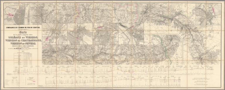
Full Title
(Covers to) Compagnie du chemin de fer du Centre. Carte de la partie comprise entre Orléans et Vierzon. Vierzon et Châteauroux, Vierzon et Nevers
List No
15871.001
Author
Mourlhon
Full Title
Compagnie du chemin de fer du Centre. Carte de la partie comprise entre Orléans et Vierzon. Vierzon et Châteauroux, Vierzon et Nevers
List No
15871.002
Note
Scale of city plans is 1:10,000
Author
Vuillemin, Alexandre
Full Title
France Nouvelle Carte Routiere Donnant les Routes Royales et Departementales avec les distances en Kilometres, Les Chemins de Fer Termines et ceux votes par les Chambres les Canaux et les principales Rivieres navigables, les lignes de Bateaux a vapeur sur l'Ocean . . . 1850
List No
15585.000
Author
Fatout
Full Title
Nouveau Plan Illustre de la ville de Paris avec le systeme complet de ses Fortifications et Forts Detaches . . . 1850
List No
15493.000
Author
Heming, J.L.
Full Title
Plan of Louisville, KY. and the Vicinity.
List No
15164.000
Note
Date estimated.
Author
Wyld, James, 1812-1887
Full Title
(Covers to) New Map Of Central America, Shewing The Different Lines Of Atlantic & Pacific Communication. By James Wyld, Geographer To The Queen & H.R.H. Prince Albert. Charing Cross East, London. 1850. (Copyright). Published by James Wyld ... Jany. 21, 1850. (inset) Isthmus Of Panama. (with 5 profiles).
List No
2737.001
Author
Wyld, James, 1812-1887
Full Title
New Map Of Central America, Shewing The Different Lines Of Atlantic & Pacific Communication. By James Wyld, Geographer To The Queen & H.R.H. Prince Albert. Charing Cross East, London. 1850. (Copyright). Published by James Wyld ... Jany. 21, 1850. (inset) Isthmus Of Panama. (with 5 profiles).
List No
2737.002
Author
Kettner, Vinzenz
Full Title
(Covers to) Karte der Kronländer Görz mit Gradisca und Istrien und der reichsunmittelbaren Stadt Triest mit deren politischen und gerichtlichen Eintheilungen nach den neuesten u. besten Hilfsquelllen verfaßt
List No
10919.001
Author
Kettner, Vinzenz
Full Title
Karte der Kronländer Görz mit Gradisca und Istrien und der reichsunmittelbaren Stadt Triest mit deren politischen und gerichtlichen Eintheilungen nach den neuesten u. besten Hilfsquelllen verfaßt
List No
10919.002
Author
[Willard, Emma, Woodbridge, William C.]
List No
10894.001
Author
[Willard, Emma, Woodbridge, William C.]
Full Title
(Half title page to) Ancient Geography, As Connected with Chronology...
List No
10894.002
Author
[Willard, Emma, Woodbridge, William C.]
Full Title
Prospective Sketch of the Course of Empire...A Plan of Ancient Chronology.
List No
10894.003
Author
[Willard, Emma, Woodbridge, William C.]
Full Title
(Title page to) Ancient Geography, As Connected with Chronology... Accompanied by An Ancient Atlas.
List No
10894.004
Author
[Reynolds, James, Emslie, John]
Full Title
Panoramic plan of the principal rivers and lakes. Drawn & Engraved by John Emslie. London. Published by James Reynolds, 174, Strand. (to accompany) Reynolds introduction to natural philosophy.
List No
13033.034
Note
Hand colored engraved view of the comparative length of the rivers and size of the lakes in the world. Includes list of rivers and lakes beneath the view.
Author
[Reynolds, James, Emslie, John]
Full Title
Mountains. Drawn & Engraved by John Emslie. London. Published by James Reynolds, 174, Strand. (to accompany) Reynolds introduction to natural philosophy.
List No
13033.032
Note
Hand colored engraved view of the comparative heights of mountains and volcanoes from around the world. Includes list of mountains and volcanoes beneath the view.
Author
Engelhardt, Christian Moritz
Full Title
Neue ganz umgearbeitete Panorama-Karte des Monte-Rosa bis zum Matterhorn (Mont-Cervin) ...
List No
10781.000
Author
[Heck, Johann Georg, -1857, Baird, Spencer F.]
Full Title
(Title Page) Iconographic Encyclopaedia of Science, Literature, and Art. Systematically arranged by J.G. Heck. Translated from the German, with additions, and edited by Spencer F. Baird ... in four volumes. Vol. I: Mathematics and Astronomy, Physics and Meteorology, Chemistry, Mineralogy, Geognosy and Geology. New York: 1851. Rudolph Garrigue, Publisher.
List No
12190.002
Author
Heck, Johann Georg, -1857
Full Title
(Title Page) Bilder - Atlas zum Conversations - Lexicon. Ikonographische Encyklopaedie der Wissenschaften und Kuensten. Entworfen und nach den vorzuegsten Quellen bearbeitet von Johann Georg Heck. Erster Abtheilung: Mathemathische und Naturwissenschaften. Mit 141 Tafeln. Leipzig: F.A. Brockhaus. 1849.
List No
12190.031
Author
Heck, Johann Georg, -1857
Full Title
(Diagram) Plate 6. (Celestial Diagrams and Instruments).
List No
12190.039
Author
Heck, Johann Georg, -1857
Full Title
(Diagram) Plate 8. (Seasons, Nebulae, Stars, and Comets).
List No
12190.041
Author
Heck, Johann Georg, -1857
Full Title
Plate 10. (Planet - Moon Relationships).
List No
12190.043
Author
Heck, Johann Georg, -1857
Full Title
Plate 14. (Planet Sizes and Distances).
List No
12190.047
Author
Heck, Johann Georg, -1857
Full Title
(Diagram) Plate 15. (Astronomy: Instruments).
List No
12190.048
Author
Heck, Johann Georg, -1857
Full Title
(Diagram and View) Plate 26. (Clouds, Rainbows, Aurora Borealis).
List No
12190.059
Author
Heck, Johann Georg, -1857
Full Title
(View) Plate 44. (Geology: Landforms).
List No
12190.077
Author
Heck, Johann Georg, -1857
Full Title
Plate 73. (Botany: Plants).
List No
12190.131
Author
Heck, Johann Georg, -1857
Full Title
(View) Plate 80. (Zoology: Animals including Insects.)
List No
12190.138
Author
Heck, Johann Georg, -1857
Full Title
Plate 105b. (Zoology:) Migrations of Fishes and Birds.
List No
12190.164
Author
Heck, Johann Georg, -1857
Full Title
(View) Plate 131. (Anatomy including the Eye.)
List No
12190.190
Author
Heck, Johann Georg, -1857
Full Title
(View) Plate 41. (Roman Fortified Camp; Scipio's Circumvallation of Numantia; Caesar's Seige of Massilia.)
List No
12190.413
Author
Heck, Johann Georg, -1857
Full Title
(View) Plate 48. (Permanent Fortifications.)
List No
12190.420
Author
Heck, Johann Georg, -1857
Full Title
(View) Plate 12. (Decks and Cutaway Lengthwise View of a French Ship of the Line.)
List No
12190.438
Author
Heck, Johann Georg, -1857
Full Title
(View) Plate 32. (Ship Docks, Lighthouses.)
List No
12190.458
Author
Heck, Johann Georg, -1857
Full Title
(View) Plate 18. (Roman Architecture.)
List No
12190.506
Author
Heck, Johann Georg, -1857
Full Title
(View) Plate 36. (Architecture of the Middle Ages.)
List No
12190.524
Author
Heck, Johann Georg, -1857
Full Title
(View) Plate 1. (Indian Gods and Religion.)
List No
12190.550
Author
Heck, Johann Georg, -1857
Full Title
(View) Plate 1. (Construction of Roads; Thames Tunnel.)
List No
12190.612
Author
Heck, Johann Georg, -1857
Full Title
(View) Plate 10. (Construction of Canals and Dams.)
List No
12190.621
Author
Heck, Johann Georg, -1857
Full Title
(View) Plate 19. (Weaving Machines and Tools.)
List No
12190.630
Author
Heck, Johann Georg, -1857
Full Title
(View) Plate 24. (Mining Technology.)
List No
12190.635
Author
Saintin
Full Title
Tableau de la Mythologie presentant la Filiation de tous les Dieux de la Fable. Redigé d'apres les meillieurs mythologues (MM. Noël Champré &c.) et destiné à servir de suite aux Tableaux historiques redigés d'apres le professeur Strass. Nouvelle Edition.
List No
10523.000
Note
Date estimated. A family tree of the Roman gods and their offspring, rooted in the fire and floods of Chaos. Down the sides are 28 vignette portraits of gods, muses and graces. (Altea, 2020)
Author
Vidal, Abbé O.
Full Title
Histoire Détailliée des Révolutions Françaises Depuis 1787 jusqu'a ce Jour.
List No
10524.000
Note
Date estimated. A history of France from the stirrings of revolution in 1787, through the rise and fall of Napoleon, to 1833 and the reign of Louis Philippe. It shows events as a river, with small tributaries and distributaries representing the acquisition or loss of territory. At the top are three battle scenes: the storming of the Tuileries in 1792; the crossing of the Arcole Bridge, 1796; and the storming of the Hôtel de Ville in the July Revolution, 1830. Two columns of portraits of famous figures flank further lists: sieges and battles; principal events; inventions, institutions and monuments; and celebrity deaths.
Author
Hocquart, Édouard
Full Title
Tableau de L'Histoire Sainte, Depuis le Création du Monde jusque'à dispersion des Juifs. Redigé d'après Prideaux, Usserins, John Blair, Lenglet-Dufresnoy., &c.
List No
10525.000
Note
Date estimated. A history of the Holy Land as a river, starting with Adam and Eve, splitting with the sons of Noah and uniting under the Persians and Romans, ending 100AD. An inset map showing the Holy Land divided into the Twelve Tribes. Above the map are written the Twelve Commandments (in French). Down the sides are twenty vignettes of biblical places. Two columns list events and important people. (Altea, 2020)
Author
Hocquart, Édouard
Full Title
Tableau de L'Histoire Romaine depuis les Tems les plus Reculés jusqu'a la Divisin de l'Empire. Redigé d'apès l'Art de vérifier les Dates, les Tables Chronologigues de John Blair, Lenglet-Dufresnoy., &c.
List No
10526.000
Note
Date estimated. A history of Rome depicted as a river, flowing from the black cloud around a volcano, increasing in size as it subsumes other countries into its empire, before splitting up in the fifth century AD. Down the sides are 24 vignettes of the remains of Roman buildings around Europe. Two columns list events and important people, the last entry dated 493. Underneath are the medallion portraits of the emperors from Augustus to Constantine. (Altea, 2020)
Author
Saintin
Full Title
Histoire de la Grèce Depuis les temps les plus reculés jusqua'a sa reduction en province Romaine. Rédigée d'après les meilleures autorités & princip.l d'après le Voyage du Jeune Amacharsis.
List No
10528.000
Note
Date estimated. A history of Classical Greece from 1900 to 82BC, with each state depicted as a river until the fall of Athens meant the whole country become one province of Rome. At the top is a vignette scene of the Spartan army at Thermopylae. Other columns list events, celebrities, and inventions, discoveries and monuments. (Altea, 2020)
Author
Vidal, Abbé O.
Full Title
Tableau de L'Histoire du Bas-Empire, D'apres Le Beau, Gibbon et L'Art de vérifier les Dates.
List No
10532.000
Note
Date estimated. A history of the Roman Empire from 300AD to the fall of Constantinople in 1453, depicted as a river. It splits between the Western and Eastern Empires, and has several small tributaries and distributaries representing the acquisition or loss of territory. The Western Empire ends abruptly with the crowning of Charlemagne; the Eastern Empire flows into the Turkish Empire. Above the chart is an oval view of Constantinople, with crosses on the churches. Down the sides are vignette portraits of figures including Constantine, Belisarius & Mehmet II. (Altea, 2020)
Author
Sun Lithographic Establishment
Full Title
(Covers to) Map of The City Of San Francisco, California. Copied From Originals with Corrections and Additions. 1850. View of San Francisco in 1849. The Large Vessel At The Wharf is The "Apollo Store Ship."
List No
10423.001
Author
Sun Lithographic Establishment
Full Title
Map of The City Of San Francisco, California. Copied From Originals with Corrections and Additions. 1850. View of San Francisco in 1849. The Large Vessel At The Wharf is The "Apollo Store Ship."
List No
10423.002
Note
Gold Rush Historian James Delgado generously shared with us his knowledge of the background of this map: "Moses Yale Beach, the owner/publisher of the New York Sun, purchased Apollo for a speculative voyage to San Francisco in early 1849, and sent it off with a full load pf passengers and cargo, with son Joseph Perkins Beach as the ship’s supercargo, in charge of the business affairs. My book for the Book Club was the edited and annotated journal of the voyage kept by Joseph Perkins Beach. Apollo arrived on September 18, 1849; after the passengers and baggage were offloaded, Joseph, joined by his brother Henry Day Beach, who had come out separately, offered the cargo for sale with Apollo noted as lying off the foot of Sacramento Street. It moved slowly, and the crew deserted, so the Beach brothers decided to run Apollo up onto the mud and turn it into a storeship, as suggested by Moses Beach and also perhaps inspired by Niantic, a July 1849 arrival beached at the foot of Clay (at what is now Clay and Sansome) just as Apollo arrived. The Beach brothers paid $200 to run the ship ashore at the foot of Sacramento on waterlot #171, and there, dismasted, and emptied of ballast, facing west with the stern close to what would become Battery street, Apollo was readied for storeship use. A January 2, 1850 advertisement called for carpenters and wharfing work, and soon the decks were covered by a two-story building that conformed to the shape of the ship. Sixteen days later, they advertised Apollo was ready to “receive goods upon moderate rates of storage.” The Sun Lithographic Establishment, owned by Moses Yale Beach back in New York, published a broadside of the ship advertising it with its “uncommon advantages for storage of all descriptions.” The map just published is clearly another business booster prepared by Papa for his boys (and the family investment). Unfortunately for the Beach’s, the business faltered. Advertisements in the San Francisco Daily Alta California paint a picture of increased desperation, as does private correspondence between the brothers and the folks back in New York. Henry Day beach wrote home in January 1850, noting that “the way I worked and toiled on the Apollo property (I know it has shortened by life 5 years) has effectively cured me of speculation in this country.” The brothers leased the storeship to a firm, Reese & Blakely, in August 1850, but there were dozens of competing storeships. That makes the map all the more interesting, because looking at it, potential investors back east would think there was only one, the centrally located, accessible Apollo. Unless you went, you wouldn’t know of the other ships or of the crowded waterfront that hemmed in Apollo. Hope of recouping the investment vanished when Apollo, along with much of the rest of the city and the waterfront, burned to the ground in the May 4, 1851 fire that devastated the city.
The burned out remains of Apollo were encountered by construction excavation in 1901, 1921 and 1925, and portions of it remain beneath the former Federal Reserve Bank at Sacramento and Battery. Every time I’m in town and walk by, I silently salute Apollo, as well as the buried bones of the storeships Niantic, General Harrison and Thomas Bennett that lie close by. THANK You for finding and presenting this map."
|