|
Author
[Arrowsmith, John, 1790-1873, Light, Wm.]
Full Title
The district of Adelaide, South Australia; as divided into country sections. From the trigonometrical surveys of Colonel Light late Survr. Genl. John Arrowsmith 10 Soho Square. 1839. London, Published Feb. 18th 1840, by John Arrowsmith, 10 Soho Square.
List No
14506.085
Note
Map representing Adelaide, Australia. Shows property boundaries, roads, topography, drainage, and coastlines. Relief shown with hachures. Includes a legend, a compass rose with north oriented toward top of sheet, as well as a bar scale given in miles. Hand-colored engraving. Map is 62 x 51 cm, on double sheet 67 x 56 cm.
Author
Duval, Henri (Henri Louis Nicolas), 1783-1854
Full Title
(Title Page to) Atlas universel des sciences, par Henri Duval, Chevalier de la Légion-d'Honneur; Professeur d'Histoire, de Géographie, de Belles-Lettres, etc., etc. Adopté par le Conseil Royal de l'Instruction Publique pour les Établissements Universitaires, et par let Grand Chancelier pour les Maisons royales d'Éducation de la Légion-d'Honneur. Paris. Terzuolo, Imprimeur-Libraire, Rue Madame, No 30. MDCCCXXXIX.
List No
14254.003
Note
Title page to Atlas universel des sciences. Title translates to: Universal Atlas of Sciences. Includes imprint, as well as an ornamental image of a globe and a volume entitled "Atlas des Sciences".
Author
Duval, Henri (Henri Louis Nicolas), 1783-1854
Full Title
Mappemonde de géographie moderne. Par Henri Duval, Chevalier de la Légion-d'Honneur; Professeur d'Histoire, de Géographie, de Belles-Lettres, etc., etc. Gravé par Laguillermie rue des Noyers No. 56. Delloye, Libraire, Rue des Filles St. Thomas, No 13, Place de la Bourse. Tous les Exemplaires ont le Timbre de l'Auteur. La lettre gravé par Blanchard.
List No
14254.013
Note
Engraved, hand-colored world map as two circular hemispheres: Eastern and Western, showing political boundaries, cities, topography, coastlines, ocean currents and routes of travel. Title translates to: Modern geography world map. Includes latitudinal and longitudinal lines, as well as a legend. Accompanied by descriptive text - surface area, population and political divisions - in circles within margins. Circles are color-coded in association with each continent, such as green for North America and orange for South America. Also features texts describing the oceans and "Climats astronomiques" [= astronomical climates]. Rings around the hemispheres delineate climatic zones, such as "glaciale artique" [= frigid arctic] and "torride" [= torrid]. With addresses in top corners: L'Auteur, Rue des Martyrs, no 23, Chaussée-d'Antin -- Adopté pour les maisons Royles d'Éducation de la Légion-d'Honneur. Map is 34 x 56 cm, on sheet 42 x 61 cm. In second section: Histoire et géographie modernes [= Modern history and geography].
Author
Duval, Henri (Henri Louis Nicolas), 1783-1854
Full Title
Tableau des mythologies anciennes et modernes. Par Henri Duval, Chevalier de la Légion-d'Honneur; Professeur d'Histoire, de Géographie, de Belles-Lettres, etc., etc. Bazouge et Pigoreau Fils, Libraires, Rue des Grands-Augustins, No 21. Person, Libraire, Rue Pavée-S.-André-des-Arcs, No 13. Terzuolo, Libraire, Rue de Vaugirard, No 11. Tous les Exemplaires ont le Timbre de l'Auteur. Imprimerie de Terzuolo, Successeur de M. Plassan, Rue de Vaugirard, No 11.
List No
14254.041
Note
Engraved, black and white view illustrating ancient and modern mythical figures from around the world, together in the clouds. Title translates to: Table of ancient and modern mythologies. Accompanied by descriptive text in tables within margins. With addresses in top corners: L'Auteur, Rue des Martyrs, no 23, Chaussée-d'Antin -- Adopté pour les maisons Royles d'Éducation de la Légion-d'Honneur. View is 17 x 16 cm, on sheet 42 x 61 cm. In second section: Histoire et géographie modernes [= Modern history and geography].
Author
Duval, Henri (Henri Louis Nicolas), 1783-1854
Full Title
Tableau de physique et de météorologie. Par Henri Duval, Chevalier de la Légion-d'Honneur; Professeur d'Histoire, de Géographie, de Belles-Lettres, etc., etc. Delloye, Libraire, Place de la Bourse, No 13. Tous les Exemplaires ont le Timbre de l'Auteur. Imprimerie de Terzuolo, Successeur de M. Plassan, Rue de Vaugirard, No 11.
List No
14254.043
Note
Engraved, hand-colored view illustrating physical and meteorological phenomena, including the science of vision, color and lightning. Title translates to: Physics and meteorology table. Accompanied by descriptive text in tables within margins. With addresses in top corners: L'Auteur, Rue des Martyrs, no 23, Chaussée-d'Antin -- Adopté pour les maisons Royles d'Éducation de la Légion-d'Honneur. View is 18 x 19 cm, on sheet 42 x 61 cm. In third section: Sciences [= Science].
Author
Duval, Henri (Henri Louis Nicolas), 1783-1854
Full Title
Tableau de géologie et des révolutions du globe. Par Henri Duval, Chevalier de la Légion-d'Honneur; Professeur d'Histoire, de Géographie, de Belles-Lettres, etc., etc. Gravé par Laguillermie rue des Noyers No. 56. Delloye, Libraire, Place de la Bourse, No 13. Tous les Exemplaires ont le Timbre de l'Auteur. Imprimerie de Terzuolo, Successeur de M. Plassan, Rue de Vaugirard, No 11.
List No
14254.045
Note
Engraved, hand-colored view illustrating the tallest mountains from around the world, as well as volcanoes. Mountains indexed in association with a table giving peak heights. Title translates to: Table of geology and revolutions of the globe. Accompanied by descriptive text in tables within margins, covering geological phenomena, such as volcanoes, minerals and animal fossils. With addresses in top corners: L'Auteur, Rue des Martyrs, no 23, Chaussée-d'Antin -- Adopté pour les maisons Royles d'Éducation de la Légion-d'Honneur. View is 22 x 23 cm, on sheet 42 x 61 cm. In third section: Sciences [= Science].
Author
Duval, Henri (Henri Louis Nicolas), 1783-1854
Full Title
Tableau d'astronomie et de sphère. Par Henri Duval, Chevalier de la Légion-d'Honneur; Professeur d'Histoire, de Géographie, de Belles-Lettres, etc., etc. Delloye, Libraire, Place de la Bourse, No 13. Tous les Exemplaires ont le Timbre de l'Auteur. Imprimerie de Terzuolo, Successeur de M. Plassan, Rue de Vaugirard, No 11.
List No
14254.046
Note
Engraved, black and white view illustrating astrological phenomena. Title translates to: Astronomy and sphere chart. Accompanied by descriptive text in tables within margins, such as sections on the sun, planets and comets. Figures within illustration numbered in association with text sections. With addresses in top corners: L'Auteur, Rue des Martyrs, no 23, Chaussée-d'Antin -- Adopté pour les maisons Royles d'Éducation de la Légion-d'Honneur. With inset map: [Spherical map of the Eastern Hemisphere]. View is 21 x 33 cm, on sheet 42 x 61 cm. In third section: Sciences [= Science].
Author
Duval, Henri (Henri Louis Nicolas), 1783-1854
Full Title
Ier Tableau d'histoire naturelle : Mammiféres et oiseaux. Par Henri Duval, Chevalier de la Légion-d'Honneur; Professeur d'Histoire, de Géographie, de Belles-Lettres, etc., etc. Gravé par Laguillermie rue des Noyers No. 56. Delloye, Libraire, Place de la Bourse, No 13. Tous les Exemplaires ont le Timbre de l'Auteur. Imprimerie de Terzuolo, Successeur de M. Plassan, Rue Madame, No 30.
List No
14254.047
Note
Engraved, hand-colored view illustrating mammals and birds. Title translates to: First table of natural history : Mammals and birds. Accompanied by descriptive text in tables within margins. Figures within illustration numbered in association with text sections. With addresses in top corners: L'Auteur, Rue des Martyrs, no 23, Chaussée-d'Antin -- Adopté pour les maisons Royles d'Éducation de la Légion-d'Honneur. View is 20 x 28 cm, on sheet 42 x 61 cm. In third section: Sciences [= Science].
Author
Duval, Henri (Henri Louis Nicolas), 1783-1854
Full Title
IIe Tableau d'histoire naturelle : Poissons, reptiles, mollusques, zoophites. Par Henri Duval, Chevalier de la Légion-d'Honneur; Professeur d'Histoire, de Géographie, de Belles-Lettres, etc., etc. Imprimé par Lemarchand. Delloye, Libraire, Place de la Bourse, No 13. Tous les Exemplaires ont le Timbre de l'Auteur. Imprimerie de Terzuolo, Successeur de M. Plassan, Rue de Vaugirard, No 11.
List No
14254.048
Note
Engraved, hand-colored view illustrating mammals and birds. Title translates to: Second table of natural history : Fishes, reptiles, molluscs, zoophites. Accompanied by descriptive text in tables within margins. Figures within illustration numbered in association with text sections. With addresses in top corners: L'Auteur, Rue des Martyrs, no 23, Chaussée-d'Antin -- Adopté pour les maisons Royles d'Éducation de la Légion-d'Honneur. View is 20 x 28 cm, on sheet 42 x 61 cm. In third section: Sciences [= Science].
Author
Duval, Henri (Henri Louis Nicolas), 1783-1854
Full Title
IIIe Tableau d'histoire naturelle : Animaux articulés. Par Henri Duval, Chevalier de la Légion-d'Honneur; Professeur d'Histoire, de Géographie, de Belles-Lettres, etc., etc. Delloye, Libraire, Place de la Bourse, No 13. Tous les Exemplaires ont le Timbre de l'Auteur. Imprimerie de Terzuolo, Successeur de M. Plassan, Rue de Vaugirard, No 11.
List No
14254.049
Note
Engraved, hand-colored view illustrating a variety of vertebrate animals, including crustaceans and insects, such as butterflies. Title translates to: Third table of natural history : Articulated animals. Accompanied by descriptive text in tables within margins. Figures within illustration numbered in association with text sections. With addresses in top corners: L'Auteur, Rue des Martyrs, no 23, Chaussée-d'Antin -- Adopté pour les maisons Royles d'Éducation de la Légion-d'Honneur. View is 19 x 26 cm, on sheet 42 x 61 cm. In third section: Sciences [= Science].
Author
Duval, Henri (Henri Louis Nicolas), 1783-1854
Full Title
IVme Tableau d'histoire naturelle : Botanique. Par Henri Duval, Chevalier de la Légion-d'Honneur; Professeur d'Histoire, de Géographie, de Belles-Lettres, etc., etc. Gravé par Laguillermie rue des Noyers No. 56. Delloye, Libraire, Place de la Bourse, No 13. Tous les Exemplaires ont le Timbre de l'Auteur. Imprimerie de Terzuolo, Successeur de M. Plassan, Rue de Vaugirard, No 11.
List No
14254.050
Note
Engraved, hand-colored view illustrating a variety of plants, including flowers, herbs and fruits. Title translates to: Fourth table of natural history : Botany. Accompanied by descriptive text in tables within margins. Figures within illustration numbered in association with text sections. With addresses in top corners: L'Auteur, Rue des Martyrs, no 23, Chaussée-d'Antin -- Adopté pour les maisons Royles d'Éducation de la Légion-d'Honneur. View is 20 x 25 cm, on sheet 42 x 61 cm. In third section: Sciences [= Science].
Author
Duval, Henri (Henri Louis Nicolas), 1783-1854
Full Title
Tableau de géométrie élémentaire, et d'arpentage. Par Henri Duval, Chevalier de la Légion-d'Honneur; Professeur d'Histoire, de Géographie, de Belles-Lettres, etc., etc. Gravé par Laguillermie rue des Noyers No. 56. Delloye, Libraire, Place de la Bourse, No 13. Tous les Exemplaires ont le Timbre de l'Auteur. Imprimerie de Terzuolo, Successeur de M. Plassan, Rue Madame, No 30.
List No
14254.052
Note
Engraved, hand-colored view illustrating geometry, as applied to surveying, with an inset map as an example. Title translates to: Table of elementary geometry, and surveying. Accompanied by descriptive text in tables within margins. Figures within illustration numbered in association with text sections. With addresses in top corners: L'Auteur, Rue des Martyrs, no 23, Chaussée-d'Antin -- Adopté pour les maisons Royles d'Éducation de la Légion-d'Honneur. With inset map: Plan de Franconville sous Bois (Seine et Oise) [= Map of Franconville sous Bois (Seine and Oise)]. View is 19 x 29 cm, on sheet 42 x 61 cm. In third section: Sciences [= Science].
Author
Duval, Henri (Henri Louis Nicolas), 1783-1854
Full Title
Tableau de dessin linéaire et de perspective. Par Henri Duval, Chevalier de la Légion-d'Honneur; Professeur d'Histoire, de Géographie, de Belles-Lettres, etc., etc. Delloye, Libraire, Place de la Bourse, No 13. Tous les Exemplaires ont le Timbre de l'Auteur. Imprimerie de Terzuolo, Successeur de M. Plassan, Rue Vaugirard, No 11.
List No
14254.053
Note
Engraved, black and white view illustrating line drawing - using geometric shapes as examples - and perspective, as depicted in paintings. Title translates to: Table of linear drawing and perspective. Accompanied by descriptive text in tables within margins. Figures within illustration numbered in association with text sections. With addresses in top corners: L'Auteur, Rue des Martyrs, no 23, Chaussée-d'Antin -- Adopté pour les maisons Royles d'Éducation de la Légion-d'Honneur. View is 18 x 28 cm, on sheet 42 x 61 cm. In third section: Sciences [= Science].
Author
Duval, Henri (Henri Louis Nicolas), 1783-1854
Full Title
Tableau de mécanique. Par Henri Duval, Chevalier de la Légion-d'Honneur; Professeur d'Histoire, de Géographie, de Belles-Lettres, etc., etc. Imprimé par Lemarchand. Delloye, Libraire, Place de la Bourse, No 13. Tous les Exemplaires ont le Timbre de l'Auteur. Imprimerie de Terzuolo, Successeur de M. Plassan, Rue Vaugirard, No 11.
List No
14254.054
Note
Engraved, black and white view illustrating mechanics with a variety of mechanical devices as examples. Title translates to: Table of mechanics. Accompanied by descriptive text in tables within margins. Figures within illustration numbered in association with text sections. With addresses in top corners: L'Auteur, Rue des Martyrs, no 23, Chaussée-d'Antin -- Adopté pour les maisons Royles d'Éducation de la Légion-d'Honneur. View is 14 x 20 cm, on sheet 42 x 61 cm. In third section: Sciences [= Science].
Author
[Fer, Nicolas de, 1646-1720, Bernard, J.F.]
Full Title
L'Europe Suivant les Nouvelles Observations De M.rs De L'Academie Royale Des Siences
List No
15794.000
Author
Brue, Adrien Hubert, 1786-1832
Full Title
Nouvelle Carte du Mexique, Et D'Une Partie Des Provinces Unies De L'Amerique Centrale. Dediee a l'Academie Royale des Sciences de l Institut de France. Par A.H. Brue, Geographe du Roi, Membre de la common. centrale de la societe de Geographie de Paris, membre-honoraire de celle de Londres, &a. Revue et augmentee par Ch. Picquet, Geographe du Roi et du Due d'Orleans, Proprietaire des Cartes et Atlas de Brue, Quai Conti No. 17, pres de l'Institut. Paris, 1839. Publiee en 1834; Revue en 1837, 1839 ... (with 2 inset maps).
List No
5386.001
Note
This is the fourth edition of the 1834 Brue map showing Jedidiah Smith's routes in the west. Although Picquet says this 1839 edition is augmented from the 1834, I can find no changes between the two. Wheat calls the 1834 edition "one of the foundation stones of western mapping history." Jedidiah Smith's geography in the Great Basin and California is shown, based on a letter of Smith describing his journeys published in the Nouvelles Annales de Voyages, Paris 1828 (Wheat). Two insets show the environs of Mexico City and Vera Cruz, and the Yucatan. Texas is still shown as a part of Mexico. Under the title Picquet has added his name as publisher; Picquet acquired all Brue's maps from his widow in 1835. There was a second edition in 1835, and a third in 1837. Wheat does not mention this fourth edition. Map is hand painted in outline color, dissected into 21 sections and mounted on linen. Map folds into loose marbled paper wrappers and then into a marbled paper covered slip case with a red label stamped with "Mexique" in gilt.
Author
W. & A.K. Johnston Limited
Full Title
(Covers to) Edinburgh cabinet atlas.
List No
14296.001
Note
Covers to Edinburgh cabinet atlas by W. & A.K. Johnston Limited, 1839. Bound in black board with brown leather spine and corners. Front cover and spine both have gilded title, as well as ornamentation. With embossed - recessed - decorative pattern.
Author
W. & A.K. Johnston Limited
Full Title
(Title Page to) Dedicated to Her Most Gracious Majesty The Queen. The Edinburgh cabinet atlas comprising maps illustrating the modern geography of every country of the world and the most interesting portions of ancient geography; constructed from the latest & most authentic sources. Edinburgh, W. & A.K. Johnston Engravers & Printers to The Queen. Glasgow Robert Weir; Lumsden & Son: London, Whittaker & Co. Dublin, John Cumming: Paris J.P. Aillaud. 1839.
List No
14296.002
Note
Title page to Edinburgh cabinet atlas by W. & A.K. Johnston Limited, 1839. Includes a dedication to the Queen of England, the imprint and an engraved illustration of a unicorn and lion.
Author
W. & A.K. Johnston Limited
Full Title
(Contents to) Contents. Sketch of the history of geography, and progress of modern discovery. Index to the principal cities, countries, &c. in the world, with tables of longitude and latitude, and reference numbers to each plate.
List No
14296.003
Note
Table of contents to Edinburgh cabinet atlas by W. & A.K. Johnston Limited, 1839. Lists four ancient maps and forty-one modern maps, amounting to a total of forty-five. In addition, lists the Table of the comparative heights of the principal mountains in the world and the Table of the comparative lengths of the principal rivers in the world. Includes an explanatory note beneath the contents listings, beginning: The geography of each country is elucidated by a distinct table of statistics ... With ornamental border. (Page number inferred.)
Author
W. & A.K. Johnston Limited
Full Title
Orbis veteribus notus. Edinburgh W. & A.K. Johnston ; Glasgow; Robert Weir ; Lumsden & Son.
List No
14296.010
Note
Map of the eastern hemisphere, according to ancient geographical knowledge (from a western perspective). Title, in Latin; translates to: [The world known to the ancients]. Shows continental boundaries, cities, routes, topography, deserts, drainage, coastlines and routes of exploration, as well as "Terra incognita, according to Ptolemey". Relief shown pictorially. Includes latitudinal and longitudinal lines, as well as three bar scales and an elaborate compass rose. "Longit ab Ins: Fortun. versus Orientum." Map is 21 x 29 cm, on sheet 27 x 35 cm. Hand-colored engraving. In first section of atlas, Ancient maps.
Author
W. & A.K. Johnston Limited
Full Title
Western Hemisphere. Edinburgh; W. & A.K. Johnston ; Glasgow; Robert Weir ; Lumsden & Son.
List No
14296.014
Note
Circular map of the Western Hemisphere. Shows political boundaries, cities, routes, topography, drainage, coastlines and islands. Relief shown pictorially. Includes latitudinal and longitudinal lines. Map is 22 x 21 cm, on sheet 35 x 27 cm. Hand-colored engraving. In second section of atlas, Modern maps.
Author
W. & A.K. Johnston Limited
Full Title
Eastern Hemisphere. Edinburgh; W. & A.K. Johnston ; Glasgow; Robert Weir ; Lumsden & Son.
List No
14296.015
Note
Circular map of the Eastern Hemisphere. Shows political boundaries, cities, routes, topography, deserts, drainage, coastlines and islands. Relief shown pictorially. Includes latitudinal and longitudinal lines. Map is 22 x 21 cm, on sheet 35 x 27 cm. Hand-colored engraving. In second section of atlas, Modern maps.
Author
W. & A.K. Johnston Limited
Full Title
The world on Mercator's projection. Edinburgh W. & A.K. Johnston ; Glasgow Robert Weir ; Lumsden & Son.
List No
14296.016
Note
Map of the world. Shows political boundaries, cities, routes, topography, deserts, drainage, coastlines and islands. Relief shown pictorially. Includes latitudinal and longitudinal lines. "Long. East from Greenwich." Map is 29 x 43 cm, on sheet 35 x 54 cm. Hand-colored engraving on double plate. In second section of atlas, Modern maps.
Author
W. & A.K. Johnston Limited
Full Title
Europe. Edinburgh; W. & A.K. Johnston ; Glasgow; Robert Weir ; Lumsden & Son.
List No
14296.017
Note
Map of Europe and vicinity. Shows political boundaries, cities, routes, topography, drainage, coastlines and islands. Relief shown pictorially. Includes latitudinal and longitudinal lines, as well as a bar scale. With a statistical table featuring surface area, population, revenue and debt. Map is 21 x 29 cm, on sheet 27 x 35 cm. Hand-colored engraving. In second section of atlas, Modern maps.
Author
W. & A.K. Johnston Limited
Full Title
Asia. Edinburgh; W. & A.K. Johnston ; Glasgow; Robert Weir ; Lumsden & Son.
List No
14296.036
Note
Map of Asia and vicinity. Shows political boundaries, cities, routes, topography, drainage, coastlines and islands. Relief shown pictorially. Includes latitudinal and longitudinal lines, as well as a bar scale. "Longitude East from Greenwich." With a statistical table featuring surface area and population. Map is 30 x 23 cm, on sheet 35 x 27 cm. Hand-colored engraving. In second section of atlas, Modern maps.
Author
W. & A.K. Johnston Limited
Full Title
East India Islands and Australia. Edinburgh; W. & A.K. Johnston ; Glasgow; Robert Weir ; Lumsden & Son.
List No
14296.042
Note
Map of the East Indies and Australia. Shows political boundaries, cities, topography, drainage, coastlines and islands. Relief shown with hachures. Includes latitudinal and longitudinal lines, as well as a bar scale. "Longitude East from Greenwich." With a statistical table featuring surface area, population, capital city and religion. Map is 23 x 29 cm, on sheet 27 x 35 cm. Hand-colored engraving. In second section of atlas, Modern maps.
Author
W. & A.K. Johnston Limited
Full Title
New South Wales. Edinburgh; W. & A.K. Johnston ; Glasgow; Robert Weir ; Lumsden & Son.
List No
14296.043
Note
Map of New South Wales (Australia) and vicinity. Shows political boundaries, cities, routes, topography, drainage, coastlines and islands. Relief shown with hachures. Includes latitudinal and longitudinal lines, as well as a bar scale. "Long. East from Greenwich." With a statistical table featuring surface area and population - settlers and convicts - as well as imports and exports, including the importation of British convicts. Map is 29 x 21 cm, on sheet 35 x 27 cm. Hand-colored engraving. In second section of atlas, Modern maps.
Author
W. & A.K. Johnston Limited
Full Title
Africa. Edinburgh: W. & A.K. Johnston ; Glasgow: Robert Weir ; Lumsden & Son.
List No
14296.045
Note
Map of Africa and vicinity. Shows political boundaries, cities, routes, topography, deserts, drainage, coastlines and islands. Relief shown pictorially. Includes latitudinal and longitudinal lines, as well as a bar scale. "Long. W. from Greenwich." With a statistical table featuring surface area, population and religion. Map is 29 x 21 cm, on sheet 35 x 27 cm. Hand-colored engraving. In second section of atlas, Modern maps.
Author
W. & A.K. Johnston Limited
Full Title
America. Edinburgh; W. & A.K. Johnston ; Glasgow; Robert Weir ; Lumsden & Son.
List No
14296.048
Note
Map of the Americas and vicinity, including the Arctic Ocean. Shows political boundaries, cities, routes, topography, drainage, coastlines and islands. Relief shown pictorially. Includes latitudinal and longitudinal lines, as well as a bar scale. "Long. West from Greenwich." With a statistical table featuring surface area, population and a historical note. Map is 29 x 21 cm, on sheet 35 x 27 cm. Hand-colored engraving. In second section of atlas, Modern maps.
Author
W. & A.K. Johnston Limited
Full Title
North America. Edinburgh; W. & A.K. Johnston ; Glasgow; Robert Weir ; Lumsden & Son.
List No
14296.049
Note
Map of North America and vicinity, including the Arctic Ocean. Shows political boundaries, cities, routes, topography, drainage, coastlines and islands. Relief shown pictorially. Includes latitudinal and longitudinal lines, as well as a bar scale. "Long. W. from Greenwich." With a statistical table featuring surface area and population. Map is 21 x 29 cm, on sheet 27 x 35 cm. Hand-colored engraving. In second section of atlas, Modern maps.
Author
W. & A.K. Johnston Limited
Full Title
United States. Edinburgh; W. & A.K. Johnston ; Glasgow; Robert Weir ; Lumsden & Son.
List No
14296.050
Note
Map of the eastern United States and vicinity, including the West Indies. Shows political boundaries, cities, routes, topography, prairies, drainage, coastlines and islands. Relief shown pictorially. Includes latitudinal and longitudinal lines, as well as a bar scale. "Longitude West from Greenwich." With a statistical table featuring surface area, population, capital city, revenue, debt, military resources and religion. Map is 22 x 29 cm, on sheet 27 x 35 cm. Hand-colored engraving. In second section of atlas, Modern maps.
Author
W. & A.K. Johnston Limited
Full Title
Polar regions shewing the recent discoveries. Edinburgh; W. & A.K. Johnston ; Glasgow; Robert Weir ; Lumsden & Son.
List No
14296.054
Note
Map of the Arctic Regions, including the Arctic Ocean. Shows political boundaries, cities, topography, drainage, coastlines and islands, as well as routes of exploration, with names of explorers and dates of voyages, such as "Capt. Parry going out 1821 ... returning 1822. Relief shown pictorially. Includes latitudinal and longitudinal lines. "Long. West from Greenwich." Map is 29 x 43 cm, on sheet 35 x 54 cm. Hand-colored engraving on double plate. In second section of atlas, Modern maps.
Author
W. & A.K. Johnston Limited
Full Title
Table of the comparative heights of the principal mountains in the world. Edinburgh; W. & A.K. Johnston ; Glasgow; Robert Weir ; Lumsden & Son.
List No
14296.055
Note
Chart of mountain heights around the world. Shows elevations of peaks - in thousands of feet - from tallest to shortest. Peaks indexed with letters; explanatory table at upper right, providing the name of each mountain and its location (according to country), and height in feet. Includes volcanoes, which are indicated by puffs of smoke. Descriptive note, beginning: The region of perpetual snow begins under the equator at 15,747 feet above the level of the sea ... With two inset charts: Passes of the Alps, above the level of the sea -- Altitude of towns, above the level of the sea. Chart is 21 x 29 cm, on sheet 27 x 35 cm. Black and white engraving. Unnumbered plate. In second section of atlas, Modern maps.
Author
W. & A.K. Johnston Limited
Full Title
Table of the comparative lengths of the principal rivers in the world. Edinburgh; W. & A.K. Johnston ; Glasgow; Robert Weir ; Lumsden & Son.
List No
14296.056
Note
Chart of river lengths around the world. Shows lengths of rivers - in thousands of miles - from longest to shortest. River representations indexed with letters; explanatory table at lower left, providing the name of each river, its mouth and course, such as - for the Amazon River - the Atlantic Ocean and South America, respectively, as well as its length in miles. Chart is 21 x 29 cm, on sheet 27 x 35 cm. Black and white engraving. Unnumbered plate. In second section of atlas, Modern maps.
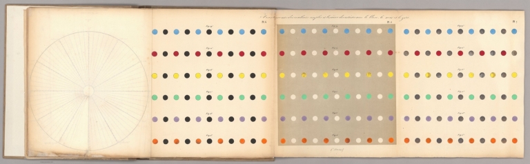
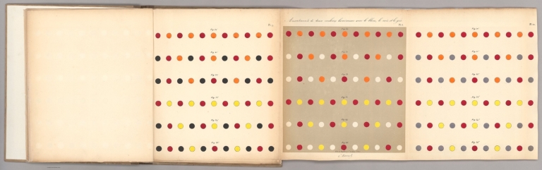
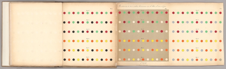
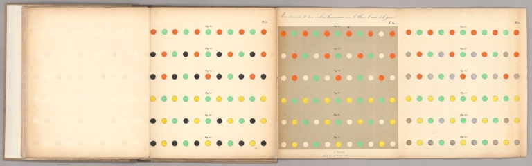
Author
CHEVREUL, MICHEL-EUGÈNE
Full Title
(Covers to) De la loi du contraste simultané des couleurs, et de l’Assortiment des objets colorés.
List No
15463.001
Author
CHEVREUL, MICHEL-EUGÈNE
Full Title
(Title page to) De la loi du contraste simultané des couleurs, et de l’Assortiment des objets colorés.
List No
15463.002
Author
CHEVREUL, MICHEL-EUGÈNE
Full Title
(Text page to) De la loi du contraste simultané des couleurs, et de l’Assortiment des objets colorés.
List No
15463.003
Author
CHEVREUL, MICHEL-EUGÈNE
Full Title
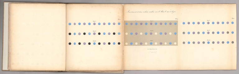
Plate 1. De la loi du contraste simultané des couleurs, et de l’Assortiment des objets colorés.
List No
15463.004
Author
CHEVREUL, MICHEL-EUGÈNE
Full Title
Plate 2. De la loi du contraste simultané des couleurs, et de l’Assortiment des objets colorés.
List No
15463.005
Author
CHEVREUL, MICHEL-EUGÈNE
Full Title
Plate 3. De la loi du contraste simultané des couleurs, et de l’Assortiment des objets colorés.
List No
15463.006
Author
CHEVREUL, MICHEL-EUGÈNE
Full Title
Plate 4. De la loi du contraste simultané des couleurs, et de l’Assortiment des objets colorés.
List No
15463.007
Author
CHEVREUL, MICHEL-EUGÈNE
Full Title
Plate 4. De la loi du contraste simultané des couleurs, et de l’Assortiment des objets colorés.
List No
15463.008
Author
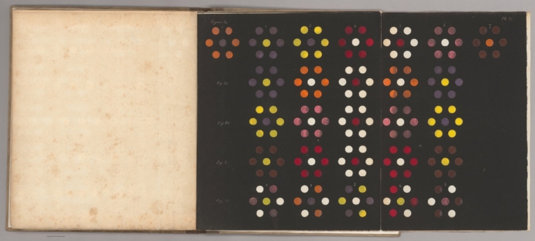
CHEVREUL, MICHEL-EUGÈNE
Full Title
Plates 5, 6, 7. De la loi du contraste simultané des couleurs, et de l’Assortiment des objets colorés.
List No
15463.009
Author
CHEVREUL, MICHEL-EUGÈNE
Full Title
Plates 8, 9, 10. De la loi du contraste simultané des couleurs, et de l’Assortiment des objets colorés.
List No
15463.010
Author
CHEVREUL, MICHEL-EUGÈNE
Full Title
Plates 11, 12, 13. De la loi du contraste simultané des couleurs, et de l’Assortiment des objets colorés.
List No
15463.011
Author
CHEVREUL, MICHEL-EUGÈNE
Full Title
Plates 14, 15, 16. De la loi du contraste simultané des couleurs, et de l’Assortiment des objets colorés.
List No
15463.012
Author
CHEVREUL, MICHEL-EUGÈNE
Full Title
Plates 17, 18, 19. De la loi du contraste simultané des couleurs, et de l’Assortiment des objets colorés.
List No
15463.013
Author
CHEVREUL, MICHEL-EUGÈNE
Full Title
Plates 20, 21, 22. De la loi du contraste simultané des couleurs, et de l’Assortiment des objets colorés.
List No
15463.014
Author
CHEVREUL, MICHEL-EUGÈNE
Full Title
Plates 23, 24, 25. De la loi du contraste simultané des couleurs, et de l’Assortiment des objets colorés.
List No
15463.015
Author
CHEVREUL, MICHEL-EUGÈNE
Full Title
Plates 26, 27, 28. De la loi du contraste simultané des couleurs, et de l’Assortiment des objets colorés.
List No
15463.016
Author
CHEVREUL, MICHEL-EUGÈNE
Full Title
Plates 29, 30, 31. De la loi du contraste simultané des couleurs, et de l’Assortiment des objets colorés.
List No
15463.017
Author
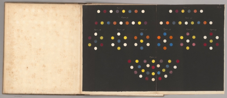
CHEVREUL, MICHEL-EUGÈNE
Full Title
Plate 34. De la loi du contraste simultané des couleurs, et de l’Assortiment des objets colorés.
List No
15463.029
Author
CHEVREUL, MICHEL-EUGÈNE
Full Title
Plate 35. De la loi du contraste simultané des couleurs, et de l’Assortiment des objets colorés.
List No
15463.030
Author
CHEVREUL, MICHEL-EUGÈNE
Full Title
Plate 36. De la loi du contraste simultané des couleurs, et de l’Assortiment des objets colorés.
List No
15463.031
Author
CHEVREUL, MICHEL-EUGÈNE
Full Title
Plate 37. De la loi du contraste simultané des couleurs, et de l’Assortiment des objets colorés.
List No
15463.032
Author
CHEVREUL, MICHEL-EUGÈNE
Full Title
Plate 38. De la loi du contraste simultané des couleurs, et de l’Assortiment des objets colorés.
List No
15463.033
Author
CHEVREUL, MICHEL-EUGÈNE
Full Title
Plate 39. De la loi du contraste simultané des couleurs, et de l’Assortiment des objets colorés.
List No
15463.034
Author
[Visconti, Sigismond, Dufour, Auguste-Henri (1798-1865)]
Full Title
Orbite de la Revolution annuelle de la Terre autour du Soleil (No. 2)
List No
15413.002
Author
[Visconti, Sigismond, Dufour, Auguste-Henri (1798-1865)]
Full Title
Planisphere (No.3)
List No
15413.003
Author
[Visconti, Sigismond, Dufour, Auguste-Henri (1798-1865)]
Full Title
Phases de la Lune (No. 4)
List No
15413.004
Author
[Visconti, Sigismond, Dufour, Auguste-Henri (1798-1865)]
Full Title
Eclipses de Soleil et de Lune (No. 5)
List No
15413.005
Author
[Visconti, Sigismond, Dufour, Auguste-Henri (1798-1865)]
Full Title
Le Flux et le Reflux (No. 6)
List No
15413.006
Author
[Visconti, Sigismond, Dufour, Auguste-Henri (1798-1865)]
Full Title
Coupe de la Terre prise sur l'Equateur et vue du cote du Pole Arctique (No. 7)
List No
15413.007
Author
Arrowsmith, Samuel
Full Title
Map of Africa Constructed for the Use of the National Schools of Ireland, under the Direction of the Commissioners, by S. Arrowsmith, Hydrographer to the King
List No
15196.000
Author
Bauerkeller, Georg Michael
Full Title
(Covers to) Nouveau Plan de Paris en relief. Par le procede Geomontographie Bauerkeller, Brevete. Grave par H. Kissing.
List No
13439.001
Note
Marbled slipcase 15x18, with folded map on sheet 55.5x69, dissected into 16 sections mounted on linen.
Author
Bauerkeller, Georg, fl. 1830-1870
Full Title
Nouveau Plan de Paris en relief. Par le procede Geomontographie Bauerkeller, Brevete. Grave par H. Kissing.
List No
13439.002
Note
Raised relief specifying city blocks. Shows streets, bridges and canals, important public buildings and landmarks highlighted in brown, parks in green.
Author
Bauerkeller, Georg, fl. 1830-1870
Full Title
(With directional lighting) Nouveau Plan de Paris en relief. Par le procede Geomontographie Bauerkeller, Brevete. Grave par H. Kissing.
List No
13439.003
Note
Raised relief specifying city blocks. Shows streets, bridges and canals, important public buildings and landmarks highlighted in brown, parks in green.
Author
Cruchley, G. F.
Full Title
(Covers to) Cruchley's new plan of London, engraved in a superior clear style, containing a general index to upwards of 4000 streets, public buildings, etc. G. F. Chruchley, map-seller and publisher, 81, Fleet Street.
List No
14266.001
Note
Covers to Cruchley's new plan of London, case map published in London, 1839. Slip case cover in faded green board with embossed ornamental pattern. With title and imprint printed on paper pasted to front cover. Handwritten annotations, in ink, within title - 1839 - and beneath imprint: Me Saint, 1 avril 1869. (Date taken from map.)
Author
Cruchley, G. F.
Full Title
Cruchley's new plan of London improved, including the East and West India Docks. Engraved & published by G. F. Cruchley, map-seller, No. 81 Fleet Street, London. Published April 6th, 1826. Improved edition, corrected to January 1st, 1839.
List No
14266.004
Note
Hand-colored, engraved map of London, first published in 1826 and revised up to 1839. Shows city boundaries, streets, footpaths, the Thames River, London Bridge and other bridges, docks, parks, gardens, marshes, meadows, hospitals, prisons and churches, etc. Includes legends and a bar scale. Map is 45 x 94 cm, on sheet 50 x 100 cm, folded to 17 x 12 cm. Map segmented into twenty-seven rectangles, mounted on linen, which folds and slides into a slip case. Accompanied by an index - also housed within case - listing place names with associated letters from the gridded squares of the map.
Author
Greenough, George Bellas, (1778-1855)
Full Title
(Covers to) A Physical and Geological Map of England and Wales By G.B. Greenough Esq. President of the Geological Society of London. At its Establishment and at subsequent periods: President of the Royal Geographical Society of London &c. First Edition No. 1st 1819. Second Edition Novr. 1st 1839.
List No
10496.001
Note
Greenough first published this map in 1820, then this second edition in 1839, and a final third posthumous edition in 1865. Greenough drew heavily on William Smith's Geological map of England and Wales but did not credit him until the third edition. There are several differences between the Greenough and Smith maps: Greenough delineates the topography and Smith does not, and Greenough's scale is 6 miles to the inch vs Smith at 5 miles to the inch. There were also differences underlying the geology of both maps. Greenough made significant revisions to this second edition and to the final third edition. Following the publication of the first 1820 edition, there was a continuing dispute between Greenough and Smith as to Greenough's uncredited use of Smith's map. The N.E. sheet is from a different copy as is the Index of Colours which was both pasted on the map in some copies and issued separately in others - both are present here. Although it appears that the index of colors that is pasted onto the W. Sheet of this copy is an early version of the index of colors that appears on the 1865 third edition. It does not actually represent the colors used on the map so may have been added afterwards, incorrectly. The separate sheet Index of Colours is the correct index for colors in this second edition.
Author
Greenough, George Bellas, (1778-1855)
Full Title
N.E. Sheet. A Physical and Geological Map of England and Wales By G.B. Greenough Esq. President of the Geological Society of London. At its Establishment and at subsequent periods: President of the Royal Geographical Society of London &c. First Edition No. 1st 1819. Second Edition Novr. 1st 1839.
List No
10496.002
Note
Greenough first published this map in 1820, then this second edition in 1839, and a final third posthumous edition in 1865. Greenough drew heavily on William Smith's Geological map of England and Wales but did not credit him until the third edition. There are several differences between the Greenough and Smith maps: Greenough delineates the topography and Smith does not, and Greenough's scale is 6 miles to the inch vs Smith at 5 miles to the inch. There were also differences underlying the geology of both maps. Greenough made significant revisions to this second edition and to the final third edition. Following the publication of the first 1820 edition, there was a continuing dispute between Greenough and Smith as to Greenough's uncredited use of Smith's map. The N.E. sheet is from a different copy as is the Index of Colours which was both pasted on the map in some copies and issued separately in others - both are present here. Although it appears that the index of colors that is pasted onto the W. Sheet of this copy is an early version of the index of colors that appears on the 1865 third edition. It does not actually represent the colors used on the map so may have been added afterwards, incorrectly. The separate sheet Index of Colours is the correct index for colors in this second edition.
Author
Greenough, George Bellas, (1778-1855)
Full Title
E. Sheet. A Physical and Geological Map of England and Wales By G.B. Greenough Esq. President of the Geological Society of London. At its Establishment and at subsequent periods: President of the Royal Geographical Society of London &c. First Edition No. 1st 1819. Second Edition Novr. 1st 1839.
List No
10496.004
Note
Greenough first published this map in 1820, then this second edition in 1839, and a final third posthumous edition in 1865. Greenough drew heavily on William Smith's Geological map of England and Wales but did not credit him until the third edition. There are several differences between the Greenough and Smith maps: Greenough delineates the topography and Smith does not, and Greenough's scale is 6 miles to the inch vs Smith at 5 miles to the inch. There were also differences underlying the geology of both maps. Greenough made significant revisions to this second edition and to the final third edition. Following the publication of the first 1820 edition, there was a continuing dispute between Greenough and Smith as to Greenough's uncredited use of Smith's map. The N.E. sheet is from a different copy as is the Index of Colours which was both pasted on the map in some copies and issued separately in others - both are present here. Although it appears that the index of colors that is pasted onto the W. Sheet of this copy is an early version of the index of colors that appears on the 1865 third edition. It does not actually represent the colors used on the map so may have been added afterwards, incorrectly. The separate sheet Index of Colours is the correct index for colors in this second edition.
Author
Greenough, George Bellas, (1778-1855)
Full Title
(Composite map of) A Physical and Geological Map of England and Wales By G.B. Greenough Esq. President of the Geological Society of London. At its Establishment and at subsequent periods: President of the Royal Geographical Society of London &c. First Edition No. 1st 1819. Second Edition Novr. 1st 1839.
List No
10496.009
Note
Greenough first published this map in 1820, then this second edition in 1839, and a final third posthumous edition in 1865. Greenough drew heavily on William Smith's Geological map of England and Wales but did not credit him until the third edition. There are several differences between the Greenough and Smith maps: Greenough delineates the topography and Smith does not, and Greenough's scale is 6 miles to the inch vs Smith at 5 miles to the inch. There were also differences underlying the geology of both maps. Greenough made significant revisions to this second edition and to the final third edition. Following the publication of the first 1820 edition, there was a continuing dispute between Greenough and Smith as to Greenough's uncredited use of Smith's map. The N.E. sheet is from a different copy as is the Index of Colours which was both pasted on the map in some copies and issued separately in others - both are present here. Although it appears that the index of colors that is pasted onto the W. Sheet of this copy is an early version of the index of colors that appears on the 1865 third edition. It does not actually represent the colors used on the map so may have been added afterwards, incorrectly. The separate sheet Index of Colours is the correct index for colors in this second edition.
Author
Greenough, George Bellas, (1778-1855)
Full Title
(Composite map of) A Physical and Geological Map of England and Wales By G.B. Greenough Esq. President of the Geological Society of London. At its Establishment and at subsequent periods: President of the Royal Geographical Society of London &c. First Edition No. 1st 1819. Second Edition Novr. 1st 1839.
List No
10496.010
Note
Note: This composite image has added the original separately printed Index of Colours below the title on the E. Sheet. Greenough first published this map in 1820, then this second edition in 1839, and a final third posthumous edition in 1865. Greenough drew heavily on William Smith's Geological map of England and Wales but did not credit him until the third edition. There are several differences between the Greenough and Smith maps: Greenough delineates the topography and Smith does not, and Greenough's scale is 6 miles to the inch vs Smith at 5 miles to the inch. There were also differences underlying the geology of both maps. Greenough made significant revisions to this second edition and to the final third edition. Following the publication of the first 1820 edition, there was a continuing dispute between Greenough and Smith as to Greenough's uncredited use of Smith's map. The N.E. sheet is from a different copy as is the Index of Colours which was both pasted on the map in some copies and issued separately in others - both are present here. Although it appears that the index of colors that is pasted onto the W. Sheet of this copy is an early version of the index of colors that appears on the 1865 third edition. It does not actually represent the colors used on the map so may have been added afterwards, incorrectly. The separate sheet Index of Colours is the correct index for colors in this second edition.
Author
Legrand, Augustin
Full Title
1er Tableau. Exposition geographique 1ere. Partie. 2me. Degre d'enseignement. (Title Page to) 1839 Exposition geographique, XIV tableaux : cartes, figures geometrique movantes. Reunis en atlas format petit … 2me. Degre degre d'enseignement. Texplicatif … Trois parties : 1. Geographique astronomique, 7 Tableaux. 2. Geographique physique, 1 Tableau. 3. Geographique politique, 6 Tableaux. Par Augustin Legrand, professeur, autuer de la Geographie, de l'Atlas Geographique, et autres ouvrages elementaires. Paris.
List No
13118.002
Note
Astronomical plate of the various positions of the Sphere, the systems of the Universe and signs of zodiac.
Author
Legrand, Augustin
Full Title
Exposition geographique II Tableau : ou geographie, cosmographie, astonomique : Systeme des etoiles ou du ciel. 2me. Degre d'enseignement. 1ere. Partie. (to accompany) 1839 Exposition geographique ... Par Augustin Legrand ... Paris.
List No
13118.003
Note
Color plate of the stars, hemispheric diagrams and signs of the Zodiac.
Author
Legrand, Augustin
Full Title
Exposition geographique III Tableau : ou geographie, cosmographie, astonomique : Systeme Solaire, ou Planetaire d'apres Copernic. 2me. Degre d'enseignement. 1ere. Partie. (to accompany) 1839 Exposition geographique ... Par Augustin Legrand ... Paris.
List No
13118.004
Note
Color plate of the solar system with with moving parts. Includes table of "Signes des planetes".
Author
Legrand, Augustin
Full Title
Exposition geographique IV Tableau : ou geographie, cosmographie, astonomique : Le Soleil sa proportion relativement aux planetes. & c. 2me. Degre d'enseignement. 1ere. Partie. (to accompany) 1839 Exposition geographique ... Par Augustin Legrand ... Paris.
List No
13118.005
Note
Plate IV, showing relative proportion of the Planets and the Sun.
Author
Legrand, Augustin
Full Title
Exposition geographique V Tableau : ou geographie, cosmographie, astonomique 1er Partie : Maniere de mesurer de calculer d' observer le distances dans le Ciel et sur le Globe. 2me. Degre d'enseignement. 1e. Partie. (to accompany) 1839 Exposition geographique ... Par Augustin Legrand ... Paris.
List No
13118.006
Note
Charts and diagrams with view of instruments to calculate to observe the distances in the sky and on the globe, diagrams consisting of several parts, showing perspective view of the solar system, comparative size of the Planets, distances of the planets to the sun,
Author
Legrand, Augustin
Full Title
Exposition geographique VI Tableau : ou geographie, cosmographie, astonomique, 1er Partie : Orbite de la Terre. Inclinaison de la Terre ... 2me. Degre d'enseignement. 1er. Partie. (to accompany) 1839 Exposition geographique ... Par Augustin Legrand ... Paris.
List No
13118.007
Note
Astronomical diagrams, showing earth's orbit, 4 seasons, etc. including 2 images with moving parts.
Author
Legrand, Augustin
Full Title
Exposition geographique VII Tableau : ou geographie, cosmographie, astonomique : La Lune et ses phases. 2me. Degre d'enseignement. 1ere. Partie. (to accompany) 1839 Exposition geographique ... Par Augustin Legrand ... Paris.
List No
13118.008
Note
Diagrams of eclipses and Phases of the Moon.
Author
Vorobiyov. P.
Full Title
Pribavleniye k zemnoy ploskosharyu, sostavlennomu dlya St. Peterburgskogo gorizonta i meridiana. mapa gorodov i glavnykh mstocheki Rossiyskoy Imperrii ... Vorobiyov P. 1839. St. Peterburg.
List No
13121.000
Note
Lithographed map of cities and major settlements of the Russian Empire, by P. Vorobiyov. Includes Table and instruction on use of the flat projection of the earth, compiled for St.-Petersburg horizon and meridian. This map and system accompanies Vorobiyov's World map, see our 13122.000. Ruderman -"A Novel Way of Projecting the Cities of the Russian Empire. Separately issued, lithographed map of the Russian Empire, intended to accompany Vorobyev's Flat Projection of the Earth Based on the St. Petersburg Horizon and Meridian. Pyotr Vorobyev also authored a pamphlet that was intended as a tutorial for his world map, it was published in 1838 and titled: Описание употребления земного плоскошария, составленного для санкт-петербургского горизонта и меридиана ("Instruction on how to use the flat projection of the Earth, adjusted for the St. Petersburg horizon and meridian"). He then published this map as an addition to the former to extend his projection concept to the cities of the Russian Empire."
Author
Wagner, Alexander
Full Title
Istoricheskii atlas zemnogo shara : Sostavlennyy kolledzh sovet A. Vagnerom 1839.
List No
13090.000
Note
Timeline atlas of world history. Compiled by Russian historian and State Council Alexander Wagner. Permission was granted on the 27 of June 1839, by the censor P. Korsakov in Saint Petersburg. The timeline runs from 5508 BC to 1839 AD. Wagner has broken up world history into three eras :The world of antiquity, 5508 BC-476 AD; The Middle Ages, 476-1499; New or modern world. Wagner connected separate sections that were related by civilization by matching colors and by stretching out the characters of the name of the civilizations over numerous sections. The map is one of the most detailed timelines of its type that appeared in mid-19th century.
Author
Zakreski, Alexander
Full Title
Nouveau plan de la ville de Paris, divisé en 12 arrondissements : pour servir de guide aux étrangers. gravé et publié par Alexdre. Zakrzewski ...
List No
10183.000
Note
Title and imprint in oval at lower left. Street index at left and right margins. Boundaries of arrondissements traced in color. Cut into 21 panels and mounted. Zakreski published many maps before and during the Gold Rush in California.
Author
James Gilbert, James, 1839-1850
Full Title
Gilbert's new map of the world 1839. Drawn and engraved by J. Archer. (insets) Comparative chart of the principal rivers in the Western Hemisphere. (with) Comparative chart of the principal rivers in the Eastern Hemisphere. (with) Comparative chart of the principal mountains throughout the world.
List No
11953.000
Note
1839 double hemisphere outline color map of the world, 47x94, dissected into 12 sections, mounted on linen, folded into 23.5x15.5. Map by James Gilbert, drawn and engraved by Joshua Archer. Includes notes and insets of comparative charts of mountains and rivers. Countries are differentiated by color, cities are labeled, as well as locations along all the coastlines, rivers, lakes, and mountain ranges. Routes followed by several explorers, including Captains Gores and Cook are shown. The extension of the northern border of the United States depicted well into modern day British Columbia. Texas shown separately as the Republic of Texas. The Republic of Texas had only been declared in 1836 and, it was not officially recognized by most European powers. Gilbert's addition of the republic as such both suggests that he may have been a Texas advocate and that he was embracing the most advanced cartographic information available. Joshua Archer was born at Barnstaple in Devon, was an English cartographer, copperplate printer, and engraver active in London.
Author
Burr, David H., 1803-1875
Full Title
Map of the Counties of New York, Queens, Kings, and Richmond.
List No
0105.028
Author
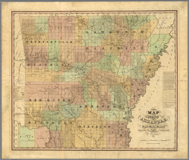
Stebbins, Henry S.
Full Title
A new map of the state of Arkansas, constructed principally from the United States surveys exhibiting the counties, townships & sections by H.S. Tanner. Published by H.S. tanner, Philadelphia. Entered according to Act of Congress in ... 1839, by H.S. Tanner in ... Eastern District of Pennsylvania.
List No
7634.000
Note
An extremely rare map of Arkansas and the earliest large format map of the state, published less than 3 years after its admission to the Union on June 15, 1836. Tanner's map depicts the new state divided by the Survey of Public Lands into the "Lawrence," "Arkansas," "Fayetteville," and "Red River" Districts and further subdivided into its 30 original counties. The familiar grid of townships and sections imposed by the Survey of Public Lands dominates the mapthis closely matches a Map of Arkansas Surveying District published by the General Land Office later in 1839 and is evidence that Tanner used the most up-to-date sources. Overall, Arkansas settlement was strikingly sparse at this early date, with the total population still under 100,000 and heavily concentrated in the eastern counties. Of particular interest are Miller and Lafayette Counties in the far southwest, at the time the subject of a territorial dispute with the then-independent Republic of Texas. Here they are assigned a somewhat ambiguous status, depicted within Arkansas' borders but not included in the Arkansas Survey District. All of Miller was ceded to Texas when it became a state in 1845, but the county was later reconstituted from the western portion of Lafayette County. Hand colored map. Includes notes and legend. Shows state, county, township, and district boundaries, railroads and roads,Trails, canals, rivers, and topographical features such as prairies and swamps. Relief shown by hachures. Prime meridian is Washington.
Author
[Wilkes, Charles, United States Exploring Expedition]
Full Title
Island of Upolu, Samoan Group by the U.S. Ex.Ex. 1839.
List No
6999.000
Note
This sheet is a part of a loose set - See Pub Note below.
Author
Burr, David H., 1803-1875
Full Title
Map of the United States Of North America With parts of the Adjacent Countries, By David H. Burr. (Late Topographer to the Post Office.) Geographer to the House of Representatives of the U.S. John Arrowsmith. Entered ... July 10th, 1839, by David H. Burr ... District of Columbia.
List No
0104.001
Note
This is the "Map of the United States of North America..." from Burr's American Atlas which consists of 13 separate sheets dissected & mounted on linen. In full color by state, country, or region. In 8 sections mounted on linen. Label on back states "No. 1. United States."
Author
[Alaskan Boundary Tribunal, Tanner, Henry S.]
Full Title
(Facsimile) A Map of North America Constructed According to the Latest Information by H.S. Tanner (portion). 1839. Alaskan Boundary Tribunal, 1903. 14. Photo. Lith. by A. Hoen & Co. Baltimore, MD.
List No
0009.057
Note
Map tinted. Vignette in title block including Niagara Falls and Natural Bridge in Virginia with animals. Relief shown by hachures.
Author
Burr, David H., 1803-1875
Full Title
(Covers to) (The American Atlas).
List No
0104A
Author
Burr, David H., 1803-1875
Full Title
Map of Maine, New Hampshire, Vermont, Massachusetts, Rhode Island, and Connecticut. Exhibiting the Post Offices, Post Roads, Canals, Rail Roads, &c. By David H. Burr. (Late Topographer to the Post Office.) Geographer to the House of Representatives of the U.S. John Arrowsmith. Entered ... July 10th, 1839, by David H. Burr ... District of Columbia.
List No
0104.002
Note
In full color by county with states outlined. Postal routes by coach, stage, sulkey, cross, rail roads and canals shown. In 8 sections mounted on linen. Label on back states "No. 2. Maine, New Hampshire, Vermont, Massachusetts, Rhode Island, Connecticut."
Author
Burr, David H., 1803-1875
Full Title
Map of New York Exhibiting the Post Offices, Post Roads, Canals, Rail Roads, &c. By David H. Burr. (Late Topographer to the Post Office.) Geographer to the House of Representatives of the U.S. (with) City And County Of New-York Brooklyn, Williamsburg & Jersey City. John Arrowsmith. Entered ... July 10th, 1839, by David H. Burr ... District of Columbia.
List No
0104.003
Note
In full color by county. Map of New York City uncolored. Postal routes by coach, stage, sulkey, cross, rail roads and canals shown. In 8 sections mounted on linen. Label on back states "No. 3. New York."
Author
Burr, David H., 1803-1875
Full Title
Map of New Jersey And Pennsylvania Exhibiting the Post Offices, Post Roads, Canals, Rail Roads, &c. By David H. Burr. (Late Topographer to the Post Office.) Geographer to the House of Representatives of the U.S. John Arrowsmith. Entered ... July 10th, 1839, by David H. Burr ... District of Columbia.
List No
0104.004
Note
In full color by county. Postal routes by coach, stage, sulkey, cross, rail roads and canals shown. In 8 sections mounted on linen. Label on back states "No. 4. New Jersey, Pennsylvania."
Author
Burr, David H., 1803-1875
Full Title
Map of Virginia, Maryland and Delaware Exhibiting the Post Offices, Post Roads, Canals, Rail Roads, &c. By David H. Burr. (Late Topographer to the Post Office.) Geographer to the House of Representatives of the U.S. John Arrowsmith. Entered ... July 10th, 1839, by David H. Burr ... District of Columbia.
List No
0104.005
Note
In full color by county. Postal routes by coach, stage, sulkey, cross, rail roads and canals shown. In 8 sections mounted on linen. Label on back states "No. 5. Delaware, Maryland, Virginia."
Author
Burr, David H., 1803-1875
Full Title
Map of North And South Carolina Exhibiting the Post Offices, Post Roads, Canals, Rail Roads, &c. By David H. Burr. (Late Topographer to the Post Office.) Geographer to the House of Representatives of the U.S. John Arrowsmith. Entered ... July 10th, 1839, by David H. Burr ... District of Columbia.
List No
0104.006
Note
In full color by county. Postal routes by coach, stage, sulkey, cross, rail roads and canals shown. In 8 sections mounted on linen. Label on back states "No. 6. North & South Carolina."
Author
Burr, David H., 1803-1875
Full Title
Map of Georgia & Alabama Exhibiting the Post Offices, Post Roads, Canals, Rail Roads, &c. By David H. Burr. (Late Topographer to the Post Office.) Geographer to the House of Representatives of the U.S. John Arrowsmith. Entered ... July 10th, 1839, by David H. Burr ... District of Columbia.
List No
0104.007
Note
In full color by county. Postal routes by coach, stage, sulkey, cross, rail roads and canals shown. In 8 sections mounted on linen. Label on back states "No. 7. Georgia, Alabama."
Author
Burr, David H., 1803-1875
Full Title
Map of Florida Exhibiting the Post Offices, Post Roads, Canals, Rail Roads, &c. By David H. Burr. (Late Topographer to the Post Office.) Geographer to the House of Representatives of the U.S. John Arrowsmith. (with) inset map of Florida panhandle. Entered ... July 10th, 1839, by David H. Burr ... District of Columbia.
List No
0104.008
Note
In full color by county. Postal routes by coach, stage, sulkey, cross, rail roads and canals shown. In 8 sections mounted on linen. Label on back states "No. 8. Florida."
Author
Burr, David H., 1803-1875
Full Title
Map of Mississippi, Louisiana & Arkansas Exhibiting the Post Offices, Post Roads, Canals, Rail Roads, &c. By David H. Burr. (Late Topographer to the Post Office.) Geographer to the House of Representatives of the U.S. John Arrowsmith. Entered ... July 10th, 1839, by David H. Burr ... District of Columbia.
List No
0104.009
Note
In full color by county. Postal routes by coach, stage, sulkey, cross, rail roads and canals shown. In 8 sections mounted on linen. Label on back states "No. 9. Mississippi, Louisiana, Arkansas."
Author
Burr, David H., 1803-1875
Full Title
Map of Ohio And Indiana Exhibiting the Post Offices, Post Roads, Canals, Rail Roads, &c. By David H. Burr. (Late Topographer to the Post Office.) Geographer to the House of Representatives of the U.S. John Arrowsmith. Entered ... July 10th, 1839, by David H. Burr ... District of Columbia.
List No
0104.010
Note
In full color by county. Postal routes by coach, stage, sulkey, cross, rail roads and canals shown. In 8 sections mounted on linen. Label on back states "No. 10. Ohio, Indiana."
|