|
Author
Society for the Diffusion of Useful Knowledge (Great Britain)
Full Title
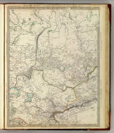
Western Siberia, Independent Tartary, Khiva, Bokhara &c. J. & C. Walker sculpt. Published by the Society for the Diffusion of Useful Knowledge, 59 Lincolns Inn Fields, Novr. 20th. 1838. (London: Chapman & Hall, 1844)
List No
0890.089
Note
Engraved map. Relief shown by hachures. Boundaries and lakes hand col. Two insets show continuations of map. Sources: Klaproth, Burnes, Piadischev and others.
Author
Society for the Diffusion of Useful Knowledge (Great Britain)
Full Title
Eastern Siberia. Engraved by J. & C. Walker. Published by the Society for the Diffusion of Useful Knowledge, 59 Lincolns Inn Fields, June 1st. 1838. (London: Chapman & Hall, 1844)
List No
0890.090
Note
Engraved map. Relief shown by hachures. Boundaries hand col. Sources: Piadischev, Lutke and others.
Author
Society for the Diffusion of Useful Knowledge (Great Britain)
Full Title
Siberia and Chinese Tartary. Engraved by J. & C. Walker. Published by the Society for the Diffusion of Useful Knowledge, 59 Lincolns Inn Fields, June 15th. 1838. (London: Chapman & Hall, 1844)
List No
0890.091
Note
Engraved map. Relief shown by hachures. Boundaries hand col. Sources: Piadischev and J. Arrowsmith.
Author
Society for the Diffusion of Useful Knowledge (Great Britain)
Full Title
Bokhara, Cabool, Beloochistan &c. Engraved by J. & C. Walker. Published for the Society for the Diffusion of Useful Knowledge by Chapman & Hall, 186 Strand, Augst. 15th. 1838 (1844)
List No
0890.092
Note
Engraved map. Relief shown by hachures. Boundaries hand col.
Author
Society for the Diffusion of Useful Knowledge (Great Britain)
Full Title
South America sheet V. Patagonia. (with) Isle of Georgia. (with) The South Shetlands and Orkneys. Published under the superintendence of the Society for the Diffusion of Useful Knowledge. Engraved by J. & C. Walker. London, published by Chapman & Hall, 186 Strand, April 2nd, 1838. (1844) Printed by J. & C. Walker.
List No
0890.152
Note
Engraved map. Relief shown by hachures and spot heights. Boundaries hand col. Covers also the Falkland Islands. David Rumsey Collection copy incorrectly bound in atlas as no. 154 (should be 153)
Author
Society for the Diffusion of Useful Knowledge (Great Britain)
Full Title
The islands of New Zealand. Engraved by J. & C. Walker. Published by the Society for the Diffusion of Useful Knowledge, 59 Lincolns Inn Fields, Novr. 26th. 1838. (London: Chapman & Hall, 1844)
List No
0890.158
Note
Engraved map. Relief shown by hachures and spot heights. Coasts, lakes hand col.
Author
Society for the Diffusion of Useful Knowledge (Great Britain)
Full Title
The environs of Edinburgh. (Published under the superintendence of the Society for the Diffusion of Useful Knowledge). B.R. Davies sculpt. London, published by Baldwin & Cradock, 47 Paternoster Row, March 1838. (London: Chapman & Hall, 1844)
List No
0890.175
Note
Engraved map. Hand col. Relief shown by hachures and spot heights.
Author
Society for the Diffusion of Useful Knowledge (Great Britain)
Full Title
Stockholm. 1838. Published under the superintendence of the Society for the Diffusion of Useful Knowledge. Drawn by W.B. Clarke, archt. Engraved by B.R. Davies, 16 George Str., London University. Published by Baldwin & Cradock, Paternoster Row, July 1, 1836 (sic). (London: Chapman & Hall, 1844)
List No
0890.203
Note
Engraved map. Relief shown by hachures. Hand col. Inset: View of Stockholm from the Island of Langholmen.
Author
Society for the Diffusion of Useful Knowledge (Great Britain)
Full Title
Venice. Venezia. Venedig. Drawn by W.B. Clarke. Engraved by B.R. Davies, 16 George Street, Euston Squ. Published by the Society for the Diffusion of Useful Knowledge, 59 Lincoln's Inn Fields, July 15, 1838. (London: Chapman & Hall, 1844)
List No
0890.207
Note
Engraved map on 2 sheets. Hand col. Insets: Plan of the environs of Venice showing the lagunes, &c. &c. &c. -- View of the Mint, St. Mark's Church, the Palace, &c. Includes drawings of 12 building and other structure facades.
Author
[Andriveau-Goujon, J., Soulier, E.]
Full Title
(Covers to) Atlas Elementaire Simplifie De Geographie Ancienne Et Moderne, Par E. Soulier (De Sauve), Professeur, Et J. Andriveau-Goujon. Approuve par le Conseil royal de l'Universite de France ... Paris. Chez Andriveau-Goujon, Geographe-Editeur, Rue Du Bac, 17.
List No
0940A
Note
Date is estimate. Bound in teal blue marbled paper covered boards with a green leather spine embossed with "Atlas De Geographie" in gilt.
Author
[Andriveau-Goujon, J., Soulier, E]
Full Title
(Title Page to) Atlas Elementaire Simplifie De Geographie Ancienne Et Moderne, Par E. Soulier (De Sauve), Professeur, Et J. Andriveau-Goujon. Approuve par le Conseil royal de l'Universite de France ... Paris. Chez Andriveau-Goujon, Geographe-Editeur, Rue Du Bac, 17.
List No
0940B
Author
[Andriveau-Goujon, J., Soulier, E.]
Full Title
Atlas Elementaire Simplifie. Publie par J. Andriveau-Goujon.
List No
0940.001
Note
Several diagrams showing planetary relationships.
Author
[Andriveau-Goujon, J., Soulier, E.]
Full Title
Notions Preliminaires. Atlas Elementaire Simplifie. Publie par J. Andriveau-Goujon.
List No
0940.002
Note
Shows map projections, symbols, longitude, latitude, and molten core of the earth.
Author
[Andriveau-Goujon, J., Soulier, E.]
Full Title
Mappemonde en Deux Hemispheres. Atlas Elementaire Simplifie. Publie par J. Andriveau-Goujon.
List No
0940.003
Note
Shows western and eastern hemispheres, tables of principal mountains, small map of polar hemispheres, and triangular diagram of the five parts of the world: Europe, Oceania, Africa, America, and Asia. Date is estimate. Prime meridian Paris. Relief shown by shading.
Author
[Andriveau-Goujon, J., Soulier, E.]
Full Title
Europe. Atlas Elementaire Simplifie. Publie par J. Andriveau-Goujon. E. Soulier del. A Paris, chez Andriveau-Goujon, Editeur, Rue du Bac, No. 17.
List No
0940.004
Note
Date is estimate. Prime meridian Paris. Relief shown by hachures. Mountain diagram across bottom of map.
Author
[Andriveau-Goujon, J., Soulier, E.]
Full Title
Asie. Atlas Elementaire Simplifie. Publie par J. Andriveau-Goujon. E. Soulier del. A Paris, chez Andriveau-Goujon, Editeur, Rue du Bac, No. 17.
List No
0940.005
Note
Relief shown by hachures. Paris prime meridian. Diagram of mountains across bottom of map.
Author
[Andriveau-Goujon, J., Soulier, E.]
Full Title
Afrique. Atlas Elementaire Simplifie. Publie par J. Andriveau-Goujon. E. Soulier del. A Paris, chez Andriveau-Goujon, Editeur, Rue du Bac, No. 17.
List No
0940.006
Note
Relief shown by hachures. Paris prime meridian. Includes unexplored regions. Diagram of mountains across bottom of map.
Author
[Andriveau-Goujon, J., Soulier, E.]
Full Title
Oceanie. Atlas Elementaire Simplifie. Publie par J. Andriveau-Goujon. E. Soulier del. A Paris, chez Andriveau-Goujon, Editeur, Rue du Bac, No. 17.
List No
0940.007
Note
Relief shown by hachures. Paris prime meridian. Diagram of mountains across bottom of map.
Author
[Andriveau-Goujon, J., Soulier, E.]
Full Title
Amerique du Nord. Atlas Elementaire Simplifie. Publie par J. Andriveau-Goujon. E. Soulier del. A Paris, chez Andriveau-Goujon, Editeur, Rue du Bac, No. 17. (inset) Aleutian Islands.
List No
0940.008
Note
Relief shown by hachures. Paris prime meridian. Diagram of mountains across bottom of map.
Author
[Andriveau-Goujon, J., Soulier, E.]
Full Title
Amerique du Sud. Atlas Elementaire Simplifie. Publie par J. Andriveau-Goujon. E. Soulier del. A Paris, chez Andriveau-Goujon, Editeur, Rue du Bac, No. 17.
List No
0940.009
Note
Relief shown by hachures. Paris prime meridian. Diagram of mountains along left (west) side of map.
Author
[Andriveau-Goujon, J., Soulier, E.]
Full Title
France. Atlas Elementaire Simplifie. Publie par J. Andriveau-Goujon. E. Soulier del. A Paris, chez Andriveau-Goujon, Editeur, Rue du Bac, No. 17.
List No
0940.010
Note
Relief shown by hachures. Paris prime meridian. Diagram of mountains across bottom of map. List of provinces keyed to map. Colored by province with department boundaries shown.
Author
[Andriveau-Goujon, J., Soulier, E.]
Full Title
France. Atlas Elementaire Simplifie. Publie par J. Andriveau-Goujon. E. Soulier del. A Paris, chez Andriveau-Goujon, Editeur, Rue du Bac, No. 17.
List No
0940.011
Note
Relief shown by hachures. Paris prime meridian. Diagram of mountains shown across bottom of map. List of provinces keyed to map. Colored by department.
Author
[Andriveau-Goujon, J., Soulier, E.]
Full Title
Migrations des Peuples. Atlas Elementaire Simplifie. Publie par J. Andriveau-Goujon. E. Soulier del. A Paris, chez Andriveau-Goujon, Editeur, Rue du Bac, No. 17. Revu par Mr. Hase, Membre de l'Institut.
List No
0940.012
Note
Relief shown by hachures. Shows routes and settlement locations of various peoples in Europe, North Africa, and Asia. Contains short explanatory text.
Author
[Andriveau-Goujon, J., Soulier, E.]
Full Title
Anciens Empires Jusqua Alexandre. Atlas Elementaire Simplifie. Publie par J. Andriveau-Goujon. E. Soulier del. A Paris, chez Andriveau-Goujon, Editeur, Rue du Bac, No. 17. Revu par Mr. Hase, Membre de l'Institut.
List No
0940.013
Note
Relief shown by hachures. Paris prime meridian. Shows in color various kingdoms and empires, listed and dated.
Author
[Andriveau-Goujon, J., Soulier, E.]
Full Title
Egypte, Syrie, Asie Mineure. (inset) Palestine. Atlas Elementaire Simplifie. Publie par J. Andriveau-Goujon. E. Soulier del. A Paris, chez Andriveau-Goujon, Editeur, Rue du Bac, No. 17. Revu par Mr. Hase, Membre de l'Institut.
List No
0940.014
Note
Relief shown by hachures. Paris prime meridian.
Author
[Andriveau-Goujon, J., Soulier, E.]
Full Title
Grece et ses Colonies. (inset) Mediterranean region. (inset) Environs d'Athenes. Atlas Elementaire Simplifie. Publie par J. Andriveau-Goujon. E. Soulier del. A Paris, chez Andriveau-Goujon, Editeur, Rue du Bac, No. 17. Revu par Mr. Hase, Membre de l'Institut.
List No
0940.015
Note
Relief shown by hachures. Paris prime meridian. Inset of the Mediterranean shows seven clusters of labeled colonies.
Author
[Andriveau-Goujon, J., Soulier, E.]
Full Title
Gaule. Italie Ancienne. Atlas Elementaire Simplifie. Publie par J. Andriveau-Goujon. E. Soulier del. A Paris, chez Andriveau-Goujon, Editeur, Rue du Bac, No. 17. Revu par Mr. Hase, Membre de l'Institut.
List No
0940.016
Note
Relief shown by hachures. Paris prime meridian.
Author
[Andriveau-Goujon, J., Soulier, E.]
Full Title
Empire Romain. Atlas Elementaire Simplifie. Publie par J. Andriveau-Goujon. E. Soulier del. A Paris, chez Andriveau-Goujon, Editeur, Rue du Bac, No. 17. Revu par Mr. Hase, Membre de l'Institut.
List No
0940.017
Note
Relief shown by hachures. Paris prime meridian. Shows divisions of the empire.
Author
[Andriveau-Goujon, J., Soulier, E.]
Full Title
Invasion des Barbares. Atlas Elementaire Simplifie. Publie par J. Andriveau-Goujon. E. Soulier del. A Paris, chez Andriveau-Goujon, Editeur, Rue du Bac, No. 17. Revu par Mr. Hasf, Membre de l'Institut.
List No
0940.018
Note
Relief shown by hachures. Paris prime meridian. Shows dated invasion routes of the Barbarians.
Author
[Andriveau-Goujon, J., Soulier, E.]
Full Title
L'Europe au Temps des Croisades. (inset) Antioch. (inset) Jerusalem en 1099. Atlas Elementaire Simplifie. Publie par J. Andriveau-Goujon. E. Soulier del. A Paris, chez Andriveau-Goujon, Editeur, Rue du Bac, No. 17. Revu par Mr. Hase, Membre de l'Institut.
List No
0940.019
Note
Relief shown by hachures. Paris prime meridian. Shows routes of the 1st, 3rd, 4th, 7th, and 8th Crusades. Table of structures keyed to inset maps of Antioch and Jerusalem.
Author
[Andriveau-Goujon, J., Soulier, E.]
Full Title
Europe Historique. Atlas Elementaire Simplifie. Publie par J. Andriveau-Goujon. E. Soulier del. A Paris, chez Andriveau-Goujon, Editeur, Rue du Bac, No. 17. Revu par Mr. Hase, Membre de l'Institut.
List No
0940.020
Note
Four maps on one sheet showing Europe in 800 (Charlemagne), 1556 (Charles VIIIth), 1789, and 1812. Relief shown by hachures.
Author
[Andriveau-Goujon, J., Soulier, E.]
Full Title
France Historique. Atlas Elementaire Simplifie. Publie par J. Andriveau-Goujon. E. Soulier del. A Paris, chez Andriveau-Goujon, Editeur, Rue du Bac, No. 17. Revu par Mr. Hase, Membre de l'Institut.
List No
0940.021
Note
Relief shown by hachures. Nine maps on one sheet each showing France and portions of surrounding countries in A.D. 481, 507, 888, 987, 1152, 1422, 1485, 1648, and 1713.
Author
[Andriveau-Goujon, J., Soulier, E.]
Full Title
Hollande et Belgique. Suede et Danemark. (inset) Islande. (inset) Iles Feroe. Atlas Elementaire Simplifie. Publie par J. Andriveau-Goujon. A Paris, chez Andriveau-Goujon, Editeur, Rue du Bac, No. 17.
List No
0940.022
Note
Relief shown by hachures. Two maps on one sheet.
Author
[Andriveau-Goujon, J., Soulier, E.]
Full Title
Russie D'Europe. Empire Russe. Atlas Elementaire Simplifie. Publie par J. Andriveau-Goujon. A Paris, chez Andriveau-Goujon, Editeur, Rue du Bac, No. 17.
List No
0940.023
Note
Relief shown by hachures. Paris prime meridian. Two maps on one sheet. Second map in polar projection.
Author
[Andriveau-Goujon, J., Soulier, E.]
Full Title
Iles Britanniques. (inset) Iles Shetland. Atlas Elementaire Simplifie. Publie par J. Andriveau-Goujon. A Paris, chez Andriveau-Goujon, Editeur, Rue du Bac, No. 17.
List No
0940.024
Note
Relief shown by hachures. Paris prime meridian.
Author
[Andriveau-Goujon, J., Soulier, E.]
Full Title
Etats Secondaires de L'Allemagne. Atlas Elementaire Simplifie. Publie par J. Andriveau-Goujon. E. Soulier del. A Paris, chez Andriveau-Goujon, Editeur, Rue du Bac, No. 17.
List No
0940.025
Note
Relief shown by hachures. Paris prime meridian. List of 39 states of Allemagne, keyed to map.
Author
[Andriveau-Goujon, J., Soulier, E.]
Full Title
Monarchie Prussienne. Atlas Elementaire Simplifie. Publie par J. Andriveau-Goujon. E. Soulier del. A Paris, chez Andriveau-Goujon, Editeur, Rue du Bac, No. 17.
List No
0940.026
Note
Relief shown by hachures. Paris prime meridian.
Author
[Andriveau-Goujon, J., Soulier, E.]
Full Title
Empire D'Autriche. Atlas Elementaire Simplifie. Publie par J. Andriveau-Goujon. E. Soulier del. A Paris, chez Andriveau-Goujon, Editeur, Rue du Bac, No. 17.
List No
0940.027
Note
Relief shown by hachures. Paris prime meridian.
Author
[Andriveau-Goujon, J., Soulier, E.]
Full Title
Suisse et Etats Sardee. (inset) Sardaigne. Atlas Elementaire Simplifie. Publie par J. Andriveau-Goujon. A Paris, chez Andriveau-Goujon, Editeur, Rue du Bac, No. 17.
List No
0940.028
Note
Relief shown by hachures. Paris prime meridian. Shows Swiss cantons and Italian states.
Author
[Andriveau-Goujon, J., Soulier, E.]
Full Title
Atlas Elementaire Simplifie. Publie par J. Andriveau-Goujon. E. Soulier del. A Paris, chez Andriveau-Goujon, Editeur, Rue du Bac, No. 17.
List No
0940.029
Note
Relief shown by hachures. Paris prime meridian. List of Spanish provinces and divisions in 1833, keyed to map.
Author
[Andriveau-Goujon, J., Soulier, E.]
Full Title
Italie. Atlas Elementaire Simplifie. Publie par J. Andriveau-Goujon. A Paris, chez Andriveau-Goujon, Editeur, Rue du Bac, No. 17.
List No
0940.030
Note
Relief shown by hachures. Paris prime meridian.
Author
[Andriveau-Goujon, J., Soulier, E.]
Full Title
Empire Ottoman. (inset) Grece. Atlas Elementaire Simplifie. Publie par J. Andriveau-Goujon. A Paris, chez Andriveau-Goujon, Editeur, Rue du Bac, No. 17.
List No
0940.031
Note
Relief shown by hachures. Paris prime meridian.
Author
Tanner, Henry S.
Full Title
Texas.
List No
0980.039
Author
[Woerl, Joseph Edmund (1803-1865), Herder, Bartholomew]
Full Title
(Covers to) Atlas von Central Europa : Enthaltend das Konigreich Frankreich ; die nordstl. Provinzen von Spanien, die Konigreiche der Niederlande und Belgien nebst dem Grossherzogthum Luxemburg, die Konigreiche Preussen, Hannover, Danemark, Sachsen, Bayern, Wurttemberg ... Entworfen im masstabe 1:500,000 von Dr. J.E. Woerl. Freiburg im Breisgau. Herder'sche Verlagshandlung.
List No
10094.001
Note
Atlas of Central Europe by Joseph Edmund Woerl in 60 sheets. each 45x52 or smaller, dissected into 6 sections, backed with linen, folded and placed in cardboard case 25x20, with title "Karte von Central-Europa" in gold on spine. Sheet 8 includes Title with text, inset map, and tables of population of provinces, towns and islands. Maps showing roads, railroads, cities, towns, landmarks, canals, fortifications, forests, rivers and mountains. Relief shown by hachures. Depth shown by bathymetric lines and soundings. Includes inset maps: Environs de Paris -- Plan de Strasbourg -- Plan de Lyon -- Plan de Bordeaux -- Plan de Rouen -- [Bruxelles-Louvain-Nivelles] -- Plan de Nantes -- Plan d'Orléans -- Contorni di Milano -- Planta di Firenze -- Planta topografica della città di Roma.Includes a separate index sheet "Assemblage zur Karte von Central - Europe. Masstab 1:500,000. Verlag von Herder in Freiburg I. B." Maps are the earliest of two-color lithography. As late as 1870 this atlas rendered important service to the German army, It is also an outstanding example of early lithographic map printing. Woerl seems to have pioneered a method of using color lithography, he used a red lithographic stone for a second overlay printing and may have used a unique combination of lithography and engraving to produce these maps. Imprint of some maps are in French. Library lacks sheets 26 and 59.
Author
[Woerl, Joseph Edmund (1803-1865), Herder, Bartholomew, Weiss, J.H.]
Full Title
La Savoie : Geneve. Dressee par Woerl et grave sous sa direction. Lithographie de B. Herder a Freiburg en Brisgau. (to accompany) Atlas von Central Europa. Entworfen im masstabe 1:500,000 von Dr. J.E. Woerl. Freiburg im Breisgau. Herder'sche Verlagshandlung.
List No
10094.003
Note
Color lithography map. Show roads, railroads, counties, cities, towns, landmarks, canals, fortifications, rivers, forests and mountains. Relief shown by hachures.
Author
[Woerl, Joseph Edmund (1803-1865), Herder, Bartholomew, Weiss, J.H.]
Full Title
Milano. Entworfen und bearbeitet von Woerl, gestochen unter seiner Leitung. Lithographie von B. Herder a Freiburg en Breisgau. (to accompany) Atlas von Central Europa. Entworfen im masstabe 1:500,000 von Dr. J.E. Woerl. Freiburg im Breisgau. Herder'sche Verlagshandlung.
List No
10094.004
Note
Color lithography map. Show roads, railroads, counties, cities, towns, landmarks, canals, fortifications, rivers, forests and mountains. Relief shown by hachures.
Author
[Woerl, Joseph Edmund (1803-1865), Herder, Bartholomew, Weiss, J.H.]
Full Title
Venezia. Entworfen und bearbeitet von Woerl, gestochen unter seiner Leitung. Lithographie von B. Herder a Freiburg en Breisgau. (to accompany) Atlas von Central Europa. Entworfen im masstabe 1:500,000 von Dr. J.E. Woerl. Freiburg im Breisgau. Herder'sche Verlagshandlung.
List No
10094.005
Note
Color lithography map. Show roads, railroads, counties, cities, towns, landmarks, canals, fortifications, rivers, forests and mountains. Relief shown by hachures. Depth shown by bythymetic contours and soundings.
Author
[Woerl, Joseph Edmund (1803-1865), Herder, Bartholomew, Weiss, J.H.]
Full Title
Marseille - Nizza. Dressee par Woerl et grave sous sa direction. Lithographie de B. Herder a Freiburg en Brisgau. (to accompany) Atlas von Central Europa. Entworfen im masstabe 1:500,000 von Dr. J.E. Woerl. Freiburg im Breisgau. Herder'sche Verlagshandlung.
List No
10094.006
Note
Color lithography map. Show roads, railroads, counties, cities, towns, landmarks, canals, fortifications, rivers, forests and mountains. Relief shown by hachures.
Author
[Woerl, Joseph Edmund (1803-1865), Herder, Bartholomew, Weiss, J.H.]
Full Title
Genova. Entworfen und bearbeitet von Woerl, gestochen unter seiner Leitung. Lithographie von B. Herder a Freiburg en Breisgau. (to accompany) Atlas von Central Europa. Entworfen im masstabe 1:500,000 von Dr. J.E. Woerl. Freiburg im Breisgau. Herder'sche Verlagshandlung. (inset) Contorni di Milano.
List No
10094.007
Note
Color lithography map. Show roads, railroads, counties, cities, towns, landmarks, canals, fortifications, rivers, forests and mountains. Relief shown by hachures. Depth shown by bathymetric contours and soundings.
Author
[Woerl, Joseph Edmund (1803-1865), Herder, Bartholomew, Weiss, J.H.]
Full Title
Florenz. Entworfen und bearbeitet von Woerl, gestochen unter seiner Leitung. Lithographie von B. Herder a Freiburg en Breisgau. (to accompany) Atlas von Central Europa. Entworfen im masstabe 1:500,000 von Dr. J.E. Woerl. Freiburg im Breisgau. Herder'sche Verlagshandlung. (inset) Pianta di Firenze. 1:30,000.
List No
10094.008
Note
Color lithography map. Show roads, railroads, counties, cities, towns, landmarks, canals, fortifications, rivers, forests and mountains. Relief shown by hachures. Depth shown by bathymetric contours and soundings.
|