|
Author
[Depot General de la Marine, Beautemps-Beaupré, Charles François, 1766-1854]
Full Title
Carte Des Cotes De France (Partie Comprise Entre L'Ile D'Yeu Et La Pointe Des Baleines)
List No
15934.155
Note
Hydrographie Française 4
Author
[Depot General de la Marine, Beautemps-Beaupré, Charles François, 1766-1854]
Full Title
Carte Des Cotes De France (Pwetuis-Breton, D'Antioche Et Pertuis De Maumusson
List No
15934.159
Note
Hydrographie Française 4
Author
[Depot General de la Marine, Beautemps-Beaupré, Charles François, 1766-1854]
Full Title
Carte Particuliere Des Cotes De France (Entree Du Peruis D'Antioche)
List No
15934.164
Note
Hydrographie Française 4
Author
[Depot General de la Marine, Beautemps-Beaupré, Charles François, 1766-1854]
Full Title
Carte Particuliere Des Cotes De France (Interieur Du Pertuis D'Antioche, Environs De La Rochelle, Rade Des Basques, Rade De L'Ile D'Aix, Rade Des Trousses, Entree De La Charente)
List No
15934.165
Note
Hydrographie Française 4
Author
[Depot General de la Marine, Beautemps-Beaupré, Charles François, 1766-1854]
Full Title
Carte Particuliere Des Cotes De France (Pertuis De Maumusson)
List No
15934.169
Note
Hydrographie Française 4
Author
[Depot General de la Marine, Le Saulnier de Vauhello, Hippolyte, 1796-1858]
Full Title
Carte Generale Des Sondes D'Atterages Des Cotes Occidentales De France Et Des Cotes Septentrionales D'Espagne
List No
15934.094
Note
Hydrographie Française 3
Author
[Depot General de la Marine, MacKenzie, M.M., Spence, Graeme, Thomas, George]
Full Title
Carte Des Entrees De La Tamise
List No
15934.053
Note
Hydrographie Française 2
Author
[Depot General de la Marine, Spence, Graeme, Thomas, George]
Full Title
Carte De La Rade Des Dunes
List No
15934.054
Note
Hydrographie Française 2
Author
[Depot General de la Marine, Løvenørn, Poul]
Full Title
Carte Reduite Des Cotes Orientales D'Islande Depuuis Vapna - Fiord jusqu'au Cap Ingolfs - Hofde
List No
15934.011
Note
Hydrographie Française 1
Author
[Depot General de la Marine, Løvenørn, Poul]
Full Title
Carte Reduite Des Cotes Orientales D'Islande Depuuis Cap Ingolfs - Hofde jusqu'au Cap Reikianaes
List No
15934.012
Note
Hydrographie Française 1
Author
Berghaus, Heinrich, 1797-1884
Full Title
11. Karte von der Insel Sumatra.
List No
15177.032
Note
With six inset maps: Die Lacca Diven, Die Male Diven, Tschagos Archipelag, Keeling od. Borneo-Korallen Inseln, Indel Singapore, and Bangka Strasse.
Author
Berghaus, Heinrich, 1797-1884
Full Title
8. Hinterindien Dem Sir Francis Hamilton.
List No
15177.033
Author
[Fer, Nicolas de, 1646-1720, Bernard, J.F.]
Full Title
L'Europe Suivant les Nouvelles Observations De M.rs De L'Academie Royale Des Siences
List No
15793.000
Author
Berghaus, Heinrich, 1797-1884
Full Title
2. Karte von China und Japan. den Manen D"Anville's Ind Klapproth's.
List No
15177.031
Note
Our physical copy. Compare to digital copy from Library of Congress - there are substantial differences in the colored boundary lines between political areas but no changes in the engraving that we have found. Relief shown by hachures. - In lower right: Gest. v. Mädel II u. s Sch. - From Berghaus's Atlas von Asia. - Prime meridians: Paris and Greenwich. - In upper left: Berghaus's Atlas von Asia. - Includes chart of geographic terms in 9 languages. - In upper right: no. 2. ( and 44 added)
Author
Berghaus, Heinrich, 1797-1884
Full Title
14. Reduzirte Karte vom Chinesischen Meere; 1stes oder Sudliches Blatt. (Reduced Map of the China Sea; 1st or southern leaf..)
List No
15177.030
Note
Inset map of the Gulf of Siam.
Author
Berghaus, Heinrich, 1797-1884
Full Title
5. Karte von Syrien: den Manen Jacotin’s und Burckhardt’s gewidmet.
List No
15177.028
Note
Relief shown by hachures. Depths shown by soundings. Includes 11 small views of places in Palestine and 2 in Lebanon. Two inset maps of Syria and Arabia Petraea (scale 1:1,800,000).
Author
Berghaus, Heinrich, 1797-1884
Full Title
(Covers to) 5. Karte von Syrien: den Manen Jacotin’s und Burckhardt’s gewidmet.
List No
15177.029
Author
[American Colonization Society, Gurley, Ralph Randolph]
Full Title
(Title page to) Address of the Managers of the American Colonization Society, to the People of the United States. Adopted at their Meeting, June 19, 1832. “What ought to be done, can be done.”
List No
15264.001
Author
[American Colonization Society, Gurley, Ralph Randolph]
Full Title
Colony of Liberia, On The West Coast of Africa. (Inset) Plan of the Town of Monrovia.
List No
15264.002
Author
[American Colonization Society, Gurley, Ralph Randolph]
Full Title
(Composite text page to) Address of the Managers of the American Colonization Society, to the People of the United States. Adopted at their Meeting, June 19, 1832. “What ought to be done, can be done.”
List No
15264.003
Author
Desjardins, Constant
Full Title
Tableau Comparatif de la hauteur des principales montagnes et lieux remarquables du globe au dessus du niveau de la mer, dressé et lithographié par Dejardins (chef d’ une maison d’ education) avec hauteur de différentes villes au dessus de niveau de la mer, Montagnes de l’ Europe, Australie, Asie.- Munich, C. Desjardins, 1832
List No
15192.000
Author
Berghaus, Heinrich, 1797-1884
Full Title
(Title/Advertisement to) Atlas von Asien
List No
15177.001
Note
This advertisement for the Atlas von Asien appeared in the 1834 edition of Bericht uber Stieler's Hand-Atlas.
Author
Berghaus, Heinrich, 1797-1884
Full Title
2. Karte von China und Japan. den Manen D"Anville's Ind Klapproth's.
List No
15177.002
Note
Digital copy only from the Library of Congress. Relief shown by hachures. - In lower right: Gest. v. Mädel II u. s Sch. - From Berghaus's Atlas von Asia. - Prime meridians: Paris and Greenwich. - In upper left: Berghaus's Atlas von Asia. - Includes chart of geographic terms in 9 languages. - In upper right: no. 2.
Author
Berghaus, Heinrich, 1797-1884
Full Title
6. Arabia und das Nil-Land Den Manen Karsten Niebuhr's und den hochverdienten forschen.
List No
15177.003
Note
"Rare Printed Map Showing One of the Earliest Appearances of the Names Kuwait, Dubai and Abu Dhabi Striking, rare map of the Arabian Peninsula and the east coast of Africa with the River Nile. This is one of the earliest printed maps to use a modern name for Kuwait (El Koueit Grahe), Dubai (Debai) and Abu Dhabi (Abuthhubi). The map extends west to east from the “Lybian Desert” to “Ras-el-Had”. From north to south it stretches from the Nile Delta to “Lake Tanzania”. Several inset plans are included, such as Jeddah, Mecca and Medina. There is also a trompe-l'oeil of the caravan route from Jeddah to Mecca and on to Taife. The map names Bahrain and Riyadh. Qatar is shown as Bahran. There are several red pencil highlights at various places on the map, including Bahrain, Basra, Kuwait, and on the Sinai Peninsula. Those marks in the Persian Gulf indicate key points: Basra (most emphatic with an X), then Kuwait, Bushehr, and Bahrain (each with a +). The Sinai marks are more idiosyncratic and most likely follow the travels of German explorer and naturalist Eduard Rüppell, who visited the Sinai Peninsula twice. However, they could also refer to areas of trade or political interest, or, if they were made later in the nineteenth century, to the explorations of the American officers invited to Egypt by Khedive Ismail. Of these Sinai marks, al-Arish is the most emphatically made (with an X). Also marked is Nakhl, the most important station on the Suez-Aqaba road (but without an X), then Thamud, a district not on the same road as Nakhl (X). Finally, marked is a nameless area east of Lake Timsah (with an intriguing X). Sources for the map: European exploration of the Arabian Peninsula The map is based on the work of Carsten Niebuhr, a German mathematician and cartographer who participated in the Royal Danish Arabia Expedition (1761-7). As part of that expedition, he visited Cairo, Sinai, sailed the Red Sea, then went to Jeddah and Sana, Yemen. Niebuhr had trouble adapting to the climate, but his woes were nothing compared to his fellows, who died en route. By the time the voyage made it to Bombay, Niebuhr was the only surviving member. He returned via Muscat, Bushire, Shiraz, and Persepolis, where he made copies of cuneiform inscriptions that helped to decipher the ancient script. He finished the trip with visits to Cyprus, Palestine, and Constantinople before returning to Copenhagen. Thanks to his careful observations, Niebuhr produced a series of small-scale maps of the areas he visited, as well nearly 30 town plans which constituted the most extensive cartographic coverage of the area by a European to date. Additional information for the map came from the explorations of L.G. Ehrenberg and Eduard Rüppell, two zoologists who extensively explored the Red Sea and Ethiopian region. L.G. Ehrenberg refers to Christian Gottfried Ehrenberg, a German explorer and one of the most famous scientists of his time. After his early work on fungi, Ehrenberg paired with Wilhelm Hemprich to journey across the Middle East collecting animal and plant specimens. From 1820-25 they were in Egypt, the Libyan Desert, Sudan, the Nile River Valley, the north coasts of the Red Sea, Syria, and parts of what was then Arabia and Abyssinia. During his later career, he pioneered the study of microscopic organisms. Eduard Rüppell was a third German man of science who journeyed to the Middle East. After a visit to Sinai in 1817, Rüppell abandoned the family business of banking to pursue natural history. In 1821, he returned to Sinai to collect specimens; he and his surgeon assistant, Michael Hey, were the first Europeans to reach the Gulf of Aqaba. They later traveled up the Nile to Nubia and then Cairo and then into parts of Ethiopia. Rüppell returned to Africa again in 1830, when he became the first naturalist to cross the entirety of Ethiopia. Like Ehrenberg, many species are today named after Rüppell which were gathered on these travels. Their travels also clearly influenced cartography, as this item shows. Political control of the Arabian Peninsula and eastern Africa in the early-nineteenth century The first Saudi state was established in 1744 and lasted until 1818, when it was taken over by the Ottoman Viceroy of Egypt, Muhammed Ali Pasha. The Al Saud family continued to control the central Najd region of the peninsula from 1824. This area is outlined in green on the map and is located in the interior of the peninsula. From 1818 to 1845, when this map was made, the Arabian Peninsula was administered by Egypt as part of the Ottoman Empire. In 1820, Muhammad Ali Pasha ordered the conquest of eastern Libya. Ali wished to extend his power southward, into Sudan, and to control the caravan route to the Red Sea and the gold mines in Sennar. Muhammed Ali’s son, Ismail, led a force of roughly 4500 men from Cairo in July of 1820. Nubia was not able to mount an effective defense, Shagia Arabs beyond the province of Dongola were defeated, and Sennar was destroyed. Although nominally part of the Ottoman Empire since 1554, between 1821 and 1841, Muhammad Ali came to control Yemen and the horn of Africa. After the Egyptians withdrew from the Yemeni coast in 1841, Haj Ali Shermerki, a Somali merchant, purchased executive rights over Zeila from the Egyptians. However, as this map was made in 1835, it still shows the Horn of Africa and Yemen under the control of Egypt. The map provides an important, early, and authoritative delineation of the coasts of the Arabian Gulf which offers some of the earliest printed portrayals of Kuwait, Dubai, and Abu Dabai. It includes more than twenty toponyms along the coast of Qatar (in this map labeled "Bahran"). The map shows the Hawar Islands off the west coast of Qatar, Doha Harbor, as well as a large reef off the eastern coast. Finally, the inclusion of the red markings show that this map was important reference material to a previous owner and it would make an important addition to any collection of the Middle East or the Arabian Peninsula. Reference Wolfgang Klausewitz, “Frankfurt versus Berlin: The Red Sea explorers Wilhelm Hemprich, Christian Ehrenberg and Eduard Rüppell,” Zoology in the Middle East 27, no. 1 (2002): 7-12." (Ruderman, 2022)
Author
Berghaus, Heinrich, 1797-1884
Full Title
7. General Karte von Vorderindien zur Übersicht der Hauptverhältnisse den Manen James'Rennell dargebrach
List No
15177.004
Note
Digital copy only courtesy of Barry Ruderman maps.
Author
Berghaus, Heinrich, 1797-1884
Full Title
9. Karte von Assam und seinen Nachbar-Ländern
List No
15177.005
Note
"Fine large format map of Assam and neighboring regions, printed in November 1834, Sheet no.9, published in Berghaus' rare Atlas von Asia. Particularly interesting are the early details on Bhutan, Firstly lower left are "Ansichten von Bhotan Gegenden" Seven unusual engraved views of Bhutan from the early 19th century. Another detail is 'Supplement Zho Bhotan'. Includes parts of Myanmar, Bhutan, Arunachal, Meghalaya, Manipur, Nagaland and Tibet, extending the western part of Yunan Province in China and Tibet. The map is perhaps the largest format atlas map of the 19th Century to focus on this region, doing so in the meticulous style of Berghaus and Justus Perthes, the publisher. The map provides both geographical and topographical details, several profile maps illustrating the heights of mountain ranges. A scarce map. According to a source only 515 charts were printed*. Reference *Lietz, Rudolf J.H. Insulae Indiae Orientalis 2018, Chapter 5 The Berghaus maps ... page 66." (Wattis Fine Art, 2022)
Author
Berghaus, Heinrich, 1797-1884
Full Title
16. Die chinesische Küste der Provinz Küste der Provinz Kuang-tung zu beiden Seiten des Meridians von Macao ...
List No
15177.006
Note
Digital copy only from Library of Congress. Prime Meridian: Macao. - With 2 subsections: Macao. Harlem's Bay &c., &c. - With 5 views: Tiger Island. Bocca Tigris. Pic By Lantao. Macao. Camoen's grotto. - With 17 settings. - With Erl. on d. card field. Responsibility: According to the recordings of Captains Daniel Ross, Horsburgh, Maughan, Newell, Auber, Blakely, &c., &c. Engraved by H. Herzberg.
Author
Berghaus, Heinrich, 1797-1884
Full Title
17. Reduzirte Karte vom Sunda-/oder Borneo-Meere und den Strassen zur Verbindung dessselben mit dem Indischen und dem Chinesischen Meere, der Macasser-Strasse &e, zugleich als Karte von Djava, den kleinen Sunda-Inseln, Celebes, etc.,etc.
List No
15177.007
Note
12 views presented: View from the southern entrances of Gaspar Street, Salayer Streets from the west side, Tandjong Salatan, Two Brothers, Lombock Spades, Gross Solombo, Mount Bulu Comba, Moresses, Bali Peaks, Dwaalder, Gunong Api N.1e O, Views in Sunda Responsibility: the Kaiserl. Pruys. Dedicated by Berghaus to Admiral von Krusenstern as public proof of his deepest respect.
Author
Berghaus, Heinrich, 1797-1884
Full Title
19.(18) Karte vom Ural Gebirge. Gegründet auf die astronomischen Beobachtungen von Wischnewsky, Schubert, A. v. Humboldt, Ad. Erman, und auf handschriftliche Specialkarten
List No
15177.008
Note
Prime Meridian: Paris. - With 1 subtitle: Belaja Gora with surroundings. To: Rose, Gustav: Mineralogical-geognostic journey to the Urals, the Altai and the Caspian Sea.
Author
Berghaus, Heinrich, 1797-1884
Full Title
(Text page 1)
List No
15177.009
Note
This volume contains the text Berghaus wrote to accompanying the maps. 9 maps of the 15 are described here. See link below to full text of this volume.
Author
Berghaus, Heinrich, 1797-1884
Full Title
(Text page 2)
List No
15177.010
Note
This volume contains the text Berghaus wrote to accompanying the maps. 9 maps of the 15 are described here. See link below to full text of this volume.
Author
Berghaus, Heinrich, 1797-1884
Full Title
(Text page 3)
List No
15177.011
Note
This volume contains the text Berghaus wrote to accompanying the maps. 9 maps of the 15 are described here. See link below to full text of this volume.
Author
Berghaus, Heinrich, 1797-1884
Full Title
(Text page 4)
List No
15177.012
Note
This volume contains the text Berghaus wrote to accompanying the maps. 9 maps of the 15 are described here. See link below to full text of this volume.
Author
Berghaus, Heinrich, 1797-1884
Full Title
(Text page 5)
List No
15177.013
Note
This volume contains the text Berghaus wrote to accompanying the maps. 9 maps of the 15 are described here. See link below to full text of this volume.
Author
Berghaus, Heinrich, 1797-1884
Full Title
(Text page 6)
List No
15177.014
Note
This volume contains the text Berghaus wrote to accompanying the maps. 9 maps of the 15 are described here. See link below to full text of this volume.
Author
Berghaus, Heinrich, 1797-1884
Full Title
(Text page 7)
List No
15177.015
Note
This volume contains the text Berghaus wrote to accompanying the maps. 9 maps of the 15 are described here. See link below to full text of this volume.
Author
Berghaus, Heinrich, 1797-1884
Full Title
(Text page 8)
List No
15177.016
Note
This volume contains the text Berghaus wrote to accompanying the maps. 9 maps of the 15 are described here. See link below to full text of this volume.
Author
Berghaus, Heinrich, 1797-1884
Full Title
(Text page 9)
List No
15177.017
Note
This volume contains the text Berghaus wrote to accompanying the maps. 9 maps of the 15 are described here. See link below to full text of this volume.
Author
Berghaus, Heinrich, 1797-1884
Full Title
(Text page 10)
List No
15177.018
Note
This volume contains the text Berghaus wrote to accompanying the maps. 9 maps of the 15 are described here. See link below to full text of this volume.
Author
Berghaus, Heinrich, 1797-1884
Full Title
(Text page 11)
List No
15177.019
Note
This volume contains the text Berghaus wrote to accompanying the maps. 9 maps of the 15 are described here. See link below to full text of this volume.
Author
Berghaus, Heinrich, 1797-1884
Full Title
(Text page 12)
List No
15177.020
Note
This volume contains the text Berghaus wrote to accompanying the maps. 9 maps of the 15 are described here. See link below to full text of this volume.
Author
Berghaus, Heinrich, 1797-1884
Full Title
(Text page 13)
List No
15177.021
Note
This volume contains the text Berghaus wrote to accompanying the maps. 9 maps of the 15 are described here. See link below to full text of this volume.
Author
Berghaus, Heinrich, 1797-1884
Full Title
(Text page 14)
List No
15177.022
Note
This volume contains the text Berghaus wrote to accompanying the maps. 9 maps of the 15 are described here. See link below to full text of this volume.
Author
[McKenzie, D., Thomson, John]
Full Title
A comparative view of the heights of the principal mountains of Scotland. (with) View of the Grampian Mountains, being a specimen of the formation of that range. Drawn by D. McKenzie S.A. Engd. by W.H. Lizars. Published by John Thomson, Edinburgh, 1831. (1832)
List No
5748.001
Note
Hand colored engraved view with inset. Vertical scale ca. 1:5,000.
Author
[Lizars, William Home, Thomson, John]
Full Title
A comparative view of the lengths of the principal rivers of Scotland. (with) Comparative view of the height of the falls of Foyers and Corba Linn. Drawn by W.H. Lizars. Engd. by W.H. Lizars. Published by John Thomson, Edinburgh, 1831. (1832)
List No
5748.002
Note
Hand colored engraved view with 2 insets.
Author
Stieler, Adolf
Full Title
Westliche Halbkugel. Entw. u. gez. v. C.G. Reichard. Gest. v. L. Hess. ( on upper right margin) Hand Atl. No. 6. (to accompany) Hand-Atlas uber alle Theile der Erde, nach dem neuesten Zustande und uber das Weltgebaude.
List No
10777.005
Note
Engraved outline map of Western hemisphere. Relief shown by hachures.
Author
Stieler, Adolf
Full Title
Ostliche Halbkugel. Entw. u. gez. v. C.G. Reichard. Gest. v. L. Hess. (on upper right margin) Hand Atl. No. 7. (to accompany) Hand-Atlas uber alle Theile der Erde, nach dem neuesten Zustande und uber das Weltgebaude.
List No
10777.006
Note
Engraved outline map of Eastern hemisphere. Relief shown by hachures.
Author
Stieler, Adolf
Full Title
Polar-Karte enthaltend : die lander u. meere vom nord-pol bis 50 N.Br.u.weiter; mit der Ubersicht des Russischen Reichs in Eur. As. Am und des Brittischen Nord-America: entw. Neue Bearbeitung 1832. (on upper right margin) Stielers Hand Atlas No. 41b. (to accompany) Hand-Atlas uber alle Theile der Erde, nach dem neuesten Zustande und uber das Weltgebaude.
List No
10777.009
Note
First issued in 1816. Engraved hand colored outline map. Shows Canada, Alaska, northern Asia and northern Europe with north coast of Greenland undefined. Includes key indicating the unknown polar regions, the extent of drift ice, the northern tree line and extent of human occupation. Relief shown by hachure. Prime meridians are Greenwich and Ferro. New edition of 1832.
Author
Maire, N.M.
Full Title
Carte topographique et statistique des environs de Paris.
List No
10181.001
Note
Gives population figures for each commune, as well as notes on things and facts of interest for each.
Author
[Dower, John, Higgins, W.M.]
Full Title
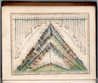
(View) A View of the Comparative Lengths of the Principal Rivers, and the Heights of the Principal Mountains of the World.
List No
0247.004
Author
Adams, Daniel
Full Title
(Covers to) Atlas to Adams' geography. Containing the following maps ... Boston: Published by Lincoln & Edmands, No. 59 Washington Street. Cushing & Sons, and Joseph Jewett, Baltimore. Hubbard & Edmands, Cincinnati. Sold by them and by the principal booksellers in the United States. 1832.
List No
0006A
Note
11 maps by H. Morse, who, according to the Dictionary of American Painters, Sculptures, and Engravers, is Hazen Morse. He worked for Annin and Smith as an engraver. He did many of the school atlases of the period -- Adams, Worcester, Cummings, and Blake. In outline color. With brown covers. Cover title.
Full Title
The World. G. Boynton Sc. Published by Lincoln & Edmands. (1832)
List No
0006.001
Note
Engraved double hemisphere map. Outline hand col. Insets: Comparative view of the principal lakes in the eastern continent -- Comparative view of the principal lakes of the western continent -- Zones -- Circles -- Parallels -- Meridians.
Full Title
North America. H. Morse Sc. Published by Lincoln & Edmands, Boston. (1832)
List No
0006.002
Note
Engraved map. Outline hand col. Relief shown pictorially.
Full Title
United States. H. Morse Sc. Published by Lincoln & Edmands, Boston. (1832)
List No
0006.003
Note
Engraved map. Outline hand col. Relief shown pictorially. Includes inset. Prime meridians: Washington and Greenwich.
Full Title
New England States. Middle States. H. Morse Sc. Published by Lincoln & Edmands, Boston. (1832)
List No
0006.004
Note
Two engraved maps on 1 sheet. Outline hand col. Relief shown pictorially. Prime meridians: Greenwich and Washington.
Full Title
Western States. H. Morse Sc. Published by Lincoln & Edmands, Boston. (1832)
List No
0006.005
Note
Engraved map. Outline hand col. Relief shown pictorially. Covers Missouri, Illinois, Indiana, Ohio, Kentucky and Tennessee.
Full Title
South America. Published by Lincoln & Edmands, Boston. (1832)
List No
0006.006
Note
Engraved map. Outline hand col. Relief shown by hachures.
Full Title
Europe. H. Morse Sc. Published by Lincoln & Edmands, Boston. (1832)
List No
0006.007
Note
Engraved map. Outline hand col. Relief shown pictorially.
Full Title
British Isles. Asia. H. Morse Sc. Published by Lincoln & Edmands, Boston. (1832)
List No
0006.008
Note
Two engraved maps on 1 sheet. Outline hand col. Relief shown pictorially. Includes inset of Shetland Isles.
Full Title
Africa. H. Morse Sc. Published by Lincoln & Edmands, Boston. (1832)
List No
0006.009
Note
Engraved map. Outline hand col. Relief shown pictorially. Prime meridians: Greenwich and Washington. Engraver name is very faint (erased from plate?)
Author
Arrowsmith, John
Full Title
Orbis Veteribus Notus, auctore J. Arrowsmith. London, pubd. 15 Feby. 1832, by J. Arrowsmith, 35 Essex Street, Strand.
List No
0036.001
Note
Engraved map. Hand colored boundaries. Relief shown by hachures. (Mercator projection)
Author
Arrowsmith, John
Full Title
Europe, by J. Arrowsmith. London, pubd. 15 Feby. 1832 by J. Arrowsmith, 35 Essex Street, Strand.
List No
0036.003
Note
Engraved map. Hand colored boundaries. Relief shown by hachures.
Author
Arrowsmith, John
Full Title
England, by J. Arrowsmith. London, pubd. 15 Feby. 1832 by J. Arrowsmith, 35 Essex Street, Strand.
List No
0036.004
Note
Engraved map. County boundaries hand colored. Relief shown by hachures.
Author
Arrowsmith, John
Full Title
Ireland, by J. Arrowsmith. London, pubd. 15 Feby. 1832 by J. Arrowsmith, 35 Essex Street, Strand.
List No
0036.007
Note
Engraved map. County boundaries hand colored. Relief shown by hachures. Includes inset map showing the provinces.
Author
Arrowsmith, John
Full Title
Sweden & Norway, by J. Arrowsmith. London, pubd. 15 Feby. 1832 by J. Arrowsmith, 35 Essex Street, Strand.
List No
0036.008
Note
Engraved map. Hand colored boundaries. Relief shown by hachures. Includes inset.
Author
Arrowsmith, John
Full Title
Denmark, by J. Arrowsmith. (with Iceland). London, pubd. 15 Feby. 1832 by J. Arrowsmith, 35 Essex Street, Strand.
List No
0036.009
Note
Engraved map. Hand colored boundaries. Relief shown by hachures. Includes Holstein and Lauenburg.
Author
Arrowsmith, John
Full Title
Holland & Belgium, by J. Arrowsmith. London, pubd. 15 Feby. 1832 by J. Arrowsmith, 35 Essex Street, Strand.
List No
0036.010
Note
Engraved map. Hand colored boundaries. Relief shown by hachures. Covers also Luxembourg.
Author
Arrowsmith, John
Full Title
Western Germany, by J. Arrowsmith. London, pubd. 15 Feby. 1832 by J. Arrowsmith, 35 Essex Street, Strand.
List No
0036.012
Note
Engraved map. Hand colored boundaries. Relief shown by hachures.
Author
Arrowsmith, John
Full Title
Russia & Poland, by J. Arrowsmith. London, pubd. 15 Feby. 1832 by J. Arrowsmith, 35 Essex Street, Strand.
List No
0036.014
Note
Engraved map. Hand colored boundaries. Relief shown by hachures.
Author
Arrowsmith, John
Full Title
Austrian Empire, by J. Arrowsmith. London, pubd. 15 Feby. 1832 by J. Arrowsmith, 35 Essex Street, Strand.
List No
0036.015
Note
Engraved map. Hand colored boundaries. Relief shown by hachures.
Author
Arrowsmith, John
Full Title
Switzerland &c. and the passes of the Alps, by J. Arrowsmith. London, pubd. 15 Feby. 1832 by J. Arrowsmith, 35 Essex Street, Strand.
List No
0036.016
Note
Engraved map. Hand colored boundaries. Relief shown by hachures.
Author
Arrowsmith, John
Full Title
South Italy, by J. Arrowsmith. (with) The Maltese Islands. London, pubd. 15 Feby. 1832 by J. Arrowsmith, 35 Essex Street, Strand.
List No
0036.018
Note
Engraved map. Hand colored boundaries. Relief shown by hachures.
Author
Arrowsmith, John
Full Title
Turkey in Europe, by J. Arrowsmith. London, pubd. 15 Feby. 1832 by J. Arrowsmith, 35 Essex Street, Strand.
List No
0036.019
Note
Engraved map. Hand colored boundaries. Relief shown by hachures.
Author
Arrowsmith, John
Full Title
Greece and the Ionian Islands, by J. Arrowsmith. London, pubd. 15 Feby. 1832 by J. Arrowsmith, 35 Essex Street, Strand.
List No
0036.020
Note
Engraved map. Hand colored boundaries. Relief shown by hachures.
Author
Arrowsmith, John
Full Title
Spain & Portugal, by J. Arrowsmith. London, pubd. 15 Feby. 1832 by J. Arrowsmith, 35 Essex Street, Strand.
List No
0036.021
Note
Engraved map. Hand colored boundaries. Relief shown by hachures. Includes inset of Minorca.
Author
Arrowsmith, John
Full Title
Nubia and Abyssinia, by J. Arrowsmith. London, pubd. 15 Feby. 1832 by J. Arrowsmith, 35 Essex Street, Strand.
List No
0036.025
Note
Engraved map. Hand colored boundaries. Relief shown by hachures.
Author
Arrowsmith, John
Full Title
Egypt, by J. Arrowsmith. London, pubd. 15 Feby. 1832 by J. Arrowsmith, 35 Essex Street, Strand.
List No
0036.026
Note
Engraved map. Hand colored boundaries. Relief shown by hachures.
Author
Arrowsmith, John
Full Title
Asia, by J. Arrowsmith. London, pubd. 15 Feby. 1832 by J. Arrowsmith, 35 Essex Street, Strand.
List No
0036.027
Note
Engraved map. Hand colored boundaries. Relief shown by hachures.
Author
Arrowsmith, John
Full Title
Turkey in Asia, by J. Arrowsmith. London, pubd. 15 Feby. 1832 by J. Arrowsmith, 35 Essex Street, Strand.
List No
0036.028
Note
Engraved map. Hand colored boundaries. Relief shown by hachures.
Author
Arrowsmith, John
Full Title
India, by J. Arrowsmith. London, pubd. 15 Feby. 1832 by J. Arrowsmith, 35 Essex Street, Strand.
List No
0036.030
Note
Engraved map. Hand colored boundaries. Relief shown by hachures.
Author
Arrowsmith, John
Full Title
Burmah, Siam, and Cochin China, by J. Arrowsmith. London, pubd. 15 Feby. 1832 by J. Arrowsmith, 35 Essex Street, Strand.
List No
0036.031
Note
Engraved map. Hand colored boundaries. Relief shown by hachures.
Author
Arrowsmith, John
Full Title
China, by J. Arrowsmith. London, pubd. 15 Feby. 1832 by J. Arrowsmith, 35 Essex Street, Strand.
List No
0036.032
Note
Engraved map. Hand colored boundaries. Relief shown by hachures.
Author
Arrowsmith, John
Full Title
Northern Asia, from the Himalaya Mountains to the Arctic Ocean, by J. Arrowsmith. (London, pubd. 1832? by J. Arrowsmith, 35 Essex) Street, Strand.
List No
0036.033
Note
Engraved map. Hand colored boundaries. Relief shown by hachures. Left section of the map has a panel tipped in showing Tibet (obscures most of imprint)
Author
Arrowsmith, John
Full Title
Asiatic Archipelago, by J. Arrowsmith. London, pubd. 15 Feby. 1832 by J. Arrowsmith, 35 Essex Street, Strand.
List No
0036.034
Note
Engraved map. Hand colored boundaries. Relief shown by hachures. Note discusses the possession of the Island of Singapore by the British. Second note below the island of Lombock states, "Volcano of Tumbora in Sumbawa Island. A tremendous eruption of this Vol. exceeding any thing (sic) on record of the same nature, took place, April 1815...(240 miles West of the Vol.) ashes fell to the depth of 8 inches."
Author
Arrowsmith, John
Full Title
Pacific Ocean, by J. Arrowsmith. London, pubd. 15 Feby. 1832 by J. Arrowsmith, 35 Essex Street, Strand.
List No
0036.038
Note
Engraved map. Hand colored boundaries. Relief shown by hachures. Mercator projection.
Author
Arrowsmith, John
Full Title
Mexico, by J. Arrowsmith. (with) Mexico, shewing the connection with the ports of Acapulco, Vera Cruz & Tampico. London, pubd. 15 Feby. 1832 by J. Arrowsmith, 35 Essex Street, Strand.
List No
0036.044
Note
Engraved map. Hand colored boundaries. Relief shown by hachures. Shows states and provinces, roads, Indian tribes, etc.
Author
Arrowsmith, John
Full Title
West Indies, by J. Arrowsmith. London, pubd. 15 Feby. 1832 by J. Arrowsmith, 35 Essex Street, Strand.
List No
0036.045
Note
Engraved map. Hand colored boundaries. Relief shown by hachures. Covers also Central America. Includes inset.
Author
Arrowsmith, John
Full Title
Brazil, by J. Arrowsmith. London, pubd. Feby. 15, 1832 by J. Arrowsmith, 35 Essex Street, Strand.
List No
0036.049
Note
Engraved map. Hand colored boundaries. Relief shown by hachures. Shows political divisions, roads, Indian tribes, etc. Includes the Guianas, Paraguay and Uruguay.
Author
Burr, David H., 1803-1875
Full Title
Map of the State of New-York and the surrounding country by David H. Burr. Compiled from his large map of the State, 1832. (with) Profile of the Grand Erie Canal. (with) Profile of the Champlain Canal. (with) Profile of the Seneca Canal. Entered according to Act of Congress Jany. 5th., 1829 by David H. Burr of the State of New York. Engd. by Rawdon, Clark & Co., Albany & Rawdon, Wright & Co., New York.
List No
0103.001
Note
Hand col. engraved map. Relief shown by hachures. Covers Connecticut, Rhode Island, Vermont and parts of New Hampshire, Massachusetts, New Jersey and Pennsylvania. Prime meridian: Washington, D.C.
Author
Burr, David H., 1803-1875
Full Title
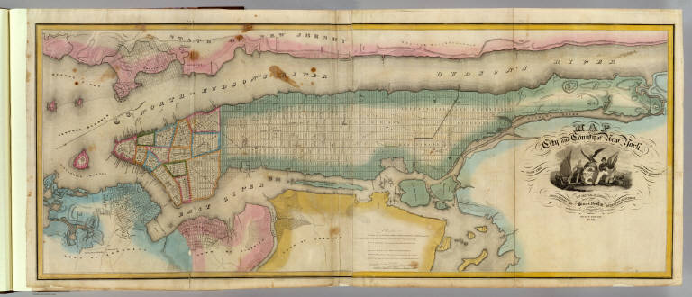
Map of the City and County of New York with the adjacent country, by David H. Burr, published by Simeon DeWitt, Surveyor General, pursuant to an Act of the Legislature. Second edition 1832.
List No
0103.002
Note
Hand col. engraved map on 2 sheets. Relief shown by hachures. Covers also Jersey City and Horsimus and other communities in N.J. Ornamental cartouche. Includes "Remarks" on streets and distances. David Rumsey Collection copy mounted as 1 sheet.
Author
[Dower, John, Higgins, W.M.]
Full Title
(Covers to) A General Descriptive Atlas Of The Earth, Containing Separate Maps Of The Various Countries And States, From Original Drawings. With A Short Account Of Each Country, Descriptive Of Its Geographical Features, Chief Towns And Cities, Population, And General Statistics. By W.M. Higgins ... London: Published By W.S. Orr & Co., Paternoster Row; And W. And R. Chambers, Waterloo Place, Edinburgh. (on verso) London: Bradbury And Evans, Printers, Whitefriars.
List No
0247.001
Note
This atlas is bound in half leather dark green cloth covered boards with "Atlas Of The Earth" stamped in gold on the spine.
Author
[Dower, John, Higgins, W.M.]
Full Title
(Liner of Front Cover) (Handwritten Provenance) Wm. Sawry Gilpin, Digby, Nova Scotia, 1883.
List No
0247.002
Note
According to ArchivesCanada.com: "BIOGRAPHICAL SKETCH: William Sawry Gilpin was the son of Dr. John Bernard and Charlotte Gilpin, born in 1850 at Digby, Nova Scotia. William was raised by his maternal grandfather, Benjamin Smith at St. John, New Brunswick following the death of his mother in 1851. He later returned to Digby, built a home and married Elizabeth Butterworth Waters in 1850. Elizabeth died the following year and in 1853 William married Elizabeth's sister Mary. The couple had five children: Charlotte, Thomas Bernard, William Sawry, Mary Waters and Charles Henry. Gilpin, a reknown sportsman and hunter, died while moose hunting in 1885."
Author
[Dower, John, Higgins, W.M.]
Full Title
(Half Title Page) A General Descriptive Atlas Of The Earth.
List No
0247.003
Author
[Dower, John, Higgins, W.M.]
Full Title
(Title Page) A General Descriptive Atlas Of The Earth, Containing Separate Maps Of The Various Countries And States, From Original Drawings. With A Short Account Of Each Country, Descriptive Of Its Geographical Features, Chief Towns And Cities, Population, And General Statistics. By W.M. Higgins ... London: Published By W.S. Orr & Co., Paternoster Row; And W. And R. Chambers, Waterloo Place, Edinburgh. (on verso) London: Bradbury And Evans, Printers, Whitefriars.
List No
0247.005
Author
[Dower, John, Higgins, W.M.]
Full Title
(Table of Contents) Contents.
List No
0247.006
Author
[Dower, John, Higgins, W.M.]
Full Title
The World, on Mercator Projection.
List No
0247.007
Author
[Dower, John, Higgins, W.M.]
Full Title
(Text Page) Mercator's Projection.
List No
0247.008
Author
[Dower, John, Higgins, W.M.]
Full Title
(Text Page) Mercator's Projection.
List No
0247.009
Author
[Dower, John, Higgins, W.M.]
Full Title
Eastern Hemisphere.
List No
0247.010
Author
[Dower, John, Higgins, W.M.]
Full Title
Western Hemisphere.
List No
0247.011
|