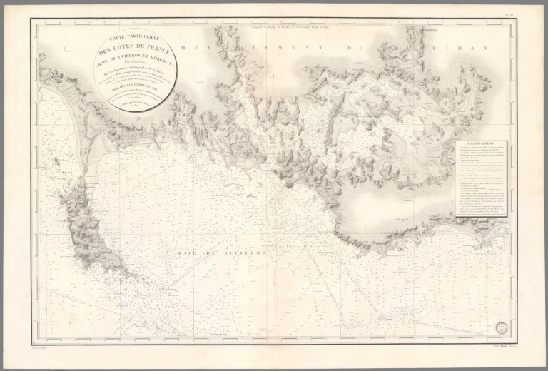
Depot General de la Marine; Beautemps-Be... Carte Particuliere Des Cotes De France (... 1827 15934.138 Related Author
[Depot General de la Marine, Beautemps-Beaupré, Charles François, 1766-1854]
Full Title
Carte Particuliere Des Cotes De France (Baie De Quiberon Et Morbihan)
List No
15934.138
Note
Hydrographie Française 4
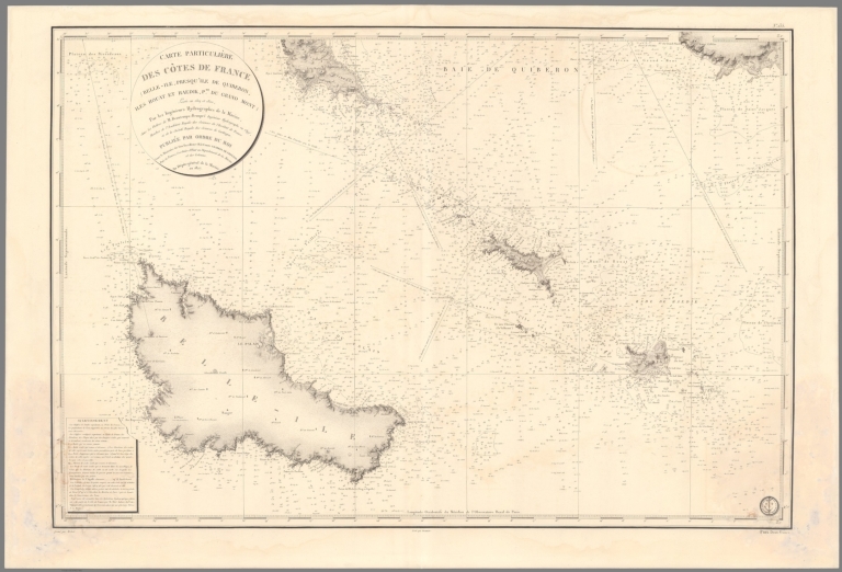
Depot General de la Marine; Beautemps-Be... Carte Particuliere Des Cotes De France (... 1827 15934.140 Related Author
[Depot General de la Marine, Beautemps-Beaupré, Charles François, 1766-1854]
Full Title
Carte Particuliere Des Cotes De France (Belle-Ile, Presqu'ille De Quiberon, Iles Houat Et Haedik, Pte Du Gtand Mont
List No
15934.140
Note
Hydrographie Française 4
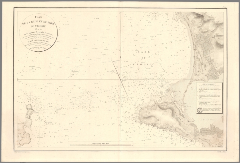
Depot General de la Marine; Beautemps-Be... Plan De La Rade Et Du Port Du Croisic 1827 15934.144 Related Author
[Depot General de la Marine, Beautemps-Beaupré, Charles François, 1766-1854]
Full Title
Plan De La Rade Et Du Port Du Croisic
List No
15934.144
Note
Hydrographie Française 4
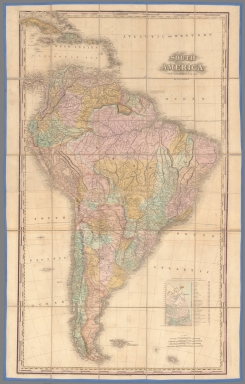
Author
Tanner, Henry S.
Full Title
South America With Improvements To 1827 By H. S. Tanner. Entered ... 8th Day of June, 1818 by Tanner, Vallance, Kearny & Co. of the State of Pennsylvania. Engraved & Published by H.S. Tanner Philadelphia.
List No
5400.000
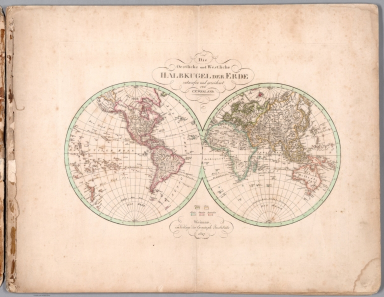
Weiland, C. F. (Carl Ferdinand), 1782-18... Die Oestliche und Westliche Halbkugel de... 1827 14365.004 Related Author
Weiland, C. F. (Carl Ferdinand), 1782-1847
Full Title
Die Oestliche und Westliche Halbkugel der Erde entworfen und gezeichnet von C. F. Weiland. Weimar, im Verlag des Geograph. Instituts, 1827. C. Metzeroth sc. a Weimar.
List No
14365.004
Note
Map of the world presented as circular Western and Eastern Hemispheres, as of 1827. Shows continental boundaries, countries, major cities, topography, deserts, bodies of water, drainage, coastlines and islands. Relief shown with hachures. Includes latitudinal and longitudinal lines, as well as a legend. Hand-colored engraving. Map is 23 x 43 cm, on sheet 45 x 57 cm. (Plate number taken from table of contents.)
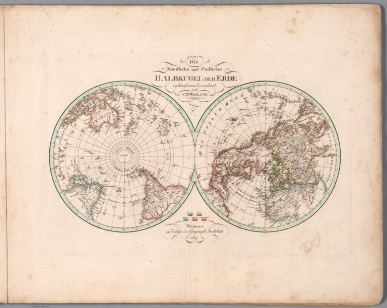
Weiland, C. F. (Carl Ferdinand), 1782-18... Die Nördliche und Südliche Halbkugel der... 1827 14365.005 Related Author
Weiland, C. F. (Carl Ferdinand), 1782-1847
Full Title
Die Nördliche und Südliche Halbkugel der Erde entworfen und gezeichnet von C. F. Weiland. Weimar, im Verlag des Geograph. Instituts, 1827. C. Metzeroth sc. a Weimar.
List No
14365.005
Note
Map of the world presented as circular Northern and Southern Hemispheres, as of 1827. Shows continental boundaries, countries, major cities, topography, deserts, bodies of water, drainage, coastlines and islands. Relief shown with hachures. Includes latitudinal and longitudinal lines, as well as a legend. Hand-colored engraving. Map is 23 x 44 cm, on sheet 45 x 57 cm. (Plate number taken from table of contents.)
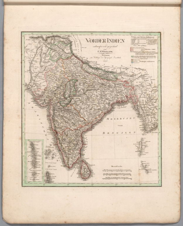
Author
Weiland, C. F. (Carl Ferdinand), 1782-1847
Full Title
Vorder Indien entworfen und gezeichnet von C. F. Weiland. Weimar, im Verlag des Geograph. Instituts, 1827.
List No
14365.047
Note
Map of India, as of 1827. Shows political boundaries, cities, railways, canals, population, topography, bodies of water, drainage, coastlines and islands. Relief shown with hachures. Includes latitudinal and longitudinal lines, as well as a legend and three bar scales. With inset map: Acht Grad Canal. Hand-colored engraving. Map is 37 x 34 cm, on sheet 57 x 45 cm. (Plate number taken from table of contents.)
Author
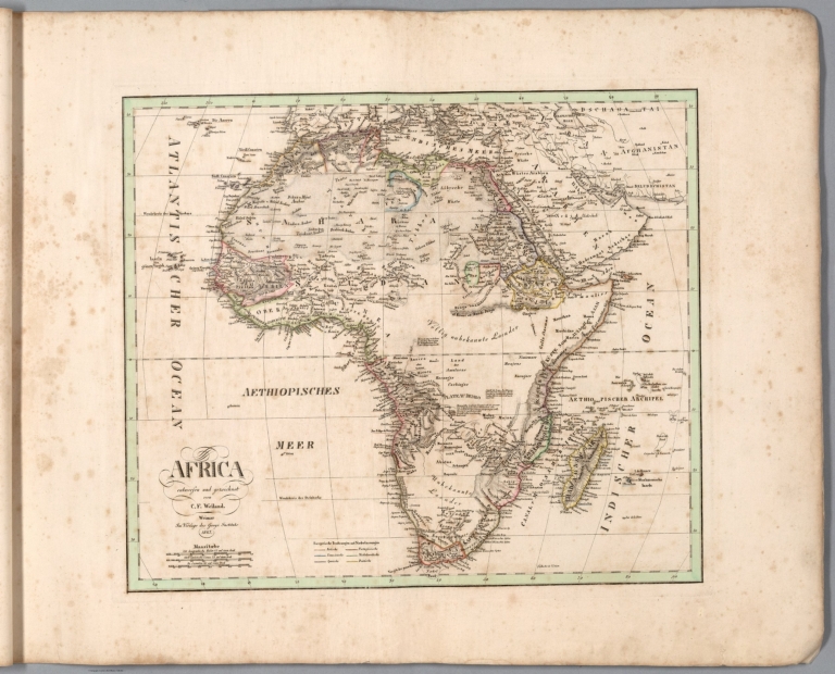
Weiland, C. F. (Carl Ferdinand), 1782-1847
Full Title
Africa entworfen und gezeichnet von C. F. Weiland. Weimar, im Verlag des Geogr. Instituts, 1827.
List No
14365.050
Note
Map of Africa, as of 1827. Shows political boundaries (including European colonies), cities, topography, deserts, bodies of water, drainage, coastlines, shoals and islands. Relief shown with hachures. Includes latitudinal and longitudinal lines, as well as a legend, three bar scales and descriptive text throughout. Hand-colored engraving. Map is 32 x 38 cm, on sheet 45 x 57 cm. (Plate number taken from table of contents.)
Author
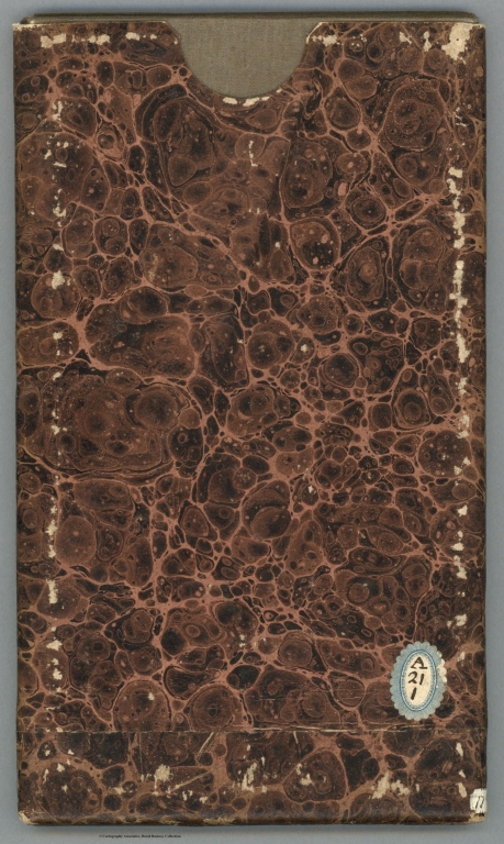
Desilver, Roberto
Full Title
(Covers to) [Un libro de mapas.]
List No
14368.001
Note
Covers to Un libro de mapas. Bound in board, covered in marbled papers, with reinforced corners and spine in green.
Author
Desilver, Roberto
Full Title
(Title Page to) Un libro de mapas. Filadelfia : Roberto Desilver 110 Walnut Street, 1827.
List No
14368.002
Note
Title page to Un libro de mapas. Includes list of ten maps within volume.
Author
Desilver, Roberto
Full Title
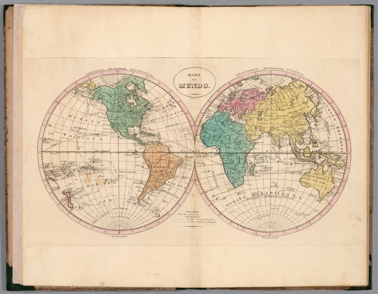
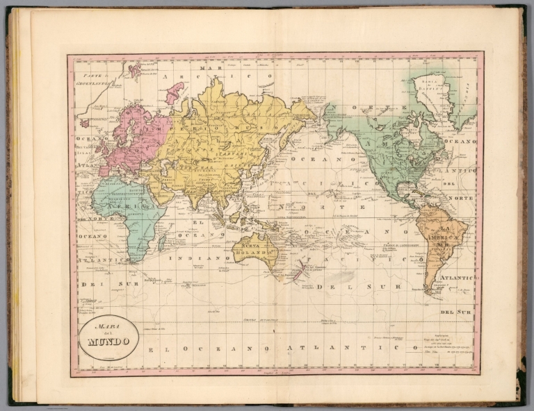
Mapa del mundo. J. Bower sc.
List No
14368.003
Note
World map, presented in circular Western and Eastern Hemispheres. Shows political boundaries, cities, topography, bodies of water, drainage, coastlines and islands. Features routes of explorers, with dates of voyages. Relief shown pictorially. Includes latitudinal and longitudinal lines, as well as a legend. With title cartouche. Hand-colored engraving. Map is 25 x 49 cm, on double sheet 45 x 55 cm.
Author
Desilver, Roberto
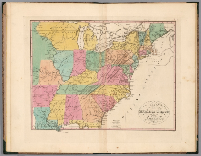
Full Title
Mapa de los Estados Unidos de America. Gridley, sc.
List No
14368.004
Note
Map of the United States. Shows political boundaries, cities, railways, canals, topography, bodies of water, drainage, coastlines and islands. Relief shown with hachures. Includes latitudinal and longitudinal lines, as well as a legend and bar scale. With title cartouche. Hand-colored engraving. Map is 33 x 42 cm, on double sheet 45 x 55 cm.
Author
Desilver, Roberto
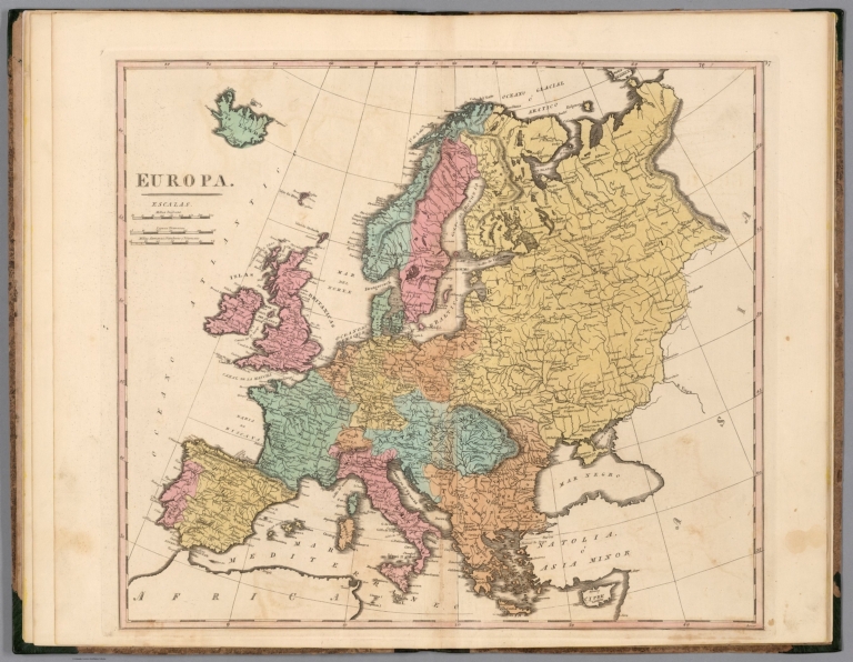
Full Title
Europa. Bower.
List No
14368.005
Note
Map of Europe. Shows political boundaries, cities, topography, bodies of water, drainage, coastlines and islands. Relief shown with hachures. Includes latitudinal and longitudinal lines, as well as three bar scales. Hand-colored engraving. Map is 39 x 44 cm, on double sheet 45 x 55 cm.
Author
Desilver, Roberto
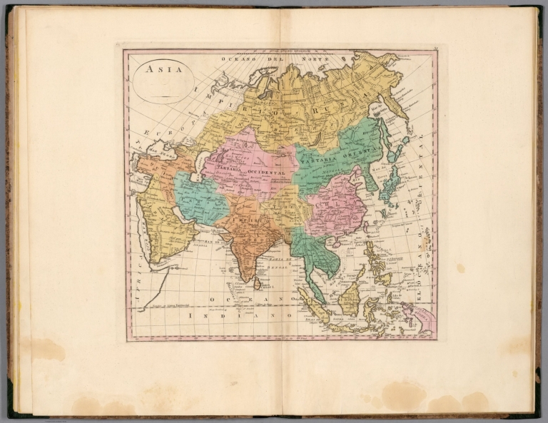
Full Title
Asia.
List No
14368.006
Note
Map of Asia. Shows political boundaries, cities, topography, bodies of water, drainage, coastlines and islands. Relief shown pictorially. Includes latitudinal and longitudinal lines. With title cartouche. Hand-colored engraving. Map is 32 x 34 cm, on double sheet 45 x 55 cm.
Author
Desilver, Roberto
Full Title
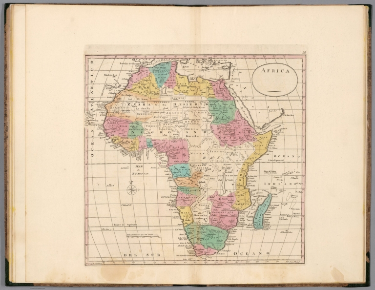
Africa.
List No
14368.007
Note
Map of Africa. Shows political boundaries, cities, topography, bodies of water, drainage, coastlines and islands. Relief shown pictorially. Includes latitudinal and longitudinal lines, as well as a bar scale and compass rose with north oriented toward top of sheet. With title cartouche. Hand-colored engraving. Map is 33 x 35 cm, on double sheet 45 x 55 cm.
Author
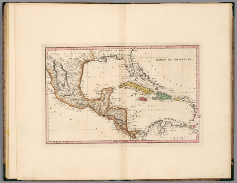
Desilver, Roberto
Full Title
Indias Occidentales.
List No
14368.008
Note
Map of the West Indies. Shows political boundaries, cities, topography, bodies of water, drainage, coastlines and islands. Relief shown with hachures. Includes latitudinal and longitudinal lines. Hand-colored engraving. Map is 24 x 40 cm, on double sheet 45 x 55 cm.
Author
Desilver, Roberto
Full Title
Escosia.
List No
14368.009
Note
Map of Scotland. Shows political boundaries, cities, topography, bodies of water, drainage, coastlines and islands. Relief shown with hachures. Includes latitudinal and longitudinal lines, as well as a bar scale and compass rose with north oriented toward top of sheet. With inset map: Islas de Setlanda. Hand-colored engraving. Map is 37 x 31 cm, on double sheet 55 x 45 cm.
Author
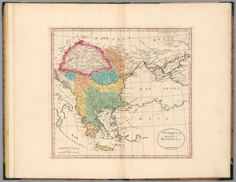
Desilver, Roberto
Full Title
Turquia en Europa y Hungria.
List No
14368.010
Note
Map of Turkey (in Europe) and Hungary. Shows political boundaries, cities, topography, bodies of water, drainage, coastlines and islands. Relief shown with hachures. Includes latitudinal and longitudinal lines, as well as two bar scales. Hand-colored engraving. Map is 32 x 35 cm, on double sheet 45 x 55 cm.
Author
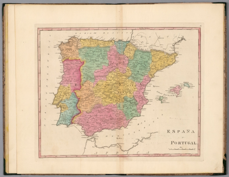
Desilver, Roberto
Full Title
España y Portugal.
List No
14368.011
Note
Map of Spain and Portugal. Shows political boundaries, cities, topography, bodies of water, drainage, coastlines and islands. Relief shown with hachures. Includes latitudinal and longitudinal lines, as well as a bar scale. Hand-colored engraving. Map is 33 x 41 cm, on double sheet 45 x 55 cm.
Author
Desilver, Roberto
Full Title
Mapa del mundo. J. Yeager sc.
List No
14368.012
Note
World map, centered around the Pacific Ocean. Shows political boundaries, cities, topography, bodies of water, drainage, coastlines and islands. Features routes of explorers, with dates of voyages. Relief shown pictorially. Includes latitudinal and longitudinal lines, as well as a legend. With title cartouche. Hand-colored engraving. Map is 35 x 45 cm, on double sheet 45 x 55 cm.
Author
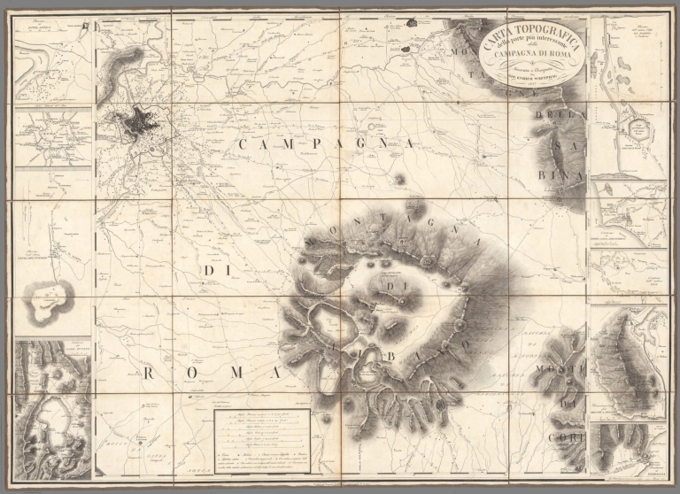
Westphal, Giovanni Enrico
Full Title
(Covers to) Carta Topografica della parte piu interessante della Campagna di Roma Misurata e Disegnata du Gio. Enrico Westphal.
List No
10890.001
Note
Vendesi nel Negozio Scudellari - For sale in the Scudellari Shop. Inset maps: Ruins of Ostia Antica. Rome. Ruins of the Ancient City of Tusculum. Contours of Lake Fucino. Ruins of the ancient city of Porto and Contours. Outlines of Porto, Ostia, and Tor Paterno. Outlines of ancient Veji. Circeo Promontory or Monte S. Felice. Outlines of Terracina.
Author
Westphal, Giovanni Enrico
Full Title
Carta Topografica della parte piu interessante della Campagna di Roma Misurata e Disegnata du Gio. Enrico Westphal.
List No
10890.002
Note
Vendesi nel Negozio Scudellari - For sale in the Scudellari Shop. Inset maps: Ruins of Ostia Antica. Rome. Ruins of the Ancient City of Tusculum. Contours of Lake Fucino. Ruins of the ancient city of Porto and Contours. Outlines of Porto, Ostia, and Tor Paterno. Outlines of ancient Veji. Circeo Promontory or Monte S. Felice. Outlines of Terracina.
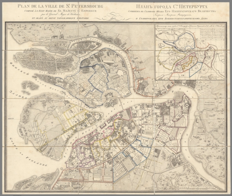
Witzthum; Voenno-Topografitcheskoe Depo ... Plan de la Ville De St. Petersbourg 1827 10754.000 Related Author
[Witzthum, Voenno-Topografitcheskoe Depo (Saint Petersbourg)]
Full Title
Plan de la ville de St-Pétersbourg / composé à l'Etat-Major de Sa Majesté l'Empereur par le général-major de Vitzthum et ; gravé au depot topographique militaire
List No
10754.000
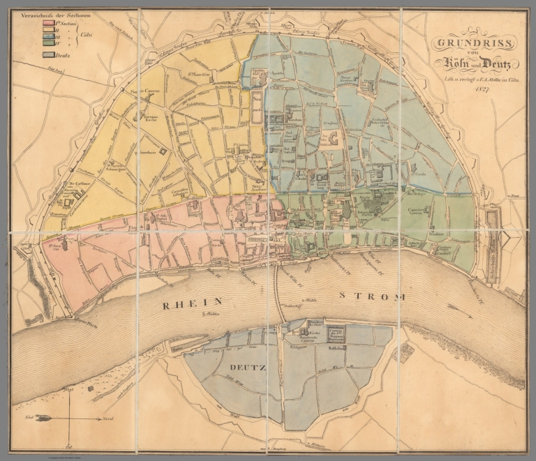
Author
Mottu, F.A.
Full Title
Grundriss von Köln und Deutz
List No
10764.000
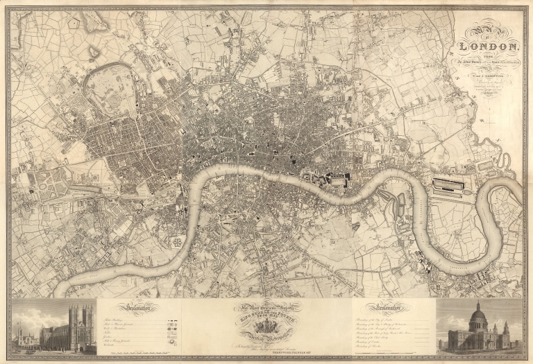
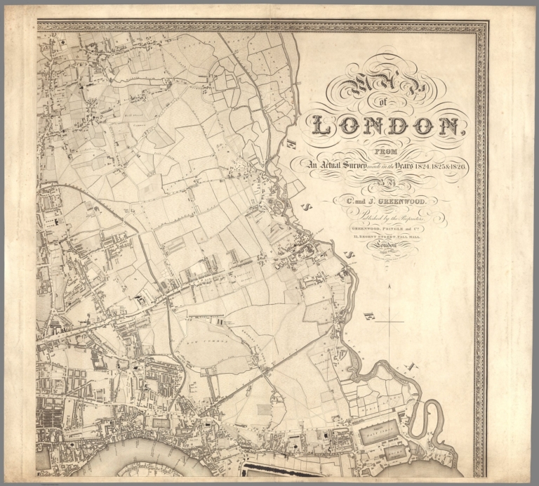
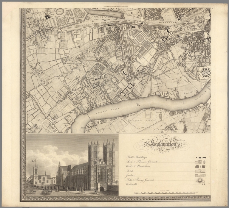
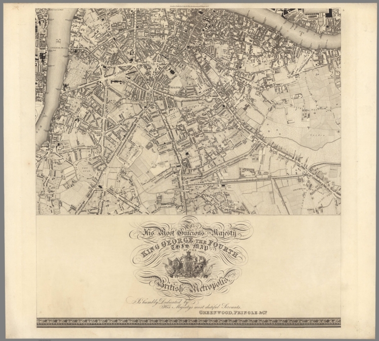
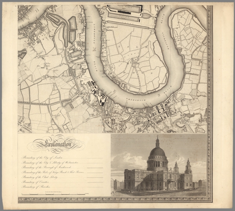
Greenwood, Christopher; Greenwood, John Composite: Sheets 1-6. Map of London... ... 1827 10241.001 Related Author
[Greenwood, Christopher, Greenwood, John]
Full Title
(Composite map of) (Sheets 1-6) Map of London, From an actual Survey made in the Years 1824.1825 & 1826. By C. and J. Greenwood. Published by the Proprietors... August 21 1827.
List No
10241.001
Note
Scale 8 inches to the mile.
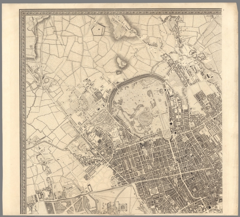
Greenwood, Christopher; Greenwood, John Sheet 1. Map of London... August 21 1827... 1827 10241.002 Related Author
[Greenwood, Christopher, Greenwood, John]
Full Title
(Sheet 1) Map of London, From an actual Survey made in the Years 1824.1825 & 1826. By C. and J. Greenwood. Published by the Proprietors... August 21 1827.
List No
10241.002
Note
Scale 8 inches to the mile.
Greenwood, Christopher; Greenwood, John Sheet 2. Map of London... August 21 1827... 1827 10241.003 Related Author
[Greenwood, Christopher, Greenwood, John]
Full Title
(Sheet 2) Map of London, From an actual Survey made in the Years 1824.1825 & 1826. By C. and J. Greenwood. Published by the Proprietors... August 21 1827.
List No
10241.003
Note
Scale 8 inches to the mile.
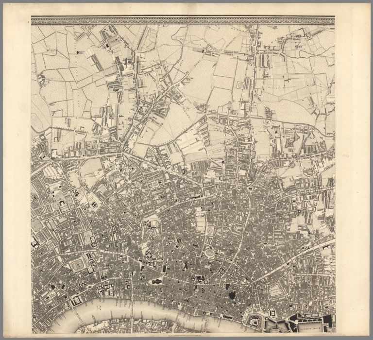
Greenwood, Christopher; Greenwood, John Sheet 3. Map of London... August 21 1827... 1827 10241.004 Related Author
[Greenwood, Christopher, Greenwood, John]
Full Title
(Sheet 3) Map of London, From an actual Survey made in the Years 1824.1825 & 1826. By C. and J. Greenwood. Published by the Proprietors... August 21 1827.
List No
10241.004
Note
Scale 8 inches to the mile.
Greenwood, Christopher; Greenwood, John Sheet 4. Map of London... August 21 1827... 1827 10241.005 Related Author
[Greenwood, Christopher, Greenwood, John]
Full Title
(Sheet 4) Map of London, From an actual Survey made in the Years 1824.1825 & 1826. By C. and J. Greenwood. Published by the Proprietors... August 21 1827.
List No
10241.005
Note
Scale 8 inches to the mile.
Greenwood, Christopher; Greenwood, John Sheet 5. Map of London... August 21 1827... 1827 10241.006 Related Author
[Greenwood, Christopher, Greenwood, John]
Full Title
(Sheet 5) Map of London, From an actual Survey made in the Years 1824.1825 & 1826. By C. and J. Greenwood. Published by the Proprietors... August 21 1827.
List No
10241.006
Note
Scale 8 inches to the mile.
Greenwood, Christopher; Greenwood, John Sheet 6. Map of London... August 21 1827... 1827 10241.007 Related Author
[Greenwood, Christopher, Greenwood, John]
Full Title
(Sheet 6) Map of London, From an actual Survey made in the Years 1824.1825 & 1826. By C. and J. Greenwood. Published by the Proprietors... August 21 1827.
List No
10241.007
Note
Scale 8 inches to the mile.
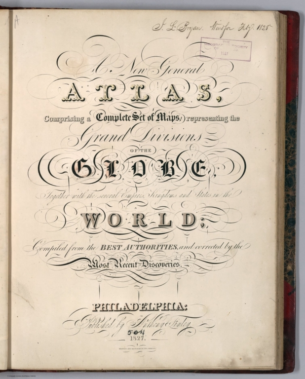
Author
Finley, Anthony
Full Title
(Title Page to) A New General Atlas Comprising a Complete Set of Maps, representing the Grand Divisions Of The Globe, Together with the several Empires, Kingdoms, and States in the World; Compiled from the Best Authorities, and corrected by the Most Recent Discoveries. Philadelphia: Published by Anthony Finley. 1827. (title page only) Written And Engraved By Jos. Perkins.
List No
0282.002
Note
This 1827 of the New general atlas was issued with substantial county changes in the developing states since the second 1824 issue. The atlas was first issued in 1824, with editions published annually to 1834. Each succeeding year new maps were added and others updated. This atlas bound in half leather marbled paper covered boards covers with a green label printed with "A New General Atlas, Containing Sixty Maps. Philadelphia: Published By Anthony Finley." and "Finley General Atlas" stamped in gold on the spine. Engraved title page "written and engraved by Jos. Perkins", index and statistical table; 58 hand colored maps engraved by Young & Delleker and 2 engraved hand colored tables.
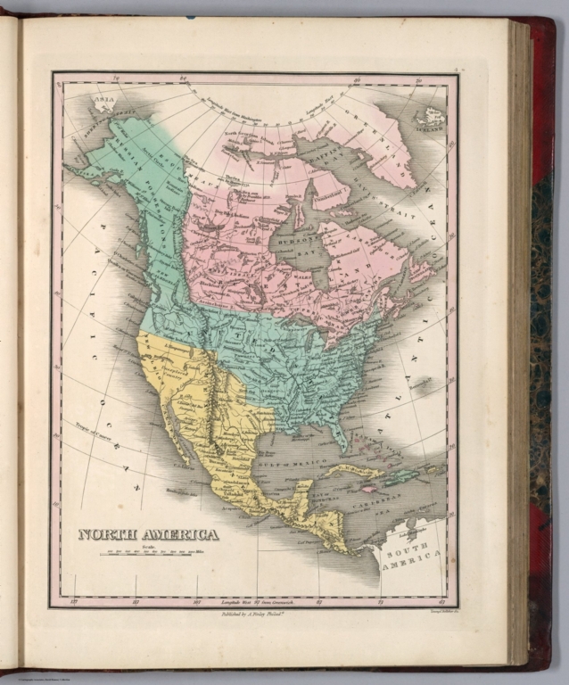
Author
Finley, Anthony
Full Title
North America. Young & Delleker Sc. Published by A. Finley, Philada. (to accompany) A New General Atlas Comprising a Complete Set of Maps, representing the Grand Divisions Of The Globe ... Philadelphia: Published by Anthony Finley. 1827.
List No
0282.008
Note
Full color map by country on sheet 35x27. Relief shown pictorially. Prime meridian is Greenwich. Shows major cities, capitals, rivers and ports.
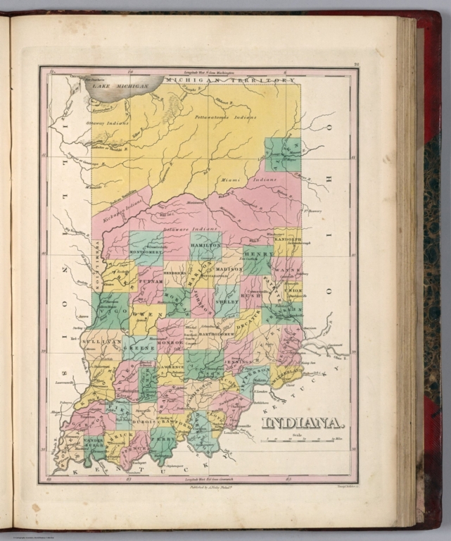
Author
Finley, Anthony
Full Title
Indiana. Young & Delleker Sc. Published by A. Finley, Philada. (to accompany) A New General Atlas Comprising a Complete Set of Maps, representing the Grand Divisions Of The Globe ... Philadelphia: Published by Anthony Finley. 1827.
List No
0282.030
Note
Full color map on sheet 35x27. Relief shown pictorially. Prime meridians are Washington and Greenwich. Shows counties, major cities, roads and rivers.
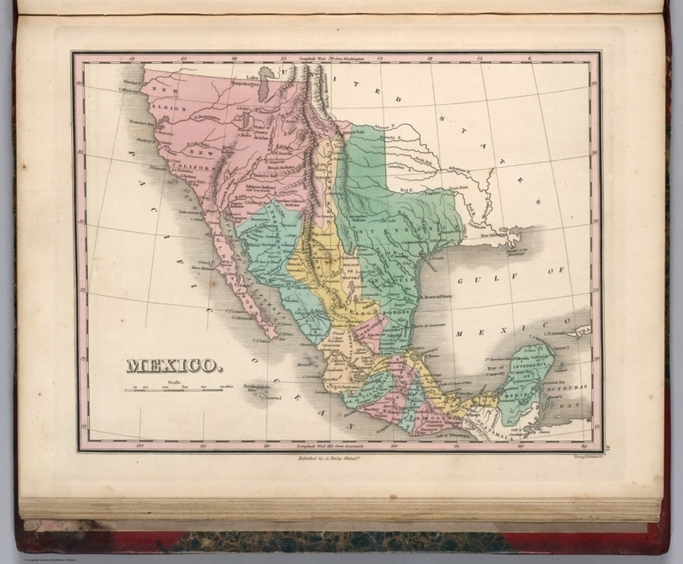
Author
Finley, Anthony
Full Title
Mexico. Young & Delleker Sc. Published by A. Finley, Philada. (to accompany) A New General Atlas Comprising a Complete Set of Maps, representing the Grand Divisions Of The Globe ... Philadelphia: Published by Anthony Finley. 1827.
List No
0282.035
Note
Full color map on sheet 35x27. Relief shown pictorially. Prime meridians are Washington and Greenwich. Covers California, Texas and New Mexico. Shows political boundaries, administrative divisions, major cities, Indian settlements and rivers.
Author
Flocchi, Pietro
Full Title
Grand' Albero Genealogico Storico Dei Popoli Italiani.
List No
12315.000
Author
Brue, Adrien Hubert, 1786-1832
Full Title
Carte generale de la Grece ancienne et de la Mer Egee, comprenant aussi la Macedoine, la Thrace et und partie des pays adjacents. Redigee par A. Brue, Geographe du Roi. Paris, 1827. Chez l'Auteur, rue des Macons-Sorbonne, no. 9, & chez les principaux m(archan)ds de cartes geographiques.
List No
0096.006
Note
Hand colored engraved map. Relief shown by hachures. Prime meridian: Paris.
Author
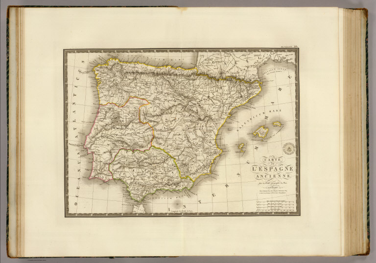
Brue, Adrien Hubert, 1786-1832
Full Title
Carte de l'Espagne ancienne, par A. Brue, Geographe du Roi. Paris, 1827. Chez l'Auteur, rue des Macons-Sorbonne, no. 9, et chez les principaux marchands de cartes geographiques.
List No
0096.010
Note
Hand colored engraved map. Relief shown by hachures. Prime meridian: Paris.
Author
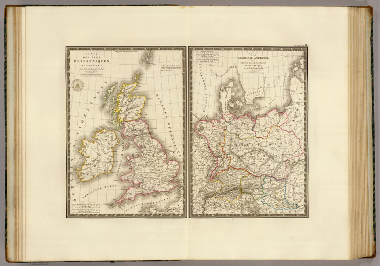
Brue, Adrien Hubert, 1786-1832
Full Title
Carte des Iles Britanniques anciennes par A. Brue ... Carte de la Germanie ancienne, de la Rhetie, de la Pannonie et du Norique par A. Brue, Geographe du Roi ... Paris, 1827. Chez l'Auteur, rue des Macons-Sorbonne, no. 9, et chez les principaux m(archan)ds de cartes geographiques.
List No
0096.011
Note
Two hand colored engraved maps. Relief shown by hachures. Scale of Germanie ancienne is ca. 1:5,200,000. Prime meridian: Paris.
Author
Brue, Adrien Hubert, 1786-1832
Full Title
Carte de la Russie occidentale et du Royme. de Pologne par A. Brue, Geographe du Roi. Paris, 1827. Chez l'Auteur, rue des Macons-Sorbonne, no. 9, et chez les principaux m(archan)ds de cartes geographiques.
List No
0096.023
Note
Hand colored engraved map. Relief shown by hachures.
Author
Brue, Adrien Hubert, 1786-1832
Full Title
Carte particuliere de l'Angleterre, de la Principaute de Galles et de la partie meridionale de l'Ecosse; indiquant toutes les principales routes et les canaux navigables. Par A. Brue, Geographe du Roi. Paris, 1827. Chez l'Auteur, rue des Macons-Sorbonne, no. 9, et chez les principaux m(archan)ds de cartes geographiques.
List No
0096.025
Note
Hand colored engraved map. Relief shown by hachures. Prime meridian: Paris.
Author
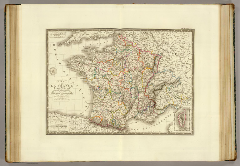
Brue, Adrien Hubert, 1786-1832
Full Title
Carte de la France a l'epoque de 1789, indiquant les divisions comparatives des anciennes provinces et des departements actuels. Par A. Brue, Geographe du Roi. Paris, 1827. Chez l'Auteur, rue des Macons-Sorbonne, no. 9, et chez les principaux marchands de cartes geographiques.
List No
0096.027
Note
Hand colored engraved map. Relief shown by hachures. Prime meridian: Paris. Includes inset map of Corsica.
Author
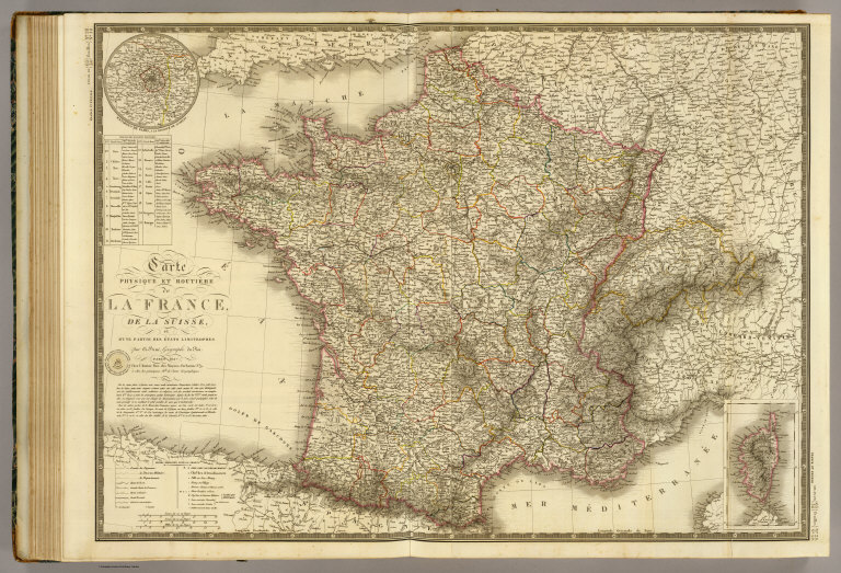
Brue, Adrien Hubert, 1786-1832
Full Title
Carte physique et routiere de la France, de la Suisse, et d'une partie des etats limitrophes par A. Brue, Geographe du Roi. Paris, 1827. Chez l'Auteur, rue des Macons-Sorbonne, no. 9, et chez les principaux m(archan)ds de cartes geographiques.
List No
0096.028
Note
Hand colored engraved map. Relief shown by hachures. Prime meridian: Paris. Shows canals, bishoprics, archbishoprics, forts, mineral baths, etc. Includes inset maps of Corsica and "Environs de Paris a la distance de 12 lieues." Originally issued in 2 sheets.
Author
Brue, Adrien Hubert, 1786-1832
Full Title
Carte de l'Allemagne comprenant les etats de la Confederation Germanique excepte une partie des monarchies autrichienne et prussienne. Par A. Brue, Geographe du Roi. Paris, 1827. Chez l'Auteur, rue des Macons-Sorbonne, no. 9, et chez les principaux marchands de cartes geographiques.
List No
0096.032
Note
Hand colored engraved map. Relief shown by hachures. Prime meridian: Paris.
Author
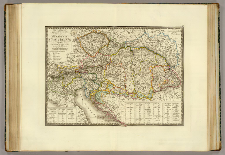
Brue, Adrien Hubert, 1786-1832
Full Title
Carte generale physique et routiere de la Monarchie Autrichienne dressee par A. Brue, Geographe du Roi. Paris, 1827. Chez l'Auteur, rue des Macons-Sorbonne, no. 9, et chez les principaux m(archan)ds de cartes geographiques.
List No
0096.034
Note
Hand colored engraved map. Relief shown by hachures. Prime meridian: Paris.
Author
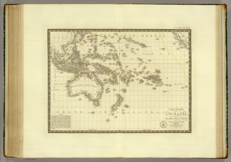
Brue, Adrien Hubert, 1786-1832
Full Title
Carte generale de l'Oceanie ou cinquieme partie du Monde, par A. Brue, Geographe du Roi. Paris, 1827. Chez l'Auteur, rue des Macons-Sorbonne, no. 9, et chez les principaux m(archan)ds de cartes geographiques.
List No
0096.047
Note
Hand colored engraved map. Relief shown by hachures. Prime meridian: Paris.
Author
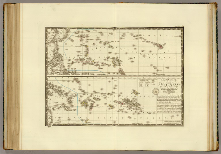
Brue, Adrien Hubert, 1786-1832
Full Title
Carte particuliere de la Polynesie, (partie de l'Oceanie). Redigee par A. Brue, Geographe du Roi d'apres l'ensemble des materiaux recueillis jusque ce jour. Paris, 1826. Chez l'Auteur, rue des Macons-Sorbonne, no. 9, et chez les principaux marchands de cartes geographiques. Augmentee par l'Auteur en 1827.
List No
0096.050
Note
Hand colored engraved map. Relief shown by hachures. Prime meridian: Paris.
Author
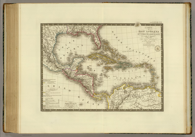
Brue, Adrien Hubert, 1786-1832
Full Title
Carte des Iles-Antilles ou Indes Occidentales, du Golfe du Mexique et d'une partie des pays adjacents; par A. Brue, Geographe du Roi. Paris, 1825. Chez l'Auteur, rue des Macons Sorbonne, no. 9, et chez les principaux marchands de geographie. Revue en 1827.
List No
0096.061
Note
Hand colored engraved map. Relief shown by hachures. Prime meridian: Paris.
Author
[Chaucheprat, Depot General de la Marine]
Full Title
Plan de la Baie de la Conception. Leve en 1825, dans la cours de la Compagne de la Fregate La Marie Therese, par M. Chaucheprat, Lieutenant de Vaisseau. Publie par ordre du Roi. Sous le Ministere de Son Excellence M. le Comte Chabrol de Crousol, Pair de France, Secretaire d'Etat au Departement de la Marine et des Colonies. Au Depot-generale de la Marine en 1827. Grave par Caplin. Ecrit par Besancon.
List No
0233.032
Note
Engraved map. Relief shown by hachures; soundings in brasses francaises. Includes "Vue de l'Ile Quiriquina prise du mouillage" and "avertissement." "No. 337." Logo of the Depot in lower left corner.
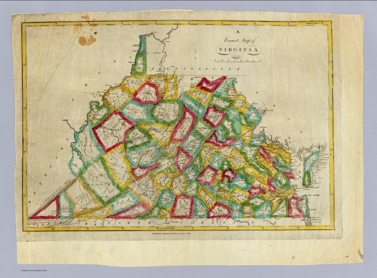
Author
DeSilver, Robert
Full Title
A correct map of Virginia. Philadelphia: Published by Robert De Silver, 1827.
List No
0236.000
Note
Updated from M. Carey's 1818 edition General Atlas. Many changes to the Carey plate in the western part of the state -- changes in the mountains, rivers, counties, and towns. DeSilver's imprint below map. Map has outline color by county. Relief shown by hachures. Prime meridians: Philadelphia and London.
|
![Covers: [Un libro de mapas.]](https://media.davidrumsey.com/MediaManager/srvr?mediafile=/Size3/RUMSEY~8~1/199/14368001.jpg)