|
Author
[Depot General de la Marine, Beautemps-Beaupré, Charles François, 1766-1854]
Full Title
Des Cotes De France (Partie Comprise Entre Le Raz De Sein Et Lorient)
List No
15934.128
Note
Hydrographie Française 3
Author
[Depot General de la Marine, Beautemps-Beaupré, Charles François, 1766-1854]
Full Title
Carte Particuliere Des Cotes De France (Iles De Glenan, Baie De La Forest, Anse De Benodet Et Partie Des Roches De Penmarch)
List No
15934.129
Note
Hydrographie Française 3
Author
[Depot General de la Marine, Beautemps-Beaupré, Charles François, 1766-1854]
Full Title
Plan De L'Entree De L'Odet (Riviere de Quimper)
List No
15934.130
Note
Hydrographie Française 3
Author
[Depot General de la Marine, Beautemps-Beaupré, Charles François, 1766-1854]
Full Title
Plan De Concarneau
List No
15934.132
Note
Hydrographie Française 3
Author
Depot General de la Marine
Full Title
Carte Particuliere Des Cotes De France (Entree Du Port De Lorent, Ile De Groix, Anse Du Pouldu, Entree De L'Aven Et Basse Jaune
List No
15934.133
Note
Hydrographie Française 3
Author
Depot General de la Marine
Full Title
Plan Des Passes Et Rades De Lorient Et De Port-Louis
List No
15934.134
Note
Hydrographie Française 3
Author
[Depot General de la Marine, MacKenzie, Murdoch]
Full Title
Plan Des Rades Ste Helene, Spithead, et des Ports Portsmouth et Langstone
List No
15934.061
Note
Hydrographie Française 2
Author
[Depot General de la Marine, MacKenzie, Murdoch]
Full Title
Plan De La Partie Occidentale Du Canal qui separe L'Ile De Wight, De La Cote De Hampshire.
List No
15934.065
Note
Hydrographie Française 2
Author
[Depot General de la Marine, MacKenzie, Murdoch]
Full Title
Plan De La Cote Sud De L'Ile De Wight
List No
15934.066
Note
Hydrographie Française 2
Author
[Depot General de la Marine, MacKenzie, Murdoch]
Full Title
Plan De La Cote Meridionale D'Angleterre Depuis la Pt Blackwood de L'Ile de Wight jusqu'a St. Albans Head.
List No
15934.067
Note
Hydrographie Française 2
Author
[Depot General de la Marine, MacKenzie, Murdoch]
Full Title
Plan De La Cote Meridionale D'Angleterre Depuis St Alban Head jusqu'a Abbotsbury.
List No
15934.068
Note
Hydrographie Française 2
Author
[Depot General de la Marine, MacKenzie, Murdoch]
Full Title
Plan De La Cote Meridionale D'Angleterre Depuis Abbotsbury.jusqu'a Sidmouth.
List No
15934.069
Note
Hydrographie Française 2
Author
[Depot General de la Marine, MacKenzie, Murdoch]
Full Title
Carte De La Cote Meridionale D'Angleterre Depuis Plymouth jusqu'au Cap Lizard
List No
15934.072
Note
Hydrographie Française 2
Author
[Depot General de la Marine, Thomas, George]
Full Title
Plan Du Port De Fowey
List No
15934.074
Note
Hydrographie Française 2
Author
Depot General de la Marine
Full Title
Carte Generale De L'Ocean Atlantique ou Occidental
List No
15934.002
Note
Hydrographie Française 1
Author
Dallas, George M.
Full Title
[Discussing The Recovery of John Melish's Map of Pennsylvania] Autograph Letter Signed, "George M. Dallas," to Auditor General David Mann
List No
15637.000
Author
Depot De La Guerre (France)
Full Title
(Covers to) Carte Topographique De L'Ile De Corse Dressee Par Ordre Du Roi, D'Apres Les Operations Geodesiques det les Levees Du Cadstre executes de 1770 a 1791 et diriges Par Feu M. M. Testevuide et Bedigis . . . M.DCCC.XXIV
List No
15503.001
Author
Depot De La Guerre (France)
Full Title
(Sheet 1) Carte Topographique De L'Ile De Corse Dressee Par Ordre Du Roi, D'Apres Les Operations Geodesiques det les Levees Du Cadstre executes de 1770 a 1791 et diriges Par Feu M. M. Testevuide et Bedigis . . . M.DCCC.XXIV
List No
15503.002
Author
Depot De La Guerre (France)
Full Title
(Sheet 2) Carte Topographique De L'Ile De Corse Dressee Par Ordre Du Roi, D'Apres Les Operations Geodesiques det les Levees Du Cadstre executes de 1770 a 1791 et diriges Par Feu M. M. Testevuide et Bedigis . . . M.DCCC.XXIV
List No
15503.003
Author
Depot De La Guerre (France)
Full Title
(Sheet 3) Carte Topographique De L'Ile De Corse Dressee Par Ordre Du Roi, D'Apres Les Operations Geodesiques det les Levees Du Cadstre executes de 1770 a 1791 et diriges Par Feu M. M. Testevuide et Bedigis . . . M.DCCC.XXIV
List No
15503.004
Author
Depot De La Guerre (France)
Full Title
(Sheet 4) Carte Topographique De L'Ile De Corse Dressee Par Ordre Du Roi, D'Apres Les Operations Geodesiques det les Levees Du Cadstre executes de 1770 a 1791 et diriges Par Feu M. M. Testevuide et Bedigis . . . M.DCCC.XXIV
List No
15503.005
Author
Depot De La Guerre (France)
Full Title
(Sheet 5) Carte Topographique De L'Ile De Corse Dressee Par Ordre Du Roi, D'Apres Les Operations Geodesiques det les Levees Du Cadstre executes de 1770 a 1791 et diriges Par Feu M. M. Testevuide et Bedigis . . . M.DCCC.XXIV
List No
15503.006
Author
Depot De La Guerre (France)
Full Title
(Sheet 6) Carte Topographique De L'Ile De Corse Dressee Par Ordre Du Roi, D'Apres Les Operations Geodesiques det les Levees Du Cadstre executes de 1770 a 1791 et diriges Par Feu M. M. Testevuide et Bedigis . . . M.DCCC.XXIV
List No
15503.007
Author
Depot De La Guerre (France)
Full Title
(Sheet 7) Carte Topographique De L'Ile De Corse Dressee Par Ordre Du Roi, D'Apres Les Operations Geodesiques det les Levees Du Cadstre executes de 1770 a 1791 et diriges Par Feu M. M. Testevuide et Bedigis . . . M.DCCC.XXIV
List No
15503.008
Author
Depot De La Guerre (France)
Full Title
(Sheet 8) Carte Topographique De L'Ile De Corse Dressee Par Ordre Du Roi, D'Apres Les Operations Geodesiques det les Levees Du Cadstre executes de 1770 a 1791 et diriges Par Feu M. M. Testevuide et Bedigis . . . M.DCCC.XXIV
List No
15503.009
Author
Depot De La Guerre (France)
Full Title
(Composite Map to) (Sheets 1-8) Carte Topographique De L'Ile De Corse Dressee Par Ordre Du Roi, D'Apres Les Operations Geodesiques det les Levees Du Cadstre executes de 1770 a 1791 et diriges Par Feu M. M. Testevuide et Bedigis . . . M.DCCC.XXIV
List No
15503.011
Author
Depot De La Guerre (France)
Full Title
(Composite Map to) (Sheets 1-8) Carte Topographique De L'Ile De Corse Dressee Par Ordre Du Roi, D'Apres Les Operations Geodesiques det les Levees Du Cadstre executes de 1770 a 1791 et diriges Par Feu M. M. Testevuide et Bedigis . . . M.DCCC.XXIV
List No
15503.010
Author
Berghaus, Heinrich, 1797-1884
Full Title
Frankreich, mit besonderer Rücksicht auf die Unebenheiten im Maasstabe von 1:2.000.000 [France, with special attention to the unevenness on a scale of 1:2,000,000]
List No
15232.000
Author
Kongelige Danske Søkort-Arkiv
Full Title
(Composite map of) Six coastal charts of Iceland by the Kongelige Danske Søkort-Arkiv. Laid on top of the general chart of Iceland, our 10983.000
List No
10990.000
Author
Kongelige Danske Søkort-Arkiv
Full Title
Voxende Kaart over den ostlige Kyst af Jisland fra Mulehavn i Hierrads-Floin-Bugt til Ingolfs-Hofde-Huk . . . 1824
List No
10985.000
Note
Updated to 1892.
Author
Arrowsmith, Aaron
Full Title
(Covers to) Chart of the East India Islands, Exhibiting the several Passages between the Indian and Pacific Oceans; Inscribed to the Commanders and Officers of the British Ships Navigating those Seas, by A. Arrowsmith. 1824. Published February 10th, 1824 by A. & S. Arrowsmith, No. 10 Soho Square.
List No
10495.001
Note
In four large sheets. Map of Southeast Asia showing the coasts of Burma, Thailand, Malaysia, Indonesia, Vietnam, Philippines and West Papua. Depth shown by bathymetric soundings. Prime meridian: Greenwich. This issue appeared twelve years after the 1812 issue, see our 6711.000. Originally published in 1800.
Author
Arrowsmith, Aaron
Full Title
(NW sheet of) Chart of the East India Islands, Exhibiting the several Passages between the Indian and Pacific Oceans; Inscribed to the Commanders and Officers of the British Ships Navigating those Seas, by A. Arrowsmith. 1824. Published February 10th, 1824 by A. & S. Arrowsmith, No. 10 Soho Square.
List No
10495.002
Note
In four large sheets. Map of Southeast Asia showing the coasts of Burma, Thailand, Malaysia, Indonesia, Vietnam, Philippines and West Papua. Depth shown by bathymetric soundings. Prime meridian: Greenwich. This issue appeared twelve years after the 1812 issue, see our 6711.000. Originally published in 1800.
Author
Arrowsmith, Aaron
Full Title
(Composite map of) NW, NE, SE, SW sheets. Chart of the East India Islands, Exhibiting the several Passages between the Indian and Pacific Oceans; Inscribed to the Commanders and Officers of the British Ships Navigating those Seas, by A. Arrowsmith. Additions to 1812. engraved by S.I. Neele, 352 Strand.
List No
10495.006
Note
In four large sheets. Map of Southeast Asia showing the coasts of Burma, Thailand, Malaysia, Indonesia, Vietnam, Philippines and West Papua. Depth shown by bathymetric soundings. Prime meridian: Greenwich. This issue appeared twelve years after the 1812 issue, see our 6711.000. Originally published in 1800.
Author
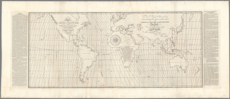
Yeates, Thomas
Full Title
Chart of the variation of the magnetic needle, for all the known seas comprehended within sixty degreees of latitude north and south, with a new and accurate delineation of the magnetic meridians. Accompanied with suitable remarks and illustrations by Thomas Yeates. Drawn & engraved by J. Walker. Published as the Act directs, by Thos. Yeates 22d. Augt. 1817 & republished by J.W. Norie & Co., 1824.
List No
13120.000
Note
Second edition of Thomas Yeates important chart of the World showing magnetic variations, which extended the work of Edmund Halley to the Pacific Ocean and other previously uncharted regions. An important improvement on Edmond Halley's chart of 1701. Halley's charts became obsolete and were updated by William Mountaine and James Dodson in 1744 and 1756, relying upon Halley's model, with modified Isogonal lines. As noted by Yeates in his historical text, the chart was again updated in 1794. In 1817, with financial assistance from Trinity House, Yeates created the first significant modification to Halley's basic model, extending the Isogonal lines to include the Pacific Ocean and covering the world from 60 Degrees North to 60 Degrees South Latitude. Marginal historical and explanatory notes are listed in the left panel where Yeates provides a short synopsis of the history of magnetism from its discovery by the Chinese. In the right text panel, Yeates gives a lengthy explanation of the "Deductions and Experiments Made by Capt. M. Flinders Relating to the Variation of the magnetic Needle". Prime meridian is Greenwich. Map includes explanatory notes and compass roses.
Author
Lohrmann, Wilhelm Gotthelf
Full Title
(Title Page to) Topographie der Sichtabaren Mondoberflache von William Gotthelf Lohrmann; Inspector Bei Der K.S. Cameral-Vermessung. Erste Abtheilung mit VI kupfertafeln. Auf kosten des Verfassers. Dresden bei Demselben. leipzig Bei Joh. friedr. Hartknoch. 1824. (cover title) Topographie der sichtbaren Mondoberflache. Erste Abtheilung.
List No
11245.004
Note
First edition lunar atlas with 6 copperplate engraved plates, of which 4 comprise sections of a moon map, by Lohrmann a professional cartographer and surveyor who undertook a lunar map based on his own micrometric measurements. Using a small Fraunhofer refractor, he determined the exact position of a number of control points on the moon, from which the positions of all other lunar features could be determined. He divided his map into twenty-four sections, and in 1824 he published the first four of these sections, along with an explanation of his methods. Although he worked for sixteen more years, and finished drawing all the sections, Lohrmann never did publish the remainder of the atlas. Fortunately, his great successor, Julius Schmidt, completed Lohrmann's atlas and published it in 1878. 'One of the most attractive features of Lohrmann's maps is the use of multiple levels of shading to indicate light and dark areas of the moon' (Ashworth). Includes hachures to indicate the length and steepness of the slopes of the various features and shadings to indicate the light and dark areas of the moo
Author
Lohrmann, Wilhelm Gotthelf
Full Title
Mondcharte. Sect: I. Gest. v. Borger unter Leit. v. Krille. Beob. u. gez. v. W. G. Lohrmann. (to accompany) Topographie der Sichtabaren Mondoberflache von William Gotthelf Lohrmann.
List No
11245.012
Note
Copperplate engraved map of the moon.
Author
Lohrmann, Wilhelm Gotthelf
Full Title
Mondcharte. Sect: II. Gest. v. G. Borger und G. Zumpe. Beob. u. gez. v. W. G. Lohrmann. (to accompany) Topographie der Sichtabaren Mondoberflache von William Gotthelf Lohrmann.
List No
11245.013
Note
Copperplate engraved map of the moon.
Author
Lohrmann, Wilhelm Gotthelf
Full Title
Mondcharte. Sect: III. Gest. v. G. Borger u. Hajeck. Beob. u. gez. v. W. G. Lohrmann. (to accompany) Topographie der Sichtabaren Mondoberflache von William Gotthelf Lohrmann.
List No
11245.014
Note
Copperplate engraved map of the moon.
Author
Lohrmann, Wilhelm Gotthelf
Full Title
Mondcharte. Sect: IV. Gest. v. G. Borger und G. Zumpe. Beob. u. gez. v. W. G. Lohrmann. (to accompany) Topographie der Sichtabaren Mondoberflache von William Gotthelf Lohrmann.
List No
11245.015
Note
Copperplate engraved map of the moon.
Author
Lohrmann, Wilhelm Gotthelf
Full Title
(Composite map of) Mondcharte. Sect:I- IV. Gest. v. G. Borger und G. Zumpe. Beob. u. gez. v. W. G. Lohrmann. (to accompany) Topographie der Sichtabaren Mondoberflache von William Gotthelf Lohrmann.
List No
11245.016
Note
Composite of all the sheets of Mondcharte.
Author
[Humboldt, Alexander von, 1769-1859, Bonpland, Aime, Marchais, F., Kunth, Montufar, Carlos]
Full Title
IX. Voyage vers la cime du Chimborazo, tenete le 24 juin 1802. Geographie des plantes dans les Andes de Quito.
List No
12125.031
Author
[Finley, Anthony, Vance, David H.]
Full Title
New Map of the United States. Anthony Finley ... Proposes to publish, by subscription, A New and Elegant Map of the United States. Philadelphia, March 27th, 1824.
List No
3961B
Note
Proposal for subscribers. The map was published in 1825 (see our copy, #3961001). This proposal also was published in the back of the 1824 General Atlas, first issue (see our copy, #2680). Pub. Note gives details about the map itself.
Author
[Arrowsmith, Aaron, Alaskan Boundary Tribunal]
Full Title
(Facsimile) Map of America (northwest portion) by A. Arrowsmith, Hydrographer to His Majesty, 1822. Additions to 1824.
List No
0009.009
Note
Tinted boundaries. Relief shown by hachures.
Author
[Faden, William, 1750?-1836, Alaskan Boundary Tribunal]
Full Title
(Facsimile) Map of North America (portion) from 20 to 80 Degrees North Latitude Exhibiting the recent Discoveries, Geographical and Nautical; Drawn chiefly from the Authorities M. de Humbolt (Humboldt), Lieut; Pike. Mess. Lewis and Clarke. Sir Alexr. Mackenzie. Mr. Hearne, Col. Bouchette, Capt. Vancouver, Ross, Parry & Franklin also Describing the Boundary Lines between the Territories of Great Britain & Spain with the United States. London. Published by Ja. Wyld (successor to W. Faden) N.5. Charing Cross, Geographer to His Majesty and to H.R.H. the Duke of York, June 1, 1824. Photo. Lith. by A. Hoen & Co. Baltimore, MD. (by Faden).
List No
0009.012
Note
Color tinted boundaries. Relief shown by hachures.
Author
[Alaskan Boundary Tribunal, Arrowsmith]
Full Title
(Facsimile) Arrowsmith's North America (northwestern portion).
List No
0009.013
Note
Includes map of and notes on Mackenzies River. Color tinted boundaries. Relief shown by hachures.
Author
Delamarche, Felix
Full Title
Iles Britanniques ... 1824.
List No
0231.007
Author
Delamarche, Felix
Full Title
Russie D'Europe Partie Septentrionale ... 1824.
List No
0231.009
Author
Delamarche, Felix
Full Title
Russie D'Europe Partie Meridionale ... 1924.
List No
0231.010
Author
Delamarche, Felix
Full Title
Royaume des Pas-Bas Divise en ses 18 Provinces ... 1824.
List No
0231.013
Author
Delamarche, Felix
Full Title
Afrique Divisee en ses principaux Etats ... 1824.
List No
0231.021
|


![[Discussing The Recovery of John Melish's Map of Pennsylvania] Autograph Letter Signed, "George M. Dallas," to Auditor General David Mann](https://media.davidrumsey.com/MediaManager/srvr?mediafile=/Size3/RUMSEY~8~1/205/15637000.jpg)


![Frankreich, mit besonderer Rücksicht auf die Unebenheiten im Maasstabe von 1:2.000.000 [France, with special attention to the unevenness on a scale of 1:2,000,000]](https://www.davidrumsey.com/rumsey/Size2/RUMSEY~8~1/199/15232000.jpg)