|
Author
[Depot General de la Marine, Beautemps-Beaupré, Charles François, 1766-1854]
Full Title
Carte Particuliere De La Chaussee De Sein Et Du Passage Du Raz De Sein
List No
15934.123
Note
Hydrographie Française 3
Author
[Depot General de la Marine, Ryk, M.J.C.]
Full Title
Carte Particuliere Des Passes Du Texel Et De La Rade Du Helder.
List No
15934.037
Note
Hydrographie Française 1
Author
[Barker, Henry Aston, Burford, Robert]
Full Title
(Covers to) Description of the view of Venice, taken, and painted by Messrs. Barker and Burford, from the Piazza di S. Marco : with a representation of the carnival : now exhibiting in their Panorama, Strand
List No
15930.001
Author
[Barker, Henry Aston, Burford, Robert]
Full Title
(Title page to) Description of the view of Venice, taken, and painted by Messrs. Barker and Burford, from the Piazza di S. Marco : with a representation of the carnival : now exhibiting in their Panorama, Strand
List No
15930.002
Author
[Barker, Henry Aston, Burford, Robert]
Full Title
Description of the view of Venice, taken, and painted by Messrs. Barker and Burford, from the Piazza di S. Marco : with a representation of the carnival : now exhibiting in their Panorama, Strand
List No
15930.003
Author
[Barker, Henry Aston, Burford, Robert]
Full Title
(Composite text to) Description of the view of Venice, taken, and painted by Messrs. Barker and Burford, from the Piazza di S. Marco : with a representation of the carnival : now exhibiting in their Panorama, Strand
List No
15930.004
Author
Journeaux
Full Title
(Covers to) Nouveau Plan Routier de la Ville et Faubourgs Paris Divise en Douze Mairie Annee 1819. Chez Journeaux l'aine, Md. d'Estampes, Hotel des Monnaies A Paris. Dep. a la direction de l'Imprimerie et de la Librairie.
List No
0697.001
Author
Journeaux
Full Title
Nouveau Plan Routier de la Ville et Faubourgs Paris Divise en Douze Mairie Annee 1819. Chez Journeaux l'aine, Md. d'Estampes, Hotel des Monnaies A Paris. Dep. a la direction de l'Imprimerie et de la Librairie.
List No
0697.002
Author
Borghi, Bartolomeo, 1750-1821
Full Title
A: Bartolommeo Borghi. G. Canacci Inc.
List No
14255.003
Note
Portrait of Atlante generale author, Borghi Bartolommeo by Giuseppe Canacci. 29 x 22 cm, on sheet 47 x 35 cm.
Author
[Roussin, Albin-Reine, baron, 1781-1854, Givry, Depot General de la Marine, Besançon]
Full Title
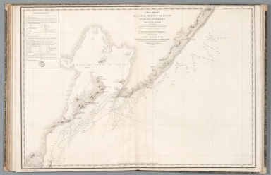
Carte réduite de la Côte du Brésil comprise entre l'Ile Santa Catharina et le Cap Frio levée en 1819, dans la Campagne de la Corvette la Bayadère et du Brick le Favori, par Mm. Givry, Ingénieur Hydrographe de la Marine, Chevalier de la Légion d'Honneur, et les Officiers des deux Batimens, sous les Ordres et la Direction de M. le Baron Roussin, Capitane de Vaisseau, Officier de la Légion d'Honneur, Chevalier de St. Louis et de St. Wolodimir de Russie, Chef de l'Expédition. Publiée par Ordre du Roi sous le Ministère de Son Exc. M. le Marquis de Clermont-Tonnerre Pair de France, Secrétaire d'Etat au Département de la Marine et des Colonies. Au Dépôt général de la Marine, 1822. Dessinée par M. Givry et gravée par M. Ambroise Tardieu ; ecrit par Besançon.
List No
14364.030
Note
Map of the Brazilian coast, from Santa Catarina Island to Cabo Frio, as surveyed in 1819. Shows cities, ports, topography, drainage, coastline, bays, shoals, islands, depths, routes and anchorage. Relief shown with hachures. Includes latitudinal and longitudinal lines. With descriptive text and the seal of "Dépòt General de la Marine". Black and white engraving. Map is 58 x 89 cm, on double sheet 66 x 100 cm. Appears in Deuxième partie.
Author
[Roussin, Albin-Reine, baron, 1781-1854, Givry, Depot General de la Marine, Besançon]
Full Title
Plan du mouillage situé au nord-ouest de l'Ile Santa Catharina à la Côte du Brésil levé en 1819, dans la Campagne de la Corvette la Bayadère et du Brick le Favori, par Mm. Givry, Ingénieur Hydrographe de la Marine, Chevalier de la Légion d'Honneur et les Officiers de la Corvette, sous les Ordres et la Direction de M. le Baron Roussin, Capitane de Vaisseau, Officier de la Légion d'Honneur, Chevalier de St. Louis et de St. Wolodimir de Russie, Chef de l'Expédition. Publiée par Ordre du Roi sous le Ministère de Son Exc. M. le Marquis de Clermont Tonnerre Pair de France, Secrétaire d'Etat au Département de la Marine et des Colonies. Au Dépôt général de la Marine, 1822. Dessinée par M. Givry et gravée par M. Ambroise Tardieu ; ecrit par Besançon.
List No
14364.031
Note
Map of the anchorage located northwest of Santa Catarina on the Brazilian coast, as surveyed in 1819. Shows cities, forts, ports, topography, vegetation, drainage, coastline, bays, shoals, islands, depths, routes and anchorage. Relief shown with hachures. Includes latitudinal and longitudinal lines, as well as a bar scale given in "toises" [= fathoms] and compass rose with north oriented toward top of sheet. With descriptive text and the seal of "Dépòt General de la Marine". Black and white engraving. Map is 87 x 58 cm, on double sheet 100 x 66 cm. Appears in Deuxième partie.
Author
[Roussin, Albin-Reine, baron, 1781-1854, Givry, Gressier, Charles-Louis, 1791-1886, Depot General de la Marine, Besançon]
Full Title
Carte particulière des environs de l'Ile Sn. Sebastiaõ à la Côte du Brésil levée en 1819, dans la Campagne de la Corvette la Bayadère et du Brick le Favori, par Mm. Givry et Gressier, Ingénieurs-Hydrographe de la Marine et les Officiers des deux Batimens, sous les Ordres et la Direction de M. le Baron Roussin, Capitane de Vaisseau, Officier de la Légion d'Honneur, Chevalier de St. Louis et de St. Wolodimir de Russie, Chef de l'Expédition. Publiée par Ordre du Roi sous le Ministère de Son Exc. M. le Marquis de Clermont-Tonnerre Pair de France, Secrétaire d'Etat au Département de la Marine et des Colonies. Au Dépôt-général de la Marine, 1823. Gravé par M. Ambroise Tardieu ; ecrit par Besançon.
List No
14364.032
Note
Map of the environs of the island São Sebastião, Brazil, as surveyed in 1819. Shows cities, ports, topography, vegetation, drainage, coastline, bays, shoals, islands, depths, routes and anchorage. Relief shown with hachures. Includes latitudinal and longitudinal lines, as well as a bar scale given in "milles marins" [= nautical miles]. With descriptive text and the seal of "Dépòt General de la Marine". Inset map: Plan du mouillage de l'Ile Sn. Sebastião levé en 1819 ... Black and white engraving. Map is 58 x 89 cm, on double sheet 66 x 100 cm. Appears in Deuxième partie.
Author
[Roussin, Albin-Reine, baron, 1781-1854, Givry, Depot General de la Marine, Besançon]
Full Title
Carte réduite de la Côte du Brésil comprise entre le Cap Frio et Porto Seguro levée en 1819, dans la Campagne de la Corvette la Bayadère et du Brick le Favori, par Mm. Givry, Ingénieur-Hydrographe de la Marine, Chevalier de la Légion d'Honneur, et les Officiers des deux Batimens, sous les Ordres et la Direction de M. le Baron Roussin, Capitane de Vaisseau, Officier de la Légion d'Honneur, Chevalier de St. Louis et de St. Wolodimir de Russie, Chef de l'Expédition. Publiée par Ordre du Roi sous le Ministère de Son Exc. M. le Marquis de Clermont-Tonnerre Pair de France, Secrétaire d'Etat au Département de la Marine et des Colonies. Au Dépôt-général de la Marine, 1824. Dessinée par M. Givry et gravée par M. Ambroise Tardieu ; ecrit par Besançon.
List No
14364.033
Note
Map of the Brazilian coast between Cabo Frio and Porto Seguro, as surveyed in 1819. Shows cities, ports, topography, vegetation, drainage, coastline, bays, shoals, islands, depths, routes and anchorage. Relief shown with hachures. Includes latitudinal and longitudinal lines. With descriptive text and the seal of "Dépòt General de la Marine". Black and white engraving. Map is 89 x 59 cm, on double sheet 100 x 66 cm. Appears in Deuxième partie.
Author
[Roussin, Albin-Reine, baron, 1781-1854, Givry, Gressier, Charles-Louis, 1791-1886, Depot General de la Marine, Besançon]
Full Title
Plan de la Baie de Espirito Santo située à la Côte du Brésil, levé en 1819, dans la Campagne de la Corvette la Bayadère et du Brick le Favori, par Mm. Givry et Gressier, Ingénieurs-Hydrographe de la Marine et les Officiers des deux Batimens, sous les Ordres et la Direction de M. le Baron Roussin, Capitane de Vaisseau, Officier de la Légion d'Honneur, Chevalier de St. Louis et de St. Wolodimir de Russie, Chef de l'Expédition. Publiée par Ordre du Roi sous le Ministère de Son Exc. M. le Marquis de Clermont-Tonnerre Pair de France, Secrétaire d'Etat au Département de la Marine et des Colonies. Au Dépôt-général de la Marine, 1823. Gravé par M. Ambroise Tardieu ; ecrit par Besançon.
List No
14364.034
Note
Map of the Bay of Espírito Santo, on the Brazilian coast, as surveyed in 1819. Shows cities, forts, ports, topography, vegetation, drainage, coastline, bays, shoals, islands, depths, routes and anchorage. Relief shown with hachures. Includes a bar scale given in "milles marins" [= nautical miles]. With descriptive text and the seal of "Dépòt General de la Marine". Black and white engraving. Map is 42 x 58 cm, on sheet 50 x 66 cm. Appears in Deuxième partie.
Author
[Roussin, Albin-Reine, baron, 1781-1854, Givry, Depot General de la Marine, Besançon]
Full Title
Carte réduite des Ilots et du Canal des Abrolhos situés à la Côte du Brésil, levée en 1819, dans la Campagne de la Corvette la Bayadère et du Brick le Favori, par Mm. Givry, Ingénieur-Hydrographe de la Marine, Chevalier de la Légion d'Honneur, et les Officiers de la Corvette, sous les Ordres et la Direction de M. le Baron Roussin, Capitane de Vaisseau, Officier de la Légion d'Honneur, Chevalier de St. Louis et de St. Wolodimir de Russie, Chef de l'Expédition. Publiée par Ordre du Roi sous le Ministère de Son Exc. M. le Marquis de Clermont-Tonnerre Pair de France, Secrétaire d'Etat au Département de la Marine et des Colonies. Au Dépôt-général de la Marine, 1822. Gravé par M. Ambroise Tardieu ; ecrit par Besançon.
List No
14364.035
Note
Map of the Abrolhos Archipelago, on the Brazilian coast, as surveyed in 1819. Shows topography, vegetation, drainage, coastline, bays, shoals, islands, depths, routes and anchorage. Relief shown with hachures. Includes latitudinal and longitudinal lines, as well as a bar scale given in "toises" [= fathoms]. With descriptive text and the seal of "Dépòt General de la Marine". Inset map: Plan des Ilots Abrolhos. Black and white engraving. Map is 58 x 89 cm, on double sheet 66 x 100 cm. Appears in Deuxième partie.
Author
[Roussin, Albin-Reine, baron, 1781-1854, Givry, Depot General de la Marine, Besançon]
Full Title
Carte réduite de la Côte du Brésil comprise entre Porto Seguro et Pernambuco levée en 1819, dans la Campagne de la Corvette la Bayadère et du Brick le Favori, par Mm. Givry, Ingénieur-Hydrographe de la Marine, Chevalier de la Légion d'Honneur, et les Officiers des deux Batimens, sous les Ordres et la Direction de M. le Baron Roussin, Capitane de Vaisseau, Officier de la Légion d'Honneur, Chevalier de St. Louis et de St. Wolodimir de Russie, Chef de l'Expédition. Publiée par Ordre du Roi sous le Ministère de Son Excellence M. le Comte Carbol de Crousol Pair de France, Secrétaire d'Etat au Département de la Marine et des Colonies. Au Dépôt-général de la Marine, 1825. Gravé par M. Ambroise Tardieu ; ecrit par Besançon.
List No
14364.036
Note
Map of the Brazilian coast between Porto Seguro and Pernambuco, as surveyed in 1819. Shows cities, ports, topography, vegetation, drainage, coastline, bays, shoals, islands, depths, routes and anchorage. Relief shown with hachures. Includes latitudinal and longitudinal lines. With descriptive text and the seal of "Dépòt General de la Marine". Black and white engraving. Map is 89 x 59 cm, on double sheet 100 x 66 cm. Appears in Deuxième partie.
Author
[Roussin, Albin-Reine, baron, 1781-1854, Givry, Depot General de la Marine, Besançon]
Full Title
Carte réduite de la Baie de Todos os Santos et de ses attérages situés à la Côte du Brésil, levée en 1819, dans la Campagne de la Corvette la Bayadère et du Brick le Favori, par Mm. Givry, Ingénieur-Hydrographe de la Marine, Chevalier de la Légion d'Honneur, et les Officiers de la Corvette, sous les Ordres et la Direction de M. le Baron Roussin, Capitane de Vaisseau, Officier de la Légion d'Honneur, Chevalier de St. Louis et de St. Wolodimir de Russie, Chef de l'Expédition. Publiée par Ordre du Roi sous le Ministère de Son Exc. M. le Marquis de Clermont-Tonnerre Pair de France, Secrétaire d'Etat au Département de la Marine et des Colonies. Au Dépôt-général de la Marine, 1822. Gravé par M. Ambroise Tardieu ; ecrit par Besançon.
List No
14364.037
Note
Map of the Baía de Todos os Santos [All Saints Bay], Brazil, as surveyed in 1819. Shows cities, ports, topography, vegetation, drainage, coastline, bays, shoals, islands, depths, routes and anchorage. Relief shown with hachures. Includes latitudinal and longitudinal lines. With descriptive text and the seal of "Dépòt General de la Marine". Black and white engraving. Map is 61 x 90 cm, on double sheet 66 x 100 cm. Appears in Deuxième partie.
Author
[Roussin, Albin-Reine, baron, 1781-1854, Givry, Depot General de la Marine, Besançon]
Full Title
Carte réduite de la Rade de Pernambuco et de ses attérages situés à la Côte du Brésil, levée en 1819, dans la Campagne de la Corvette la Bayadère et du Brick le Favori, par Mm. Givry, Ingénieur-Hydrographe de la Marine, Chevalier de la Légion d'Honneur, et les Officiers de la Corvette, sous les Ordres et la Direction de M. le Baron Roussin, Capitane de Vaisseau, Officier de la Légion d'Honneur, Chevalier de St. Louis et de St. Wolodimir de Russie, Chef de l'Expédition. Publiée par Ordre du Roi sous le Ministère de Son Excellence M. le Comte Charbol de Crousol Pair de France, Secrétaire d'Etat au Département de la Marine et des Colonies. Au Dépôt-général de la Marine, en 1824. Dessinés par M. Givry et gravés par M. Ambroise Tardieu ; ecrit par Besançon.
List No
14364.038
Note
Map of Pernambuco, Brazil, as surveyed in 1819. Shows cities, ports, topography, vegetation, drainage, coastline, bays, shoals, islands, depths, routes and anchorage. Relief shown with hachures. Includes latitudinal and longitudinal lines. With descriptive text and the seal of "Dépòt General de la Marine". Black and white engraving. Map is 59 x 43 cm, on sheet 66 x 50 cm. Appears in Deuxième partie.
Author
[Roussin, Albin-Reine, baron, 1781-1854, Gressier, Charles-Louis, 1791-1886, Givry, Depot General de la Marine, Besançon]
Full Title
Plan de la Rade de Pernambuco levé en 1819, dans la Campagne de la Corvette la Bayadère et du Brick le Favori, par Mm. Gressier, Ingénieur-Hydrographe de la Marine, et les Officiers du Brick, sous les Ordres et la Direction de M. le Baron Roussin, Capitane de Vaisseau, Officier de la Légion d'Honneur, Chevalier de St. Louis et de St. Wolodimir de Russie, Chef de l'Expédition. Publiée par Ordre du Roi sous le Ministère de Son Excellence M. le Comte Charbol de Crousol Pair de France, Secrétaire d'Etat au Département de la Marine et des Colonies. Au Dépôt-général de la Marine, en 1824. Dessinés par M. Givry et gravés par M. Ambroise Tardieu ; ecrit par Besançon.
List No
14364.039
Note
Map of Pernambuco, Brazil, as surveyed in 1819. Shows cities, forts, ports, topography, vegetation, drainage, coastline, bays, shoals, islands, depths, routes and anchorage. Relief shown with hachures. Includes latitudinal and longitudinal lines, as well as a bar scale given in "milles marins" [= nautical miles] and compass rose with north oriented toward top of sheet. With descriptive text and the seal of "Dépòt General de la Marine". Black and white engraving. Map is 55 x 44 cm, on sheet 66 x 50 cm. Appears in Deuxième partie.
Author
[Roussin, Albin-Reine, baron, 1781-1854, Givry, Depot General de la Marine, Besançon]
Full Title
Carte réduite de la Côte du Brésil comprise entre Pernambuco et Ciará, levée en 1819, dans la Campagne de la Corvette la Bayadère et du Brick le Favori, par Mm. Givry, Ingénieur-Hydrographe de la Marine, Chevalier de la Légion d'Honneur, et les Officiers des deux Batimens, sous les Ordres et la Direction de M. le Baron Roussin, Capitane de Vaisseau, Officier de la Légion d'Honneur, Chevalier de St. Louis et de St. Wolodimir de Russie, Chef de l'Expédition. Publiée par Ordre du Roi sous le Ministère de Son Excellence M. le Comte Charbol de Crousol Pair de France, Secrétaire d'Etat au Département de la Marine et des Colonies. Au Dépôt-général de la Marine, 1826. Gravé par M. Ambroise Tardieu ; ecrit par Besançon.
List No
14364.040
Note
Map of the Brazilian coast between Pernambuco and "Ciará", as surveyed in 1819. Shows cities, ports, topography, vegetation, drainage, coastline, bays, shoals, islands, depths, routes and anchorage. Relief shown with hachures. Includes latitudinal and longitudinal lines. With descriptive text and the seal of "Dépòt General de la Marine". Black and white engraving. Map is 58 x 88 cm, on double sheet 66 x 100 cm. Appears in Deuxième partie.
Author
Borghi, Bartolomeo, 1750-1821
Full Title
(Covers to) Borghi, Atlante, Firenze, MDCCCXIX.
List No
14255.001
Note
Covers to Atlante generale. Bound in vellum-covered board, with marbled pattern. Abbreviated atlas title is gilded along spine, with authorship, and publication place and year, in Roman numerals.
Author
Borghi, Bartolomeo, 1750-1821
Full Title
(Title Page to) Atlante generale dell'Ab. Bartolomeo Borghi, corredato di prospetti istorici-politici-civili-naturali di ciascheduno stato. Publicato a spese di Rosa Parigi, e del cre. Giulio Cesare Bertolini sotto la ditta Aristide Parigi e compo. e dai medesimi dedicato alla loro patria. Firenze 1819.
List No
14255.002
Note
Title plate to Atlante generale. Includes title, authorship and imprint, all in ornamental script. Title translates to: [General atlas].
Author
Borghi, Bartolomeo, 1750-1821
Full Title
(Index Page to) Indice e classazione delle Carte geografiche e dei prospette istorici politici civili e naturali che compongono il presente atlante. Firenze 1819 Nella Stamperia Granducale (1).
List No
14255.004
Note
Index to Atlante generale. First of two plates (3-4). Title translates to: [Index and classification of the geographical maps and of the civil and natural, political, historical prospectus that make up this atlas]. Includes one introduction by the publishers and another by the author. Imprint at bottom right.
Author
Borghi, Bartolomeo, 1750-1821
Full Title
(Index Page to) Indice e classazione delle Carte geografiche e dei prospette istorici politici civili e naturali che compongono il presente atlante. Firenze 1819 Nella Stamperia Granducale (2).
List No
14255.005
Note
Index to Atlante generale. Second of two plates (3-4). Title translates to: [Index and classification of the geographical maps and of the civil and natural, political, historical prospectus that make up this atlas]. Includes descriptive text. Imprint at bottom right.
Author
Borghi, Bartolomeo, 1750-1821
Full Title
Sistema planetario come si conosce in oggi. Firenze 1819.
List No
14255.006
Note
Engraved black and white celestial map showing the sun and planets scaled to each other, in both size and distance from the sun. Title translates to: [Planetary system as it is known today. Planets shown: Mercury, Venus, Earth (and moon), Mars, Jupiter, Saturn and Uranus. Includes two bar scales. Imprint beneath title. Map is 30 x 23 cm, on sheet 47 x 35 cm.
Author
Borghi, Bartolomeo, 1750-1821
Full Title
Carta sferica : Sfera parallela -- Sfera retta -- Sfera obliqua -- Sfera obliqua -- Per la latitudime, dell'A. B. Borghi. Firenze 1819. Ago. Costa Ic.
List No
14255.007
Note
Engraved black and white map showing four different ways to dissect the globe: with lines parallel, straight, and oblique (in two different orientations). In addition, lines of latitude are shown. Each of these five methods is represented by a sphere. The demonstration of latitude includes a small spherical map of the Eastern Hemisphere. Titles translate to: [Parallel sphere -- Straight sphere -- Oblique sphere -- Oblique sphere -- For latitude]. Imprint beneath title. Map is 23 x 30 cm, on sheet 35 x 47 cm.
Author
Borghi, Bartolomeo, 1750-1821
Full Title
Mappa mondo emisfero antico, dell'A. B. Borghi. Firenze 1817. Ago. Costa Inc.
List No
14255.008
Note
Engraved spherical, historical map of the Eastern Hemisphere, depicting the ancient world, with hand-colored outlines delineating boundaries. Title translates to: [Ancient hemisphere world map]. Shows political boundaries, topography, drainage, coastlines and islands. Relief shown pictorially. With latitudinal and longitudinal lines. One in a pair of hemisphere maps, which continues on next plate (8). Imprint beneath title. Map is 25 x 32 cm, on sheet 35 x 47 cm.
Author
Borghi, Bartolomeo, 1750-1821
Full Title
Mappa mondo emisfero nuovo, dell'A. B. Borghi. Firenze 1819. A. Costa F.
List No
14255.009
Note
Engraved spherical, historical map of the Western Hemisphere, depicting the ancient world, with hand-colored outlines delineating boundaries. Title translates to: [New hemisphere world map]. Shows political boundaries, topography, drainage, coastlines and islands. Relief shown pictorially. With latitudinal and longitudinal lines. One in a pair of hemisphere maps, continued from prior plate (7). Imprint beneath title. Map is 25 x 33 cm, on sheet 35 x 47 cm.
Author
Borghi, Bartolomeo, 1750-1821
Full Title
(Text Page to) Prospetto generale dell'Europa par servire d'illustrazione alla Carte della medesima inserita nell'Atlante dell'A. B. Borghi. Firenze 1819. Nella Stamperia Granducale.
List No
14255.010
Note
Descriptive text accompanying the subsequent map of Europe on following plate (10. Title translates to: [General prospectus of Europe ... ]. Includes a table with empires and corresponding capitals, such as Berlin for Prussia. Imprint at bottom right.
Author
Borghi, Bartolomeo, 1750-1821
Full Title
L'Europa, dell'A. B. Borghi. Firenze 1818. Ago. Costa Inc.
List No
14255.011
Note
Engraved political map of Europe, with hand-colored outlines delineating boundaries. Title translates to: [Europe]. Shows political boundaries, topography, drainage, coastlines and islands. Relief shown pictorially. With latitudinal and longitudinal lines. Imprint beneath title. Map is 23 x 29 cm, on sheet 35 x 47 cm. Descriptive text appears on prior plate (9).
Author
Borghi, Bartolomeo, 1750-1821
Full Title
(Text Page to) Prospetto Istorico-Politico-Civile-Naturale del regno di Svezia, compilato secondo il sistema dei moderni Geografi, e destinato per l'intelligenza delle Carte della Svezia, dell'A. B. Borghi. Firenze. Presso Niccolò Carli 1816.
List No
14255.012
Note
Descriptive text accompanying the subsequent map of Sweden on plates 13-14. Title translates to: [Historical-political-civil-natural prospectus of the Kingdom of Sweden ... ]. Includes a table with political divisions. Imprint at bottom center.
Author
Borghi, Bartolomeo, 1750-1821
Full Title
(Text Page to) Prospetto Istorico-Politico-Civile-Naturale della Norvega, ora riunita al Regno di Svezia, compilato secondo il sistema dei moderni Scrittori di Geografia, e destinato per l'intelligenza del Terzo supplemento alla Carte della Svezia dell'A. B. Borghi. Firenze 1816. Presso Giovanni Marenigh.
List No
14255.013
Note
Descriptive text accompanying the subsequent maps of Norway on plates 15-16. Title translates to: [Historical-political-civil-natural prospectus of Norway, now reunited with the Kingdom of Sweden ... ]. Imprint at bottom center.
Author
Borghi, Bartolomeo, 1750-1821
Full Title
La Svezia come era nella sua prima divisione, e secondo gli ultimi trattati, dell'A. B. Borghi. Firenze 1816.
List No
14255.014
Note
Engraved political map of Sweden, with hand-colored outlines delineating boundaries. Title translates to: [Sweden as it was in its first division, and according to the latest treaties]. Shows political boundaries, topography, drainage, coastlines and islands. Relief shown pictorially. With latitudinal and longitudinal lines, as well as two bar scales. Imprint beneath title. First in a series of four maps (plates 13-16). Map is 30 x 22 cm, on sheet 47 x 35 cm. Descriptive text appears on prior plate (11).
Author
Borghi, Bartolomeo, 1750-1821
Full Title
La Svezia Novissima, del A. B. Borghi. Firenze 1818. Ago. Costa Inc.
List No
14255.015
Note
Engraved political map of Sweden, with hand-colored outlines delineating boundaries. Title translates to: [Sweden, most recently]. Shows political boundaries, topography, drainage, coastlines and islands. Relief shown pictorially. With latitudinal and longitudinal lines, as well as two bar scales. Imprint beneath title. Second in a series of four maps (plates 13-16). Map is 30 x 22 cm, on sheet 47 x 35 cm. Descriptive text appears on prior plate (11).
Author
Borghi, Bartolomeo, 1750-1821
Full Title
Norvegia : Secondo supplemento alla Carte generale della Svezia, ossia la Svezia Meridionale, divisa secondo il presente sistema politico del Regno, dell A. B. Borghi. Firenze 1816.
List No
14255.016
Note
Engraved political map of Norway, with hand-colored outlines delineating boundaries. Title translates to: [Norway : Second supplement to the general map of Sweden, namely Southern Sweden, divided according to the present political system of the Kingdom]. Shows political boundaries, topography, drainage, coastlines, islands and routes of travel. Relief shown pictorially. With latitudinal and longitudinal lines, as well as two bar scales. Imprint beneath title. Third in a series of four maps (plates 13-16). Map is 30 x 22 cm, on sheet 47 x 35 cm. Descriptive text appears on prior plate (12).
Author
Borghi, Bartolomeo, 1750-1821
Full Title
Terzo supplemento alla Carte di Svezia, contenente la Norvegia, la di cui parte Settentrionale e'stata es pressa da capo a sinistra in scala la metà minore, composizione dell'A. B. Borghi. Firenze 1816.
List No
14255.017
Note
Engraved political map of Norway, with hand-colored outlines delineating boundaries. Title translates to: [Third supplement to the map of Sweden, containing Norway ..]. Shows political boundaries, topography, drainage, coastlines and islands. Relief shown pictorially. With latitudinal and longitudinal lines, as well as two bar scales. Imprint beneath title. Fourth in a series of four maps (plates 13-16). Map is 30 x 22 cm, on sheet 47 x 35 cm. Descriptive text appears on prior plate (12).
Author
Borghi, Bartolomeo, 1750-1821
Full Title
Text: Prospetto Istorico-Politico-Civile-Naturale dell'Impero di Russia per servire all'intelligenza delle Carte della Russia, dell'A. B. Borghi. Firenze 1818, Presso Giovanni Marenigh.
List No
14255.018
Note
Descriptive text accompanying the subsequent maps of the Russia Empire on plates 18-23. Title translates to: [Historical-political-civil-natural prospectus of the Empire of Russia ... ]. Imprint at bottom right.
Author
Borghi, Bartolomeo, 1750-1821
Full Title
Russia Europea, dell'A. B. Borghi. Firenze 1819.
List No
14255.019
Note
Engraved political map of the European portion of Russia, with hand-colored outlines delineating boundaries. Title translates to: [European Russia]. Shows political boundaries, topography, drainage, coastlines and islands. Relief shown pictorially. With latitudinal and longitudinal lines. Imprint beneath title. Map is 31 x 25 cm, on sheet 47 x 35 cm. Descriptive text appears on prior plate (17).
Author
Borghi, Bartolomeo, 1750-1821
Full Title
L'Impero Russo in Europa, in quattro fogli, dell'A. B. Borghi. Firenze 1817. Incisa nello Studio Giarre (1).
List No
14255.020
Note
Engraved political map of the Russian Empire in Europe, with hand-colored outlines delineating boundaries. Title translates to: [The Russian Empire in Europe]. Shows political boundaries, topography, drainage, coastlines, islands and routes of travel. Relief shown pictorially. With latitudinal and longitudinal lines, as well as two bar scales and a descriptive note. Imprint beneath title. First (northeast) in a series of four sheets that together comprise the full map (plates 19-22). Sheet is 30 x 22 cm, on sheet 47 x 35 cm. Descriptive text appears on prior plate (17).
Author
Borghi, Bartolomeo, 1750-1821
Full Title
L'Impero Russo in Europa, in quattro fogli, dell'A. B. Borghi. Firenze 1817. Incisa nello Studio Giarre (2).
List No
14255.021
Note
Engraved political map of the Russian Empire in Europe, with hand-colored outlines delineating boundaries. Title (from first sheet, on plate 19) translates to: The Russian Empire in Europe]. Shows political boundaries, topography, drainage, coastlines, islands and routes of travel. Relief shown pictorially. With latitudinal and longitudinal lines. Additionally, includes two bar scales and a descriptive note on first sheet. Second (northwest) in a series of four sheets that together comprise the full map (plates 19-22). (Title and imprint taken from first sheet.) Sheet is 30 x 22 cm, on sheet 47 x 35 cm. Descriptive text appears on prior plate (17).
Author
Borghi, Bartolomeo, 1750-1821
Full Title
L'Impero Russo in Europa, in quattro fogli, dell'A. B. Borghi. Firenze 1817. Incisa nello Studio Giarre (3).
List No
14255.022
Note
Engraved political map of the Russian Empire in Europe, with hand-colored outlines delineating boundaries. Title (from first sheet, on plate 19) translates to: The Russian Empire in Europe]. Shows political boundaries, topography, drainage, coastlines and routes of travel. Relief shown pictorially. With latitudinal and longitudinal lines. Additionally, includes two bar scales and a descriptive note on first sheet. Third (southwest) in a series of four sheets that together comprise the full map (plates 19-22). (Title and imprint taken from first sheet.) Also, with inset: [Cracovia]. Sheet is 30 x 22 cm, on sheet 47 x 35 cm. Descriptive text appears on prior plate (17).
Author
Borghi, Bartolomeo, 1750-1821
Full Title
L'Impero Russo in Europa, in quattro fogli, dell'A. B. Borghi. Firenze 1817. Incisa nello Studio Giarre (4).
List No
14255.023
Note
Engraved political map of the Russian Empire in Europe, with hand-colored outlines delineating boundaries. Title (from first sheet, on plate 19) translates to: The Russian Empire in Europe]. Shows political boundaries, topography, drainage, coastlines, islands and routes of travel. Relief shown pictorially. With latitudinal and longitudinal lines. Additionally, includes two bar scales and a descriptive note on first sheet. Fourth (southeast) in a series of four sheets that together comprise the full map (plates 19-22). (Title and imprint taken from first sheet.) Also, with inset: [Cracovia]. Sheet is 29 x 22 cm, on sheet 47 x 35 cm. Descriptive text appears on prior plate (17).
Author
Borghi, Bartolomeo, 1750-1821
Full Title
(Composite Map to) L'Impero Russo in Europa, in quattro fogli, dell'A. B. Borghi. Firenze 1817. Incisa nello Studio Giarre.
List No
14255.024
Note
Composite map to L'Impero Russo in Europa ..., Engraved political map of the Russian Empire in Europe, with hand-colored outlines delineating boundaries. Title translates to: [The Russian Empire in Europe]. Shows political boundaries, topography, drainage, coastlines, islands and routes of travel. Relief shown pictorially. With latitudinal and longitudinal lines, as well as two bar scales and a descriptive note. Imprint beneath title. Map comprised of four sheets on plates 19-22. Also, with inset: [Cracovia]. Together, sheets are 58 x 44 cm, on sheets 95 x 70 cm. Descriptive text appears on prior plate (17).
Author
[Pawley, Neele, Samuel John, 1758-1824, Neele, George, Pinnock and Maunder]
Full Title
(Contents to) Index. Published Jany. 1st. 1819, by Pinnock & Maunder Strand.
List No
14326.003
Note
Table of contents to Pawley's minor atlas. Lists 43 map titles with associated plate numbers in Roman numerals. With an engraved image of sunbeams emanating from a cloud. Includes an imprint with a different publisher and date than stated on title page: Published Jany. 1st. 1819, by Pinnock & Maunder Strand.
Author
[Pawley, Neele, Samuel John, 1758-1824, Neele, George, Pinnock and Maunder]
Full Title
The world on Mercator's projection. Published Jany. 1st. 1819, by Pinnock & Co. Strand.
List No
14326.004
Note
World map on Mercator's projection. Shows continental boundaries, cities, topography, major lakes and drainage, coastlines and islands. Relief shown with hachures. Includes latitudinal and longitudinal lines, as well as a compass rose. Double plate, hand-colored engraving, including illustration of clouds behind title. Map is 27 x 41 cm, on sheet 34 x 49 cm.
Author
[Pawley, Neele, Samuel John, 1758-1824, Neele, George, Pinnock and Maunder]
Full Title
W. Hemisphere -- E. Hemisphere. Neele sculp. Published Jany. 1st. 1819, by Pinnock & Maunder Strand.
List No
14326.005
Note
Two maps, one of the Western and one of the Eastern Hemisphere, each in circular format. Maps show continental boundaries, cities, topography, major lakes and drainage, coastlines and islands. Relief shown with hachures. Each include latitudinal and longitudinal lines. Hand-colored engraving, including illustrations of clouds behind titles. Together, maps are 21 x 45 cm, on sheet 34 x 49 cm.
Author
[Pawley, Neele, Samuel John, 1758-1824, Neele, George, Pinnock and Maunder]
Full Title
N. Hemisphere -- S. Hemisphere. Neele sculp. Published Jany. 1st. 1819, by Pinnock & Maunder Strand.
List No
14326.006
Note
Two maps, one of the Northern and one of the Southern Hemisphere, each in circular format. Maps show continental boundaries, cities, topography, major lakes and drainage, coastlines and islands. Relief shown with hachures. Each include latitudinal and longitudinal lines. Hand-colored engraving, including illustrations of clouds behind titles. Together, maps are 21 x 45 cm, on sheet 34 x 49 cm.
Author
[Pawley, Neele, Samuel John, 1758-1824, Neele, George, Pinnock and Maunder]
Full Title
America. Neele sculp. Published Jany. 1st. 1819, by Pinnock & Maunder Strand.
List No
14326.039
Note
Map of the Americas and vicinity. Shows political boundaries, cities, railroads, topography, major lakes and drainage, coastlines and islands. Relief shown with hachures. Includes latitudinal and longitudinal lines, as well as a compass rose and bar scale, given in British miles. Hand-colored engraving, including illustration of clouds behind title. Map is 27 x 21 cm, on sheet 34 x 26 cm.
Author
[Pawley, Neele, Samuel John, 1758-1824, Neele, George, Pinnock and Maunder]
Full Title
N. America. Neele sculp. Published Jany. 1st. 1819, by Pinnock & Maunder Strand.
List No
14326.040
Note
Map of North America and vicinity. Shows political boundaries, cities, railroads, topography, major lakes and drainage, coastlines and islands. Features the indigenous peoples living therein, such as the Pawnees and Osages. Relief shown with hachures. Includes latitudinal and longitudinal lines, as well as a compass rose and bar scale, given in British miles. Hand-colored engraving, including illustration of clouds behind title. Map is 27 x 21 cm, on sheet 34 x 26 cm.
Author
[Pawley, Neele, Samuel John, 1758-1824, Neele, George, Pinnock and Maunder]
Full Title
Canada. Neele sculp. Published Jany. 1st. 1819, by Pinnock & Maunder Strand.
List No
14326.041
Note
Map of Canada and vicinity. Shows political boundaries, cities, railroads, topography, major lakes and drainage, coastlines and islands. Features the indigenous peoples living therein, such as the Mohawk. Relief shown with hachures. Includes latitudinal and longitudinal lines, as well as a compass rose and bar scale, given in British statute miles. Hand-colored engraving, including illustration of clouds behind title. Map is 27 x 21 cm, on sheet 34 x 26 cm.
Author
[Pawley, Neele, Samuel John, 1758-1824, Neele, George, Pinnock and Maunder]
Full Title
United States. Neele sculp. Published Jany. 1st. 1819, by Pinnock & Maunder Strand.
List No
14326.042
Note
Map of the United States and vicinity. One of the few 19th century maps to show the proposed state of Franklinia in eastern Tennessee. Shows political boundaries, cities, railroads, topography, major lakes and drainage, coastlines and islands. Features the indigenous peoples living therein, such as the Chicasaw. Relief shown with hachures. Includes latitudinal and longitudinal lines, as well as a compass rose and bar scale, given in British miles. Hand-colored engraving, including illustration of clouds behind title. Map is 22 x 27 cm, on sheet 26 x 34 cm.
Author
[Pawley, Neele, Samuel John, 1758-1824, Neele, George, Pinnock and Maunder]
Full Title
West Indies. Neele sculp. Published Jany. 1st. 1819, by Pinnock & Maunder Strand.
List No
14326.043
Note
Map of the West Indies and vicinity. Shows political boundaries, cities, railroads, topography, major lakes and drainage, coastlines and islands. Relief shown with hachures. Includes latitudinal and longitudinal lines, as well as a compass rose and bar scale, given in British statute miles. Descriptive text throughout, such as: These plains are overflowed in the rainy seasons. Hand-colored engraving, including illustration of clouds behind title. Map is 22 x 27 cm, on sheet 26 x 34 cm.
Author
[Pawley, Neele, Samuel John, 1758-1824, Neele, George, Pinnock and Maunder]
Full Title
S. America. Neele sculp. Published Jany. 1st. 1819, by Pinnock & Maunder Strand.
List No
14326.044
Note
Map of South America and vicinity. Shows political boundaries, cities, railroads, topography, major lakes and drainage, coastlines and islands. Relief shown with hachures. Includes latitudinal and longitudinal lines, as well as a compass rose and bar scale, given in British miles. Hand-colored engraving, including illustration of clouds behind title. Map is 28 x 21 cm, on sheet 34 x 26 cm.
Author
[Depot General de la Marine, Abel Dupetit - Thouars]
Full Title
Plan de la rade et du Barachois, des iles St. Pierre et Miquelon
List No
10709.000
Author
Dirwald, Joseph
Full Title
Charte von Nord America nach Arrowschmith, v. Humboldt und anderen verlaessigen Huelfsmitteln entworsen von Joseph Dirwald. 1819. Verlegt in Wien bey Tranquillo Mollo.
List No
12199.002
Author
Dirwald, Joseph
Full Title
Charte von Sued America nach Arrowsmith, v. Humboldt und anderen verlaessigen Huelfsmitteln entworsen von Joseph Dirwald. 1819. Verlegt in Wien bey Tranquillo Mollo.
List No
12200.002
Author
Faden, William, 1749-1836
Full Title
The World : Eastern Hemisphere. Published by W. Faden. Jany. 1819. Palmer Sculp. (to accompany) Atlas minimus universalis, or, A geographical abridgement ancient and modern of the several parts of the earth ... Second edition. Jan 1, 1821.
List No
13243.030
Note
Double page outline hand color copperplate engraved circular map on sheet 12x16. Includes manuscript log by Wilson inscribing his voyages to and from India around the map.
Author
Lapie, Pierre M., 1779-1850
Full Title
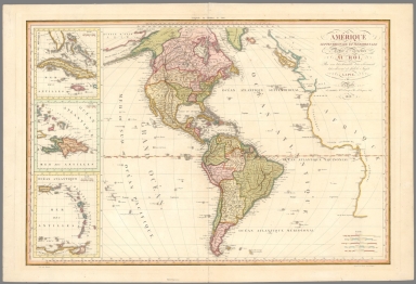
Amerique Septentrionale et Meridionale. Dediee et presentee au Roi. Par P. Lapie. Grave par Blondeau, graveur du Roi, et premier graveur du Depot de la Guerre. Paris ches Basset ... 1819. Ecrit par Rameau. Deposee au Bureau des Estampes. (insets) Ile de Cuba. (with) Ile Domingue. (with: Antilles).
List No
13029.000
Note
Hand colored engraved map of America with 3 inset maps of Cuba, Hispaniola and the lower Antilles, by Pierre Lapie, Engraved by Alexandre Blondeau. Shows political boundaries, major cities, towns, rivers and state boundaries. Relief shown by hachures. Pierre M. Lapie was an important cartographer and French engraver active in the early nineteenth century.
Author
Tanner, Henry Schenck
Full Title
An Authentic map of the world on the globular projection. Drawn by H. S. Tanner 1819. Engraved and published by Tanner, Vallance, Kearny & Co. no. 10 Library Street Philadela.
List No
13013.002
Note
Hand colored double hemisphere map of the world in round projections of the Western and Eastern hemispheres. on sheet 57.5x10³, dissected into 27 sections backed with linen, folded into marbled paper covers 19.5x12. Cartouche at top shows two young figures sitting outdoors with Egyptian pyramids seen in the distance. One figure kneels on the ground holding a compass and holds it to a spot on a map. Shows the routes of voyages made by Captain Cook and other explorers in the various oceans of the world. This is one of Tanner's earliest world maps and one of his earliest published maps.
Author
Baker, Harriet E.
Full Title
(Title Page to) Harriet E. Baker's Book of Penmanship & Maps. At Mr. Dunham's School Windsor Vermont March 31, 1819.
List No
8307.002
Note
The existence of this book of penmanship throws interesting light on our other book of penmanship by Frances Henshaw, our 2501.000. This book by Harriet Baker is dated four years earlier, 1819, and from another school in Windsor, Vermont (Henshaw's school was in Middlebury, Vermont). Generally, the two books follow very similar structure, both the text and the maps, which would indicate that the production of these books of penmanship was more frequent than previously thought and also suggests that there was a common template used, even by different schools, in their construction. It can be said that Baker's maps are exquisite, perhaps a bit more so than Henshaw's, but Henshaw's text descriptions of the states are more elaborate than Baker's. For some reason, Baker omits maps of New York, Pennsylvania, South Carolina, Kentucky, Indiana, Illinois and Michigan, while including descriptions of most of them. Henshaw has no map or description of Michigan or Illinois. For the sources of the maps and text, see our entry for Henshaw's book, 2501.000. The Osher Map Library has a copy of another book of penmanship, also from Mr. Dunham's School in Windsor Vermont, titled “Catharine M. Cook’s Book of Penmanship at Mr. Dunham’s School, Windsor, Vermont, June 15th, 1818”
Author
Baker, Harriet E.
Full Title
(Description of) New Hampshire. (to accompany) Harriet E. Baker's Book of Penmanship & Map. At Mr. Dunham's School Windsor Vermont March 31, 1819.
List No
8307.019
Note
A short description of the state of New Hampshire. Hand lettered text.
Author
Baker, Harriet E.
Full Title
New Hampshire. (to accompany) Harriet E. Baker's Book of Penmanship & Map. At Mr. Dunham's School Windsor Vermont March 31, 1819.
List No
8307.020
Note
Outline color map by county. Showing cities and towns, and rivers.
Author
Baker, Harriet E.
Full Title
(Description of) Connecticut. (to accompany) Harriet E. Baker's Book of Penmanship & Map. At Mr. Dunham's School Windsor Vermont March 31, 1819.
List No
8307.025
Note
A short description of the state of Connecticut surrounded by vines. Hand lettered text.
Author
Baker, Harriet E.
Full Title
Connecticut. (to accompany) Harriet E. Baker's Book of Penmanship & Map. At Mr. Dunham's School Windsor Vermont March 31, 1819.
List No
8307.026
Note
Outline color map by county. Showing cities and towns, and rivers. Relief shown by hachures.
Author
Baker, Harriet E.
Full Title
(Description of) New Jersey. (to accompany) Harriet E. Baker's Book of Penmanship & Map. At Mr. Dunham's School Windsor Vermont March 31, 1819.
List No
8307.031
Note
A short description of the state of New jersey. Hand lettered text.
Author
Baker, Harriet E.
Full Title
New Jersey. (to accompany) Harriet E. Baker's Book of Penmanship & Map. At Mr. Dunham's School Windsor Vermont March 31, 1819.
List No
8307.032
Note
Outline color map by county, with decorative cartouche. Showing cities and towns, and rivers. Relief shown by hachures.
Author
Adams, Daniel
Full Title
(Covers to) School atlas to Adams' Geography. Containing the following maps: ... Boston: Published by Lincoln & Edmands, No. 53 Cornhill. Sold by them and by the principal booksellers in the United States, 1819.
List No
0004A
Note
Cover title. With an oval vignette of a "Geographer" and his globe. Fine copy with original dust jacket. Publisher's advertisement on back cover.
Full Title
The World. Published by Lincoln & Edmands, (1819)
List No
0004.001
Note
Uncolored engraved double hemisphere map. Small ancillary maps: Zones -- Circles -- Parallels -- Meridians.
Full Title
North America. Published by Lincoln & Edmands, Boston, (1819)
List No
0004.002
Note
Uncolored engraved map. Relief shown pictorially.
Full Title
United States. (with) New England States. Wightman Sc. Published by Lincoln & Edmands, Boston, (1819)
List No
0004.003
Note
Uncolored engraved map with inset. Relief shown pictorially. Prime meridians: London and Philadelphia.
Full Title
South America. Published by Lincoln & Edmands, Boston, (1819)
List No
0004.004
Note
Uncolored engraved map. Relief shown pictorially.
Full Title
Europe. Published by Lincoln & Edmands, Boston, (1819)
List No
0004.005
Note
Uncolored engraved map. Relief shown pictorially. Engraver name erased from plate.
Full Title
British Isles. (with) Shetland Isles. Withington sculp. (Published by Lincoln & Edmands, 1819)
List No
0004.006
Note
Uncolored engraved map with inset.
Full Title
Asia. (Published by Lincoln & Edmands, 1819)
List No
0004.007
Note
Uncolored engraved map. Relief shown by hachures.
Full Title
Africa. (Published by Lincoln & Edmands, 1819)
List No
0004.008
Note
Uncolored engraved map. Relief shown pictorially.
Author
[Brue, Adrien Hubert, 1786-1832, Alaskan Boundary Tribunal]
Full Title
(Facsimile) Carte Encyprotype de L'Amerique Septentrionale (portion), Dedice et Presentee a Monsieur Par M. Brue, Ingenieur-Geographe de J.A. Royale a Paris. Chez Desray, Libraire-Editeur, Rue Haute-feuille, No. 4 pres celle St. Andre des Ares; (Chez) J. Goujon, Marchand de Cartes Geographiques, Rue de Bac, No. 6. (1815). Revue & Augmentee par l'Auteur en Avril 1819. Alaska Boundary Tribunal, 1903. 9. Photo. Lith. by A. Hoen & Co. Baltimore, MD.
List No
0009.052
Note
Tinted boundaries. Relief shown by hachures.
Author
Thomas, David, 1776-1859
Full Title
(Title Page to) Travels through the western country in the summer of 1816. Including notices of the natural history, antiquities, topography, agriculture, commerce and manufactures. With a map of the Wabash country, now settling. By David Thomas. Auburn, N.Y. Printed by David Rumsey. 1819.
List No
0995A
Note
Rebound in quarter leather with "Travels through the western country, David Thomas" on the spine in gold.
Author
Thomas, David, 1776-1859
Full Title
Vincennes district. Drawn by David Thomas. J. Ridley, Sc., N.Y.
List No
0995.001
Note
Engraved uncol. map. Shows rivers, counties, settlements, USPLSS townships, etc. Prime meridians: Washington and London. Covers southwesten Indiana.
Author
Wilkinson, Robert
Full Title
Canaan or the Land of Promise to Abraham and his Posterity.
List No
1203.006
Author
Wilkinson, Robert
Full Title
Places Recorded in the Five Books of Moses. (inset) The Eastern Countries as Mentioned by Moses.
List No
1203.007
Author
Wilkinson, Robert
Full Title
Canaan from the Time of Joshua to the Babylonish Captivity.
List No
1203.009
Author
Wilkinson, Robert
Full Title
The Purveyorships in the Reign of Solomon, I. Kings, Chap 4.
List No
1203.011
Author
Wilkinson, Robert
Full Title
The Land of Moriah or Jerusalem and the Adjacent Country.
List No
1203.058
Author
Wilkinson, Robert
Full Title
The Countries Travelled by the Apostles.
List No
1203.012
Author
Wilkinson, Robert
Full Title
Succession of Bishops with the alterations of Dioceses at different Times in England since the arrival of Augustin in 597 with their Contemporary Sovereigns.
List No
1203.022
Note
Fold-out.
Author
Wilkinson, Robert
Full Title
Aegyptus Antiqua.
List No
1203.024
Author
Wilkinson, Robert
Full Title
Graecia Pars Septentrionalis aliter Macedonia, Thessalia & Epirus cum Thracia.
List No
1203.033
Author
Wilkinson, Robert
Full Title
Palaestina seu Terra Sancta.
List No
1203.041
Author
[Wilkinson, Robert, Rennell, James, 1742-1830]
Full Title
The World according to the Idea of Herodotus as far as can be collected from his History, Copied from Major Rennell with Permission.
List No
1203.047
Author
Bourne, E.
Full Title
Saxon England.
List No
1203.055
Author
Dirwald, Joseph
Full Title
(Covers to) Charte von Nord America nach Arrowschmith, v. Humboldt und anderen verlaessigen Huelfsmitteln entworsen von Joseph Dirwald. 1819. Verlegt in Wien bey Tranquillo Mollo.
List No
12199.001
Note
Light green slipcase and wrapper with marbled paper covers. Text on front, "Vienne chez Tranquillo Mollo. Place St. Michel, No. 262."
Author
Dirwald, Joseph
Full Title
(Covers to) Charte von Sued America nach Arrowsmith, v. Humboldt und anderen verlaessigen Huelfsmitteln entworsen von Joseph Dirwald. 1819. Verlegt in Wien bey Tranquillo Mollo.
List No
12200.001
Note
Light green slipcase and wrapper with marbled paper covers. Text on front, "Vienne chez Tranquillo Mollo. Place St. Michel, No. 262."
Author
Tanner, Henry Schenck
Full Title
(Covers to) An Authentic map of the world on the globular projection. Drawn by H. S. Tanner 1819. Engraved and published by Tanner, Vallance, Kearny & Co. no. 10 Library Street Philadela.
List No
13013.001
Note
Hand colored double hemisphere map of the world in round projections of the Western and Eastern hemispheres. on sheet 57.5x10³, dissected into 27 sections backed with linen, folded into marbled paper covers 19.5x12. Cartouche at top shows two young figures sitting outdoors with Egyptian pyramids seen in the distance. One figure kneels on the ground holding a compass and holds it to a spot on a map. Shows the routes of voyages made by Captain Cook and other explorers in the various oceans of the world. This is one of Tanner's earliest world maps and one of his earliest published maps.
Author
Faden, William, 1749-1836
Full Title
Orbis Veteribus Notus. Published by W. Faden. Jany 1, 1819. T.C. Conder, sculp. (to accompany) Atlas minimus universalis, or, A geographical abridgement ancient and modern of the several parts of the earth ... Second edition. Jan 1, 1821.
List No
13243.016
Note
Double page outline hand color engraved map. Show the Ancient World during the time of the Ancient Roman Empire, including Asia, Europe and Africa. Relief shown pictorially.
Author
Faden, William, 1749-1836
Full Title
(Text Page to) Atlas minimus universalis, or, A geographical abridgement ancient and modern of the several parts of the earth : in fifty-eight maps composed principally for the use of schools, &c. Published by Wm. Faden, Geographer tp His Majesty. Second edition. Jan 1, 1821.
List No
13243.017
Note
Continues: Manuscript log by Wilson inscribing his voyages to and from India.
Author
Faden, William, 1749-1836
Full Title
Orbis Romani Pars Occidentalis. Published by W. Faden. Jany 1, 1819. Hatchett, sc. (to accompany) Atlas minimus universalis, or, A geographical abridgement ancient and modern of the several parts of the earth ... Second edition. Jan 1, 1821.
List No
13243.018
Note
Double page outline hand color engraved map of the western part of the Roman Empire. Show towns, mountains, rivers, lakes, bays, islands, etc. Relief shown pictorially.
Author
Faden, William, 1749-1836
Full Title
Orbis Romani Pars Orientalis. Published by W. Faden. Jany 1, 1819. Hatchett, sc. (to accompany) Atlas minimus universalis, or, A geographical abridgement ancient and modern of the several parts of the earth ... Second edition. Jan 1, 1821.
List No
13243.019
Note
Double page outline hand color engraved map of the Eastern part of the Roman Empire. Show towns, mountains, rivers, lakes, bays, islands, etc. Relief shown pictorially.
Author
Faden, William, 1749-1836
Full Title
(Composite Map) Orbis Romani. Published by W. Faden. Jany 1, 1819. Hatchett, sc. (to accompany) Atlas minimus universalis, or, A geographical abridgement ancient and modern of the several parts of the earth ... Second edition. Jan 1, 1821.
List No
13243.020
Note
Composite map of the Roman Empire.
Author
Faden, William, 1749-1836
Full Title
Britanniae Facies Antiqua. Published by W. Faden. Jany 1, 1819. Hatchett, sc. (to accompany) Atlas minimus universalis, or, A geographical abridgement ancient and modern of the several parts of the earth ... Second edition. Jan 1, 1821.
List No
13243.021
Note
Double page outline hand color copperplate engraved ancient map of the British Isles. Relief shown pictorially.
Author
Faden, William, 1749-1836
Full Title
Galliae Antiquae Conspectus. Published by W. Faden. Jany 1, 1819. Hatchett, sc. (to accompany) Atlas minimus universalis, or, A geographical abridgement ancient and modern of the several parts of the earth ... Second edition. Jan 1, 1821.
List No
13243.022
Note
Double page outline hand color copperplate engraved ancient map of France. Relief shown pictorially.
Author
Faden, William, 1749-1836
Full Title
Hispania Vetus. Published by W. Faden. Jany 1, 1819. Foot Sculpt. (to accompany) Atlas minimus universalis, or, A geographical abridgement ancient and modern of the several parts of the earth ... Second edition. Jan 1, 1821.
List No
13243.023
Note
Double page outline hand color copperplate engraved map. Relief shown pictorially.
Author
Faden, William, 1749-1836
Full Title
Italiae Veteris Delineatio. Published by W. Faden. Jany 1, 1819. Hatchett, sc. (to accompany) Atlas minimus universalis, or, A geographical abridgement ancient and modern of the several parts of the earth ... Second edition. Jan 1, 1821.
List No
13243.024
Note
Double page outline hand color copperplate engraved map. Shows the major islands and includes some regions of Europe. Relief shown pictorially.
Author
Faden, William, 1749-1836
Full Title
Graeciae Antiquae et Aegaei Maris Tabula. Published by W. Faden. Jany 1, 1819. Palmer, sc. (to accompany) Atlas minimus universalis, or, A geographical abridgement ancient and modern of the several parts of the earth ... Second edition. Jan 1, 1821.
List No
13243.025
Note
Double page outline hand color copperplate engraved ancient map of Greece and Aegean Sea Region. Covers from Macedonia to the Peloponnesus. Relief shown pictorially.
Author
Faden, William, 1749-1836
Full Title
Brevis Asiae Minoris Descriptio. Published by W. Faden. Jany 1, 1819. Hatchett, sc. (to accompany) Atlas minimus universalis, or, A geographical abridgement ancient and modern of the several parts of the earth ... Second edition. Jan 1, 1821.
List No
13243.026
Note
Double page outline hand color copperplate engraved map. Relief shown pictorially.
Author
Faden, William, 1749-1836
Full Title
Palaestina quae et Chanaan et Terra Promissionis vel Terra Sancta. Published by W. Faden. Jany 1, 1819. Hatchett, sc. (to accompany) Atlas minimus universalis, or, A geographical abridgement ancient and modern of the several parts of the earth ... Second edition. Jan 1, 1821.
List No
13243.027
Note
Double page outline hand color copperplate engraved map, with insets: XII Tribus and Jerusalem. Shows major cities, mountain ranges, lakes, and rivers. Relief shown pictorially.
Author
Faden, William, 1749-1836
Full Title
Aegyptus Antiqua. Published by W. Faden. Jany 1, 1819. Hatchett, sc. (to accompany) Atlas minimus universalis, or, A geographical abridgement ancient and modern of the several parts of the earth ... Second edition. Jan 1, 1821.
List No
13243.028
Note
Double page outline hand color copperplate engraved ancient map of Egypt, with inset: Cheopis vel Chemnis quce et Major Pyramis. Shows major cities, mountain ranges, lakes, and rivers. Relief shown pictorially.
Author
Faden, William, 1749-1836
Full Title
Europe : According to the Treaty of Paris, 1815. Published by W. Faden. Jany. 1821. T. Starling Sculp. (to accompany) Atlas minimus universalis, or, A geographical abridgement ancient and modern of the several parts of the earth ... Second edition. Jan 1, 1821.
List No
13243.034
Note
Double page outline hand color copperplate engraved map. Shows political boundaries.
Author
Faden, William, 1749-1836
Full Title
United Kingdom of Great Britain and Ireland with the adjacent Islands. Published by W. Faden. Jany. 1,1819. W. Palmer sculp. (to accompany) Atlas minimus universalis, or, A geographical abridgement ancient and modern of the several parts of the earth ... Second edition. Jan 1, 1821.
List No
13243.035
Note
Double page outline hand color copperplate engraved map. Shows political boundaries. Prime meridian is London. Relief shown pictorially.
Author
Faden, William, 1749-1836
Full Title
England and Wales or South Britain. Published by W. Faden. Jany. 1,1819. W. Palmer sculp. (to accompany) Atlas minimus universalis, or, A geographical abridgement ancient and modern of the several parts of the earth ... Second edition. Jan 1, 1821.
List No
13243.036
Note
Double page outline hand color copperplate engraved map. Shows political boundaries. Prime meridian is London. Relief shown pictorially.
Author
Faden, William, 1749-1836
Full Title
Scotland or North Britain. Published by W. Faden. Jany. 1,1819. W. Palmer sculp. (to accompany) Atlas minimus universalis, or, A geographical abridgement ancient and modern of the several parts of the earth ... Second edition. Jan 1, 1821.
List No
13243.037
Note
Double page outline hand color copperplate engraved map, with inset: Shetland Isles. Shows administrative boundaries. Prime meridian is London. Relief shown pictorially.
Author
Faden, William, 1749-1836
Full Title
Ireland divided into provinces and counties. Published by Willm. Faden. Jany. 1,1819. Palmer sculp. (to accompany) Atlas minimus universalis, or, A geographical abridgement ancient and modern of the several parts of the earth ... Second edition. Jan 1, 1821.
List No
13243.038
Note
Double page outline hand color copperplate engraved map, Shows administrative boundaries. Prime meridian is London. Relief shown pictorially.
Author
Faden, William, 1749-1836
Full Title
France, divided into military governments as in 1700. Published by W. Faden. Jany. 1,1819. Palmer sculp. (to accompany) Atlas minimus universalis, or, A geographical abridgement ancient and modern of the several parts of the earth ... Second edition. Jan 1, 1821.
List No
13243.039
Note
Double page outline hand color copperplate engraved map, Shows administrative boundaries. Prime meridian is London. Relief shown pictorially.
Author
Faden, William, 1749-1836
Full Title
The Kingdom of France, according to the Treaty of Paris Novn. 20th. 1815. Published by W. Faden. Jany. 1,1819. Palmer sculp. (to accompany) Atlas minimus universalis, or, A geographical abridgement ancient and modern of the several parts of the earth ... Second edition. Jan 1, 1821.
List No
13243.040
Note
Double page outline hand color copperplate engraved map, Shows administrative boundaries. Prime meridian is London. Relief shown pictorially.
Author
Faden, William, 1749-1836
Full Title
The Kingdom of the Netherlands 1818. Published by W. Faden. Jany. 1,1819. Palmer sculp. (to accompany) Atlas minimus universalis, or, A geographical abridgement ancient and modern of the several parts of the earth ... Second edition. Jan 1, 1821.
List No
13243.041
Note
Double page outline hand color copperplate engraved map, Shows administrative boundaries. Prime meridian is Greenwich. Includes reference to administrative divisions.
Author
Faden, William, 1749-1836
Full Title
Denmark and Holstein. Published by W. Faden. Jany. 1,1819. Palmer sculp. (to accompany) Atlas minimus universalis, or, A geographical abridgement ancient and modern of the several parts of the earth ... Second edition. Jan 1, 1821.
List No
13243.042
Note
Double page outline hand color copperplate engraved map, Shows administrative boundaries. Prime meridian is London.
Author
Faden, William, 1749-1836
Full Title
Kingdom of Sweden including Norway. Published by W. Faden. Jany. 1,1819. (to accompany) Atlas minimus universalis, or, A geographical abridgement ancient and modern of the several parts of the earth ... Second edition. Jan 1, 1821.
List No
13243.043
Note
Double page outline hand color copperplate engraved map, Shows political boundaries. Prime meridian is London. Relief shown pictorially.
Author
Faden, William, 1749-1836
Full Title
Russian dominion in Europe : Including the Kingdom of Poland 1819. Published by W. Faden. Jany. 1,1819. D. Henwood, Sculp. (to accompany) Atlas minimus universalis, or, A geographical abridgement ancient and modern of the several parts of the earth ... Second edition. Jan 1, 1821.
List No
13243.044
Note
Double page outline hand color copperplate engraved map, Shows political boundaries. Prime meridian is Greenwich. Relief shown pictorially.
Author
Faden, William, 1749-1836
Full Title
The Kingdom of Poland with its ancient & present limits. 1819. Published by W. Faden. Jany. 1,1819. T. Starling, Sculp. (to accompany) Atlas minimus universalis, or, A geographical abridgement ancient and modern of the several parts of the earth ... Second edition. Jan 1, 1821.
List No
13243.045
Note
Double page outline hand color copperplate engraved map, Shows political boundaries. Relief shown pictorially. Note: "The outer red line describes the Ancient boundary, and the inner Do. its present limits ..."
Author
Faden, William, 1749-1836
Full Title
The Germanic States or Empire of Germany as in 1800. Published by W. Faden. Jany. 1,1819. W. Palmer, Sculp. (to accompany) Atlas minimus universalis, or, A geographical abridgement ancient and modern of the several parts of the earth ... Second edition. Jan 1, 1821.
List No
13243.046
Note
Double page outline hand color copperplate engraved map, Shows administrative boundaries. Relief shown pictorially. Prime meridian is London.
Author
Faden, William, 1749-1836
Full Title
The Kingdom of Hanover with the Grand Duchy of Mecklenburg 1818. Published by W. Faden. Jany. 1,1819. D. Henwood, Sculp. (to accompany) Atlas minimus universalis, or, A geographical abridgement ancient and modern of the several parts of the earth ... Second edition. Jan 1, 1821.
List No
13243.047
Note
Double page outline hand color copperplate engraved map, Shows administrative boundaries. Prime meridian is Greenwich.
Author
Faden, William, 1749-1836
Full Title
The Kingdom of Prussia as confirmed by the Treaty of Paris Novr. 20th. 1815. Published by W. Faden. Jany. 1,1819. D. Henwood, Sculp. (to accompany) Atlas minimus universalis, or, A geographical abridgement ancient and modern of the several parts of the earth ... Second edition. Jan 1, 1821.
List No
13243.048
Note
Double page outline hand color copperplate engraved map, with inset: Continuation of map. Shows administrative boundaries. Prime meridian is Greenwich.
Author
Faden, William, 1749-1836
Full Title
The Kingdom of Saxony, Bavaria, and Wirtemburg with adjacent states, 1818. Published by W. Faden. Jany. 1,1819. Engraved by D. Henwood. (to accompany) Atlas minimus universalis, or, A geographical abridgement ancient and modern of the several parts of the earth ... Second edition. Jan 1, 1821.
List No
13243.049
Note
Double page outline hand color copperplate engraved map. Shows administrative boundaries. Prime meridian is Greenwich. Relief shown pictorially.
Author
Faden, William, 1749-1836
Full Title
The Empire of Austria by the Treaty of Paris 1815. Published by W. Faden. Jany. 1,1819. D. Henwood, Sculp. (to accompany) Atlas minimus universalis, or, A geographical abridgement ancient and modern of the several parts of the earth ... Second edition. Jan 1, 1821.
List No
13243.050
Note
Double page outline hand color copperplate engraved map. Shows administrative boundaries. Prime meridian is Greenwich. Relief shown pictorially.
Author
Faden, William, 1749-1836
Full Title
Republic of Switzerland with the new limits. Published by W. Faden. Jany. 1,1819. Engd. by D. Henwood. (to accompany) Atlas minimus universalis, or, A geographical abridgement ancient and modern of the several parts of the earth ... Second edition. Jan 1, 1821.
List No
13243.051
Note
Double page outline hand color copperplate engraved map. Shows administrative boundaries. Prime meridian is Greenwich. Relief shown pictorially.
Author
Faden, William, 1749-1836
Full Title
Spain and Portugal. Published by W. Faden. Jany. 1,1819. Engd. by W. Palmer. (to accompany) Atlas minimus universalis, or, A geographical abridgement ancient and modern of the several parts of the earth ... Second edition. Jan 1, 1821.
List No
13243.052
Note
Double page outline hand color copperplate engraved map. Shows political and administrative boundaries. Prime meridian are Ferro and London. Relief shown pictorially. Includes manuscript log on right margin.
Author
Faden, William, 1749-1836
Full Title
Italy divided into its respective states. 1815. Published by W. Faden. Jany. 1,1819. W. Palmer, Sculp. (to accompany) Atlas minimus universalis, or, A geographical abridgement ancient and modern of the several parts of the earth ... Second edition. Jan 1, 1821.
List No
13243.053
Note
Double page outline hand color copperplate engraved map. Shows political and administrative boundaries. Prime meridian are Ferro and London. Relief shown pictorially. Includes note.
Author
Faden, William, 1749-1836
Full Title
The states of Upper Italy. Published by W. Faden. Jany. 1,1819. (to accompany) Atlas minimus universalis, or, A geographical abridgement ancient and modern of the several parts of the earth ... Second edition. Jan 1, 1821.
List No
13243.054
Note
Double page outline hand color copperplate engraved map. Shows administrative boundaries. Prime meridian is London. Relief shown pictorially. Includes note.
Author
Faden, William, 1749-1836
Full Title
Turkish Dominions in Europe, or European Turkey. Published by W. Faden. Jany. 1,1819. (to accompany) Atlas minimus universalis, or, A geographical abridgement ancient and modern of the several parts of the earth ... Second edition. Jan 1, 1821.
List No
13243.055
Note
Double page outline hand color copperplate engraved map. Shows administrative boundaries. Prime meridian is London. Relief shown pictorially. Includes manuscript log in upper margin.
Author
Faden, William, 1749-1836
Full Title
Greece and Archipelago with Part of Anadoli. Published by W. Faden. Jany. 1,1819. W. Palmer, Sculp. (to accompany) Atlas minimus universalis, or, A geographical abridgement ancient and modern of the several parts of the earth ... Second edition. Jan 1, 1821.
List No
13243.056
Note
Double page outline hand color copperplate engraved map. Shows political and administrative boundaries. Relief shown pictorially.
Author
Faden, William, 1749-1836
Full Title
Asia with the latest discoveries. Published by W. Faden. Jany. 1,1819. (to accompany) Atlas minimus universalis, or, A geographical abridgement ancient and modern of the several parts of the earth ... Second edition. Jan 1, 1821.
List No
13243.057
Note
Double page outline hand color copperplate engraved map. Shows political boundaries and exploration routes. Prime meridians are Ferro and London. Relief shown pictorially. Includes manuscript log in right margin.
Author
Faden, William, 1749-1836
Full Title
Russian Dominions in Asia. Published by W. Faden. Jany. 1,1819. (to accompany) Atlas minimus universalis, or, A geographical abridgement ancient and modern of the several parts of the earth ... Second edition. Jan 1, 1821.
List No
13243.058
Note
Double page outline hand color copperplate engraved map. Shows administrative boundaries. Prime meridian is London. Relief shown pictorially. Includes note.
Author
Faden, William, 1749-1836
Full Title
Turkish Dominions in Asia or Asiatic Turkey. Published by W. Faden. Jany. 1,1819. (to accompany) Atlas minimus universalis, or, A geographical abridgement ancient and modern of the several parts of the earth ... Second edition. Jan 1, 1821.
List No
13243.059
Note
Double page outline hand color copperplate engraved map. Prime meridian is London. Relief shown pictorially. Includes manuscript log in right margin and notes.
Author
Faden, William, 1749-1836
Full Title
Persia and Arabia. Published by W. Faden. Jany. 1,1819. D. Henwood, Sculp. (to accompany) Atlas minimus universalis, or, A geographical abridgement ancient and modern of the several parts of the earth ... Second edition. Jan 1, 1821.
List No
13243.060
Note
Double page outline hand color copperplate engraved map. Prime meridian is Greenwich. Relief shown pictorially. Includes manuscript log in margins.
Author
Faden, William, 1749-1836
Full Title
The East Indies according to the general acceptation. Published by W. Faden. Jany. 1,1819. T. Foot, Sculp. (to accompany) Atlas minimus universalis, or, A geographical abridgement ancient and modern of the several parts of the earth ... Second edition. Jan 1, 1821.
List No
13243.061
Note
Double page outline hand color copperplate engraved map. Prime meridian is Greenwich. Relief shown pictorially. Includes manuscript log in right margin.
Author
Faden, William, 1749-1836
Full Title
Hind : Hindoostan of India. Published by W. Faden. Jany. 1,1819. T. Foot, Sculp. (to accompany) Atlas minimus universalis, or, A geographical abridgement ancient and modern of the several parts of the earth ... Second edition. Jan 1, 1821.
List No
13243.062
Note
Double page outline hand color copperplate engraved map. Prime meridian is London. Relief shown pictorially. Includes manuscript log in upper margin.
Author
Faden, William, 1749-1836
Full Title
China and Chinese Tataria : with Tunquin, Corea, and Japan. Published by W. Faden. Jany. 1,1819. Hatchett, Sc. (to accompany) Atlas minimus universalis, or, A geographical abridgement ancient and modern of the several parts of the earth ... Second edition. Jan 1, 1821.
List No
13243.063
Note
Double page outline hand color copperplate engraved map. Prime meridian is London. Relief shown pictorially. Includes manuscript log in margins.
Author
Faden, William, 1749-1836
Full Title
Africa according to the latest exploration. Published by W. Faden. Jany. 1,1819. Hatchett, Sc. (to accompany) Atlas minimus universalis, or, A geographical abridgement ancient and modern of the several parts of the earth ... Second edition. Jan 1, 1821.
List No
13243.064
Note
Double page outline hand color copperplate engraved map. Map 48 bound before map 47. Prime meridian is London. Relief shown pictorially.
Author
Faden, William, 1749-1836
Full Title
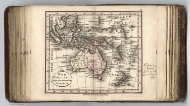
New Holland, with the adjacent Polynesia. Published by W. Faden. Jany. 1,1819. W. Palmer, Sc. (to accompany) Atlas minimus universalis, or, A geographical abridgement ancient and modern of the several parts of the earth ... Second edition. Jan 1, 1821.
List No
13243.065
Note
Double page outline hand color copperplate engraved map. Map 48 bound before map 47. Prime meridian is London. Relief shown pictorially. Includes manuscript log in right margin.
Author
Faden, William, 1749-1836
Full Title
Egypt - 1819. Published by Wm. Faden. Jany. 1,1819. T. Starling, Sculpt. (to accompany) Atlas minimus universalis, or, A geographical abridgement ancient and modern of the several parts of the earth ... Second edition. Jan 1, 1821.
List No
13243.066
Note
Double page outline hand color copperplate engraved map, with inset mao: Alexadnria. Prime meridian is Greenwich. Relief shown pictorially.
Author
Faden, William, 1749-1836
Full Title
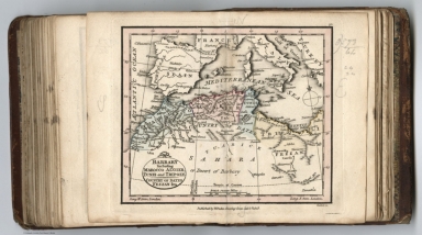
Barbary including Marocco, Algier, Tunis and Tripoly : Country of dates Fezzan &ca. Published by Wm. Faden. Jany. 1,1819. Hatchett, Sc. (to accompany) Atlas minimus universalis, or, A geographical abridgement ancient and modern of the several parts of the earth ... Second edition. Jan 1, 1821.
List No
13243.067
Note
Double page outline hand color copperplate engraved map, Prime meridian is London. Relief shown pictorially. Includes manuscript log in right margin.
Author
Faden, William, 1749-1836
Full Title
Nigritia and Guinea, with the African coast from Cape Blanco to Cape Lopo-Gonsalve. Published by Wm. Faden. Jany. 1,1819. Palmer, Sc. (to accompany) Atlas minimus universalis, or, A geographical abridgement ancient and modern of the several parts of the earth ... Second edition. Jan 1, 1821.
List No
13243.068
Note
Double page outline hand color copperplate engraved map, of western Africa, covers the west coast of Africa. Prime meridian is London. Relief shown pictorially.
Author
Faden, William, 1749-1836
Full Title
Colony of the Cape of Good Hope with the course of the Orange River. Published by Wm. Faden. Jany. 1,1819. D. Henwood, Sculp. (to accompany) Atlas minimus universalis, or, A geographical abridgement ancient and modern of the several parts of the earth ... Second edition. Jan 1, 1821.
List No
13243.069
Note
Double page outline hand color copperplate engraved map. Shows districts, settlements, rivers, etc. Prime meridian is Greenwich. Relief shown pictorially.
Author
Faden, William, 1749-1836
Full Title
British possessions in North America with the United States 1818. Published by Wm. Faden. Jany. 1st.,1819. W. Palmer, Sculp. (to accompany) Atlas minimus universalis, or, A geographical abridgement ancient and modern of the several parts of the earth ... Second edition. Jan 1, 1821.
List No
13243.071
Note
Double page outline hand color copperplate engraved map. Covers the area from the Gulf of St. Lawrence south to Florida and Louisiana. Shows political and administrative boundaries, cities and towns. Prime meridian is London. Relief shown pictorially.
Author
Faden, William, 1749-1836
Full Title
Mexico of Spanish Territories in North America. Published by Wm. Faden. Jany. 1st.,1819. T. Starling, Sculp. (to accompany) Atlas minimus universalis, or, A geographical abridgement ancient and modern of the several parts of the earth ... Second edition. Jan 1, 1821.
List No
13243.072
Note
Double page outline hand color copperplate engraved map, With inset: Continuation Southward. Prime meridian is Greenwich. Relief shown pictorially. Includes manuscript log in right margin.
Author
Faden, William, 1749-1836
Full Title
West India Islands. Published by Wm. Faden. Jany. 1st.,1819. W. Palmer, Sculp. (to accompany) Atlas minimus universalis, or, A geographical abridgement ancient and modern of the several parts of the earth ... Second edition. Jan 1, 1821.
List No
13243.073
Note
Double page outline hand color copperplate engraved map, Prime meridians are Ferro and London. Relief shown pictorially.
Author
Faden, William, 1749-1836
Full Title
South America from the latest Spanish and Portuguese surveys. Published by Wm. Faden. Jany. 1,1819. W. Palmer, Sculp. (to accompany) Atlas minimus universalis, or, A geographical abridgement ancient and modern of the several parts of the earth ... Second edition. Jan 1, 1821.
List No
13243.074
Note
Double page outline hand color copperplate engraved map,. Shows political divisions, major cities and towns. Prime meridians and Ferro and London. Relief shown pictorially.
Author
Faden, William, 1749-1836
Full Title
Nea-Polynesia or the Islands newly discover’d in the Pacific Ocean. Published by Wm. Faden. Jany. 1,1819. W. Palmer, Sculp. (to accompany) Atlas minimus universalis, or, A geographical abridgement ancient and modern of the several parts of the earth ... Second edition. Jan 1, 1821.
List No
13243.075
Note
Double page outline hand color copperplate engraved map. Shows expedition tracks of the Captain James Cook and Perouse in Pacific Ocean. Prime meridian is London. Relief shown pictorially.
Author
Faden, William, 1749-1836
Full Title
(Text Page to) Atlas minimus universalis, or, A geographical abridgement ancient and modern of the several parts of the earth : in fifty-eight maps composed principally for the use of schools, &c. Published by Wm. Faden, Geographer tp His Majesty. Second edition. Jan 1, 1821.
List No
13243.076
Note
Continues: Manuscript log by Wilson inscribing his voyages to and from India.
Author
Faden, William, 1749-1836
Full Title
(Text Page to) Atlas minimus universalis, or, A geographical abridgement ancient and modern of the several parts of the earth : in fifty-eight maps composed principally for the use of schools, &c. Published by Wm. Faden, Geographer tp His Majesty. Second edition. Jan 1, 1821.
List No
13243.077
Note
Continues: Manuscript log by Wilson inscribing his voyages to and from India.
Author
Faden, William, 1749-1836
Full Title
(Text Page to) Atlas minimus universalis, or, A geographical abridgement ancient and modern of the several parts of the earth : in fifty-eight maps composed principally for the use of schools, &c. Published by Wm. Faden, Geographer tp His Majesty. Second edition. Jan 1, 1821.
List No
13243.078
Note
Continues: Manuscript log by Wilson inscribing his voyages to and from India.
Author
Faden, William, 1749-1836
Full Title
(Text Page to) Atlas minimus universalis, or, A geographical abridgement ancient and modern of the several parts of the earth : in fifty-eight maps composed principally for the use of schools, &c. Published by Wm. Faden, Geographer tp His Majesty. Second edition. Jan 1, 1821.
List No
13243.079
Note
Continues: Manuscript log by Wilson inscribing his voyages to and from India.
Author
Faden, William, 1749-1836
Full Title
(Text Page to) Atlas minimus universalis, or, A geographical abridgement ancient and modern of the several parts of the earth : in fifty-eight maps composed principally for the use of schools, &c. Published by Wm. Faden, Geographer tp His Majesty. Second edition. Jan 1, 1821.
List No
13243.080
Note
Continues: Manuscript log by Wilson inscribing his voyages to and from India.
Author
Faden, William, 1749-1836
Full Title
(Text Page to) Atlas minimus universalis, or, A geographical abridgement ancient and modern of the several parts of the earth : in fifty-eight maps composed principally for the use of schools, &c. Published by Wm. Faden, Geographer tp His Majesty. Second edition. Jan 1, 1821.
List No
13243.081
Note
Continues: Manuscript log by Wilson inscribing his voyages to and from India.
Author
Spielmann and Brush
Full Title
Map of a farm situated at Harlem : belonging to the Estate of JNo. P. Waldron, Decd. New York April 26th. 1819. S. Ludlam, City Surveyor. Published by Spielmann & Brush, civil engineers, Hoboken, N.J. 1881. (to accompany) Certified copies of original maps of property in New York City.
List No
13338.107
Note
Hand colored cadastral map. Includes notes and compass rose oriented with the north to the left.
Author
Spielmann and Brush
Full Title
Map of the Estate of Morris Randel in the Twelfth (formerly Ninth) Ward in the City of New York. The original map was made by J. F. Bridges City Surveyor, October 25th. 1826. Published by Spielmann & Brush, civil engineers, Hoboken, N.J. 1881. (to accompany) Certified copies of original maps of property in New York City.
List No
13338.108
Note
Hand colored cadastral map. Includes notes and compass rose oriented with the north to the lower margin.
Author
Borghi, Bartolomeo, 1750-1821
Full Title
L'Ingria, e la Carelia Russa, dell'A. B. Borghi. Firenze 1817. A. Costa In.
List No
14255.025
Note
Engraved political map of the Ingria and Karelia portions of Russia, with hand-colored outlines delineating boundaries. Title translates to: [Ingria, and the Russian Karelia]. Shows political boundaries, topography, drainage, coastlines, islands and routes of travel. Relief shown pictorially. With latitudinal and longitudinal lines, as well as two bar scales. Imprint beneath title. Map is 30 x 22 cm, on sheet 47 x 35 cm. Descriptive text appears on prior plate (17).
Author
Borghi, Bartolomeo, 1750-1821
Full Title
Come fu e come Trovasi divisa al presente la Polonia, dell'A. B. Borghi. Firenze 1817.
List No
14255.026
Note
Engraved political map of Poland, with hand-colored outlines delineating boundaries. Title translates to: [Political boundaries of Poland, at the present time]. Shows political boundaries, topography, drainage, coastlines and routes of travel. Relief shown pictorially. With latitudinal and longitudinal lines. Imprint beneath title. Map is 22 x 30 cm, on sheet 35 x 47 cm.
Author
Borghi, Bartolomeo, 1750-1821
Full Title
(Text Page to) Prospetto Istorico-Politico-Civile-Naturale del Regno di Danimarca, compilato secondo il sistema dei moderni Geografi, e destinato per l'intelligenza della Danimarca, dell'A. B. Borghi. Firenze. Presso Niccolò Carli 1817.
List No
14255.027
Note
Descriptive text accompanying the subsequent map of Denmark on plate 26. Title translates to: [Historical-political-civil-natural prospectus of the Kingdom of Denmark ... ]. Imprint at bottom right.
Author
Borghi, Bartolomeo, 1750-1821
Full Title
Il Regno di Danimarca, dell'A. B. Borghi. Firenze 1817. Agp. Costa Inc.
List No
14255.028
Note
Engraved political map of Denmark, with hand-colored outlines delineating boundaries. Title translates to: [The Kingdom of Denmark]. Shows political boundaries, topography, drainage, coastlines, islands and routes of travel. Relief shown pictorially. With latitudinal and longitudinal lines, as well as two bar scales. Imprint beneath title. Map is 30 x 22 cm, on sheet 47 x 35 cm. Descriptive text appears on prior plate (25).
Author
Borghi, Bartolomeo, 1750-1821
Full Title
(Text Page to) Primo prospetto Istorico-Politico-Civile-Naturale dell'Impero Britannico, compilato secondo il sistema dei moderni Geografi, e destinato per l'intelligenza delle Carte dell'Inghilterra, dell'A. B. Borghi. Firenze. Presso Niccolò Carli 1817.
List No
14255.029
Note
Descriptive text accompanying the subsequent maps of the British Empire on plates 29-37. Title translates to: [First historical-political-civil-natural prospectus of the British Empire ... ]. First of two plates (27-28) of descriptive text on the British Empire. Imprint at bottom center.
Author
Borghi, Bartolomeo, 1750-1821
Full Title
(Text Page to) Secondo prospetto Istorico-Politico-Civile-Naturale dell'Impero Britannico, compilato secondo il sistema dei moderni Geografi, e destinato per l'intelligenza delle Carte dell'Inghilterra, dell'A. B. Borghi. Firenze. Presso Niccolò Carli 1817.
List No
14255.030
Note
Descriptive text accompanying the subsequent maps of the British Empire on plates 29-37. Title translates to: [First historical-political-civil-natural prospectus of the British Empire ... ]. Second of two plates (27-28) of descriptive text on the British Empire. Imprint at bottom right.
Author
Borghi, Bartolomeo, 1750-1821
Full Title
L'Isole Britanniche, dell'A. B. Borghi. Firenze 1816. Agp. Costa Inc.
List No
14255.031
Note
Engraved political map of the British Isles, with hand-colored outlines delineating boundaries. Title translates to: [The British Isles]. Shows political boundaries, topography, drainage, coastlines, islands and routes of travel. Relief shown pictorially. With latitudinal and longitudinal lines. Imprint beneath title. Map is 30 x 22 cm, on sheet 47 x 35 cm. Descriptive text appears on prior plates (27-28).
Author
Borghi, Bartolomeo, 1750-1821
Full Title
Parte Settentrionale della Scozia, dell'A. B. Borghi. Firenze 1816.
List No
14255.032
Note
Engraved political map of northern Scotland, with hand-colored outlines delineating boundaries. Title translates to: [Northern part of Scotland]. Shows political boundaries, topography, drainage, coastlines, islands and routes of travel. Relief shown pictorially. With latitudinal and longitudinal lines, as well as two bar scales. Imprint beneath title. Map is 22 x 30 cm, on sheet 35 x 47 cm. Descriptive text appears on prior plates (27-28).
Author
Borghi, Bartolomeo, 1750-1821
Full Title
La Scozia Meridionale, dell'A. B. Borghi. Firenze 1816.
List No
14255.033
Note
Engraved political map of southern Scotland, with hand-colored outlines delineating boundaries. Title translates to: [Southern Scotland]. Shows political boundaries, topography, drainage, coastlines, islands and routes of travel. Relief shown pictorially. With latitudinal and longitudinal lines, as well as two bar scales. Imprint beneath title. Map is 22 x 30 cm, on sheet 35 x 47 cm. Descriptive text appears on prior plates (27-28).
Author
Borghi, Bartolomeo, 1750-1821
Full Title
Parte Settentrionale dell'Inghilterra, dell'A. B. Borghi. Firenze 1816.
List No
14255.034
Note
Engraved political map of northern England, with hand-colored outlines delineating boundaries. Title translates to: [Northern part of England]. Shows political boundaries, topography, drainage, coastlines, islands and routes of travel. Relief shown pictorially. With latitudinal and longitudinal lines, as well as two bar scales. Imprint beneath title. Map is 22 x 30 cm, on sheet 35 x 47 cm. Descriptive text appears on prior plates (27-28).
Author
Borghi, Bartolomeo, 1750-1821
Full Title
Le provincie che sono all'Ovest dell'Inghilterra, dell'A. B. Borghi. Firenze 1816.
List No
14255.035
Note
Engraved political map of western England, with hand-colored outlines delineating boundaries. Title translates to: [The provinces which are in the west of England]. Shows political boundaries, topography, drainage, coastlines, islands and routes of travel. Relief shown pictorially. With latitudinal and longitudinal lines, as well as two bar scales. Imprint beneath title. Map is 22 x 30 cm, on sheet 35 x 47 cm. Descriptive text appears on prior plates (27-28).
Author
Borghi, Bartolomeo, 1750-1821
Full Title
Le provincie che formano la parte dell'Est dell'Inghilterra, dell'A. B. Borghi. Firenze 1818.
List No
14255.036
Note
Engraved political map of eastern England, with hand-colored outlines delineating boundaries. Title translates to: [The provinces that form the part of the east of England]. Shows political boundaries, topography, drainage, coastlines and routes of travel. Relief shown pictorially. With latitudinal and longitudinal lines, as well as two bar scales. Imprint beneath title. Map is 22 x 29 cm, on sheet 35 x 47 cm. Descriptive text appears on prior plates (27-28).
Author
Borghi, Bartolomeo, 1750-1821
Full Title
Le provincie che sono al Sud Est dell Inghilterra, dell'A. B. Borghi. Firenze 1816.
List No
14255.037
Note
Engraved political map of southeastern England, with hand-colored outlines delineating boundaries. Title translates to: [The provinces which are the southeast of England]. Shows political boundaries, topography, drainage, coastlines, islands and routes of travel. Relief shown pictorially. With latitudinal and longitudinal lines, as well as two bar scales. Imprint beneath title. Map is 22 x 30 cm, on sheet 35 x 47 cm. Descriptive text appears on prior plates (27-28).
Author
Borghi, Bartolomeo, 1750-1821
Full Title
Le provincie che sono al Sud Ovest dell'Inghilterra, dell'A. B. Borghi. Firenze 1816.
List No
14255.038
Note
Engraved political map of southwestern England, including the English Channel, with hand-colored outlines delineating boundaries. Title translates to: [The provinces which are the southwest of England]. Shows political boundaries, topography, drainage, coastlines and routes of travel. Relief shown pictorially. With latitudinal and longitudinal lines, as well as two bar scales. Imprint beneath title. Map is 22 x 30 cm, on sheet 35 x 47 cm. Descriptive text appears on prior plates (27-28).
Author
Borghi, Bartolomeo, 1750-1821
Full Title
L'Irlanda, dell'A. B. Borghi. Firenze 1816.
List No
14255.039
Note
Engraved political map of Ireland, with hand-colored outlines delineating boundaries. Title translates to: [Ireland]. Shows political boundaries, topography, drainage, coastlines, islands and routes of travel. Relief shown pictorially. With latitudinal and longitudinal lines, as well as two bar scales. Imprint beneath title. Map is 30 x 22 cm, on sheet 47 x 35 cm. Descriptive text appears on prior plates (27-28).
Author
Borghi, Bartolomeo, 1750-1821
Full Title
Il Regno Belgico ovvero de Paesi Bassi, dell'A. B. Borghi. Firenze 1818. Ago Costa Inc.
List No
14255.040
Note
Engraved political map of Belgium and the Netherlands, with hand-colored outlines delineating boundaries. Title translates to: [The Belgian Kingdom, or the Netherlands]. Shows political boundaries, topography, drainage, coastlines, islands and routes of travel. Relief shown pictorially. With latitudinal and longitudinal lines, as well as three bar scales. Imprint beneath title. Map is 30 x 22 cm, on sheet 47 x 35 cm.
Author
Borghi, Bartolomeo, 1750-1821
Full Title
La sette provincie unite ora parte Settentrionale del Regno Belgico, dell'A. B. Borghi. Firenze 1817.
List No
14255.041
Note
Engraved political map of Belgium, with hand-colored outlines delineating boundaries. Title translates to: [The seven united provinces, now Northern part of the Belgian Kingdom]. Shows political boundaries, topography, drainage, coastlines, islands and routes of travel. Relief shown pictorially. With latitudinal and longitudinal lines, as well as two bar scales. Imprint beneath title. Map is 30 x 22 cm, on sheet 47 x 35 cm.
Author
Borghi, Bartolomeo, 1750-1821
Full Title
Paesi Bassi Austriaci ora parte Meridionale del Regno Belgico, dell'A. B. Borghi. Firenze 1817.
List No
14255.042
Note
Engraved political map of southern Belgium, with hand-colored outlines delineating boundaries. Title translates to: [Austrian Netherlands, now Southern part of the Belgian Kingdom]. Shows political boundaries, topography, drainage, coastlines and routes of travel. Relief shown pictorially. With latitudinal and longitudinal lines, as well as two bar scales. Imprint beneath title. Map is 22 x 30 cm, on sheet 35 x 47 cm.
Author
Borghi, Bartolomeo, 1750-1821
Full Title
La Germania divisa ne suoi circoli, dell'A. B. Borghi. Firenze 1817.
List No
14255.043
Note
Engraved political map of Germany, with hand-colored outlines delineating boundaries. Title translates to: [Germany, divided in its circles]. Shows political boundaries, topography, drainage, coastlines and islands. Relief shown pictorially. With latitudinal and longitudinal lines. Imprint beneath title. Map is 22 x 30 cm, on sheet 35 x 47 cm.
Author
Borghi, Bartolomeo, 1750-1821
Full Title
Circolo della Bassa Sassonia come era nel 1790, dell'A. B. Borghi. Firenze 1817.
List No
14255.044
Note
Engraved historical and political map of Lower Saxony, with hand-colored outlines delineating boundaries in 1790. Title translates to: [Circle of Lower Saxony, as it was in 1790]. Shows political boundaries, topography, drainage, coastlines and islands. Relief shown pictorially. With latitudinal and longitudinal lines, as well as two bar scales. Imprint beneath title. Map is 22 x 30 cm, on sheet 35 x 47 cm.
Author
Borghi, Bartolomeo, 1750-1821
Full Title
Parte Settentrionale del circolo dell'Alta Sassonia come era nel 1790, dell'A. B. Borghi. Firenze 1817.
List No
14255.045
Note
Engraved historical and political map of Upper Saxony, with hand-colored outlines delineating boundaries in 1790. Title translates to: [Northern part of the circle of Upper Saxony, as it was in 1790]. Shows political boundaries, topography, drainage, coastlines and routes of travel. Relief shown pictorially. With latitudinal and longitudinal lines, as well as two bar scales. Imprint beneath title. Map is 22 x 30 cm, on sheet 35 x 47 cm.
Author
Borghi, Bartolomeo, 1750-1821
Full Title
Parte Meridionale del circolo dell'Alta Sassonia col Margrto. di Lusazia etc. come era nel 1790, dell'A. B. Borghi. Firenze 1817.
List No
14255.046
Note
Engraved historical and political map of Upper Saxony, with hand-colored outlines delineating boundaries in 1790. Title translates to: [Southern part of the circle of Upper Saxony with Margrto. of Lusazia etc., as it was in 1790]. Shows political boundaries, topography, drainage and routes of travel. Relief shown pictorially. With latitudinal and longitudinal lines, as well as two bar scales. Imprint beneath title. Indexed to indicate points of interest, such as Gotha. Map is 22 x 30 cm, on sheet 35 x 47 cm.
Author
Borghi, Bartolomeo, 1750-1821
Full Title
Circolo di Westfalia come era nel 1790, dell'A. B. Borghi. Firenze 1817.
List No
14255.047
Note
Engraved historical and political map of Westphalia, with hand-colored outlines delineating boundaries in 1790. Title translates to: [Circle of Westphalia, as it was in 1790]. Shows political boundaries, topography, drainage and routes of travel. Relief shown pictorially. With latitudinal and longitudinal lines, as well as two bar scales. Imprint beneath title. Indexed to indicate points of interest, such as Schavemburg d'Hassia Cassel. Map is 30 x 22 cm, on sheet 47 x 35 cm.
Author
Borghi, Bartolomeo, 1750-1821
Full Title
Il circolo dell'Alto Reno come era nel 1790, dell'A. B. Borghi. Firenze 1817.
List No
14255.048
Note
Engraved historical and political map of Upper Rhine, with hand-colored outlines delineating boundaries in 1790. Title translates to: [The circle of the Upper Rhine, as it was in 1790]. Shows political boundaries, topography, drainage and routes of travel. Relief shown pictorially. With latitudinal and longitudinal lines, as well as two bar scales. Imprint beneath title. Indexed to indicate points of interest, such as Magonza. Map is 30 x 22 cm, on sheet 47 x 35 cm.
Author
Borghi, Bartolomeo, 1750-1821
Full Title
Circolo del Basso Reno come era nel 1790, dell'A. B. Borghi. Firenze 1817. A Costa Inc.
List No
14255.049
Note
Engraved historical and political map of Lower Rhine, with hand-colored outlines delineating boundaries in 1790. Title translates to: [The circle of the Lower Rhine, as it was in 1790]. Shows political boundaries, topography, drainage and routes of travel. Relief shown pictorially. With latitudinal and longitudinal lines, as well as two bar scales. Imprint beneath title. Map is 30 x 22 cm, on sheet 47 x 35 cm.
Author
Borghi, Bartolomeo, 1750-1821
Full Title
Il circolo di Franconia come era nel 1790, dell'A. B. Borghi. Firenze 1817.
List No
14255.050
Note
Engraved historical and political map of Franconia, with hand-colored outlines delineating boundaries in 1790. Title translates to: [The circle of Franconia, as it was in 1790]. Shows political boundaries, topography, drainage and routes of travel. Relief shown pictorially. With latitudinal and longitudinal lines, as well as two bar scales. Imprint beneath title. Indexed to indicate points of interest, such as Città Imperiali. Map is 22 x 30 cm, on sheet 35 x 47 cm.
Author
Borghi, Bartolomeo, 1750-1821
Full Title
Il circolo di Svevia come era nel 1790, dell'A. B. Borghi. Firenze 1817.
List No
14255.051
Note
Engraved historical and political map of Swabia, with hand-colored outlines delineating boundaries in 1790. Title translates to: [The circle of Swabia, as it was in 1790]. Shows political boundaries, topography, drainage, shorelines and routes of travel. Relief shown pictorially. With latitudinal and longitudinal lines, as well as two bar scales. Imprint beneath title. Map is 22 x 29 cm, on sheet 35 x 47 cm.
Author
Borghi, Bartolomeo, 1750-1821
Full Title
Circolo di Baviera come era nel 1790, dell'A. B. Borghi. Firenze 1817.
List No
14255.052
Note
Engraved historical and political map of Bavaria, with hand-colored outlines delineating boundaries in 1790. Title translates to: [The circle of Bavaria, as it was in 1790]. Shows political boundaries, topography, drainage, shorelines and routes of travel. Relief shown pictorially. With latitudinal and longitudinal lines, as well as two bar scales. Imprint beneath title. Map is 30 x 22 cm, on sheet 47 x 35 cm.
Author
Borghi, Bartolomeo, 1750-1821
Full Title
Il Regno di Boemia come era nel 1790, dell'A. B. Borghi. Firenze 1817.
List No
14255.053
Note
Engraved historical and political map of Bohemia, with hand-colored outlines delineating boundaries in 1790. Title translates to: [The Kingdom of Bohemia, as it was in 1790]. Shows political boundaries, topography, drainage and routes of travel. Relief shown pictorially. With latitudinal and longitudinal lines, as well as two bar scales. Imprint beneath title. Map is 30 x 22 cm, on sheet 47 x 35 cm.
Author
Borghi, Bartolomeo, 1750-1821
Full Title
La Moravia e la Slesia Austriaca, dell'A. B. Borghi. Firenze 1817.
List No
14255.054
Note
Engraved political map of Moravia (Czech Republic) and Silesia (Austria), with hand-colored outlines delineating boundaries. Title translates to: [Moravia and Austrian Silesia]. Shows political boundaries, topography, drainage and routes of travel. Relief shown pictorially. With latitudinal and longitudinal lines, as well as two bar scales. Imprint beneath title. Map is 22 x 30 cm, on sheet 35 x 47 cm.
Author
Borghi, Bartolomeo, 1750-1821
Full Title
La Slesia Prussiana come era nel 1790, dell'A. B. Borghi. Firenze 1817. A Costa S.
List No
14255.055
Note
Engraved historical and political map of Silesia (Prussia), with hand-colored outlines delineating boundaries in 1790. Title translates to: [Prussian Silesia, as it was in 1790]. Shows political boundaries, topography, drainage and routes of travel. Relief shown pictorially. With latitudinal and longitudinal lines, as well as two bar scales. Imprint beneath title. Map is 22 x 30 cm, on sheet 35 x 47 cm.
Author
Borghi, Bartolomeo, 1750-1821
Full Title
(Text Page to) Primo prospetto Istorico-Politico-Civile-Naturale dell'Impero Austria, e della Confederazione Germanica per l'intelligenza delle Carte dell'Atlante, dell'A. B. Borghi. Firenze, 1818, Presso Giovanni Marenigh.
List No
14255.056
Note
Descriptive text accompanying the subsequent maps of the Austrian Empire and German Confederation on plates 56-62. Title translates to: [First historical-political-civil-natural prospectus of the Austrian Empire, and of the German Confederation ... ]. Includes a table with political divisions. First of two plates (54-55) of descriptive text on the Austrian Empire and German Confederation. Imprint at bottom right.
Author
Borghi, Bartolomeo, 1750-1821
Full Title
(Text Page to) Secondo prospetto Istorico-Politico-Civile-Naturale dell'Impero Austria, e della Confederazione Germanica per l'intelligenza delle Carte dell'Atlante, dell'A. B. Borghi. Firenze, 1818, Presso Giovanni Marenigh.
List No
14255.057
Note
Descriptive text accompanying the subsequent maps of the Austrian Empire and German Confederation on plates 56-62. Title translates to: [First historical-political-civil-natural prospectus of the Austrian Empire, and of the German Confederation ... ]. Includes a table with political divisions. Second of two plates (54-55) of descriptive text on the Austrian Empire and German Confederation. Imprint at bottom right.
Author
Borghi, Bartolomeo, 1750-1821
Full Title
La Germania come trovasi divisa in oggi, dell'A. B. Borghi. Firenze 1819, incisa nello Studio Giarre.
List No
14255.058
Note
Engraved political map of Germany, with hand-colored outlines delineating boundaries. Title translates to: [Germany, as it is divided into today]. Shows political boundaries, topography, drainage and routes of travel. Relief shown pictorially. With latitudinal and longitudinal lines. Imprint beneath title. Indexed to indicate areas, such as Ducato di Saxe Gota. Map is 22 x 29 cm, on sheet 35 x 47 cm. Descriptive text appears on prior plates (54-55).
Author
Borghi, Bartolomeo, 1750-1821
Full Title
L'Alta Germania compresovi l'Impero d'Austria fogli sei, dell'A. B. Borghi. Firenze 1819 (1).
List No
14255.059
Note
Engraved political map of northern Germany, as well as Austria (including Austrian Dalmatia), with hand-colored outlines delineating boundaries. Title translates to: [Upper Germany, including the Empire of Austria, six folios]. Shows political boundaries, topography, drainage, coastlines and routes of travel. Relief shown pictorially. With latitudinal and longitudinal lines, as well as two bar scales. Also, with inset: Supplimento per l'Impero d'Austria la Dalmazia [= Supplement for the Empire of Austria, Dalmatia]. First (southwest) in a series of six sheets that together comprise the full map (plates 57-62). (Title and imprint taken from fifth sheet.) Sheet is 21 x 29 cm, on sheet 35 x 47 cm. Descriptive text appears on prior plates (54-55).
Author
Borghi, Bartolomeo, 1750-1821
Full Title
L'Alta Germania compresovi l'Impero d'Austria fogli sei, dell'A. B. Borghi. Firenze 1819 (2).
List No
14255.060
Note
Engraved political map of northern Germany, as well as Austria (including Austrian Dalmatia), with hand-colored outlines delineating boundaries. Title translates to: [Upper Germany, including the Empire of Austria, six folios]. Shows political boundaries, topography, drainage and routes of travel. Relief shown pictorially. With latitudinal and longitudinal lines. Additionally, includes two bar scales on first sheet. Second (south-central) in a series of six sheets that together comprise the full map (plates 57-62). Also, with inset on first sheet: Supplimento per l'Impero d'Austria la Dalmazia [= Supplement for the Empire of Austria, Dalmatia]. (Title and imprint taken from fifth sheet.) Sheet is 21 x 30 cm, on sheet 35 x 47 cm. Descriptive text appears on prior plates (54-55).
Author
Borghi, Bartolomeo, 1750-1821
Full Title
L'Alta Germania compresovi l'Impero d'Austria fogli sei, dell'A. B. Borghi. Firenze 1819 (3).
List No
14255.061
Note
Engraved political map of northern Germany, as well as Austria (including Austrian Dalmatia), with hand-colored outlines delineating boundaries. Title translates to: [Upper Germany, including the Empire of Austria, six folios]. Shows political boundaries, topography, drainage and routes of travel. Relief shown pictorially. With latitudinal and longitudinal lines. Additionally, includes two bar scales on first sheet. Third (southeast) in a series of six sheets that together comprise the full map (plates 57-62). Also, with inset on first sheet: Supplimento per l'Impero d'Austria la Dalmazia [= Supplement for the Empire of Austria, Dalmatia]. (Title and imprint taken from fifth sheet.) Sheet is 21 x 30 cm, on sheet 35 x 47 cm. Descriptive text appears on prior plates (54-55).
Author
Borghi, Bartolomeo, 1750-1821
Full Title
L'Alta Germania compresovi l'Impero d'Austria fogli sei, dell'A. B. Borghi. Firenze 1819 (4).
List No
14255.062
Note
Engraved political map of northern Germany, as well as Austria (including Austrian Dalmatia), with hand-colored outlines delineating boundaries. Title translates to: [Upper Germany, including the Empire of Austria, six folios]. Shows political boundaries, topography, drainage and routes of travel. Relief shown pictorially. With latitudinal and longitudinal lines. Additionally, includes two bar scales on first sheet. Fourth (northeast) in a series of six sheets that together comprise the full map (plates 57-62). Also, with inset on first sheet: Supplimento per l'Impero d'Austria la Dalmazia [= Supplement for the Empire of Austria, Dalmatia]. (Title and imprint taken from fifth sheet.) Sheet is 21 x 30 cm, on sheet 35 x 47 cm. Descriptive text appears on prior plates (54-55).
Author
Borghi, Bartolomeo, 1750-1821
Full Title
L'Alta Germania compresovi l'Impero d'Austria fogli sei, dell'A. B. Borghi. Firenze 1819 (5).
List No
14255.063
Note
Engraved political map of northern Germany, as well as Austria (including Austrian Dalmatia), with hand-colored outlines delineating boundaries. Title translates to: [Upper Germany, including the Empire of Austria, six folios]. Shows political boundaries, topography, drainage and routes of travel. Relief shown pictorially. With latitudinal and longitudinal lines. Additionally, includes two bar scales on first sheet. Imprint beneath title. Fifth (north-central) in a series of six sheets that together comprise the full map (plates 57-62). Also, with inset on first sheet: Supplimento per l'Impero d'Austria la Dalmazia [= Supplement for the Empire of Austria, Dalmatia]. Sheet is 21 x 30 cm, on sheet 35 x 47 cm. Descriptive text appears on prior plates (54-55).
Author
Borghi, Bartolomeo, 1750-1821
Full Title
L'Alta Germania compresovi l'Impero d'Austria fogli sei, dell'A. B. Borghi. Firenze 1819 (6).
List No
14255.064
Note
Engraved political map of northern Germany, as well as Austria (including Austrian Dalmatia), with hand-colored outlines delineating boundaries. Title translates to: [Upper Germany, including the Empire of Austria, six folios]. Shows political boundaries, topography, drainage and routes of travel. Relief shown pictorially. With latitudinal and longitudinal lines. Additionally, includes two bar scales on first sheet. Sixth (northwest) in a series of six sheets that together comprise the full map (plates 57-62). Also, with inset on first sheet: Supplimento per l'Impero d'Austria la Dalmazia [= Supplement for the Empire of Austria, Dalmatia]. (Title and imprint taken from fifth sheet.) Sheet is 21 x 29 cm, on sheet 35 x 47 cm. Descriptive text appears on prior plates (54-55).
Author
Borghi, Bartolomeo, 1750-1821
Full Title
(Composite Map to) L'Alta Germania compresovi l'Impero d'Austria fogli sei, dell'A. B. Borghi. Firenze 1819.
List No
14255.065
Note
Composite map to L'Alta Germania compresovi l'Impero d'Austria fogli sei, Engraved political map of northern Germany, as well as Austria (including Austrian Dalmatia), with hand-colored outlines delineating boundaries. Title translates to: [Upper Germany, including the Empire of Austria, six folios]. Shows political boundaries, topography, drainage, coastlines, islands and routes of travel. Relief shown pictorially. With latitudinal and longitudinal lines, as well as two bar scales and a descriptive note. Imprint beneath title. Map comprised of six sheets on plates 57-62. Also, with inset: Supplimento per l'Impero d'Austria la Dalmazia [= Supplement for the Empire of Austria, Dalmatia]. Together, sheets are 42 x 89 cm, on sheets 70 x 141 cm. Descriptive text appears on prior plates (54-55).
Author
Borghi, Bartolomeo, 1750-1821
Full Title
(Text Page to) Prospetto Istorico-Politico-Civile-Naturale del regno di Prussia, destinato per l'intelligenza delle Carte dell'Atlante, dell'A. B. Borghi. Firenze, 1818, Presso Giovanni Marenigh.
List No
14255.066
Note
Descriptive text accompanying the subsequent maps of the Austrian Empire and German Confederation on plates 64-67. Title translates to: [First historical-political-civil-natural prospectus of the Kingdom of Prussia ... ]. Includes a table with political divisions. Imprint at bottom right.
Author
Borghi, Bartolomeo, 1750-1821
Full Title
La Bassa Germania con tutti i cambiamenti fatti ivi fino al presente, dell'A. Bartolommeo Borghi. Firenze 1818 (1).
List No
14255.067
Note
Engraved political map of southern Germany, with hand-colored outlines delineating boundaries. Title translates to: [Lower Germany ..]. Shows political boundaries, topography, drainage and routes of travel. Relief shown pictorially. With latitudinal and longitudinal lines, as well as two bar scales. Imprint beneath title. First (southeast) in a series of four sheets that together comprise the full map (plates 64-67). Sheet is 22 x 30 cm, on sheet 35 x 47 cm. Descriptive text appears on prior plate (63).
Author
Borghi, Bartolomeo, 1750-1821
Full Title
La Bassa Germania con tutti i cambiamenti fatti ivi fino al presente, dell'A. Bartolommeo Borghi. Firenze 1818 (2).
List No
14255.068
Note
Engraved political map of southern Germany, with hand-colored outlines delineating boundaries. Title translates to: [Lower Germany ..]. Shows political boundaries, topography, drainage and routes of travel. Relief shown pictorially. With latitudinal and longitudinal lines. Additionally, includes two bar scales on first sheet. Second (southwest) in a series of four sheets that together comprise the full map (plates 64-67). (Title and imprint taken from first sheet.) Sheet is 22 x 30 cm, on sheet 35 x 47 cm. Descriptive text appears on prior plate (63).
Author
Borghi, Bartolomeo, 1750-1821
Full Title
La Bassa Germania con tutti i cambiamenti fatti ivi fino al presente, dell'A. Bartolommeo Borghi. Firenze 1818 (3).
List No
14255.069
Note
Engraved political map of southern Germany, with hand-colored outlines delineating boundaries. Title translates to: [Lower Germany ..]. Shows political boundaries, topography, drainage, coastlines and routes of travel. Relief shown pictorially. With latitudinal and longitudinal lines. Additionally, includes two bar scales on first sheet. Third (northeast) in a series of four sheets that together comprise the full map (plates 64-67). (Title and imprint taken from first sheet.) Sheet is 22 x 30 cm, on sheet 35 x 47 cm. Descriptive text appears on prior plate (63).
Author
Borghi, Bartolomeo, 1750-1821
Full Title
La Bassa Germania con tutti i cambiamenti fatti ivi fino al presente, dell'A. Bartolommeo Borghi. Firenze 1818 (4).
List No
14255.070
Note
Engraved political map of southern Germany, with hand-colored outlines delineating boundaries. Title translates to: [Lower Germany ..]. Shows political boundaries, topography, drainage, coastlines and routes of travel. Relief shown pictorially. With latitudinal and longitudinal lines. Additionally, includes two bar scales on first sheet. Fourth (northwest) in a series of four sheets that together comprise the full map (plates 64-67). (Title and imprint taken from first sheet.) Sheet is 22 x 30 cm, on sheet 35 x 47 cm. Descriptive text appears on prior plate (63).
Author
Borghi, Bartolomeo, 1750-1821
Full Title
(Composite Map to) L'Alta Germania compresovi l'Impero d'Austria fogli sei, dell'A. B. Borghi. Firenze 1819.
List No
14255.071
Note
Composite map to La Bassa Germania con tutti i cambiamenti fatti ivi fino al presente, Engraved political map of southern Germany, with hand-colored outlines delineating boundaries. Title translates to: [Lower Germany ..]. Shows political boundaries, topography, drainage, coastlines, islands and routes of travel. Relief shown pictorially. With latitudinal and longitudinal lines, as well as two bar scales and a descriptive note. Imprint beneath title. Map comprised of four sheets on plates 64-67. Together, sheets are 44 x 60 cm, on sheets 70 x 94 cm. Descriptive text appears on prior plate (63).
Author
Borghi, Bartolomeo, 1750-1821
Full Title
(Text Page to) Primo prospetto Istorico-Politico-Civile-Naturale del Regno di Francia, compilato secondo il sistema dei moderni Geografi, e destinato per l'intelligenza delle Carte dell'Francia, dell'A. B. Borghi. Firenze. Presso Niccolò Carli 1817.
List No
14255.072
Note
Descriptive text accompanying the subsequent maps of the Kingdom of France on plates 70-85. Title translates to: [First historical-political-civil-natural prospectus of the Kingdom of France ... ]. Includes a table with political divisions. First of two plates (68-69) of descriptive text on the Kingdom of France. Imprint at bottom right.
Author
Borghi, Bartolomeo, 1750-1821
Full Title
(Text Page to) Secondo prospetto Istorico-Politico-Civile-Naturale del Regno di Francia, compilato secondo il sistema dei moderni Geografi, e destinato per l'intelligenza delle Carte dell'Francia, dell'A. B. Borghi. Firenze. Presso Niccolò Carli 1817.
List No
14255.073
Note
Descriptive text accompanying the subsequent maps of the Kingdom of France on plates 70-85. Title translates to: [First historical-political-civil-natural prospectus of the Kingdom of France ... ]. Second of two plates (68-69) of descriptive text on the Kingdom of France. Imprint at bottom right.
Author
Borghi, Bartolomeo, 1750-1821
Full Title
La Francia divisa in governi come era prima del 1789, dell'A. B. Borghi. Firenze 1817.
List No
14255.074
Note
Engraved historical and political map of France, with hand-colored outlines delineating boundaries in 1789. Title translates to: [France, divided into governments, as it was before 1789]. Shows political boundaries, topography, drainage, coastlines, islands and routes of travel. Relief shown pictorially. With latitudinal and longitudinal lines. Imprint beneath title. Map is 22 x 30 cm, on sheet 35 x 47 cm. Descriptive text appears on prior plates (68-69).
Author
Borghi, Bartolomeo, 1750-1821
Full Title
La Francia divisa in dipartimenti, dell'A. B. Borghi. Firenze 1816.
List No
14255.075
Note
Engraved political map of France, with hand-colored outlines delineating boundaries. Title translates to: [France, divided into departments]. Shows political boundaries, topography, drainage, coastlines, islands and routes of travel. Relief shown pictorially. With latitudinal and longitudinal lines, as well as a legend and a descriptive note. Imprint beneath title. Map is 22 x 30 cm, on sheet 35 x 47 cm. Descriptive text appears on prior plates (68-69).
Author
Borghi, Bartolomeo, 1750-1821
Full Title
La Normandia col Maine e Perche ridotti a dipartimenti, dell'A. B. Borghi. Firenze 1817.
List No
14255.076
Note
Engraved political map of Normandy (France), with hand-colored outlines delineating boundaries. Title translates to: [Normandy with Maine and Perche, divided into departments]. Shows political boundaries, topography, drainage, coastlines and routes of travel. Relief shown pictorially. With latitudinal and longitudinal lines, as well as two bar scales. Imprint beneath title. Map is 30 x 23 cm, on sheet 47 x 35 cm. Descriptive text appears on prior plates (68-69).
Author
Borghi, Bartolomeo, 1750-1821
Full Title
I governi de Paesi Bassi Francesi dell'Artesia della Piccardia e dell'Isola di Francia ridotti a dipartimenti, dell'A. B. Borghi. Firenze 1817.
List No
14255.077
Note
Engraved political map of the historical region of Picardy (France) and the Isle of France, with hand-colored outlines delineating boundaries. Title translates to: [The governments of the French Netherlands of Artesia of Picardy and of the Isle of France, divided into departments]. Shows political boundaries, topography, drainage, coastlines and routes of travel. Relief shown pictorially. With latitudinal and longitudinal lines, as well as two bar scales. Imprint beneath title. Map is 30 x 23 cm, on sheet 47 x 35 cm. Descriptive text appears on prior plates (68-69).
Author
Borghi, Bartolomeo, 1750-1821
Full Title
La Sciampagna ridotti a dipartimenti, dell'A. B. Borghi. Firenze 1817.
List No
14255.078
Note
Engraved political map of Champagne (France), with hand-colored outlines delineating boundaries. Title translates to: [Champagne, divided into departments]. Shows political boundaries, topography, drainage, coastlines and routes of travel. Relief shown pictorially. With latitudinal and longitudinal lines, as well as two bar scales. Imprint beneath title. Map is 30 x 22 cm, on sheet 47 x 35 cm. Descriptive text appears on prior plates (68-69).
Author
Borghi, Bartolomeo, 1750-1821
Full Title
La Lorena e l'Alsazia ridotti a dipartimenti, dell'A. B. Borghi. Firenze 1817.
List No
14255.079
Note
Engraved political map of the historical regions of Lorraine and Alsace in France, with hand-colored outlines delineating boundaries. Title translates to: [Lorraine and Alsace, divided into departments]. Shows political boundaries, topography, drainage, coastlines and routes of travel. Relief shown pictorially. With latitudinal and longitudinal lines, as well as two bar scales. Imprint beneath title. Map is 22 x 30 cm, on sheet 35 x 47 cm. Descriptive text appears on prior plates (68-69).
Author
Borghi, Bartolomeo, 1750-1821
Full Title
La Bretagna ridotti a dipartimenti, dell'A. B. Borghi. Firenze 1817.
List No
14255.080
Note
Engraved political map of Brittany (France), with hand-colored outlines delineating boundaries. Title translates to: [Brittany, divided into departments]. Shows political boundaries, topography, drainage, coastlines, islands and routes of travel. Relief shown pictorially. With latitudinal and longitudinal lines, as well as two bar scales. Imprint beneath title. Map is 22 x 30 cm, on sheet 35 x 47 cm. Descriptive text appears on prior plates (68-69).
Author
Borghi, Bartolomeo, 1750-1821
Full Title
L'Anjou il Saumurois il Poitou l'Aunis la Saintonge e l'Angoumois ridotti a dipartimenti, dell'A. B. Borghi. Firenze 1817.
List No
14255.081
Note
Engraved political map of the historical regions of Anjou, Saumurois, Poitou, Aunis, Saintonge and Angoumois in France, with hand-colored outlines delineating boundaries. Title translates to: [The Anjou, the Saumurois, the Poitou, the Aunis, the Saintonge and the Angoumois, divided into departments]. Shows political boundaries, topography, drainage, coastlines, islands and routes of travel. Relief shown pictorially. With latitudinal and longitudinal lines, as well as two bar scales. Imprint beneath title. Map is 30 x 22 cm, on sheet 47 x 35 cm. Descriptive text appears on prior plates (68-69).
Author
Borghi, Bartolomeo, 1750-1821
Full Title
L'Orleanese la Turrena e Nivernese ridotti a dipartimenti, dell'A. B. Borghi. Firenze 1817.
List No
14255.082
Note
Engraved political map of the historical regions of Orléans, Touraine and Nivernais in France, with hand-colored outlines delineating boundaries. Title translates to: [The Anjou, the Touraine and Nivernais, divided into departments]. Shows political boundaries, topography, drainage and routes of travel. Relief shown pictorially. With latitudinal and longitudinal lines, as well as two bar scales. Imprint beneath title. Map is 22 x 30 cm, on sheet 35 x 47 cm. Descriptive text appears on prior plates (68-69).
Author
Borghi, Bartolomeo, 1750-1821
Full Title
Il Berri la Marche il Bourbonnois ed il Limosin ridotti a dipartimenti, dell'A. B. Borghi. Firenze 1817.
List No
14255.083
Note
Engraved political map of the historical regions of Berry, La Marche, Bourbonnais and Limousin in France, with hand-colored outlines delineating boundaries. Title translates to: [The Anjou, the Touraine and Nivernais, divided into departments]. Shows political boundaries, topography, drainage and routes of travel. Relief shown pictorially. With latitudinal and longitudinal lines, as well as two bar scales. Imprint beneath title. Map is 30 x 22 cm, on sheet 47 x 35 cm. Descriptive text appears on prior plates (68-69).
Author
Borghi, Bartolomeo, 1750-1821
Full Title
L'Auvergne en la parte Orientale della Linguadoca ridotti a dipartimenti, dell'A. B. Borghi. Firenze 1817.
List No
14255.084
Note
Engraved political map of the historical regions of Auvergne and Languedoc (eastern part), in France, with hand-colored outlines delineating boundaries. Title translates to: [The Auvergne and the eastern part of Languedoc, divided into departments]. Shows political boundaries, topography, drainage, coastlines and routes of travel. Relief shown pictorially. With latitudinal and longitudinal lines, as well as two bar scales. Imprint beneath title. Map is 30 x 22 cm, on sheet 47 x 35 cm. Descriptive text appears on prior plates (68-69).
Author
Borghi, Bartolomeo, 1750-1821
Full Title
La Borgogna Franca Contea e Lionese ridotti a dipartimenti, dell'A. B. Borghi. Firenze 1817.
List No
14255.085
Note
Engraved political map of the historical regions of Burgundy, Franche-Comté and Lyonnais in France, with hand-colored outlines delineating boundaries. Title translates to: [Burgundy Franche-Comté and Lyonnais, divided into departments]. Shows political boundaries, topography, drainage, coastlines and routes of travel. Relief shown pictorially. With latitudinal and longitudinal lines, as well as two bar scales. Imprint beneath title. Map is 30 x 22 cm, on sheet 47 x 35 cm. Descriptive text appears on prior plates (68-69).
Author
Borghi, Bartolomeo, 1750-1821
Full Title
I governi di Guascogna e di Guienna divisi a dipartimenti, dell'A. B. Borghi. Firenze 1817.
List No
14255.086
Note
Engraved political map of the historical regions of Gascony (France) and French Guinea, with hand-colored outlines delineating boundaries. Title translates to: [The governments of Gascogne and Guienna, divided into departments]. Shows political boundaries, topography, drainage, coastlines and routes of travel. Relief shown pictorially. With latitudinal and longitudinal lines, as well as two bar scales. Imprint beneath title. Map is 30 x 22 cm, on sheet 47 x 35 cm. Descriptive text appears on prior plates (68-69).
Author
Borghi, Bartolomeo, 1750-1821
Full Title
Il Quercy il Rouergue la Linguadoca Occidentale la Contea di Foix ed il Rossiglione divisi a dipartimenti, dell'A. B. Borghi. Firenze 1817.
List No
14255.087
Note
Engraved political map of the historical regions of Quercy, Rouergue, Languedoc (western part), Foix, and Roussillon in France, with hand-colored outlines delineating boundaries. Title translates to: [The Quercy, the Rouergue the Western Languedoc the County of Foix and the Roussillon, divided into departments]. Shows political boundaries, topography, drainage, coastlines and routes of travel. Relief shown pictorially. With latitudinal and longitudinal lines, as well as two bar scales. Imprint beneath title. Map is 30 x 22 cm, on sheet 47 x 35 cm. Descriptive text appears on prior plates (68-69).
Author
Borghi, Bartolomeo, 1750-1821
Full Title
La Provenza ed il Delfinato ridotti a dipartimenti, dell'A. B. Borghi. Firenze 1817.
List No
14255.088
Note
Engraved political map of the historical regions of Provence and Dauphiné in France, with hand-colored outlines delineating boundaries. Title translates to: [Provence and Dauphiné, divided into departments]. Shows political boundaries, topography, drainage, coastlines and routes of travel. Relief shown pictorially. With latitudinal and longitudinal lines, as well as two bar scales. Imprint beneath title. Map is 30 x 22 cm, on sheet 47 x 35 cm. Descriptive text appears on prior plates (68-69).
Author
Borghi, Bartolomeo, 1750-1821
Full Title
Il Contado Venansino col Territorio di Avignone carta comparativa, dell'A. B. Borghi. Firenze 1817.
List No
14255.089
Note
Engraved political map of the historical region of Avignon in France, with hand-colored outlines delineating boundaries. Title translates to: [The Contado Venansino with the Territory of Avignon, comparative map]. Shows political boundaries, topography, drainage and routes of travel. Relief shown pictorially. With latitudinal and longitudinal lines, as well as two bar scales. Imprint beneath title. Map is 30 x 22 cm, on sheet 47 x 35 cm. Descriptive text appears on prior plates (68-69).
Author
Borghi, Bartolomeo, 1750-1821
Full Title
(Text Page to) Prospetto Istorico-Politico-Civile-Naturale del regno di Spagna, compilato secondo il sistema dei moderni geografi, e destinato l'intelligenza delle Carte dell'Spagna, dell'A. B. Borghi. Firenze. Presso Niccolò Carli 1817.
List No
14255.090
Note
Descriptive text accompanying the subsequent maps of Spain on plates 87-94. Title translates to: [First historical-political-civil-natural prospectus of the Kingdom of Spain ... ]. Includes a table with political divisions. Imprint at bottom right.
Author
Borghi, Bartolomeo, 1750-1821
Full Title
La Spagna divisa in regni, dell'A. B. Borghi. Firenze 1817.
List No
14255.091
Note
Engraved political map of Spain, with hand-colored outlines delineating boundaries. Title translates to: [Spain divided into kingdoms]. Shows political boundaries, topography, drainage, coastlines, islands and routes of travel. Relief shown pictorially. With latitudinal and longitudinal lines, as well as three bar scales. Imprint beneath title. Map is 22 x 30 cm, on sheet 35 x 47 cm. Descriptive text appears on prior plate (86).
Author
Borghi, Bartolomeo, 1750-1821
Full Title
Divisione della Spagna in province, dell'A. B. Borghi. Firenze 1817. incisa nello Studio Giarrè.
List No
14255.092
Note
Engraved political map of Spain, with hand-colored outlines delineating boundaries. Title translates to: [Spain divided into provinces]. Shows political boundaries, topography, drainage, coastlines, islands and routes of travel. Relief shown pictorially. With latitudinal and longitudinal lines, as well as three bar scales. Imprint beneath title. Map is 22 x 30 cm, on sheet 35 x 47 cm. Descriptive text appears on prior plate (86).
Author
Borghi, Bartolomeo, 1750-1821
Full Title
Le provincie della Spagna situate al Nord-Ouest ... dell'A. B. Borghi. Firenze 1817.
List No
14255.093
Note
Engraved political map of Spain, with hand-colored outlines delineating boundaries. Title translates to: [The provinces of Spain located in the northwest ..]. Shows political boundaries, topography, drainage, coastlines and routes of travel. Relief shown pictorially. With latitudinal and longitudinal lines, as well as two bar scales. Imprint beneath title. Map is 22 x 30 cm, on sheet 35 x 47 cm. Descriptive text appears on prior plate (86).
Author
Borghi, Bartolomeo, 1750-1821
Full Title
Le provincia di Soria compresa nella parte orientale della Castiglia vecchia e le provincie di Guipuzcoa Navarra Aragona e Catalogna, dell'A. B. Borghi. Firenze 1817.
List No
14255.094
Note
Engraved political map of the historical regions of Soria, Castile, Gipuzkoa, Navarre, Aragon and Catalonia in Spain, with hand-colored outlines delineating boundaries. Title translates to: [The provinces of Soria included in the eastern part of old Castile and the provinces of Guipuzcoa, Navarre, Aragon and Catalonia]. Shows political boundaries, topography, drainage, coastlines and routes of travel. Relief shown pictorially. With latitudinal and longitudinal lines, as well as two bar scales. Imprint beneath title. Map is 22 x 30 cm, on sheet 35 x 47 cm. Descriptive text appears on prior plate (86).
Author
Borghi, Bartolomeo, 1750-1821
Full Title
Le provincie di Salamanca di Avila di Segovia di Guadalaxara, Madrid, Toledo, e Mancha, dell'A. B. Borghi. Firenze 1817.
List No
14255.095
Note
Engraved political map of the historical regions of Salamanca, Ávila, Segovia, Guadalajara, Madrid, Toledo and La Mancha in Spain, with hand-colored outlines delineating boundaries. Title translates to: [The provinces of Salamanca, of Avila, of Segovia, of Guadalaxara, Madrid, Toledo, and Mancha]. Shows political boundaries, topography, drainage, coastlines and routes of travel. Relief shown pictorially. With latitudinal and longitudinal lines, as well as two bar scales. Imprint beneath title. Map is 22 x 30 cm, on sheet 35 x 47 cm. Descriptive text appears on prior plate (86).
Author
Borghi, Bartolomeo, 1750-1821
Full Title
Le provincia di Cuenca compresa nella parte orientale della Castiglia nuova e le provincie di Murcia, e Valenza, dell'A. B. Borghi. Firenze 1817.
List No
14255.096
Note
Engraved political map of the historical regions of Cuenca, Castile, Murcia and Valenza in Spain, with hand-colored outlines delineating boundaries. Title translates to: [The province of Cuenca included in the eastern part of the new Castile and the provinces of Murcia, and Valenza]. Shows political boundaries, topography, drainage, coastlines and routes of travel. Relief shown pictorially. With latitudinal and longitudinal lines, as well as two bar scales. Imprint beneath title. Map is 30 x 22 cm, on sheet 47 x 35 cm. Descriptive text appears on prior plate (86).
Author
Borghi, Bartolomeo, 1750-1821
Full Title
Regni di Siviglia, Cordova, e Jaen compresa nell'antica Andalusia, ed il Regno di Granata, dell'A. B. Borghi. Firenze 1817.
List No
14255.097
Note
Engraved political map of the historical regions of Seville, Cordova, Jaén, Andalusia and Granada in Spain, with hand-colored outlines delineating boundaries. Title translates to: [Kingdoms of Seville, Cordova, and Jaén included in ancient Andalusia, and the Kingdom of Granada]. Shows political boundaries, topography, drainage, coastlines and routes of travel. Relief shown pictorially. With latitudinal and longitudinal lines, as well as two bar scales. Imprint beneath title. Map is 22 x 30 cm, on sheet 35 x 47 cm. Descriptive text appears on prior plate (86).
Author
Borghi, Bartolomeo, 1750-1821
Full Title
Le Isole di Majorca Minorca ed Ivica, dell'A. B. Borghi. Firenze 1817.
List No
14255.098
Note
Engraved political map of the islands Mallorca, Menorca and Ibiza of Spain, with hand-colored outlines delineating boundaries. Title translates to: [The islands of Majorca, Menorca and Ivica]. Shows political boundaries, topography, drainage, coastlines and routes of travel. Relief shown pictorially. With latitudinal and longitudinal lines, as well as a bar scale. Imprint beneath title. Also, with inset: Piano del Porto e Città di Maone [= Plan of the Port and City of Maone]. Map is 22 x 30 cm, on sheet 35 x 47 cm. Descriptive text appears on prior plate (86).
Author
Borghi, Bartolomeo, 1750-1821
Full Title
(Text Page to) Prospetto Istorico-Politico-Civile-Naturale del regno di Portogallo, compilato secondo il sistema dei moderni geografi, e destinato l'intelligenza delle Carte del Portogallo, dell'A. B. Borghi. Firenze. Presso Niccolò Carli 1817.
List No
14255.099
Note
Descriptive text accompanying the subsequent map of Portugal on plate 96. Title translates to: [First historical-political-civil-natural prospectus of the Kingdom of Portugal ... ]. Includes a table with political divisions. Imprint at bottom right.
Author
Borghi, Bartolomeo, 1750-1821
Full Title
Il Regno di Portogallo diviso nelle sur provincie, dell'A. B. Borghi. Firenze 1817.
List No
14255.100
Note
Engraved political map of Portugal, with hand-colored outlines delineating boundaries. Title translates to: [The Kingdom of Portugal, divided into provinces]. Shows political boundaries, topography, drainage, coastlines and routes of travel. Relief shown pictorially. With latitudinal and longitudinal lines, as well as two bar scales and an explanatory note. Imprint beneath title. Map is 30 x 22 cm, on sheet 47 x 35 cm. Descriptive text appears on prior plate (95).
Author
Borghi, Bartolomeo, 1750-1821
Full Title
(Text Page to) Prospetto della Svizzera, dei Regni dei Paesi-Bassi e della Polonia, e delle Isole Joniche per servire d'illustrazione alle Carte dell'Atlante, dell'A. B. Borghi. Firenze 1819. Nella Stamperia Granducale.
List No
14255.101
Note
Descriptive text accompanying the subsequent map of Switzerland, the Netherlands, Poland, and the Ionian Islands on plate 98. Title translates to: [Prospectus of Switzerland, the Kingdoms of the Netherlands and Poland, and the Ionian Islands ... ]. Includes tables with political divisions. Imprint at bottom right.
Author
Borghi, Bartolomeo, 1750-1821
Full Title
Il Paese Degli Svizzeri come era nel 1790, dell'A. B. Borghi. Firenze 1817.
List No
14255.102
Note
Engraved historical and political map of Switzerland, with hand-colored outlines delineating boundaries in 1790. Title translates to: [The Country of the Swiss, as it was in 1790]. Shows political boundaries, topography, drainage and routes of travel. Relief shown pictorially. With latitudinal and longitudinal lines, as well as a bar scale. Imprint beneath title. Map is 22 x 30 cm, on sheet 35 x 47 cm. Descriptive text appears on prior plate (97).
Author
Borghi, Bartolomeo, 1750-1821
Full Title
(Text Page to) Prospetto generale dell'Italia per servire d'illustrazione alla Carta della medesima inserita nell'Atlante, dell'A. B. Borghi. Firenze 1819 Nella Stamperia Granducale.
List No
14255.103
Note
Descriptive text accompanying the subsequent map of Italy on plate 100. Title translates to: [General prospectus of Italy ... ]. Includes a table with political divisions. Imprint at bottom right.
Author
Borghi, Bartolomeo, 1750-1821
Full Title
L'Italia, dell'A. B. Borghi. Firenze 1819. inc: nello Studio Giarrè.
List No
14255.104
Note
Engraved political map of Italy, with hand-colored outlines delineating boundaries. Title translates to: [Italy]. Shows political boundaries, topography, drainage, coastlines and routes of travel. Relief shown pictorially. With latitudinal and longitudinal lines, as well as a bar scale. Imprint beneath title. Map is 27 x 24 cm, on sheet 47 x 35 cm. Descriptive text appears on prior plate (99).
Author
Borghi, Bartolomeo, 1750-1821
Full Title
(Text Page to) Prospetto Istorico-Politico-Civile-Naturale delli Stati del Re di Sardegna destinato per l'intelligenza delle Carte di detti Stati, dell'A. B. Borghi. Firenze, Presso Giovanni Marenigh.
List No
14255.105
Note
Descriptive text accompanying the subsequent maps of Sardinia on plates 102-103. Title translates to: [Historical-political-civil-natural prospectus of the States of the King of Sardinia ... ]. Includes a table with political divisions. Imprint at bottom right.
Author
Borghi, Bartolomeo, 1750-1821
Full Title
Parte Settentrionale delli stati del Rèdi Sardegna, dell'A. B. Borghi. Firenze 1817.
List No
14255.106
Note
Engraved political map of northern Sardinia (Italy), with hand-colored outlines delineating boundaries. Title translates to: [Northern part of the states of the King of Sardinia]. Shows political boundaries, topography, drainage and routes of travel. Relief shown pictorially. With latitudinal and longitudinal lines, as well as two bar scales. Imprint beneath title. Map is 22 x 30 cm, on sheet 35 x 47 cm. Descriptive text appears on prior plate (101).
Author
Borghi, Bartolomeo, 1750-1821
Full Title
Parte Meridionale delli stati del re di Sardegna, dell'A. B. Borghi. Firenze 1819.
List No
14255.107
Note
Engraved political map of southern Sardinia (Italy), with hand-colored outlines delineating boundaries. Title translates to: [Southern part of the states of the King of Sardinia]. Shows political boundaries, topography, drainage, coastlines and routes of travel. Relief shown pictorially. With latitudinal and longitudinal lines, as well as two bar scales. Imprint beneath title. Also, with inset: Golfo della Spezzia [= Gulf of La Spezia]. Map is 21 x 29 cm, on sheet 35 x 47 cm. Descriptive text appears on prior plate (101).
Author
Borghi, Bartolomeo, 1750-1821
Full Title
I Ducati di Parma e Modena e le Legazioni, dell'A. B. Borghi. Firenze 1819. Ago. Costa Inc.
List No
14255.108
Note
Engraved political map of the regions of Parma, Modena and Legation in Italy, with hand-colored outlines delineating boundaries. Title translates to: [The Duchies of Parma and Modena and the Legations]. Shows political boundaries, topography, drainage, coastlines and routes of travel. Relief shown pictorially. With latitudinal and longitudinal lines, as well as two bar scales. Imprint beneath title. Map is 21 x 30 cm, on sheet 35 x 47 cm.
Author
Borghi, Bartolomeo, 1750-1821
Full Title
La Toscana, Carta Comparata dell'A. B. Borghi. Firenze 1819. Canucci, Inc. Scritter nella Studio Giarrè.
List No
14255.109
Note
Engraved political map of the Tuscany region in Italy, with hand-colored outlines delineating boundaries. Title translates to: [The Tuscany ..]. Shows political boundaries, topography, drainage, coastlines, islands and routes of travel. Relief shown pictorially. With latitudinal and longitudinal lines, as well as three bar scales. Imprint beneath title. Map is 29 x 23 cm, on sheet 47 x 35 cm.
Author
Borghi, Bartolomeo, 1750-1821
Full Title
(Text Page to) Prospetto Istorico-Politico-Civile-Naturale dello Stato Pontificio destinato per l'intelligenza delle Carte di detto Stato, dell'A. B. Borghi. Firenze, Presso Giovanni Marenigh.
List No
14255.110
Note
Descriptive text accompanying the subsequent maps of Papal States on plates 107-109. Title translates to: [Historical-political-civil-natural prospectus of the Papal State ... ]. Includes a table with political divisions. Imprint at bottom right.
Author
Borghi, Bartolomeo, 1750-1821
Full Title
Stati Romani Parte di Mezzo, dell'A. B. Borghi. Firenze 1819.
List No
14255.111
Note
Engraved political map of the central Papal States in Italy, with hand-colored outlines delineating boundaries. Title translates to: [Central Roman States]. Shows political boundaries, topography, drainage, coastlines and routes of travel. Relief shown pictorially. With latitudinal and longitudinal lines, as well as two bar scales. Imprint beneath title. Map is 29 x 23 cm, on sheet 47 x 35 cm.
Author
Borghi, Bartolomeo, 1750-1821
Full Title
Il Patrimonio di S. Pietro, Carta Comparativa dell'A. B. Borghi. Firenze 1817.
List No
14255.112
Note
Engraved political map of the Patrimony of St. Peter in Italy, with hand-colored outlines delineating boundaries. Title translates to: [The Patrimony of St. Peter ..]. Shows political boundaries, topography, drainage, coastlines and routes of travel. Relief shown pictorially. With latitudinal and longitudinal lines, as well as two bar scales and an explanatory note. Imprint beneath title. Map is 22 x 30 cm, on sheet 35 x 47 cm.
Author
Borghi, Bartolomeo, 1750-1821
Full Title
Campagna di Roma e suoi contorni geografia comparata per comodo dell'Istoria Romana, Composizione dell'A. B. Borghi. Firenze 1819.
List No
14255.113
Note
Engraved political map of the Roman countryside, with hand-colored outlines delineating boundaries. Title translates to: [Countryside of Rome and its outlines comparative geography for convenience of the Roman History ..]. Shows political boundaries, topography, drainage, coastlines and routes of travel. Relief shown pictorially. With latitudinal and longitudinal lines, as well as three bar scales. Imprint beneath title. Map is 22 x 30 cm, on sheet 35 x 47 cm.
Author
Borghi, Bartolomeo, 1750-1821
Full Title
(Text Page to) Prospetto Istorico-Politico-Civile-Naturale del Regno di Napoli destinato per l'intelligenza dell'Atlante, dell'A. B. Borghi. Firenze, Presso Giovanni Marenigh.
List No
14255.114
Note
Descriptive text accompanying the subsequent map of the Naples region on plate 111. Title translates to: [Historical-political-civil-natural prospectus of the Kingdom of Naples ... ]. Includes a table with political divisions. Imprint at bottom right.
Author
Borghi, Bartolomeo, 1750-1821
Full Title
Stato di Napoli parte al Nord, dell'A. B. Borghi. Firenze 1819.
List No
14255.115
Note
Engraved political map of the northern Naples region in Italy, with hand-colored outlines delineating boundaries. Title translates to: [State of Naples, northern part]. Shows political boundaries, topography, drainage, coastlines, islands and routes of travel. Relief shown pictorially. With latitudinal and longitudinal lines, as well as a bar scale. Imprint beneath title. Map is 27 x 22 cm, on sheet 47 x 35 cm.
Author
Borghi, Bartolomeo, 1750-1821
Full Title
Stati di Napoli parte al Sud, dell'A. B. Borghi. Firenze 1819.
List No
14255.116
Note
Engraved political map of the southern Naples region in Italy, with hand-colored outlines delineating boundaries. Title translates to: [State of Naples, southern part]. Shows political boundaries, topography, drainage, coastlines and routes of travel. Relief shown pictorially. With latitudinal and longitudinal lines, as well as a bar scale. Imprint beneath title. Map is 30 x 24 cm, on sheet 47 x 35 cm.
Author
Borghi, Bartolomeo, 1750-1821
Full Title
L'Isola e Regno di Sicilia, dell'A. B. Borghi. Firenze 1817.
List No
14255.117
Note
Engraved political map of Sicily (Italy), with hand-colored outlines delineating boundaries. Title translates to: [The Island and Kingdom of Sicily]. Shows political boundaries, topography, drainage, coastlines, islands and routes of travel. Relief shown pictorially. With latitudinal and longitudinal lines, as well as a bar scale. Imprint beneath title. Map is 22 x 30 cm, on sheet 35 x 47 cm.
Author
Borghi, Bartolomeo, 1750-1821
Full Title
La Sardegna, dell'A. B. Borghi. Firenze 1817.
List No
14255.118
Note
Engraved political map of Sardinia (Italy), with hand-colored outlines delineating boundaries. Title translates to: [Sardinia]. Shows political boundaries, topography, drainage, coastlines, islands and routes of travel. Relief shown pictorially. With latitudinal and longitudinal lines, as well as a bar scale. Imprint beneath title. Map is 30 x 22 cm, on sheet 47 x 35 cm.
Author
Borghi, Bartolomeo, 1750-1821
Full Title
La Corsica, dell'A. B. Borghi. Firenze 1817.
List No
14255.119
Note
Engraved political map of Corsica (Italy), with hand-colored outlines delineating boundaries. Title translates to: [Corsica]. Shows political boundaries, topography, drainage, coastlines, islands and routes of travel. Relief shown pictorially. With latitudinal and longitudinal lines, as well as a bar scale. Imprint beneath title. Map is 30 x 22 cm, on sheet 47 x 35 cm.
|