|
Author
Depot General de la Marine
Full Title
Plan Des Environs D"Argenton Leve en 1818 (with) Plan De Laberildut Leve en 1816
List No
15934.116
Note
Hydrographie Française 3 Two charts on one sheet.
Author
Depot General de la Marine
Full Title
Plan Du Port D'Audierne Lefe en 1818 (with) Plan De L'Anse De La Torche (Baie d'Audierne) Leve en 1818
List No
15934.126
Note
Hydrographie Française 3 Two charts on one sheet.
Author
Depot General de la Marine
Full Title
Plan Du Port De Loctudy (Entree de la Riviere de Pont-l'Abbe) Leve en 1818
List No
15934.131
Note
Hydrographie Française 3
Author
Arrowsmith, Aaron
Full Title
Index Sheet 1
List No
15860.001
Note
Index sheet shows the placement of all 18 sheets that make up the map.
Author
Arrowsmith, Aaron
Full Title
Composite: Sheets 1 - 18
List No
15860.019
Author
Arrowsmith, Aaron
Full Title
Sheet 1
List No
15860.002
Author
Arrowsmith, Aaron
Full Title
Sheet 2
List No
15860.003
Author
Arrowsmith, Aaron
Full Title
Sheet 3
List No
15860.004
Author
Arrowsmith, Aaron
Full Title
Sheet 4
List No
15860.005
Author
Arrowsmith, Aaron
Full Title
Sheet 5
List No
15860.006
Author
Arrowsmith, Aaron
Full Title
Sheet 6
List No
15860.007
Author
Arrowsmith, Aaron
Full Title
Sheet 7
List No
15860.008
Author
Arrowsmith, Aaron
Full Title
Sheet 8
List No
15860.009
Author
Arrowsmith, Aaron
Full Title
Sheet 9
List No
15860.010
Author
Arrowsmith, Aaron
Full Title
Sheet 10
List No
15860.011
Author
Arrowsmith, Aaron
Full Title
Sheet 11
List No
15860.012
Author
Arrowsmith, Aaron
Full Title
Sheet 12
List No
15860.013
Author
Arrowsmith, Aaron
Full Title
Sheet 13 and 16
List No
15860.014
Author
Arrowsmith, Aaron
Full Title
Sheet 14
List No
15860.015
Author
Arrowsmith, Aaron
Full Title
Sheet 15
List No
15860.016
Author
Arrowsmith, Aaron
Full Title
Sheet 17
List No
15860.017
Author
Arrowsmith, Aaron
Full Title
Sheet 18
List No
15860.018
Author
[Dépôt General de la Marine, Beautemps Beaupré, Charles François, 1766-1854]
Full Title
Carte des Côtes de France (environs de Brest) levée en 1816, 1817 et 1818. Par les Ingénieurs Hydrographes de la Marine, sous les Ordres de M. Beautemps-Beaupré Ingénieur Hydrographe en Chef, Membre de l'Académie Royale des Sciences de l'Institut de France et de la Societé Royale des Sciences de Gællingen. Publiée par Ordre du Roi sous le Ministère de son Excellence M. le Marquis de Clermont-Tonnerre. Pair de France, Secrétaire d'Etat an Département de la Marine et des Colonies. Au Dépôt-général de la Marine en 1825. Gravé par E. Collin. Ecrit par Besançon.
List No
14392.008
Note
Nautical chart of the coast in the vicinity of Brest, France, surveyed in 1816, 1817 and 1818. Shows cities, ports, topography, bodies of water, drainage, coastlines, shoals, islands, depths and anchorage. Relief shown with hachures. Includes a legend, rhumb lines, latitudinal and longitudinal lines, as well as explanatory text. Seal: Dépôt Général de la Marine. Black and white engraving. Map is 57 x 86 cm, on double sheet 62 x 93 cm. Created by the Hydrographic Engineers of the Navy, under the Orders of Beautemps-Beaupré, Chief Hydrographic Engineer, Member of the Royal Academy of Sciences of the Institut de France and the Royal Society of Sciences of Gællingen. Published by Order of the King under the Ministry of His Excellency M. le Marquis de Clermont-Tonnerre, Peer of France,Secretary of State in the Department of the Navy and the Colonies, at the Depot-General of the Navy in 1825. "No. 104."
Author
[Dépôt General de la Marine, Beautemps Beaupré, Charles François, 1766-1854]
Full Title
Carte particuliêre des Côtes de France (entrée de la Rade de Brest et partie méridionale du Chenal du Four) levée en 1816 et 1818. Par les Ingénieurs Hydrographes de la Marine, sous les Ordres de M. Beautemps-Beaupré Ingénieur Hydrographe en Chef, Membre de l'Académie Royale des Sciences de l'Institut de France et de la Societé Royale des Sciences de Gællingen. Publiée par Ordre du Roi sous le Ministère de son Excellence M. le Marquis de Clermont-Tonnerre. Pair de France, Secrétaire d'Etat an Département de la Marine et des Colonies. Au Dépôt-général de la Marine en 1822. Gravé par E. Collin. Ecrit par Besançon.
List No
14392.009
Note
Nautical chart of the coast in the vicinity of Rade de Brest and the southern part of the Chenal du Four, France, surveyed in 1816 and 1818. Shows cities, ports, topography, vegetation, bodies of water, drainage, coastlines, shoals, islands, depths and anchorage. Relief shown with hachures. Includes a legend, rhumb lines, latitudinal and longitudinal lines, as well as explanatory text and notes throughout. Seal: Dépôt Général de la Marine. Black and white engraving. Map is 57 x 86 cm, on double sheet 62 x 93 cm. Created by the Hydrographic Engineers of the Navy, under the Orders of Beautemps-Beaupré, Chief Hydrographic Engineer, Member of the Royal Academy of Sciences of the Institut de France and the Royal Society of Sciences of Gællingen. Published by Order of the King under the Ministry of His Excellency M. le Marquis de Clermont-Tonnerre, Peer of France, Secretary of State in the Department of the Navy and the Colonies, at the Depot-General of the Navy in 1825. "No. 106."
Author
Arrowsmith, Aaron
Full Title
Map of Upper Egypt, drawn from various documents. By A. Arrowsmith. London, Published A. Arrowsmith, No.10 Soho Square, 20th November, 1807. Additions to 1816.
List No
15119.000
Note
Updated to 1816 with an inset map "River Nile, From the Cataracts to Ibrim, by Thomas Legh Esq.r M.P. & the Rev.d Charles Smelt A.D. 1813." "Large and detailed map of Egypt published just after the failed Alexandrian Expedition, a major operation during the Anglo-Turkish War of 1807-1809. The map of Upper Egypt details the journey of Eyles Irwin through Egypt in 1777. Irwin was an East India Company official who set sail from India in 1777, bound for England. Unfortunately, his ship was captured by pirates. The ship was diverted to the port of Cosire, a detail of which is shown on the map, from whence they were forced to cross the dessert to Kenne (Qena), from there to Suez via Cairo, eventually arriving at Alexandria. From there he gained safe passage to England. The whole adventure took eleven months and was set down by Irwin in his work, 'A Series of Adventures in the Course of a Voyage up the Red-Sea', published in 1780." (Lyon and Turnbull). Detailed notes describe the condition of canals, roads, and navigation of the Nile River. See our 6910.000 for the 1807 first edition.
Author
Kongelige Danske Søkort-Arkiv
Full Title
Voxende Kaart over Skagestrands Bugt i Iisland Aflagt efter de ved det Kongelige Rentekammer foranstaltede trigonometriske og geographiske Opmaalinger ved de Hrer Capitain H: v: Frifak og Premierlnt. H: I: v: Scheel . . . 1818
List No
10989.000
Note
Updated to 1892
Author
Wyld, James, 1790-1836
Full Title
Chart of the World Shewing the Religion, Population and Civilization of Each Country.
List No
10900.000
Author
Borghi, Bartolomeo, 1750-1821
Full Title
L'Europa, dell'A. B. Borghi. Firenze 1818. Ago. Costa Inc.
List No
14255.011
Note
Engraved political map of Europe, with hand-colored outlines delineating boundaries. Title translates to: [Europe]. Shows political boundaries, topography, drainage, coastlines and islands. Relief shown pictorially. With latitudinal and longitudinal lines. Imprint beneath title. Map is 23 x 29 cm, on sheet 35 x 47 cm. Descriptive text appears on prior plate (9).
Author
Borghi, Bartolomeo, 1750-1821
Full Title
La Svezia Novissima, del A. B. Borghi. Firenze 1818. Ago. Costa Inc.
List No
14255.015
Note
Engraved political map of Sweden, with hand-colored outlines delineating boundaries. Title translates to: [Sweden, most recently]. Shows political boundaries, topography, drainage, coastlines and islands. Relief shown pictorially. With latitudinal and longitudinal lines, as well as two bar scales. Imprint beneath title. Second in a series of four maps (plates 13-16). Map is 30 x 22 cm, on sheet 47 x 35 cm. Descriptive text appears on prior plate (11).
Author
Borghi, Bartolomeo, 1750-1821
Full Title
Text: Prospetto Istorico-Politico-Civile-Naturale dell'Impero di Russia per servire all'intelligenza delle Carte della Russia, dell'A. B. Borghi. Firenze 1818, Presso Giovanni Marenigh.
List No
14255.018
Note
Descriptive text accompanying the subsequent maps of the Russia Empire on plates 18-23. Title translates to: [Historical-political-civil-natural prospectus of the Empire of Russia ... ]. Imprint at bottom right.
Author
Ferrer y Cafranga, Joaquín María de, 1777-1861
Full Title
(Covers to) Portulano de los Estados Unidos.
List No
14328.001
Note
Covers to Portulano de los Estados Unidos. Title translates to: Portolan of the United States. Contemporary pink paper wrappers, with engraved title label on front cover. Folio binding has been resewn.
Author
Ferrer y Cafranga, Joaquín María de, 1777-1861
Full Title
Plano de Puerto Real, en la Carolina del S.
List No
14328.002
Note
Nautical chart of the port of Port Royal Sound, South Carolina. Shows cities, topography, vegetation, drainage, inlets, shorelines, islands, shoals, anchorages and soundings, given in fathoms. Relief illustrated with hachures. Includes an explanatory note, bar scale and compass rose, with north oriented toward top of sheet. Black and white engraving. Chart is 25 x 18 cm, on sheet 42 x 30 cm. Alternate atlas title at top margin: Estados Unidos de America.
Author
Ferrer y Cafranga, Joaquín María de, 1777-1861
Full Title
Plano de la Barra y Puerto de Charleston. TG.
List No
14328.003
Note
Nautical chart of the port of Charleston, South Carolina. Shows forts, topography, vegetation, drainage, inlets, shorelines, canals, islands, shoals, anchorages and soundings, given in fathoms. Relief illustrated with hachures. Includes a bar scale and compass rose, with north oriented toward top right of sheet. With two inset profile views: Estando las torres de las iglesias de Charleston abiertas al N de la isla Sulivan ... -- Las mismas torres abiertas al sur de dicha is la darán resguardo al bajo de Rattle Snake. Black and white engraving. Chart is 23 x 15 cm, on sheet 42 x 30 cm. Alternate atlas title at top margin: Estados Unidos de America.
Author
Ferrer y Cafranga, Joaquín María de, 1777-1861
Full Title
Plano de la Bahia y Rio de la Delaware.
List No
14328.004
Note
Nautical chart of the port of the Delaware River and Delaware Bay, Delaware and New Jersey. Shows cities, topography, vegetation, drainage, inlets, shorelines, canals, islands, shoals, anchorages and soundings, given in fathoms. Relief illustrated with hachures. Includes an explanatory note, coordinate points, bar scale and compass rose, with north oriented toward top right of sheet, as well as arrows indicating the direction of water flow. Black and white engraving. Chart is 21 x 28 cm, on sheet 30 x 42 cm. Alternate atlas title at top margin: Estados Unidos de America.
Author
Ferrer y Cafranga, Joaquín María de, 1777-1861
Full Title
Plano del Puerto de Nueva York.
List No
14328.005
Note
Nautical chart of the port of New York Harbor, New York. Shows cities, topography, vegetation, drainage, inlets, shorelines, islands, shoals, anchorages and soundings, given in fathoms. Relief illustrated with hachures. Includes explanatory notes, coordinate points, bar scale and compass rose, with north oriented toward top left of sheet, as well as arrows indicating the direction of water flow. With inset profile view: Vista de Monte Alegre á la mediana de los Cedros y la Linterna. Black and white engraving. Chart is 17 x 25 cm, on sheet 30 x 42 cm. Alternate atlas title at top margin: Estados Unidos de America.
Author
Ferrer y Cafranga, Joaquín María de, 1777-1861
Full Title
Plano de Newport en la Isla Rode.
List No
14328.006
Note
Nautical chart of the port of Newport, in Narragansett Bay, Rhode Island. Shows city plan, topography, vegetation, drainage, inlets, shorelines, islands, shoals, anchorages and soundings, given in fathoms. Relief illustrated with hachures. Includes explanatory note, bar scale and compass rose, with north oriented toward top of sheet. Black and white engraving. Chart is 18 x 26 cm, on sheet 30 x 42 cm. Alternate atlas title at top margin: Estados Unidos de America.
Author
Ferrer y Cafranga, Joaquín María de, 1777-1861
Full Title
Plano de la Bahia y Puerto de Boston.
List No
14328.007
Note
Nautical chart of the port of Boston Bay, Massachusetts. Shows city plan, topography, vegetation, drainage, inlets, shorelines, islands, shoals, anchorages and soundings, given in fathoms. Relief illustrated with hachures. Includes explanatory note, bar scale and compass rose, with north oriented toward top of sheet. Black and white engraving. Chart is 17 x 24 cm, on sheet 30 x 42 cm. Alternate atlas title at top margin: Estados Unidos de America.
Author
Ferrer y Cafranga, Joaquín María de, 1777-1861
Full Title
Plano de Puerto de Newburyport.
List No
14328.008
Note
Nautical chart of the port of Newburyport, Massachusetts. Shows city plan, drainage, inlets, shorelines, islands, shoals, anchorages and soundings, given in fathoms. Includes explanatory note, bar scale and compass rose, with north oriented toward top of sheet. Black and white engraving. Chart is 16 x 23 cm, on sheet 30 x 42 cm. Alternate atlas title at top margin: Estados Unidos de America.
Author
Ferrer y Cafranga, Joaquín María de, 1777-1861
Full Title
Plano del Puerto de Portsmouth.
List No
14328.009
Note
Nautical chart of the port of Portsmouth, New Hampshire. Shows city plan, topography, drainage, inlets, shorelines, islands, shoals, anchorages and soundings, given in fathoms. Relief illustrated with hachures. Includes explanatory note, bar scale and compass rose, with north oriented toward top of sheet. Black and white engraving. Chart is 17 x 25 cm, on sheet 30 x 42 cm. Alternate atlas title at top margin: Estados Unidos de America.
Author
Ferrer y Cafranga, Joaquín María de, 1777-1861
Full Title
Plano de la Entrada y Puerto del Rio Sn. Juan en la Bahia de Fundi.
List No
14328.010
Note
Nautical chart of the port of Saint John River and the Bay of Fundy, New Brunswick. Shows cities, topography, drainage, inlets, shorelines, islands, shoals, anchorages and soundings, given in fathoms. Relief illustrated with hachures. Includes explanatory note, bar scale and compass rose, with north oriented toward top of sheet. Black and white engraving. Chart is 17 x 24 cm, on sheet 30 x 42 cm. Alternate map title at top margin: Nueva Brunswick.
Author
Ferrer y Cafranga, Joaquín María de, 1777-1861
Full Title
Plano del Puerto de Halifax.
List No
14328.011
Note
Nautical chart of the port of Halifax, Nova Scotia. Shows city plan, topography, drainage, inlets, shorelines, islands, shoals, anchorages and soundings, given in fathoms. Relief illustrated with hachures. Includes explanatory note, bar scale and compass rose, with north oriented toward top of sheet. With inset profile view: Vista de la Isla de la Linterna del Pto. de Halifax ... Black and white engraving. Chart is 24 x 17 cm, on sheet 42 x 30 cm. Alternate map title at top margin: Nueva Escocia.
Author
Ferrer y Cafranga, Joaquín María de, 1777-1861
Full Title
Plano del Puerto de Sn Juan de Terranova.
List No
14328.012
Note
Nautical chart of the port of St. John's, Newfoundland. Shows cities, forts, topography, lakes, lagoons, drainage, inlets, shorelines, islands, shoals, anchorages and soundings, given in fathoms. Relief illustrated with hachures. Includes explanatory note, bar scale and compass rose, with north oriented toward top of sheet. Black and white engraving. Chart is 17 x 24 cm, on sheet 30 x 42 cm. Alternate map title at top margin: Isla de Terra Nova.
Author
[Spain. Dirección de Trabajos Hidrográficos, Ferrer y Cafranga, Joaquín María de, 1777-1861]
Full Title
(Title Page to) Portulano de la America Setentrional. Construido en la Direccion de trabajos hidrograficos. Dividido en quarto partes. Madrid 1809. Aumentado y corre-gido en 1818.
List No
14322.002
Note
Title page to Portulano de la America Setentrional. Title translates to: Portulan of North America. Built in the Direction of Hydrographic Works. Divided into quarter parts. Madrid 1809. Increased and corrected in 1818.
Author
[Spain. Dirección de Trabajos Hidrográficos, Ferrer y Cafranga, Joaquín María de, 1777-1861]
Full Title
(Contents to) Parte primera : Puertos de las Islas Antillas.
List No
14322.003
Note
Table of contents to the first part of Portulano de la America Setentrional. Title translates to: Part one : Ports of the Antilles Islands. Lists 16 maps, with associated plate numbers.
Author
[Spain. Dirección de Trabajos Hidrográficos, Ferrer y Cafranga, Joaquín María de, 1777-1861]
Full Title
Puerto de S. Juan de Puerto Rico.
List No
14322.004
Note
Nautical chart showing the port of San Juan, Puerto Rico. Features harbor soundings, coastal elevations, vegetation, drainage and names of capes, points, islands and other geographical points of interest. Relief shown with hachures. Oriented with north toward bottom of sheet. Includes coordinate points, latitudinal and longitudinal lines, a compass rose, bar scale and explanatory note. Section title in top margin: Ia. de Puerto Rico. Chart is 18 x 25 cm, on sheet 28 x 35 cm. Appears in Parte primera.
Author
[Spain. Dirección de Trabajos Hidrográficos, Ferrer y Cafranga, Joaquín María de, 1777-1861]
Full Title
Plano del Puerto de Guanica.
List No
14322.007
Note
Nautical chart showing the port of Guánica, Puerto Rico. Features harbor soundings, coastal elevations, vegetation, drainage and names of capes, points, islands and other geographical points of interest. Relief shown with hachures. Oriented with north toward top of sheet. Includes coordinate points, latitudinal and longitudinal lines, a compass rose, bar scale and explanatory note. Section title in top margin: Ia. de Puerto Rico. Chart is 18 x 24 cm, on sheet 28 x 35 cm. Appears in Parte primera.
Author
[Spain. Dirección de Trabajos Hidrográficos, Ferrer y Cafranga, Joaquín María de, 1777-1861]
Full Title
Plano del Puerto de Normand en la Isla del mismo nombre.
List No
14322.010
Note
Nautical chart showing the port of Normand [Norman], Virgin Islands (British). Features harbor soundings, coastal elevations, vegetation, drainage and names of capes, points, islands and other geographical points of interest. Relief shown with hachures. Oriented with north toward top of sheet. Includes coordinate points, latitudinal and longitudinal lines, a compass rose, bar scale and explanatory note. Section title in right margin: Is. Virgenes. Chart is 18 x 24 cm, on sheet 28 x 35 cm. Appears in Parte primera.
Author
[Spain. Dirección de Trabajos Hidrográficos, Ferrer y Cafranga, Joaquín María de, 1777-1861]
Full Title
Rada y Puerto de S. Juan de Antigua.
List No
14322.012
Note
Nautical chart showing the port of San Juan [Saint John's], Antigua and Barbuda. Features harbor soundings, coastal elevations, vegetation, drainage and names of capes, points, islands and other geographical points of interest. Relief shown with hachures. Oriented with north toward left side of sheet. Includes coordinate points, latitudinal and longitudinal lines, a compass rose, bar scale and explanatory note. Section title in right margin: Ia. Antigua. Chart is 22 x 28 cm, on sheet 28 x 35 cm. Initials "TG" in bottom margin. Appears in Parte primera.
Author
[Spain. Dirección de Trabajos Hidrográficos, Ferrer y Cafranga, Joaquín María de, 1777-1861]
Full Title
Bahia de Fte. Real de Martiníca.
List No
14322.013
Note
Nautical chart showing the port of Bahía de Fuerte Real [Fort-de-France Bay], Martiníca [Martinique]. Features harbor soundings, coastal elevations, vegetation, roads and names of capes, points, islands and other geographical points of interest. Relief shown with hachures. Oriented with north toward top of sheet. Includes coordinate points, latitudinal and longitudinal lines, a compass rose, bar scale and explanatory note. Section title in right margin: Isla Martinica. Chart is 23 x 28 cm, on sheet 28 x 35 cm. Appears in Parte primera.
Author
[Spain. Dirección de Trabajos Hidrográficos, Ferrer y Cafranga, Joaquín María de, 1777-1861]
Full Title
Plano del Frondeadero de la Punta del Toco, en la Cósta Septentrional Oriental de la Isla Trinidad de Barlov. ...
List No
14322.018
Note
Nautical chart showing the port of Toco, Trinidad. Features harbor soundings, coastal elevations, vegetation, drainage and names of capes, points, islands and other geographical points of interest. Relief shown with hachures. Oriented with north toward top of sheet. Includes coordinate points, latitudinal and longitudinal lines, a compass rose, bar scale and explanatory note. Section title in right margin: Isla de Trinidad. Chart is 18 x 27 cm, on sheet 28 x 35 cm. Appears in Parte primera.
Author
[Spain. Dirección de Trabajos Hidrográficos, Ferrer y Cafranga, Joaquín María de, 1777-1861]
Full Title
Plano de la Bahía del Almirantazgo, en la parte Ocidental de la Isla Bequia ...
List No
14322.019
Note
Nautical chart showing the port of Bahía del Almirantazgo [Admiralty Bay], Granadillos [Grenadines]. Features harbor soundings, coastal elevations, vegetation, drainage, roads and names of capes, points, islands and other geographical points of interest. Relief shown with hachures. Oriented with north toward top of sheet. Includes coordinate points, latitudinal and longitudinal lines, a compass rose, bar scale and explanatory note. Section title in right margin: Granadillos. Chart is 17 x 26 cm, on sheet 28 x 35 cm. Appears in Parte primera.
Author
[Spain. Dirección de Trabajos Hidrográficos, Ferrer y Cafranga, Joaquín María de, 1777-1861]
Full Title
(Contents to) Parte segunda : Puertos de las costas de Tierra Firme, Florida y Seno Mejicano.
List No
14322.020
Note
Table of contents to the second part of Portulano de la America Setentrional. Title translates to: Second part : Ports of the coasts of the Province of Tierra Firme [Mainland Province], Florida and the Gulf of Mexico. Lists 46 maps, with associated plate numbers.
Author
[Spain. Dirección de Trabajos Hidrográficos, Ferrer y Cafranga, Joaquín María de, 1777-1861]
Full Title
Puerto de Mochima.
List No
14322.028
Note
Nautical chart showing the port of Mochima, Venezuela. Features harbor soundings, coastal elevations, vegetation, drainage and names of capes, points, islands and other geographical points of interest. Relief shown with hachures. Oriented with north toward right side of sheet. Includes coordinate points, latitudinal and longitudinal lines, a compass rose, bar scale and explanatory note. Section title in top margin: Costa de Tierra Firme. Chart is 21 x 29 cm, on sheet 28 x 35 cm. Appears in Parte segunda.
Author
[Spain. Dirección de Trabajos Hidrográficos, Ferrer y Cafranga, Joaquín María de, 1777-1861]
Full Title
Plano del Canal y Bahia Sta. Ana den la Ia. de Curazao.
List No
14322.036
Note
Nautical chart showing the port of Bahía de Santa Ana [Santa Anna Bay], Curazao [Curaçao]. Features harbor soundings, coastal elevations, vegetation, drainage and names of capes, points, islands and other geographical points of interest. Relief shown with hachures. Oriented with north toward top of sheet. Includes coordinate points, latitudinal and longitudinal lines, a compass rose, bar scale and explanatory note. Section title in top margin: Cta. de Tierra Firme. Chart is 21 x 32 cm, on sheet 28 x 35 cm. "TG" in bottom margin. Appears in Parte segunda.
Author
[Spain. Dirección de Trabajos Hidrográficos, Ferrer y Cafranga, Joaquín María de, 1777-1861]
Full Title
Plano del Puerto de Cartagena de Indias, situada la Ciudad ...
List No
14322.039
Note
Nautical chart showing the port of Cartagena de Indias [Cartagena], Colombia. Features harbor soundings, coastal elevations, vegetation, drainage and names of capes, points, islands and other geographical points of interest. Relief shown with hachures. Oriented with north toward right side of sheet. Includes coordinate points, latitudinal and longitudinal lines, a compass rose, bar scale and explanatory note. Section title in top margin: Costa de Tierra Firme. Chart is 19 x 26 cm, on sheet 28 x 35 cm. Appears in Parte segunda.
Author
[Spain. Dirección de Trabajos Hidrográficos, Ferrer y Cafranga, Joaquín María de, 1777-1861]
Full Title
Plano del Puerto de Cispata ...
List No
14322.040
Note
Nautical chart showing the port of Cispata Bay, Colombia. Features harbor soundings, coastal elevations, vegetation, drainage and names of capes, points, islands and other geographical points of interest. Relief shown with hachures. Oriented with north toward top of sheet. Includes coordinate points, latitudinal and longitudinal lines, a compass rose, bar scale and explanatory note. Section title in top margin: Costa de Tierra Firme. Chart is 19 x 26 cm, on sheet 28 x 35 cm. Appears in Parte segunda.
Author
[Spain. Dirección de Trabajos Hidrográficos, Ferrer y Cafranga, Joaquín María de, 1777-1861]
Full Title
Plano del Pto. y Ciudad de Porto-Velo ...
List No
14322.044
Note
Nautical chart showing the port of Porto-Velo [Portobelo], Panama. Features harbor soundings, coastal elevations, vegetation, drainage, roads and names of capes, points, islands and other geographical points of interest. Relief shown with hachures. Oriented with north toward top right of sheet. Includes coordinate points, latitudinal and longitudinal lines, a compass rose, bar scale and explanatory note. Section title in top margin: Istmo de Panamá. Chart is 18 x 26 cm, on sheet 28 x 35 cm. Appears in Parte segunda.
Author
[Spain. Dirección de Trabajos Hidrográficos, Ferrer y Cafranga, Joaquín María de, 1777-1861]
Full Title
Plano del Puerto de Naos y sus Adyacentes ...
List No
14322.045
Note
Nautical chart showing the port of Naos Island, Panama. Features harbor soundings, coastal elevations, vegetation, drainage and names of capes, points, islands and other geographical points of interest. Relief shown with hachures. Oriented with north toward top of sheet. Includes coordinate points, latitudinal and longitudinal lines, a compass rose, bar scale and explanatory note. Section title in top margin: Istmo de Panamá. Chart is 18 x 26 cm, on sheet 28 x 35 cm. Appears in Parte segunda.
Author
[Spain. Dirección de Trabajos Hidrográficos, Ferrer y Cafranga, Joaquín María de, 1777-1861]
Full Title
Plano de la Boca del Rio de Chagres ...
List No
14322.046
Note
Nautical chart showing the port of the Río de Chagres [Chagres River], Panama. Features harbor soundings, coastal elevations, vegetation, drainage, roads and names of capes, points, islands and other geographical points of interest. Relief shown with hachures. Oriented with north toward top of sheet. Includes coordinate points, latitudinal and longitudinal lines, a compass rose, bar scale and explanatory note. Section title in top margin: Istmo de Panamá. Chart is 18 x 26 cm, on sheet 28 x 35 cm. Appears in Parte segunda.
Author
[Spain. Dirección de Trabajos Hidrográficos, Ferrer y Cafranga, Joaquín María de, 1777-1861]
Full Title
Pto. de Blewfields ó Bahía de Campio-Azul.
List No
14322.048
Note
Nautical chart showing the port of Blewfields [Bluefields], Nicaragua. Features harbor soundings, coastal elevations, vegetation, drainage and names of capes, points, islands and other geographical points of interest. Relief shown with hachures. Oriented with north toward right side of sheet. Includes coordinate points, latitudinal and longitudinal lines, a compass rose, bar scale and explanatory note. Section title in top margin: Costa de Mosquitos. Chart is 18 x 26 cm, on sheet 28 x 35 cm. Initials "TG" in bottom margin. Appears in Parte segunda.
Author
[Spain. Dirección de Trabajos Hidrográficos, Ferrer y Cafranga, Joaquín María de, 1777-1861]
Full Title
Bahía y Puerto de Omóa.
List No
14322.051
Note
Nautical chart showing the port of Bahía de Omóa [Omóa Bay], Honduras. Features harbor soundings, coastal elevations, vegetation, drainage, roads and names of capes, points, islands and other geographical points of interest. Relief shown with hachures. Oriented with north toward bottom left side of sheet. Includes coordinate points, latitudinal and longitudinal lines, a compass rose, bar scale and explanatory note. Section title in top margin: Costa de Honduras. Chart is 19 x 26 cm, on sheet 28 x 35 cm. Appears in Parte segunda.
Author
[Spain. Dirección de Trabajos Hidrográficos, Ferrer y Cafranga, Joaquín María de, 1777-1861]
Full Title
Puerto de Panzacola.
List No
14322.055
Note
Nautical chart showing the port of Panzacola [Pensacola], Florida. Features harbor soundings, coastal elevations, vegetation, drainage and names of capes, points, islands and other geographical points of interest. Relief shown with hachures. Oriented with north toward top of sheet. Includes coordinate points, latitudinal and longitudinal lines, a compass rose, bar scale and explanatory note. Indexed to indicate featured locations. Section title in top margin: Seno Mexicano. Chart is 19 x 28 cm, on sheet 28 x 35 cm. Initials "TG" in bottom margin. Appears in Parte segunda.
Author
[Spain. Dirección de Trabajos Hidrográficos, Ferrer y Cafranga, Joaquín María de, 1777-1861]
Full Title
Barra y Puerto de Sn. Agustin.
List No
14322.057
Note
Nautical chart showing the port of San Agustín [Saint Augustine], Florida. Features harbor soundings, coastal elevations, vegetation, drainage and names of capes, points, islands and other geographical points of interest. Relief shown with hachures. Oriented with north toward top right of sheet. Includes coordinate points, latitudinal and longitudinal lines, a compass rose, bar scale and explanatory note. Section title in top margin: Florida Oriental. Chart is 18 x 27 cm, on sheet 28 x 35 cm. Initials "T.G." in bottom margin. Appears in Parte segunda.
Author
[Lizars, William Home, 1788-1859, Lizars, Daniel]
Full Title
(Title Page to) New Edinburgh general atlas : or a complete collection of maps of the empires, kingdoms and states throughout the world. The maps drawn and engraved by W. & D. Lizars. Published by T. Brown & W. & D. Lizars, Edinburgh.
List No
13230.003
Author
[Lizars, William Home, 1788-1859, Lizars, Daniel]
Full Title
(Contents to) New Edinburgh general atlas : or a complete collection of maps of the empires, kingdoms and states throughout the world. The maps drawn and engraved by W. & D. Lizars. Published by T. Brown & W. & D. Lizars, Edinburgh.
List No
13230.007
Note
Contents. Published by T. Brown & W. & D. Lizars, Edinburgh.
Author
[Lizars, William Home, 1788-1859, Lizars, Daniel]
Full Title
Western Hemisphere. Eastern Hemisphere. Published by T. Brown & W. & D. Lizars, Edinr. (to accompany) New Edinburgh general atlas ... The maps drawn and engraved by W. & D. Lizars.
List No
13230.008
Note
2 hand color engraved hemispherical maps each 45 diameter on 2 sheets 57x93. Shows political boundaries and explorers' tracks. Relief shown by hachures.
Author
[Lizars, William Home, 1788-1859, Lizars, Daniel]
Full Title
Chart of the world on Mercators projection. Published by T. Brown & W. & D. Lizars, Edinr. (to accompany) New Edinburgh general atlas ... The maps drawn and engraved by W. & D. Lizars.
List No
13230.009
Note
Hand color engraved map on 2 sheets. Shows political boundaries and explorers' tracks. Relief shown by hachures.
Author
[Lizars, William Home, 1788-1859, Lizars, Daniel]
Full Title
From the latest and best surveys : Europe divided into separate Empires &c. Conformable tp the treaty of Paris in 1814, and Congress of Vienna in 1815. (to accompany) New Edinburgh general atlas ... The maps drawn and engraved by W. & D. Lizars.
List No
13230.010
Note
Hand color engraved map on 4 folded sheets. Shows political boundaries as settled by the Treaty of Paris and Congress of Vienna. Relief shown pictorially and by hachures. Depth shown by isolines. Prime meridian is Greenwich. Includes notes.
Author
[Lizars, William Home, 1788-1859, Lizars, Daniel]
Full Title
Russian Empire. Published by T. Brown & W. & D. Lizars, Edinburgh. (to accompany) New Edinburgh general atlas ... The maps drawn and engraved by W. & D. Lizars.
List No
13230.017
Note
Hand colored engraved map on 2 sheets. Shows political boundaries. Relief shown by hachures and pictorially. Prime meridian is Greenwich.
Author
[Lizars, William Home, 1788-1859, Lizars, Daniel]
Full Title
From the most modern geographers : Asia divided into separate empires &c. and corrected by astronomical observations. D. Lizars sculpt. Published by T. Brown & W. & D. Lizars, Edinr. (to accompany) New Edinburgh general atlas ... The maps drawn and engraved by W. & D. Lizars.
List No
13230.040
Note
Hand colored engraved folded map on 4 sheets. Shows political boundaries. Relief shown by hachures and pictorially. Prime meridian is Greenwich.
Author
[Lizars, William Home, 1788-1859, Lizars, Daniel]
Full Title
Arabia. Published by T. Brown & W. & D. Lizars, Edinburgh. (to accompany) New Edinburgh general atlas ... The maps drawn and engraved by W. & D. Lizars.
List No
13230.042
Note
Hand colored in outline engraved map. Shows political and administrative boundaries. Relief shown by hachures.
Author
[Lizars, William Home, 1788-1859, Lizars, Daniel]
Full Title
Persia. Published by T. Brown & W. & D. Lizars, Edinburgh. (to accompany) New Edinburgh general atlas ... The maps drawn and engraved by W. & D. Lizars.
List No
13230.043
Note
Hand colored engraved map. Shows political and administrative boundaries. Relief shown by hachures.
Author
[Lizars, William Home, 1788-1859, Lizars, Daniel]
Full Title
Hindoostan. Published by T. Brown & W. & D. Lizars, Edinburgh. (to accompany) New Edinburgh general atlas ... The maps drawn and engraved by W. & D. Lizars.
List No
13230.044
Note
Hand colored engraved map, with inset map: Isle of Ceylon. Shows administrative boundaries. Relief shown by hachures and pictorially. Prime meridian is Greenwich.
Author
[Lizars, William Home, 1788-1859, Lizars, Daniel]
Full Title
China. Published by T. Brown & W. & D. Lizars, Edinburgh. (to accompany) New Edinburgh general atlas ... The maps drawn and engraved by W. & D. Lizars.
List No
13230.045
Note
Hand colored engraved map, with inset map: Isle of Ceylon. Shows administrative boundaries. Relief shown by hachures and pictorially. Prime meridian is Greenwich.
Author
[Lizars, William Home, 1788-1859, Lizars, Daniel]
Full Title
Taken from the most celebrated modern geographers : Africa. Corrected to present period by astronomical observations. D. Lizars script. et sculpt. Published by T. Brown & W. & D. Lizars, Edinbr. (to accompany) New Edinburgh general atlas ... The maps drawn and engraved by W. & D. Lizars.
List No
13230.047
Note
Hand colored engraved map on 4 sheets. Relief shown by hachures and pictorially. Prime meridian is Greenwich.
Author
[Lizars, William Home, 1788-1859, Lizars, Daniel]
Full Title
Egypt. Published by T. Brown & W. & D. Lizars, Edinburgh. (to accompany) New Edinburgh general atlas ... The maps drawn and engraved by W. & D. Lizars.
List No
13230.048
Note
Hand colored engraved map, with inset map: Delta enlarged. Relief shown by hachures. Prime meridian is Greenwich.
Author
[Lizars, William Home, 1788-1859, Lizars, Daniel]
Full Title
America. (to accompany) New Edinburgh general atlas ... The maps drawn and engraved by W. & D. Lizars.
List No
13230.049
Note
Hand colored engraved map on 4 sheets. Relief shown by hachures and pictorially.
Author
[Lizars, William Home, 1788-1859, Lizars, Daniel]
Full Title
West India Islands. Published by T. Brown & W. & D. Lizars, Edinbr. (to accompany) New Edinburgh general atlas ... The maps drawn and engraved by W. & D. Lizars.
List No
13230.050
Note
Hand colored engraved map. Shows political boundaries. Relief shown by hachures and pictorially. Prime meridian is Greenwich.
Author
[Lizars, William Home, 1788-1859, Lizars, Daniel]
Full Title
United State of America. Published by T. Brown & W. & D. Lizars, Edinbr. (to accompany) New Edinburgh general atlas ... The maps drawn and engraved by W. & D. Lizars.
List No
13230.051
Note
Hand colored engraved map, with inset map: Island of Newfoundland. Shows political and administrative boundaries. Relief shown by hachures and pictorially. Prime meridian is Greenwich.
Author
Crome, August Friedrich Wilhelm
Full Title
Verhältniss=Karte von Europa
List No
10576.000
Author
Arrowsmith, Aaron
Full Title
Map of Asia To Colonel Alexander Allan M.P. One of the Directors H.E. India Company; This Map is Inscribed. By HIs Much Obliged Humble Servant, A. Arrowsmith
List No
10497.000
Note
Relief shown by hachures. "London published 5th Jan'y 1818 by A. Arrowsmith 10 Soho Square, hydrographer to His Majesty." This map is much larger than Arrowsmith's 1801 Map of Asia ( see our 6907.000). Sir Alexander Allan (1764-1820) served as Member of Parliament for Berwick-upon Tweed, 1803-20, and as a director of the East India Company, 1814-17 and 1819-20.
Author
[Zurla, Placido, 1769-1834, Mauro, Fra]
Full Title
Abbozzo Del Mappamondo Di F: Mauro Camaldolese Cosmografo Incomparabile alla Meta del Sec. XV. Gia' Esistnet Neall Bilblioteca Di S. Michele Di Murano Ora Nella Marciana. (to accompany) Sulle antiche mappe idro - geografiche lavorate in Venezia.
List No
11171.006
Note
Uncolored circular planisphere world map of Fra Mauro Camaldolese. Described and illustrated by Placido Zurla, the map is believed to have been made around 1450 by the Venetian monk Fra Mauro, one of the few extent early facsimiles of early world maps. Fra Mauro's pre-Columbian World map is considered the greatest memorial of medieval cartography. The original Mauro map was discovered in the monastery of San Michel in Isola, Murano, where the Camaldolese cartographer had his studio. Relief shown pictorially. Includes 4 circular insets.
Author
Arrowsmith, Aaron
Full Title
Map of the Countries Round the North Pole By A. Arrowsmith. London. Published 1. Feb. 1818, by A. Arrowsmith, Hydrographer to H.R.H. the Prince of Wales, 10 Soho Square. Engraved by Sidney Hall.
List No
0033.000
Note
On the verso is written "Benj Vaughan, Arctic Pole." This is the first edition of a long run of editions extending down to Stanford's 1875 last issue. Referring to this first edition, Verner says "At that time it was the best available map of the Arctic and showed everything that was known, using the most advanced cartographical techniques." In full color. Relief shown by hachures.
Author
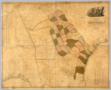
[Early, Eleazer, Sturges, Daniel]
Full Title
Map Of The State of Georgia Prepared from actual Surveys and other Documents for Eleazer Early By Daniel Sturges. Entered According to Act of Congress by Eleazer Early Proprietor. Engraved by Saml. Harrison 1818. Published & Sold By Eleazer Early Savannah Georgia and By John Melish & Samuel Harrison Philadelphia.
List No
4874.000
Note
Ristow mentions two editions with the same title, date and imprint, and with the later edition having "a number of changes and additions... in the southern Alabama portion of the map." We believe this copy is the first edition as we can detect no plate changes in the areas mentioned. This is the first large scale map of Georgia and it ranks in importance with the other large Southern State and Territory maps of the period: Wilson's South Carolina of 1822, Madison's Virginia of 1807 and 1818, Price and Strothers' North Carolina of 1808, and Vignoles' Florida of 1823. While it was undoubtedly the most accurate Georgia map when published, it quickly came under criticism by Tanner in his Geographical Memoir of 1823 for his American Atlas - he found the delineation of the Savannah River to be more correct in the Wilson 1822 Map of South Carolina. It has a lovely cartouche vignette, a table of distances, a statistical table, and "Remarks, Statistical and Geological." Streeter: "All in all an important and elaborate map of Georgia in the first part of the nineteenth century." Full color by county, without rollers.
Author
Arrowsmith, Aaron
Full Title
(Composite Map of) Map of the Island of Japan, Kurile &c. with the Adjacent Coasts of the Chinese Dominions and a Sketch of the River Amoor and the Baikal Lake Including the Trading Posts of Russia and China and their relative situations with Peking. Delineated by A. Arrowsmith 1811. London, Published by A. Arrowsmith, No. 10 Soho Square, Hydrographer to H.R.H. the Prince of Wales, 4th January, 1811. Additions to 1818.
List No
6733.003
Note
"Large and detailed map of Japan and the northeast coast of Asia.This map is a fine example of Arrowsmith's relentless updating of his maps. First issued in 1811, the map shows the tracks of some of the most important naval expeditions of the late eighteenth and early nineteenth century, which charted the waters around Japan, Korea, North East China, and Russia's Pacific coast. These include those made by La Perouse (1787); HMS 'Hindostan' which carried Lord George Macartney on his embassy to China; Broughton in HMS 'Providence' (1797); and the "track of the Russian's in 1805" - Admiral Krusenstern, who led the first Russian circumnavigation. For this 1818 edition Arrowsmith has also added the the track of HMS 'Alceste', and HC Ship 'Discovery' which, made several voyages around the Yellow Sea in 1816. Arrowsmith most probably drew upon the surgeon aboard the 'Alceste', John McCloed, and his book 'A narrative of a Voyage to the Yellow Sea' (1818), for the most up-to-date information." (Lyon and Turnbull).
Author
[Pinkerton, Alaskan Boundary Tribunal, Arrowsmith]
Full Title
(Facsimile) British Possessions in North America (portion). From Mr. Arrowsmith's Map of North America. Pinkerton's Modern Atlas. 1818. Alaska Boundary Tribunal, 1903. 8. Photo. Lith. by A. Hoen & Co. Baltimore, MD.
List No
0009.051
Note
Tinted. Relief shown by hachures.
Author
Depot General de la Marine
Full Title
Carte reduite du Grand Ocean compris entre l'Asie et l'Amerique, redigee d'apres les observations les plus recentes et publiee pour le Service des Vaisseaux Francais. Par ordre du Ministre de la Marine, au Depot General des Cartes et Plans de la Marine et des Colonies, en 1797. Corrigee en 1818. (Paris: Depot-general de la Marine, 1828)
List No
0233.002
Note
Engraved map. Emphasizes coastal detail. No. 288. Logo in lower left corner: Depot Gal. de la Marine. Prime meridian: Paris.
Author
[Reymann, Daniel Gottfried, Flemming, Carl]
Full Title
127 Merseburg
List No
10605.175
Note
Date is the latest date in the series. The range of dates of the sheets is 1822 to 1865
Author
Goujon, J
Full Title
Royaume de France divisé en 86 départemens, avec la distance comptée de Paris en lieues de poste aux chefs-lieux de départemens..., comprenant aussi les anciennes provinces / dressée par Hérisson en 1817 ; Ecrit par A. Pelicier, Myriamètres 10 [= 0m ; 030] ; lieues communes de France de 25 au degré 25 ; corrigée... par... J. Goujon. Gravé par B. Tardieu...
List No
10768.000
Note
First issue 1817, this copy corrected to 1818.
Author
Smith, Charles, 1800-1822
Full Title
(Composite text) A list of maps, published by C. Smith, map seller extraordinary to His Royal Highness the Prince Regent, No. 172, Strand. R. watts, Printer ... London.
List No
11164.000
Note
Catalog of maps and atlases in 4 pages, published by Charles Smith. Date estimated.
Author
Zurla, Placido, 1769-1834
Full Title
(Covers to) Sulle antiche mappe idro - geografiche lavorate in Venezia commentario del P. Ab. D. Placido Zurla. In Venezia Nella Tipografia Picotti MDCCCXVIII (1818).
List No
11171.001
Note
An ancient hydro-geographical work in Venice, by Placido Zurla in 96 pages of descriptive text, and three uncolored maps. Including: 1- Abbozzo della mappa dei viaggi di Marco Polo ... 2- Carta Da Navegar De Nicolo et Antonio Zeni Fvrono In Tramontana Lano M.CCC. LXXX. 3- Abbozzo Del Mappamondo Di F: Mauro Camaldolese Cosmografo Incomparabile alla Meta del Sec. XV. Text and maps includes: Marco Polo's travels, map showing his exploration routes in East Asia, also shows northern part of America, Sierra Nevada, etc., voyages of Nicolo and Antonio Zeno in North Atlantic, map showing North Atlantic, Greenland, Iceland and Lapland, etc., and the last map is a circular planisphere map of the world, made by Fra Mauro.
Author
Zurla, Placido, 1769-1834
Full Title
(Title Page to) Sulle antiche mappe idro - geografiche lavorate in Venezia commentario del P. Ab. D. Placido Zurla. In Venezia Nella Tipografia Picotti MDCCCXVIII (1818).
List No
11171.002
Note
An ancient hydro-geographical work in Venice, by Placido Zurla in 96 pages of descriptive text, and three uncolored maps. Including: 1- Abbozzo della mappa dei viaggi di Marco Polo ... 2- Carta Da Navegar De Nicolo et Antonio Zeni Fvrono In Tramontana Lano M.CCC. LXXX. 3- Abbozzo Del Mappamondo Di F: Mauro Camaldolese Cosmografo Incomparabile alla Meta del Sec. XV. Text and maps includes: Marco Polo's travels, map showing his exploration routes in East Asia, also shows northern part of America, Sierra Nevada, etc., voyages of Nicolo and Antonio Zeno in North Atlantic, map showing North Atlantic, Greenland, Iceland and Lapland, etc., and the last map is a circular planisphere map of the world, made by Fra Mauro.
Author
Zurla, Placido, 1769-1834
Full Title
(Composite text) Sulle antiche mappe idro - geografiche lavorate in Venezia commentario del P. Ab. D. Placido Zurla. In Venezia Nella Tipografia Picotti MDCCCXVIII (1818).
List No
11171.003
Note
An ancient hydro-geographical work in Venice, by Placido Zurla in 96 pages of descriptive text, and three uncolored maps. Including: 1- Abbozzo della mappa dei viaggi di Marco Polo ... 2- Carta Da Navegar De Nicolo et Antonio Zeni Fvrono In Tramontana Lano M.CCC. LXXX. 3- Abbozzo Del Mappamondo Di F: Mauro Camaldolese Cosmografo Incomparabile alla Meta del Sec. XV. Text and maps includes: Marco Polo's travels, map showing his exploration routes in East Asia, also shows northern part of America, Sierra Nevada, etc., voyages of Nicolo and Antonio Zeno in North Atlantic, map showing North Atlantic, Greenland, Iceland and Lapland, etc., and the last map is a circular planisphere map of the world, made by Fra Mauro.
Author
Zurla, Placido, 1769-1834
Full Title
Abbozzo della mappa dei viaggi di Marco Polo nella sala dello Scudo del Palazzo ducale di Venezia. (to accompany) Sulle antiche mappe idro - geografiche lavorate in Venezia.
List No
11171.004
Note
Uncolored map. Showing the travels of Marco Polo in East Asia. Map is orientated with south at the top. In the left hand the Northern part of America (Nuova Spagna) with "Terre Incognite d'Antropofagi" (Unknown land of cannibals), "Quiviria", "Sierra Nevada", "Grandes Corrientes", etc. Relief shown pictorially.
Author
[Zurla, Placido, 1769-1834, Niccolo�� Zeno]
Full Title
Carta Da Navegar De Nicolo et Antonio Zeni Fvrono In Tramontana Lano M.CCC.LXXX. (inset). (to accompany) Sulle antiche mappe idro - geografiche lavorate in Venezia.
List No
11171.005
Note
The Zeno map purports to illustrate the voyages of the author's ancestor and his brother at the end of the 14th century, first appeared in Venice in the year 1558 as a part of a small book that contained accounts of voyages in the North Atlantic and westward to the shores of America. It is, however, a fictitious map based upon Olaus Magnus's Carta marina, along with other 16th century maps, and was probably created to give Venice, the author's native city, the credit for discovering America more than a century ahead of Columbus. Estotiland (said to be inhabited by people of European lineage, but having its own language; it is perhaps Labrador) and Drogeo (perhaps Newfoundland) on this map appear to represent the eastern coast of America. Frisland, originally referred to Iceland, but was added along with Iceland on this map. It appeared on subsequent maps for the next hundred years. It may refer to the Faroe Islands. The meridians are marked.
Author
Wilkinson, Robert
Full Title
The World as Peopled by the Descendants of Noah Shewing the Countries Possessed by Shem, Ham & Japhet and their posterity after the confusion of tongues.
List No
1203.005
Author
Wilkinson, Robert
Full Title
Peloponnesus Exhibiting the Travels of Anacharsis between the Years CCC.LXIII & CCC.LVI before Christ (363 BC - 356 BC).
List No
1203.031
Note
Anacharsis was a Scythian "barbarian" philosopher who impressed the Greeks.
Author
Wilkinson, Robert
Full Title
Exhibiting the Travels of Anacharsis between the Years CCC.LXIII & CCC.LVI Before Christ (363 BC - 356 BC).
List No
1203.032
Note
Anacharsis was a Scythian "barbarian" philosopher who impressed the Greeks.
Author
Wilkinson, Robert
Full Title
Romanum Imperium.
List No
1203.052
Author
[Lizars, William Home, 1788-1859, Lizars, Daniel]
Full Title
(Covers to) New Edinburgh general atlas : or a complete collection of maps of the empires, kingdoms and states throughout the world. The maps drawn and engraved by W. & D. Lizars. Published by T. Brown & W. & D. Lizars, Edinburgh.
List No
13230.001
Author
[Lizars, William Home, 1788-1859, Lizars, Daniel]
Full Title
(Text Page to) New Edinburgh general atlas : or a complete collection of maps of the empires, kingdoms and states throughout the world. The maps drawn and engraved by W. & D. Lizars. Published by T. Brown & W. & D. Lizars, Edinburgh.
List No
13230.002
Author
[Lizars, William Home, 1788-1859, Lizars, Daniel]
Full Title
(Text Page to) New Edinburgh general atlas : or a complete collection of maps of the empires, kingdoms and states throughout the world. The maps drawn and engraved by W. & D. Lizars. Published by T. Brown & W. & D. Lizars, Edinburgh.
List No
13230.004
Author
[Lizars, William Home, 1788-1859, Lizars, Daniel]
Full Title
(Text Page to) New Edinburgh general atlas : or a complete collection of maps of the empires, kingdoms and states throughout the world. The maps drawn and engraved by W. & D. Lizars. Published by T. Brown & W. & D. Lizars, Edinburgh.
List No
13230.005
Note
Descriptive text. Edinburgh - Printed by William Blair.
Author
[Lizars, William Home, 1788-1859, Lizars, Daniel]
Full Title
(Text Page to) New Edinburgh general atlas : or a complete collection of maps of the empires, kingdoms and states throughout the world. The maps drawn and engraved by W. & D. Lizars. Published by T. Brown & W. & D. Lizars, Edinburgh.
List No
13230.006
Note
Continues: Descriptive text. Edinburgh - Printed by William Blair.
Author
[Lizars, William Home, 1788-1859, Lizars, Daniel]
Full Title
British Islands. Published by T. Brown & W. & D. Lizars, Edinr. (to accompany) New Edinburgh general atlas ... The maps drawn and engraved by W. & D. Lizars.
List No
13230.011
Note
Hand color engraved map. Shows administrative and political boundaries. Relief shown by hachures. Prime meridian is London.
Author
[Lizars, William Home, 1788-1859, Lizars, Daniel]
Full Title
England. Published by T. Brown & W. & D. Lizars, Edinburgh. (to accompany) New Edinburgh general atlas ... The maps drawn and engraved by W. & D. Lizars.
List No
13230.012
Note
Hand colored engraved map on 2 sheets. Shows administrative and political boundaries. Relief shown by hachures. Prime meridian is Greenwich.
Author
[Lizars, William Home, 1788-1859, Lizars, Daniel]
Full Title
Scotland. Published by T. Brown & W. & D. Lizars, Edinburgh. (to accompany) New Edinburgh general atlas ... The maps drawn and engraved by W. & D. Lizars.
List No
13230.013
Note
Hand colored engraved map on 2 sheets, with inset: Shetland Isles. Shows administrative. Relief shown by hachures. Prime meridian is Greenwich.
Author
[Lizars, William Home, 1788-1859, Lizars, Daniel]
Full Title
Ireland. Published by T. Brown & W. & D. Lizars, Edinburgh. (to accompany) New Edinburgh general atlas ... The maps drawn and engraved by W. & D. Lizars.
List No
13230.014
Note
Hand colored engraved map on 2 sheets. Shows administrative boundaries. Relief shown by hachures. Prime meridian is Greenwich.
Author
[Lizars, William Home, 1788-1859, Lizars, Daniel]
Full Title
Scandinavia. Published by T. Brown & W. & D. Lizars, Edinburgh. (to accompany) New Edinburgh general atlas ... The maps drawn and engraved by W. & D. Lizars.
List No
13230.015
Note
Hand colored engraved map, with inset: Iceland. Shows political boundaries. Relief shown by hachures. Prime meridian is London.
Author
[Lizars, William Home, 1788-1859, Lizars, Daniel]
Full Title
Denmark. Published by T. Brown & W. & D. Lizars, Edinburgh. (to accompany) New Edinburgh general atlas ... The maps drawn and engraved by W. & D. Lizars.
List No
13230.016
Note
Hand colored engraved map. Shows political boundaries. Relief shown by hachures. Prime meridian is London.
Author
[Lizars, William Home, 1788-1859, Lizars, Daniel]
Full Title
Poland. Published by T. Brown & W. & D. Lizars, Edinr. (to accompany) New Edinburgh general atlas ... The maps drawn and engraved by W. & D. Lizars.
List No
13230.018
Note
Hand colored engraved map. Shows political and administrative boundaries. Relief shown by hachures. Prime meridian is Greenwich. Includes legend.
Author
[Lizars, William Home, 1788-1859, Lizars, Daniel]
Full Title
Prussia. Published by T. Brown & W. & D. Lizars, Edinr. (to accompany) New Edinburgh general atlas ... The maps drawn and engraved by W. & D. Lizars.
List No
13230.019
Note
Hand colored engraved map. Shows political and administrative boundaries. Prime meridian is Greenwich.
Author
[Lizars, William Home, 1788-1859, Lizars, Daniel]
Full Title
Germany. Published by T. Brown & W. & D. Lizars, Edinr. (to accompany) New Edinburgh general atlas ... The maps drawn and engraved by W. & D. Lizars.
List No
13230.020
Note
Hand colored engraved map. Shows administrative boundaries. Prime meridian is London.
Author
[Lizars, William Home, 1788-1859, Lizars, Daniel]
Full Title
Lower Saxony. Published by T. Brown & W. & D. Lizars, Edinburgh. (to accompany) New Edinburgh general atlas ... The maps drawn and engraved by W. & D. Lizars.
List No
13230.021
Note
Hand colored engraved map. Shows administrative boundaries. Prime meridian is London.
Author
[Lizars, William Home, 1788-1859, Lizars, Daniel]
Full Title
Upper Saxony. Published by T. Brown & W. & D. Lizars, Edinburgh. (to accompany) New Edinburgh general atlas ... The maps drawn and engraved by W. & D. Lizars.
List No
13230.022
Note
Hand colored engraved map. Shows administrative boundaries. Relief shown by hachures.
Author
[Lizars, William Home, 1788-1859, Lizars, Daniel]
Full Title
Westphalia. Published by T. Brown & W. & D. Lizars, Edinburgh. (to accompany) New Edinburgh general atlas ... The maps drawn and engraved by W. & D. Lizars.
List No
13230.023
Note
Hand colored engraved map. Shows administrative boundaries. Relief shown by hachures. Prime meridian is Greenwich.
Author
[Lizars, William Home, 1788-1859, Lizars, Daniel]
Full Title
Upper & Lower Rhine. Published by T. Brown & W. & D. Lizars, Edinburgh. (to accompany) New Edinburgh general atlas ... The maps drawn and engraved by W. & D. Lizars.
List No
13230.024
Note
Hand colored engraved map. Shows administrative boundaries. Relief shown by hachures. Prime meridian is Greenwich.
Author
[Lizars, William Home, 1788-1859, Lizars, Daniel]
Full Title
Franconia. Published by T. Brown & W. & D. Lizars, Edinr. (to accompany) New Edinburgh general atlas ... The maps drawn and engraved by W. & D. Lizars.
List No
13230.025
Note
Hand colored engraved map. Shows administrative boundaries. Relief shown by hachures. Prime meridian is Greenwich.
Author
[Lizars, William Home, 1788-1859, Lizars, Daniel]
Full Title
Swabia. Published by T. Brown & W. & D. Lizars, Edinr. (to accompany) New Edinburgh general atlas ... The maps drawn and engraved by W. & D. Lizars.
List No
13230.026
Note
Hand colored engraved map. Shows administrative boundaries. Relief shown by hachures.
Author
[Lizars, William Home, 1788-1859, Lizars, Daniel]
Full Title
Bavaria. Published by T. Brown & W. & D. Lizars, Edinr. (to accompany) New Edinburgh general atlas ... The maps drawn and engraved by W. & D. Lizars.
List No
13230.027
Note
Hand colored engraved map. Shows administrative boundaries. Relief shown by hachures. Prime meridian is Greenwich.
Author
[Lizars, William Home, 1788-1859, Lizars, Daniel]
Full Title
Bohemia & Moravia. Published by T. Brown & W. & D. Lizars, Edinburgh. (to accompany) New Edinburgh general atlas ... The maps drawn and engraved by W. & D. Lizars.
List No
13230.028
Note
Hand colored engraved map. Shows administrative boundaries. Relief shown by hachures.
Author
[Lizars, William Home, 1788-1859, Lizars, Daniel]
Full Title
Austria. Published by T. Brown & W. & D. Lizars, Edinburgh. (to accompany) New Edinburgh general atlas ... The maps drawn and engraved by W. & D. Lizars.
List No
13230.029
Note
Hand colored engraved map. Shows administrative boundaries. Relief shown by hachures. Prime meridian is London.
Author
[Lizars, William Home, 1788-1859, Lizars, Daniel]
Full Title
Hungary & Transilvania. Published by T. Brown & W. & D. Lizars, Edinburgh. (to accompany) New Edinburgh general atlas ... The maps drawn and engraved by W. & D. Lizars.
List No
13230.030
Note
Hand colored engraved map. Shows administrative boundaries. Relief shown by hachures. Prime meridian is Greenwich.
Author
[Lizars, William Home, 1788-1859, Lizars, Daniel]
Full Title
Holland. Published by T. Brown & W. & D. Lizars, Edinburgh. (to accompany) New Edinburgh general atlas ... The maps drawn and engraved by W. & D. Lizars.
List No
13230.031
Note
Hand colored engraved map of Kingdom of the Netherlands. Shows administrative boundaries. Prime meridian is Greenwich.
Author
[Lizars, William Home, 1788-1859, Lizars, Daniel]
Full Title
Netherlands. Published by T. Brown & W. & D. Lizars, Edinburgh. (to accompany) New Edinburgh general atlas ... The maps drawn and engraved by W. & D. Lizars.
List No
13230.032
Note
Hand colored engraved map of the Kingdom of Netherlands, covers Belgium and Luxembourg. Shows administrative boundaries. Prime meridian is Greenwich.
Author
[Lizars, William Home, 1788-1859, Lizars, Daniel]
Full Title
France in departments. Published by T. Brown & W. & D. Lizars, Edinburgh. (to accompany) New Edinburgh general atlas ... The maps drawn and engraved by W. & D. Lizars.
List No
13230.033
Note
Hand colored engraved map, with inset map: Corsica. Shows administrative boundaries. Prime meridian is Greenwich. Relief shown by hachures.
Author
[Lizars, William Home, 1788-1859, Lizars, Daniel]
Full Title
France in provinces. Published by T. Brown & W. & D. Lizars, Edinburgh. (to accompany) New Edinburgh general atlas ... The maps drawn and engraved by W. & D. Lizars.
List No
13230.034
Note
Hand colored engraved map. Shows administrative boundaries. Prime meridian is Greenwich. Relief shown by hachures.
Author
[Lizars, William Home, 1788-1859, Lizars, Daniel]
Full Title
Switzerland. Published by T. Brown & W. & D. Lizars, Edinburgh. (to accompany) New Edinburgh general atlas ... The maps drawn and engraved by W. & D. Lizars.
List No
13230.035
Note
Hand colored engraved map. Shows administrative boundaries. Prime meridian is Greenwich. Relief shown by hachures and pictorially.
Author
[Lizars, William Home, 1788-1859, Lizars, Daniel]
Full Title
Spain and Portugal. Published by T. Brown & W. & D. Lizars, Edinburgh. (to accompany) New Edinburgh general atlas ... The maps drawn and engraved by W. & D. Lizars.
List No
13230.036
Note
Hand colored engraved map. Shows political and administrative boundaries. Prime meridian is Greenwich. Relief shown by hachures.
Author
[Lizars, William Home, 1788-1859, Lizars, Daniel]
Full Title
Italy. Published by T. Brown & W. & D. Lizars, Edinburgh. (to accompany) New Edinburgh general atlas ... The maps drawn and engraved by W. & D. Lizars.
List No
13230.037
Note
Hand colored engraved map. Shows administrative boundaries. Prime meridian is Greenwich. Relief shown by hachures.
Author
[Lizars, William Home, 1788-1859, Lizars, Daniel]
Full Title
Piedmont, Savoy & Milan. Published by T. Brown & W. & D. Lizars, Edinburgh. (to accompany) New Edinburgh general atlas ... The maps drawn and engraved by W. & D. Lizars.
List No
13230.038
Note
Hand colored engraved map. Shows administrative boundaries. Relief shown by hachures.
Author
[Lizars, William Home, 1788-1859, Lizars, Daniel]
Full Title
Turkey in Europe. Published by T. Brown & W. & D. Lizars, Edinburgh. (to accompany) New Edinburgh general atlas ... The maps drawn and engraved by W. & D. Lizars.
List No
13230.039
Note
Hand colored engraved map. Shows administrative boundaries. Relief shown by hachures. Prime meridian is Greenwich.
Author
[Lizars, William Home, 1788-1859, Lizars, Daniel]
Full Title
Turkey in Asia. Published by T. Brown & W. & D. Lizars, Edinburgh. (to accompany) New Edinburgh general atlas ... The maps drawn and engraved by W. & D. Lizars.
List No
13230.041
Note
Hand colored engraved map. Shows political and administrative boundaries. Relief shown by hachures. Prime meridian is Greenwich.
Author
[Lizars, William Home, 1788-1859, Lizars, Daniel]
Full Title
East India. Published by T. Brown & W. & D. Lizars, Edinburgh. (to accompany) New Edinburgh general atlas ... The maps drawn and engraved by W. & D. Lizars.
List No
13230.046
Note
Hand colored engraved map. Relief shown by hachures and pictorially. Prime meridian is Greenwich.
Author
Borghi, Bartolomeo, 1750-1821
Full Title
Le provincie che formano la parte dell'Est dell'Inghilterra, dell'A. B. Borghi. Firenze 1818.
List No
14255.036
Note
Engraved political map of eastern England, with hand-colored outlines delineating boundaries. Title translates to: [The provinces that form the part of the east of England]. Shows political boundaries, topography, drainage, coastlines and routes of travel. Relief shown pictorially. With latitudinal and longitudinal lines, as well as two bar scales. Imprint beneath title. Map is 22 x 29 cm, on sheet 35 x 47 cm. Descriptive text appears on prior plates (27-28).
Author
Borghi, Bartolomeo, 1750-1821
Full Title
Il Regno Belgico ovvero de Paesi Bassi, dell'A. B. Borghi. Firenze 1818. Ago Costa Inc.
List No
14255.040
Note
Engraved political map of Belgium and the Netherlands, with hand-colored outlines delineating boundaries. Title translates to: [The Belgian Kingdom, or the Netherlands]. Shows political boundaries, topography, drainage, coastlines, islands and routes of travel. Relief shown pictorially. With latitudinal and longitudinal lines, as well as three bar scales. Imprint beneath title. Map is 30 x 22 cm, on sheet 47 x 35 cm.
Author
Borghi, Bartolomeo, 1750-1821
Full Title
(Text Page to) Primo prospetto Istorico-Politico-Civile-Naturale dell'Impero Austria, e della Confederazione Germanica per l'intelligenza delle Carte dell'Atlante, dell'A. B. Borghi. Firenze, 1818, Presso Giovanni Marenigh.
List No
14255.056
Note
Descriptive text accompanying the subsequent maps of the Austrian Empire and German Confederation on plates 56-62. Title translates to: [First historical-political-civil-natural prospectus of the Austrian Empire, and of the German Confederation ... ]. Includes a table with political divisions. First of two plates (54-55) of descriptive text on the Austrian Empire and German Confederation. Imprint at bottom right.
Author
Borghi, Bartolomeo, 1750-1821
Full Title
(Text Page to) Secondo prospetto Istorico-Politico-Civile-Naturale dell'Impero Austria, e della Confederazione Germanica per l'intelligenza delle Carte dell'Atlante, dell'A. B. Borghi. Firenze, 1818, Presso Giovanni Marenigh.
List No
14255.057
Note
Descriptive text accompanying the subsequent maps of the Austrian Empire and German Confederation on plates 56-62. Title translates to: [First historical-political-civil-natural prospectus of the Austrian Empire, and of the German Confederation ... ]. Includes a table with political divisions. Second of two plates (54-55) of descriptive text on the Austrian Empire and German Confederation. Imprint at bottom right.
Author
Borghi, Bartolomeo, 1750-1821
Full Title
(Text Page to) Prospetto Istorico-Politico-Civile-Naturale del regno di Prussia, destinato per l'intelligenza delle Carte dell'Atlante, dell'A. B. Borghi. Firenze, 1818, Presso Giovanni Marenigh.
List No
14255.066
Note
Descriptive text accompanying the subsequent maps of the Austrian Empire and German Confederation on plates 64-67. Title translates to: [First historical-political-civil-natural prospectus of the Kingdom of Prussia ... ]. Includes a table with political divisions. Imprint at bottom right.
Author
Borghi, Bartolomeo, 1750-1821
Full Title
La Bassa Germania con tutti i cambiamenti fatti ivi fino al presente, dell'A. Bartolommeo Borghi. Firenze 1818 (1).
List No
14255.067
Note
Engraved political map of southern Germany, with hand-colored outlines delineating boundaries. Title translates to: [Lower Germany ..]. Shows political boundaries, topography, drainage and routes of travel. Relief shown pictorially. With latitudinal and longitudinal lines, as well as two bar scales. Imprint beneath title. First (southeast) in a series of four sheets that together comprise the full map (plates 64-67). Sheet is 22 x 30 cm, on sheet 35 x 47 cm. Descriptive text appears on prior plate (63).
Author
Borghi, Bartolomeo, 1750-1821
Full Title
La Bassa Germania con tutti i cambiamenti fatti ivi fino al presente, dell'A. Bartolommeo Borghi. Firenze 1818 (2).
List No
14255.068
Note
Engraved political map of southern Germany, with hand-colored outlines delineating boundaries. Title translates to: [Lower Germany ..]. Shows political boundaries, topography, drainage and routes of travel. Relief shown pictorially. With latitudinal and longitudinal lines. Additionally, includes two bar scales on first sheet. Second (southwest) in a series of four sheets that together comprise the full map (plates 64-67). (Title and imprint taken from first sheet.) Sheet is 22 x 30 cm, on sheet 35 x 47 cm. Descriptive text appears on prior plate (63).
Author
Borghi, Bartolomeo, 1750-1821
Full Title
La Bassa Germania con tutti i cambiamenti fatti ivi fino al presente, dell'A. Bartolommeo Borghi. Firenze 1818 (3).
List No
14255.069
Note
Engraved political map of southern Germany, with hand-colored outlines delineating boundaries. Title translates to: [Lower Germany ..]. Shows political boundaries, topography, drainage, coastlines and routes of travel. Relief shown pictorially. With latitudinal and longitudinal lines. Additionally, includes two bar scales on first sheet. Third (northeast) in a series of four sheets that together comprise the full map (plates 64-67). (Title and imprint taken from first sheet.) Sheet is 22 x 30 cm, on sheet 35 x 47 cm. Descriptive text appears on prior plate (63).
Author
Borghi, Bartolomeo, 1750-1821
Full Title
La Bassa Germania con tutti i cambiamenti fatti ivi fino al presente, dell'A. Bartolommeo Borghi. Firenze 1818 (4).
List No
14255.070
Note
Engraved political map of southern Germany, with hand-colored outlines delineating boundaries. Title translates to: [Lower Germany ..]. Shows political boundaries, topography, drainage, coastlines and routes of travel. Relief shown pictorially. With latitudinal and longitudinal lines. Additionally, includes two bar scales on first sheet. Fourth (northwest) in a series of four sheets that together comprise the full map (plates 64-67). (Title and imprint taken from first sheet.) Sheet is 22 x 30 cm, on sheet 35 x 47 cm. Descriptive text appears on prior plate (63).
Author
Borghi, Bartolomeo, 1750-1821
Full Title
(Text Page to) Prospetto Istorico-Politico-Civile-Naturale della Tartaria Russa, ossia Siberia, e della Tartaria Indipendente per l'illustrazione della Carte dell'Atlante, dell'A. B. Borghi. Firenze 1818, Presso Giovanni Marenigh.
List No
14255.130
Note
Descriptive text accompanying the subsequent map of Tartary on plate 126. Title translates to: [Historical-political-civil-natural prospectus of Russian Tartary, that is, Siberia, and of Independent Tartary ... ]. Imprint at bottom left.
Author
Borghi, Bartolomeo, 1750-1821
Full Title
La Siberia o sia Russia Asiatica e la Tartaria Cinese, dell'A. B. Borghi. Firenze 1818.
List No
14255.131
Note
Engraved political map of Russian and Chinese Tartary, with hand-colored outlines delineating boundaries. Title translates to: [Siberia or both Asian Russia and Chinese Tartary]. Shows political boundaries, topography, drainage, coastlines, islands and routes of travel. Relief shown pictorially. With latitudinal and longitudinal lines, as well as three bar scales. Imprint beneath title. Map is 22 x 30 cm, on sheet 35 x 47 cm. Descriptive text appears on prior plate (125).
Author
Borghi, Bartolomeo, 1750-1821
Full Title
L'Impero della China e l'mpero del Giappone, dell'A. B. Borghi. Firenze 1818.
List No
14255.133
Note
Engraved political map of China and Japan, with hand-colored outlines delineating boundaries. Title translates to: [The Empire of China and the Empire of Japan]. Shows political boundaries, topography, drainage, coastlines, islands and routes of travel. Relief shown pictorially. With latitudinal and longitudinal lines, as well as two bar scales. Imprint beneath title. Map is 23 x 30 cm, on sheet 35 x 47 cm. Descriptive text appears on prior plate (127).
Author
Borghi, Bartolomeo, 1750-1821
Full Title
Parte Meridionale della Chinapropria, dell'A. B. Borghi. Firenze 1818.
List No
14255.135
Note
Engraved political map of southern China, with hand-colored outlines delineating boundaries. Title translates to: [Southern part of the Chinese Empire]. Shows political boundaries, topography, drainage, coastlines, islands and routes of travel. Relief shown pictorially. With latitudinal and longitudinal lines, as well as two bar scales. Imprint beneath title. Map is 22 x 30 cm, on sheet 35 x 47 cm. Descriptive text appears on prior plate (127).
Author
Borghi, Bartolomeo, 1750-1821
Full Title
Turchia d'Asia, dell'A. B. Borghi. Firenze 1818.
List No
14255.136
Note
Engraved political map of Turkey, with hand-colored outlines delineating boundaries. Title translates to: [Turkey of Asia]. Shows political boundaries, topography, drainage, coastlines, islands and routes of travel. Relief shown pictorially. With latitudinal and longitudinal lines, as well as two bar scales. Imprint beneath title. Map is 21 x 31 cm, on sheet 35 x 47 cm.
Author
Borghi, Bartolomeo, 1750-1821
Full Title
(Text Page to) Prospetto Istorico-Politico-Civile-Naturale dell'Impero Persiano, nel quale si comprende la Persia propriamente detta ossia Persia occidentale, e il regno di Kandahar o Persia orientale, destinato per l'intelligenza dell'Atlante, dell'A. B. Borghi. Firenze 1818, Presso Giovanni Marenigh.
List No
14255.137
Note
Descriptive text accompanying the subsequent map of the Persian Empire on plate 133. Title translates to: [Historical-political-civil-natural prospectus of the Persian Empire, which includes Persia proper, or western Persia, and the Kingdom of Kandahar, or Eastern Persia ... ]. Imprint at bottom left and right. (Plate misprinted as 131, when actually 132, which is penciled above misprint.)
Author
Borghi, Bartolomeo, 1750-1821
Full Title
I Regni di Persia e di Afgania e la Gran Bukarria, dell'Ab. Bo. Borghi. Firenze 1818.
List No
14255.138
Note
Engraved political map of Persia and Afghanistan, with hand-colored outlines delineating boundaries. Title translates to: [The Kingdoms of Persia and Afghanistan and the Great Bukarria]. Shows political boundaries, topography, drainage, coastlines and routes of travel. Relief shown pictorially. With latitudinal and longitudinal lines, as well as two bar scales. Imprint beneath title. Map is 22 x 30 cm, on sheet 35 x 47 cm. Descriptive text appears on prior plate [132].
Author
Borghi, Bartolomeo, 1750-1821
Full Title
L'India di qua Dal Gange, dell'Ab. B. Borghi. Firenze 1818.
List No
14255.140
Note
Engraved political map of India (south of the Ganges River), with hand-colored outlines delineating boundaries. Title translates to: [India, on this side of the Ganges River]. Shows political boundaries, topography, drainage, coastlines, islands and routes of travel. Relief shown pictorially. With latitudinal and longitudinal lines, as well as two bar scales. Imprint beneath title. Map is 31 x 23 cm, on sheet 47 x 35 cm. Descriptive text appears on prior plate (134).
Author
Borghi, Bartolomeo, 1750-1821
Full Title
India di là dal Gange, ossia l'Impero Birmanno, dell'A. B. Borghi. Firenze 1818.
List No
14255.142
Note
Engraved political map of India (north of the Ganges River) and the Burmese Empire, with hand-colored outlines delineating boundaries. Title translates to: [India beyond the Ganges, that is the Burmese Empire]. Shows political boundaries, topography, drainage, coastlines, islands and routes of travel. Relief shown pictorially. With latitudinal and longitudinal lines, as well as a bar scale. Imprint beneath title. Map is 30 x 22 cm, on sheet 47 x 35 cm. Descriptive text appears on prior plate (136).
Author
Borghi, Bartolomeo, 1750-1821
Full Title
Supplemento alle Carte d'Asia ed Africa cioè l'Arabia la Nubia l'Abissinia, dell'A. B. Borghi. Firenze 1818. Ago. Costa Inc.
List No
14255.144
Note
Engraved political map of northeastern Africa (including the region of Nubia and Abyssinia [present-day Ethiopia]) and the Arabian Peninsula, with hand-colored outlines delineating boundaries. Title translates to: [Supplement to the maps of Asia and Africa, that is Arabia, Nubia, Abyssinia]. Shows political boundaries, topography, drainage, coastlines, islands and routes of travel. Relief shown pictorially. With latitudinal and longitudinal lines, as well as a bar scale. Imprint beneath title. Map is 22 x 29 cm, on sheet 35 x 47 cm. Descriptive text appears on prior plate (138).
Author
Borghi, Bartolomeo, 1750-1821
Full Title
(Text Page to) Prospetto Istorico-Politico-Civile-Naturale delle Coste di Barberia, ossia degli Stati Maomettani posti al Nord dell'Affrica, per servire d'illustrazione alle Carte dell'Atlante, dell'A. B. Borghi. Firenze 1818, Presso Giovanni Marenigh.
List No
14255.147
Note
Descriptive text accompanying the subsequent maps of the Barbary Coast on plate 143. Title translates to: [Historical-political-civil-natural prospectus of the Coasts of Barbary, that is of the Mohammedan States located in the North of Africa ... ]. Includes a table with political divisions. Imprint at bottom left.
Author
Borghi, Bartolomeo, 1750-1821
Full Title
Le Coste di Barberia parte Occidentale, dell'A. B. Borghi. Firenze 1818. -- Le Coste di Barberia parte Orientale.
List No
14255.148
Note
Two engraved historical and political maps - western and eastern parts - of the Barbary Coast of Northern Africa, with hand-colored outlines delineating boundaries. Titles translate to: [The Coast of Barbary, western part] -- [The Coast of Barbary, eastern part]. Maps show political boundaries, topography, drainage, coastlines, islands and routes of travel. Relief shown pictorially. With latitudinal and longitudinal lines, as well as a bar scale on second map. Imprint beneath title of first map. Together, maps are 30 x 22 cm, on sheet 47 x 35 cm. Descriptive text appears on prior plate (142).
Author
Borghi, Bartolomeo, 1750-1821
Full Title
(Text Page to) Prospetto Istorico-Politico-Civile-Naturale dell'Egitto, e dell'Abissinia, per servire d'illustrazione alle Carte dell'Atlante, dell'A. B. Borghi. Firenze 1818, Presso Giovanni Marenigh.
List No
14255.149
Note
Descriptive text accompanying the subsequent maps of Egypt and Abyssinia [present-day Ethiopia] on plates 145-147. Title translates to: [Historical-political-civil-natural prospectus of Egypt, and of Abyssinia ... ]. Includes a table with political divisions. Imprint at bottom right.
Author
Borghi, Bartolomeo, 1750-1821
Full Title
L'Egitto, dell'A. B. Borghi. Firenze 1818.
List No
14255.150
Note
Engraved political map of Egypt, with hand-colored outlines delineating boundaries. Title translates to: [Egypt]. Shows political boundaries, topography, drainage, coastlines, islands and routes of travel. Relief shown pictorially. With latitudinal and longitudinal lines, as well as a bar scale. Imprint beneath title. Map is 30 x 22 cm, on sheet 47 x 35 cm. Descriptive text appears on prior plate (144).
Author
Borghi, Bartolomeo, 1750-1821
Full Title
Senegambia come si conosce in oggi e La Guinea, dell'A. B. Borghi. Firenze 1818. Guis. Poggiali inc.
List No
14255.151
Note
Engraved political map of Senegambia [present-day Senegal and Sierra Leone] and Guinea, with hand-colored outlines delineating boundaries. Title translates to: [Senegambia as it is known today and Guinea]. Shows political boundaries, topography, drainage, coastlines, islands and routes of travel. Relief shown pictorially. With latitudinal and longitudinal lines, as well as a bar scale. Imprint beneath title. Map is 22 x 30 cm, on sheet 35 x 47 cm. Descriptive text appears on prior plate (144).
Author
Borghi, Bartolomeo, 1750-1821
Full Title
L'Africa Meridionale, dell'A. B. Borghi. Firenze 1818.
List No
14255.152
Note
Engraved political map of Southern Africa, with hand-colored outlines delineating boundaries. Title translates to: [Southern Africa]. Shows political boundaries, topography, drainage, coastlines, islands and routes of travel. Relief shown pictorially. With latitudinal and longitudinal lines, as well as a bar scale. Imprint beneath title. Map is 21 x 29 cm, on sheet 35 x 47 cm. Descriptive text appears on prior plate (144).
Author
Borghi, Bartolomeo, 1750-1821
Full Title
(Text Page to) Prospetto Istorico-Politico-Civile-Naturale della Republica degli Stati Uniti dell'America Settentrionale, per servire d'illustrazione alle Carte dell'Atlante, dell'A. B. Borghi. Firenze 1818, Presso Giovanni Marenigh.
List No
14255.155
Note
Descriptive text accompanying the subsequent map of the United States on plates 151-154. Title translates to: [Historical-political-civil-natural prospectus of the Republic of the United States of North America ... ]. Includes a table with political divisions. Imprint at bottom right.
Author
Borghi, Bartolomeo, 1750-1821
Full Title
I Stati Uniti nell'America Settentrionale, dell'A. Bo. Borghi. Firenze 1818. Inc. nello Studio Giarrè (1).
List No
14255.156
Note
Engraved political map of the United States, with hand-colored outlines delineating boundaries. Title translates to: [The United States in North America]. Shows political boundaries, topography, drainage, coastlines, islands and routes of travel. Features territories of indigenous peoples, such as the Chickasaw. Relief shown pictorially. With latitudinal and longitudinal lines, as well as two bar scales. Imprint beneath title. First (southeast) in a series of four sheets that together comprise the full map (plates 151-154). Sheet is 22 x 29 cm, on sheet 35 x 47 cm. Descriptive text appears on prior plate (150).
Author
Borghi, Bartolomeo, 1750-1821
Full Title
I Stati Uniti nell'America Settentrionale, dell'A. Bo. Borghi. Firenze 1818. Inc. nello Studio Giarrè (2).
List No
14255.157
Note
Engraved political map of the United States, with hand-colored outlines delineating boundaries. Title translates to: [The United States in North America]. Shows political boundaries, topography, drainage, coastlines, islands and routes of travel. Features territories of indigenous peoples, such as the Winebago. Relief shown pictorially. With latitudinal and longitudinal lines. Additionally, includes two bar scales on first sheet. Imprint beneath title. Second (northeast) in a series of four sheets that together comprise the full map (plates 151-154). (Title and imprint taken from first sheet.) Sheet is 22 x 29 cm, on sheet 35 x 47 cm. Descriptive text appears on prior plate (150).
Author
Borghi, Bartolomeo, 1750-1821
Full Title
I Stati Uniti nell'America Settentrionale, dell'A. Bo. Borghi. Firenze 1818. Inc. nello Studio Giarrè (3).
List No
14255.158
Note
Engraved political map of the United States, with hand-colored outlines delineating boundaries. Title translates to: [The United States in North America]. Shows political boundaries, topography, drainage, shorelines and routes of travel. Features territories of indigenous peoples, such as the Shoshone. Relief shown pictorially. With latitudinal and longitudinal lines. Additionally, includes two bar scales on first sheet. Imprint beneath title. Third (northwest) in a series of four sheets that together comprise the full map (plates 151-154). (Title and imprint taken from first sheet.) Sheet is 22 x 29 cm, on sheet 35 x 47 cm. Descriptive text appears on prior plate (150).
Author
Borghi, Bartolomeo, 1750-1821
Full Title
I Stati Uniti nell'America Settentrionale, dell'A. Bo. Borghi. Firenze 1818. Inc. nello Studio Giarrè (4).
List No
14255.159
Note
Engraved political map of the United States, with hand-colored outlines delineating boundaries. Title translates to: [The United States in North America]. Shows political boundaries, topography, drainage, shorelines and routes of travel. Features territories of indigenous peoples, such as the Coahuila. Relief shown pictorially. With latitudinal and longitudinal lines. Additionally, includes two bar scales on first sheet. Imprint beneath title. Fourth (southwest) in a series of four sheets that together comprise the full map (plates 151-154). (Title and imprint taken from first sheet.) Also, with inset: [Nuova Georgia and Nuova Albion] [= New Georgia and New Albion]. Sheet is 22 x 29 cm, on sheet 35 x 47 cm. Descriptive text appears on prior plate (150).
Author
Borghi, Bartolomeo, 1750-1821
Full Title
(Composite map of) I Stati Uniti nell'America Settentrionale, dell'A. Bo. Borghi. Firenze 1818. Inc. nello Studio Giarrè (1-4).
List No
14255.160
Note
Engraved political map of the United States, with hand-colored outlines delineating boundaries. Title translates to: [The United States in North America]. Shows political boundaries, topography, drainage, shorelines and routes of travel. Features territories of indigenous peoples, such as the Coahuila. Relief shown pictorially. With latitudinal and longitudinal lines. Additionally, includes two bar scales on first sheet. Imprint beneath title. Four sheets that together comprise the full map (plates 151-154). (Title and imprint taken from first sheet.) Descriptive text appears on prior plate (150).
Author
Borghi, Bartolomeo, 1750-1821
Full Title
Possessioni Spagnole nell'America Settentrionale cioè il Nuovo e Vecchio Messico e le Floride, dell'A. B. Borghi. Firenze 1818.
List No
14255.161
Note
Engraved political map of the Spanish colonies in North America (Mexico, New Mexico and Florida), with hand-colored outlines delineating boundaries. Title translates to: [Spanish possessions in North America, that is, New and Old Mexico and Florida]. Shows political boundaries, topography, drainage, coastlines, islands and routes of travel. Features territories of indigenous peoples, such as the Navajo. Relief shown pictorially. With latitudinal and longitudinal lines, as well as two bar scales. Imprint beneath title. Map is 22 x 29 cm, on sheet 35 x 47 cm.
Author
Borghi, Bartolomeo, 1750-1821
Full Title
Possessioni Spagnole nell'America Meridionale parte al Nord, dell'A. B. Borghi. Firenze 1818. Inc. nello Studio Giarrè.
List No
14255.166
Note
Engraved political map of the Spanish colonies in the northern part of South America, with hand-colored outlines delineating boundaries. Title translates to: [Spanish possessions in South America, northern part]. Shows political boundaries, topography, drainage, coastlines, islands and routes of travel. Features territories of indigenous peoples, such as the Yaruro. Relief shown pictorially. With latitudinal and longitudinal lines, as well as two bar scales. Imprint beneath title. Map is 22 x 30 cm, on sheet 35 x 47 cm. First in a series of three maps representing the Spanish colonies in South America (plates 160-162). Descriptive text appears on prior plate (158).
Author
Borghi, Bartolomeo, 1750-1821
Full Title
Parte Media delle Possessioni Spagnole nell'America Meridionale, dell'A. B. Borghi. Firenze 1818.
List No
14255.167
Note
Engraved political map of the Spanish colonies in the central part of South America, with hand-colored outlines delineating boundaries. Title translates to: [Middle Part of Spanish Possessions in South America]. Shows political boundaries, topography, drainage, coastlines, islands and routes of travel. Features territories of indigenous peoples, such as the Pampas. Relief shown pictorially. With latitudinal and longitudinal lines, as well as two bar scales. Imprint beneath title. Map is 22 x 30 cm, on sheet 35 x 47 cm. Second in a series of three maps representing the Spanish colonies in South America (plates 160-162). Descriptive text appears on prior plate (158).
Author
Borghi, Bartolomeo, 1750-1821
Full Title
Possessioni Spagnole nell'America Meridionale parte del Sud, dell'A. B. Borghi. Firenze 1818. A. Costa. Inc.
List No
14255.168
Note
Engraved political map of the Spanish colonies in the southern part of South America, with hand-colored outlines delineating boundaries. Title translates to: [Spanish possessions in South America, southern part]. Shows political boundaries, topography, drainage, coastlines, islands and routes of travel. Features territories of indigenous peoples, such as the Charrúa. Relief shown pictorially. With latitudinal and longitudinal lines, as well as two bar scales. Imprint beneath title. Map is 22 x 30 cm, on sheet 35 x 47 cm. Third in a series of three maps representing the Spanish colonies in South America (plates 160-162). Descriptive text appears on prior plate (158).
Author
Borghi, Bartolomeo, 1750-1821
Full Title
Parte Orientale dell America Meridionale o sia il Brasile fogli due, dell'A. B. Borghi. Firenze 1818. Gius. Poggiali inc. (1).
List No
14255.169
Note
Engraved political map of northeastern South America (including Brazil), with hand-colored outlines delineating boundaries. Title translates to: [Eastern part of South America, or both Brazil folios]. Shows political boundaries, topography, drainage, coastlines, islands and routes of travel. Features territories of indigenous peoples, such as the Toba. Relief shown pictorially. With latitudinal and longitudinal lines. Additionally, includes four bar scales and a descriptive note on second sheet. Imprint beneath title. First (northern) in a series of two sheets that together comprise the full map (plates 163-164). Sheet is 23 x 29 cm, on sheet 35 x 47 cm. Descriptive text appears on prior plate (158).
Author
Borghi, Bartolomeo, 1750-1821
Full Title
Parte Orientale dell America Meridionale o sia il Brasile fogli due, dell'A. B. Borghi. Firenze 1818. Gius. Poggiali inc. (2).
List No
14255.170
Note
Engraved political map of northeastern South America (including Brazil), with hand-colored outlines delineating boundaries. Title translates to: [Eastern part of South America, or both Brazil folios]. Shows political boundaries, topography, drainage, coastlines, islands and routes of travel. Features territories of indigenous peoples, such as the Kayapo. Relief shown pictorially. With latitudinal and longitudinal lines, as well as four bar scales and a descriptive note. Second (southern) in a series of two sheets that together comprise the full map (plates 163-164). (Title and imprint taken from first sheet.) Sheet is 22 x 29 cm, on sheet 35 x 47 cm. Descriptive text appears on prior plate (158).
Author
Borghi, Bartolomeo, 1750-1821
Full Title
(Composite map of) Parte Orientale dell America Meridionale o sia il Brasile fogli due, dell'A. B. Borghi. Firenze 1818. Gius. Poggiali inc. (1-2).
List No
14255.171
Note
Composite of two Brazil sheets. Engraved political map of northeastern South America (including Brazil), with hand-colored outlines delineating boundaries. Title translates to: [Eastern part of South America, or both Brazil folios]. Shows political boundaries, topography, drainage, coastlines, islands and routes of travel. Features territories of indigenous peoples, such as the Kayapo. Relief shown pictorially. With latitudinal and longitudinal lines, as well as four bar scales and a descriptive note. Second (southern) in a series of two sheets that together comprise the full map (plates 163-164). (Title and imprint taken from first sheet.) Sheet is 22 x 29 cm, on sheet 35 x 47 cm. Descriptive text appears on prior plate (158).
Author
[Spain. Dirección de Trabajos Hidrográficos, Ferrer y Cafranga, Joaquín María de, 1777-1861]
Full Title
Plano de la Aguadilla.
List No
14322.005
Note
Nautical chart showing the port of Aguadilla, Puerto Rico. Features harbor soundings, coastal elevations, vegetation, drainage and names of capes, points, islands and other geographical points of interest. Relief shown with hachures. Oriented with north toward top of sheet. Includes coordinate points, latitudinal and longitudinal lines, a compass rose, bar scale and explanatory note. Section title in top margin: Ia. de Pto. Rico. Chart is 24 x 18 cm, on sheet 35 x 28 cm. Appears in Parte primera.
Author
[Spain. Dirección de Trabajos Hidrográficos, Ferrer y Cafranga, Joaquín María de, 1777-1861]
Full Title
Plano de la Ensenada de Mayaguez.
List No
14322.006
Note
Nautical chart showing the port of Mayagüez, Puerto Rico. Features harbor soundings, coastal elevations, vegetation, drainage and names of capes, points, islands and other geographical points of interest. Relief shown with hachures. Oriented with north toward top of sheet. Includes coordinate points, latitudinal and longitudinal lines, a compass rose, bar scale and explanatory note. Section title in top margin: Ia. de Pto. Rico. Chart is 24 x 18 cm, on sheet 35 x 28 cm. Appears in Parte primera.
Author
[Spain. Dirección de Trabajos Hidrográficos, Ferrer y Cafranga, Joaquín María de, 1777-1861]
Full Title
Plano del Pto de San Tómas.
List No
14322.008
Note
Nautical chart showing the port of San Tómas [Saint Thomas], Virgin Islands (United States). Features harbor soundings, coastal elevations, vegetation, drainage and names of capes, points, islands and other geographical points of interest. Relief shown with hachures. Oriented with north toward top of sheet. Includes coordinate points, latitudinal and longitudinal lines, a compass rose, bar scale and explanatory note. Section title in right margin: S. Tomas. Chart is 18 x 24 cm, on sheet 28 x 35 cm. Appears in Parte primera.
Author
[Spain. Dirección de Trabajos Hidrográficos, Ferrer y Cafranga, Joaquín María de, 1777-1861]
Full Title
Plano del Puerto principal de la Tortola.
List No
14322.009
Note
Nautical chart showing the port of Tortola, Virgin Islands (British). Features harbor soundings, coastal elevations, vegetation, drainage and names of capes, points, islands and other geographical points of interest. Relief shown with hachures. Oriented with north toward top of sheet. Includes coordinate points, latitudinal and longitudinal lines, a compass rose, bar scale and explanatory note. Section title in right margin: S. Tomas. Chart is 18 x 24 cm, on sheet 28 x 35 cm. Appears in Parte primera.
Author
[Spain. Dirección de Trabajos Hidrográficos, Ferrer y Cafranga, Joaquín María de, 1777-1861]
Full Title
Plano de Pto. Grande situado en la Costa N.
List No
14322.011
Note
Nautical chart showing the port of Grande on Gorda Island, Virgin Islands (British). Features harbor soundings, coastal elevations, vegetation, drainage and names of capes, points, islands and other geographical points of interest. Relief shown with hachures. Oriented with north toward top of sheet. Includes coordinate points, latitudinal and longitudinal lines, a compass rose, bar scale and explanatory note. Section title in right margin: Ia. Virgen Gorda. Chart is 18 x 24 cm, on sheet 28 x 35 cm. Appears in Parte primera.
Author
[Spain. Dirección de Trabajos Hidrográficos, Ferrer y Cafranga, Joaquín María de, 1777-1861]
Full Title
Plano del Puerto del Carenero.
List No
14322.014
Note
Nautical chart showing the port of Carenero, Panama. Features harbor soundings, coastal elevations, vegetation, roads and names of capes, points, islands and other geographical points of interest. Relief shown with hachures. Oriented with north toward top of sheet. Includes coordinate points, latitudinal and longitudinal lines, a compass rose, bar scale and explanatory note. Section title in right margin: Ia. Sta. Lucia. Chart is 18 x 24 cm, on sheet 28 x 35 cm. Appears in Parte primera.
Author
[Spain. Dirección de Trabajos Hidrográficos, Ferrer y Cafranga, Joaquín María de, 1777-1861]
Full Title
Plano de la Rada y Carenero de San Jorge.
List No
14322.015
Note
Nautical chart showing the port of San Jorge [Saint George's], Granada [Grenada]. Features harbor soundings, coastal elevations, vegetation, drainage and names of capes, points, islands and other geographical points of interest. Relief shown with hachures. Oriented with north toward top of sheet. Includes coordinate points, latitudinal and longitudinal lines, a compass rose, bar scale and explanatory note. Section title in right margin: Ia. Granada. Chart is 24 x 18 cm, on sheet 35 x 28 cm. Appears in Parte primera.
Author
[Spain. Dirección de Trabajos Hidrográficos, Ferrer y Cafranga, Joaquín María de, 1777-1861]
Full Title
Plano de la Rada de Rockly.
List No
14322.016
Note
Nautical chart showing the port of Rockly, Tábago [Tobago]. Features harbor soundings, coastal elevations, vegetation, drainage and names of capes, points, islands and other geographical points of interest. Relief shown with hachures. Oriented with north toward top of sheet. Includes coordinate points, latitudinal and longitudinal lines, a compass rose, bar scale and explanatory note. Section title in right margin: Ia. de Tábago. Chart is 18 x 24 cm, on sheet 28 x 35 cm. Appears in Parte primera.
Author
[Spain. Dirección de Trabajos Hidrográficos, Ferrer y Cafranga, Joaquín María de, 1777-1861]
Full Title
Plano del Puerto de Chaguaramas.
List No
14322.017
Note
Nautical chart showing the port of Chaguaramas, Trinidad. Features harbor soundings, coastal elevations, vegetation, drainage and names of capes, points, islands and other geographical points of interest. Relief shown with hachures. Oriented with north toward top of sheet. Includes coordinate points, latitudinal and longitudinal lines, a compass rose, bar scale and explanatory note. Section title in right margin: Ia. de Trinidad. Chart is 18 x 24 cm, on sheet 28 x 35 cm. Appears in Parte primera.
Author
[Spain. Dirección de Trabajos Hidrográficos, Ferrer y Cafranga, Joaquín María de, 1777-1861]
Full Title
Ensena. de Unare.
List No
14322.021
Note
Nautical chart showing the port of the Unare River, Venezuela. Features harbor soundings, coastal elevations, vegetation, drainage and names of capes, points, islands and other geographical points of interest. Relief shown with hachures. Oriented with north toward top of sheet. Includes coordinate points, latitudinal and longitudinal lines, a compass rose, bar scale and explanatory note. Section title in top margin: Costa de Tierra Firme. Chart is 17 x 26 cm, on sheet 28 x 35 cm. Appears in Parte segunda.
Author
[Spain. Dirección de Trabajos Hidrográficos, Ferrer y Cafranga, Joaquín María de, 1777-1861]
Full Title
Ensenadas de Pto. Santo.
List No
14322.022
Note
Nautical chart showing the port of Santos, Brazil. Features harbor soundings, coastal elevations, vegetation, drainage and names of capes, points, islands and other geographical points of interest. Relief shown with hachures. Oriented with north toward top of sheet. Includes coordinate points, latitudinal and longitudinal lines, a compass rose, bar scale and explanatory note. Section title in top margin: Costa de Tierra Firme. Chart is 18 x 24 cm, on sheet 28 x 35 cm. Appears in Parte segunda.
Author
[Spain. Dirección de Trabajos Hidrográficos, Ferrer y Cafranga, Joaquín María de, 1777-1861]
Full Title
Ensda. de Carupano.
List No
14322.023
Note
Nautical chart showing the port of Carúpano, Venezuela. Features harbor soundings, coastal elevations, vegetation, drainage and names of capes, points, islands and other geographical points of interest. Relief shown with hachures. Oriented with north toward top of sheet. Includes coordinate points, latitudinal and longitudinal lines, a compass rose, bar scale and explanatory note. Section title in top margin: Costa de Tierra Firme. Chart is 18 x 24 cm, on sheet 28 x 35 cm. Appears in Parte segunda.
Author
[Spain. Dirección de Trabajos Hidrográficos, Ferrer y Cafranga, Joaquín María de, 1777-1861]
Full Title
Ensenada de la Esmeralda.
List No
14322.024
Note
Nautical chart showing the port of Esmeraldas, Ecuador. Features harbor soundings, coastal elevations, vegetation, drainage and names of capes, points, islands and other geographical points of interest. Relief shown with hachures. Oriented with north toward top of sheet. Includes coordinate points, latitudinal and longitudinal lines, a compass rose, bar scale and explanatory note. Section title in top margin: Costa de Tierra Firme. Chart is 18 x 23 cm, on sheet 28 x 35 cm. Appears in Parte segunda.
Author
[Spain. Dirección de Trabajos Hidrográficos, Ferrer y Cafranga, Joaquín María de, 1777-1861]
Full Title
Plano de las Ensenadas de Pampatar y Pto. Moreno en la Ia. Margaríta.
List No
14322.025
Note
Nautical chart showing the port of Moreno on Margarita Island, Venezuela. Features harbor soundings, coastal elevations, vegetation, drainage and names of capes, points, islands and other geographical points of interest. Relief shown with hachures. Oriented with north toward left side of sheet. Includes coordinate points, latitudinal and longitudinal lines, a compass rose, bar scale and explanatory note. Section title in top margin: Costa de Tierra Firme. Chart is 24 x 18 cm, on sheet 35 x 28 cm. Appears in Parte segunda.
Author
[Spain. Dirección de Trabajos Hidrográficos, Ferrer y Cafranga, Joaquín María de, 1777-1861]
Full Title
Plano del Puerto nombrado Laguna Grande del Obispo, en el Golfo de Cariaco.
List No
14322.026
Note
Nautical chart showing the port of Laguna Grande del Obispo [Grandedelobispo Laguna] in the Gulf of Cariaco, Venezuela. Features harbor soundings, coastal elevations, vegetation, drainage and names of capes, points, islands and other geographical points of interest. Relief shown with hachures. Oriented with north toward top of sheet. Includes coordinate points, latitudinal and longitudinal lines, a compass rose, bar scale and explanatory note. Section title in top margin: Costa de Tierra Firme. Chart is 18 x 24 cm, on sheet 28 x 35 cm. Appears in Parte segunda.
Author
[Spain. Dirección de Trabajos Hidrográficos, Ferrer y Cafranga, Joaquín María de, 1777-1861]
Full Title
Plano del fondeadero de Cumaná.
List No
14322.027
Note
Nautical chart showing the port of Cumaná, Venezuela. Features harbor soundings, coastal elevations, vegetation, drainage and names of capes, points, islands and other geographical points of interest. Relief shown with hachures. Oriented with north toward right side of sheet. Includes coordinate points, latitudinal and longitudinal lines, a compass rose, bar scale and explanatory note. Section title in top margin: Costa de Tierra Firme. Chart is 18 x 26 cm, on sheet 28 x 35 cm. Appears in Parte segunda.
Author
[Spain. Dirección de Trabajos Hidrográficos, Ferrer y Cafranga, Joaquín María de, 1777-1861]
Full Title
Ensenada de Barcelona.
List No
14322.029
Note
Nautical chart showing the port of Barcelona, Venezuela. Features harbor soundings, coastal elevations, vegetation, drainage and names of capes, points, islands and other geographical points of interest. Relief shown with hachures. Oriented with north toward right side of sheet. Includes coordinate points, latitudinal and longitudinal lines, a compass rose, bar scale and explanatory note. Section title in top margin: Costa de Tierra Firme. Chart is 18 x 23 cm, on sheet 28 x 35 cm. Appears in Parte segunda.
Author
[Spain. Dirección de Trabajos Hidrográficos, Ferrer y Cafranga, Joaquín María de, 1777-1861]
Full Title
Plano del fondeadero de Corsarios.
List No
14322.030
Note
Nautical chart showing the port of CorsaRíos. Title translates to: Plan of the pirates' anchorage. Features harbor soundings, coastal elevations, vegetation, drainage and names of capes, points, islands and other geographical points of interest. Relief shown with hachures. Oriented with north toward top of sheet. Includes coordinate points, latitudinal and longitudinal lines, a compass rose, bar scale and explanatory note. Section title in top margin: Costa de Tierra Firme. Chart is 18 x 24 cm, on sheet 28 x 35 cm. Appears in Parte segunda.
Author
[Spain. Dirección de Trabajos Hidrográficos, Ferrer y Cafranga, Joaquín María de, 1777-1861]
Full Title
Fondeadero de la Guayra.
List No
14322.031
Note
Nautical chart showing the port of La Guayra [La Guaira], Venezuela. Features harbor soundings, coastal elevations, vegetation, drainage and names of capes, points, islands and other geographical points of interest. Relief shown with hachures. Oriented with north toward top of sheet. Includes coordinate points, latitudinal and longitudinal lines, a compass rose, bar scale and explanatory note. Section title in top margin: Costa de Tierra Firme. Chart is 17 x 24 cm, on sheet 28 x 35 cm. Appears in Parte segunda.
Author
[Spain. Dirección de Trabajos Hidrográficos, Ferrer y Cafranga, Joaquín María de, 1777-1861]
Full Title
Pto. de Turiamo.
List No
14322.032
Note
Nautical chart showing the port of Turiamo, Venezuela. Features harbor soundings, coastal elevations, vegetation, drainage and names of capes, points, islands and other geographical points of interest. Relief shown with hachures. Oriented with north toward right side of sheet. Includes coordinate points, latitudinal and longitudinal lines, a compass rose, bar scale and explanatory note. Section title in top margin: Costa de Tierra Firme. Chart is 17 x 24 cm, on sheet 28 x 35 cm. Appears in Parte segunda.
Author
[Spain. Dirección de Trabajos Hidrográficos, Ferrer y Cafranga, Joaquín María de, 1777-1861]
Full Title
Puerto Cabello.
List No
14322.033
Note
Nautical chart showing the port of Puerto Cabello, Venezuela. Features harbor soundings, coastal elevations, vegetation, drainage and names of capes, points, islands and other geographical points of interest. Relief shown with hachures. Oriented with north toward top of sheet. Includes coordinate points, latitudinal and longitudinal lines, a compass rose, bar scale and explanatory note. Section title in top margin: Costa de Tierra Firme. Chart is 18 x 27 cm, on sheet 28 x 35 cm. "T.G." in bottom margin. Appears in Parte segunda.
Author
[Spain. Dirección de Trabajos Hidrográficos, Ferrer y Cafranga, Joaquín María de, 1777-1861]
Full Title
Puerto de Chichirivichi.
List No
14322.034
Note
Nautical chart showing the port of Chichiriviche, Venezuela. Features harbor soundings, coastal elevations, vegetation, drainage and names of capes, points, islands and other geographical points of interest. Relief shown with hachures. Oriented with north toward left side of sheet. Includes coordinate points, latitudinal and longitudinal lines, a compass rose, bar scale and explanatory note. Section title in top margin: Costa de Tierra Firme. Chart is 18 x 27 cm, on sheet 28 x 35 cm. "T.G." in bottom margin. Appears in Parte segunda.
Author
[Spain. Dirección de Trabajos Hidrográficos, Ferrer y Cafranga, Joaquín María de, 1777-1861]
Full Title
Ensenada de San Juan.
List No
14322.035
Note
Nautical chart showing the port of San Juan, Venezuela. Features harbor soundings, coastal elevations, vegetation, drainage and names of capes, points, islands and other geographical points of interest. Relief shown with hachures. Oriented with north toward top of sheet. Includes coordinate points, latitudinal and longitudinal lines, a compass rose, bar scale and explanatory note. Section title in top margin: Costa de Tierra Firme. Chart is 18 x 24 cm, on sheet 28 x 35 cm. Appears in Parte segunda.
Author
[Spain. Dirección de Trabajos Hidrográficos, Ferrer y Cafranga, Joaquín María de, 1777-1861]
Full Title
Plano de Bahia Honda en la Costa Guajira.
List No
14322.037
Note
Nautical chart showing the port of Bahía Honda, in the Guajira Peninsula, Colombia. Features harbor soundings, coastal elevations, vegetation, drainage and names of capes, points, islands and other geographical points of interest. Relief shown with hachures. Oriented with north toward bottom of sheet. Includes coordinate points, latitudinal and longitudinal lines, a compass rose, bar scale and explanatory note. Section title in top margin: Costa de Tierra Firme. Chart is 18 x 24 cm, on sheet 28 x 35 cm. Appears in Parte segunda.
Author
[Spain. Dirección de Trabajos Hidrográficos, Ferrer y Cafranga, Joaquín María de, 1777-1861]
Full Title
Plano del Puerto y Ciudad de Santa Marta.
List No
14322.038
Note
Nautical chart showing the port of Santa Marta, Colombia. Features harbor soundings, coastal elevations, vegetation, drainage and names of capes, points, islands and other geographical points of interest. Relief shown with hachures. Oriented with north toward top right of sheet. Includes coordinate points, latitudinal and longitudinal lines, a compass rose, bar scale and explanatory note. Section title in top margin: Costa de Tierra Firme. Chart is 18 x 26 cm, on sheet 28 x 35 cm. Appears in Parte segunda.
Author
[Spain. Dirección de Trabajos Hidrográficos, Ferrer y Cafranga, Joaquín María de, 1777-1861]
Full Title
Bahía de Candelaria en el Golfo del Darien.
List No
14322.041
Note
Nautical chart showing the port of Bahía de Candelari [Candelaria Bay], in the Golfo del Darien [Gulf of Urabá], Colombia. Features harbor soundings, coastal elevations, vegetation, drainage and names of capes, points, islands and other geographical points of interest. Relief shown with hachures. Oriented with north toward top of sheet. Includes coordinate points, latitudinal and longitudinal lines, a compass rose, bar scale and explanatory note. Section title in top margin: Costa de Tierra Firme. Chart is 18 x 24 cm, on sheet 28 x 35 cm. Appears in Parte segunda.
Author
[Spain. Dirección de Trabajos Hidrográficos, Ferrer y Cafranga, Joaquín María de, 1777-1861]
Full Title
Plano del Puerto Carreto ...
List No
14322.042
Note
Nautical chart showing the port of Carreto, Colombia. Features harbor soundings, coastal elevations, vegetation, drainage and names of capes, points, islands and other geographical points of interest. Relief shown with hachures. Oriented with north toward top of sheet. Includes coordinate points, latitudinal and longitudinal lines, a compass rose, bar scale and explanatory note. Section title in top margin: Cósta del Darien del Norte. Chart is 18 x 26 cm, on sheet 28 x 35 cm. Appears in Parte segunda.
Author
[Spain. Dirección de Trabajos Hidrográficos, Ferrer y Cafranga, Joaquín María de, 1777-1861]
Full Title
Plano del fondeadero de Carolína y del Puerto Escocés ...
List No
14322.043
Note
Nautical chart showing the ports of Carolína and Puerto Escocés [Scottish Harbor], Panama. Features harbor soundings, coastal elevations, vegetation, drainage and names of capes, points, islands and other geographical points of interest. Relief shown with hachures. Oriented with north toward top left of sheet. Includes coordinate points, latitudinal and longitudinal lines, a compass rose, bar scale and explanatory note. Section title in top margin: Costa del Darien del Norte. Chart is 18 x 27 cm, on sheet 28 x 35 cm. Appears in Parte segunda.
Author
[Spain. Dirección de Trabajos Hidrográficos, Ferrer y Cafranga, Joaquín María de, 1777-1861]
Full Title
Puerto y Boca del Rio de S. Juan de Nicaragua.
List No
14322.047
Note
Nautical chart showing the port of the Río de San Juan [San Juan River], Nicaragua. Features harbor soundings, coastal elevations, vegetation, drainage, roads and names of capes, points, islands and other geographical points of interest. Relief shown with hachures. Oriented with north toward left side of sheet. Includes coordinate points, latitudinal and longitudinal lines, a compass rose, bar scale and explanatory note. Section title in top margin: Costa de Mosquitos. Chart is 19 x 27 cm, on sheet 28 x 35 cm. "TG" in bottom margin. Appears in Parte segunda.
Author
[Spain. Dirección de Trabajos Hidrográficos, Ferrer y Cafranga, Joaquín María de, 1777-1861]
Full Title
Ensenada del Cabo de Gracias á Dios.
List No
14322.049
Note
Nautical chart showing the port of Cabo de Gracias á Dios, Nicaragua and Honduras. Features harbor soundings, coastal elevations, vegetation, drainage and names of capes, points, islands and other geographical points of interest. Relief shown with hachures. Oriented with north toward right side of sheet. Includes coordinate points, latitudinal and longitudinal lines, a compass rose, bar scale and explanatory note. Section title in top margin: Costa de Mosquitos. Chart is 19 x 27 cm, on sheet 28 x 35 cm. Initials "TG" in bottom margin. Appears in Parte segunda.
Author
[Spain. Dirección de Trabajos Hidrográficos, Ferrer y Cafranga, Joaquín María de, 1777-1861]
Full Title
Plano de la Ensenada del Triunfo de la Cruz.
List No
14322.050
Note
Nautical chart showing the port of Triunfo de la Cruz, Honduras. Features harbor soundings, coastal elevations, vegetation, drainage and names of capes, points, islands and other geographical points of interest. Relief shown with hachures. Oriented with north toward top of sheet. Includes coordinate points, latitudinal and longitudinal lines, a compass rose, bar scale and explanatory note. Section title in top margin: Costa de Honduras. Chart is 18 x 24 cm, on sheet 28 x 35 cm. Appears in Parte segunda.
Author
[Spain. Dirección de Trabajos Hidrográficos, Ferrer y Cafranga, Joaquín María de, 1777-1861]
Full Title
Plano del Puerto de Verzcruz ...
List No
14322.052
Note
Nautical chart showing the port of Veracruz [Veracruz-Llave], Mexico. Features harbor soundings, coastal elevations, vegetation, drainage, roads and names of capes, points, islands and other geographical points of interest. Relief shown with hachures. Oriented with north toward upper left side of sheet. Includes coordinate points, latitudinal and longitudinal lines, a compass rose, bar scale and explanatory note. Section title in top margin: Seno Mexicano. Chart is 18 x 26 cm, on sheet 28 x 35 cm. Appears in Parte segunda.
Author
[Spain. Dirección de Trabajos Hidrográficos, Ferrer y Cafranga, Joaquín María de, 1777-1861]
Full Title
Bahia de S. Bernardo.
List No
14322.053
Note
Nautical chart showing the port of Bahía de San Bernardo [Matagorda Bay], Texas. Features harbor soundings, coastal elevations, vegetation, drainage and names of capes, points, islands and other geographical points of interest. Relief shown with hachures. Oriented with north toward top of sheet. Includes coordinate points, latitudinal and longitudinal lines, a compass rose, bar scale and explanatory note. Section title in top margin: Seno Mexicano. Chart is 18 x 26 cm, on sheet 28 x 35 cm. Initials "TG" in bottom margin. Appears in Parte segunda.
Author
[Spain. Dirección de Trabajos Hidrográficos, Ferrer y Cafranga, Joaquín María de, 1777-1861]
Full Title
Bahia de Galvez-Towm.
List No
14322.054
Note
Nautical chart showing the port of Bahía de Galvez-Towm [Galveston Bay], Texas. Features harbor soundings, coastal elevations, vegetation, drainage and names of capes, points, islands and other geographical points of interest. Relief shown with hachures. Oriented with north toward left side of sheet. Includes coordinate points, latitudinal and longitudinal lines, a compass rose, bar scale and explanatory note. Section title in top margin: Seno Mexicano. Chart is 19 x 27 cm, on sheet 28 x 35 cm. Initials "TG" in bottom margin. (Title misspells Galvez-Town as "Galvez-Towm".) Appears in Parte segunda.
Author
[Spain. Dirección de Trabajos Hidrográficos, Ferrer y Cafranga, Joaquín María de, 1777-1861]
Full Title
Bahia de Tampa.
List No
14322.056
Note
Nautical chart showing the port of Bahía de Tampa [Tampa Bay], Florida. Features harbor soundings, coastal elevations, vegetation, drainage and names of capes, points, islands and other geographical points of interest. Relief shown with hachures. Oriented with north toward top right of sheet. Includes coordinate points, latitudinal and longitudinal lines, a compass rose, bar scale and explanatory note. Section title in top margin: Florida Ocidental. Chart is 18 x 27 cm, on sheet 28 x 35 cm. Initials "TG" in bottom margin. Appears in Parte segunda.
Author
[Spain. Dirección de Trabajos Hidrográficos, Ferrer y Cafranga, Joaquín María de, 1777-1861]
Full Title
Boca y Barra del Rio Sn. Juan.
List No
14322.058
Note
Nautical chart showing the port of the Río San Juan [Saint Johns River], Florida. Features harbor soundings, coastal elevations, vegetation, drainage and names of capes, points, islands and other geographical points of interest. Relief shown with hachures. Oriented with north toward top right of sheet. Includes coordinate points, latitudinal and longitudinal lines, a compass rose, bar scale and explanatory note. Section title in top margin: Florida Oriental. Chart is 18 x 27 cm, on sheet 28 x 35 cm. Initials "T.G." in bottom margin. Appears in Parte segunda.
Author
[Spain. Dirección de Trabajos Hidrográficos, Ferrer y Cafranga, Joaquín María de, 1777-1861]
Full Title
Boca y Barra del Rio Nasau.
List No
14322.059
Note
Nautical chart showing the port of the Río Nasau [Nassau River], Florida. Features harbor soundings, coastal elevations, vegetation, drainage and names of capes, points, islands and other geographical points of interest. Relief shown with hachures. Oriented with north toward top of sheet. Includes coordinate points, latitudinal and longitudinal lines, a compass rose, bar scale and explanatory note. Section title in top margin: Florida Oriental. Chart is 18 x 27 cm, on sheet 28 x 35 cm. Initials "T.G." in bottom margin. Appears in Parte segunda.
Author
[Spain. Dirección de Trabajos Hidrográficos, Ferrer y Cafranga, Joaquín María de, 1777-1861]
Full Title
Boca y Barra del Rio Sta. Maria.
List No
14322.060
Note
Nautical chart showing the port of the Río Santa María [Saint Marys River], Florida. Features harbor soundings, coastal elevations, vegetation, drainage and names of capes, points, islands and other geographical points of interest. Relief shown with hachures. Oriented with north toward bottom right side of sheet. Includes coordinate points, latitudinal and longitudinal lines, a compass rose, bar scale and explanatory note. Section title in top margin: Florida Oriental. Chart is 18 x 27 cm, on sheet 28 x 35 cm. Initials "T.G." in bottom margin. Appears in Parte segunda.
Author
[Spain. Dirección de Trabajos Hidrográficos, Ferrer y Cafranga, Joaquín María de, 1777-1861]
Full Title
Plano de la Bahía de Movila : Situado el Fuerte del mismo nombre ...
List No
14322.061
Note
Nautical chart showing the port of Bahía de Movila [Mobile Bay], Alabama. Features harbor soundings, coastal elevations, vegetation, drainage and names of capes, points, islands and other geographical points of interest. Relief shown with hachures. Oriented with north toward right side of sheet. Includes coordinate points, latitudinal and longitudinal lines, a compass rose, bar scale and explanatory note. Section title in top margin: Seno Mexicano. Chart is 18 x 27 cm, on sheet 28 x 35 cm. Appears in Parte segunda.
Author
[Spain. Dirección de Trabajos Hidrográficos, Ferrer y Cafranga, Joaquín María de, 1777-1861]
Full Title
Plano de las Islas de Sta. Catalina y Providencia ...
List No
14322.062
Note
Nautical chart showing the ports of Santa Catalina [Santa Catalina Island] and Providencia [Providence Island] Colombia. Features harbor soundings, coastal elevations, vegetation, drainage and names of capes, points, islands and other geographical points of interest. Relief shown with hachures. Oriented with north toward left side of sheet. Includes coordinate points, latitudinal and longitudinal lines, a compass rose, bar scale and explanatory note. Section title in top margin: Costa de Mosquitos. Chart is 18 x 27 cm, on sheet 28 x 35 cm. Appears in Parte segunda.
Author
[Spain. Dirección de Trabajos Hidrográficos, Ferrer y Cafranga, Joaquín María de, 1777-1861]
Full Title
Plano del Puerto del Alacran ...
List No
14322.063
Note
Nautical chart showing the port of the Alacrán Reef, Mexico. Features harbor soundings, coastal elevations, vegetation, drainage and names of capes, points, islands and other geographical points of interest. Relief shown with hachures. Oriented with north toward right side of sheet. Includes coordinate points, latitudinal and longitudinal lines, a compass rose, bar scale and explanatory note. Section title in top margin: Seno Mexicano. Chart is 19 x 26 cm, on sheet 28 x 35 cm. Appears in Parte segunda.
Author
[Spain. Dirección de Trabajos Hidrográficos, Ferrer y Cafranga, Joaquín María de, 1777-1861]
Full Title
Plano del Baxo de las Arcas y su fondeadero ...
List No
14322.064
Note
Nautical chart showing the port of the Baxo de las Arcas [Cayo Arcas Reef], Mexico. Features harbor soundings, coastal elevations, vegetation, drainage and names of capes, points, islands and other geographical points of interest. Relief shown with hachures. Oriented with north toward top left of sheet. Includes coordinate points, latitudinal and longitudinal lines, a compass rose, bar scale and explanatory note. Section title in top margin: Seno Mexicano. Chart is 18 x 26 cm, on sheet 28 x 35 cm. Appears in Parte segunda.
Author
[Spain. Dirección de Trabajos Hidrográficos, Ferrer y Cafranga, Joaquín María de, 1777-1861]
Full Title
Plano del fondeadero de Anton Lizardo ...
List No
14322.065
Note
Nautical chart showing the port of Antón Lizardo, Mexico. Features harbor soundings, coastal elevations, vegetation, drainage and names of capes, points, islands and other geographical points of interest. Relief shown with hachures. Oriented with north toward top of sheet. Includes coordinate points, latitudinal and longitudinal lines, a compass rose, bar scale and explanatory note. Section title in top margin: Seno Mexicano. Chart is 21 x 32 cm, on sheet 28 x 35 cm. Appears in Parte segunda.
Author
[Spain. Dirección de Trabajos Hidrográficos, Ferrer y Cafranga, Joaquín María de, 1777-1861]
Full Title
Plano de la Isla de Arenas y su fondeadero por el Capitan de Navio D. Ciriaco de Cevallos (1).
List No
14322.066
Note
Nautical chart showing the port of the Cayo Arenas Reef, Mexico. Title translates to: Plan of the Island of Arenas and its anchorage by the Captain of the Ship D. Ciriaco de Cevallos. Features harbor soundings, coastal elevations, vegetation, drainage and names of capes, points, islands and other geographical points of interest. Relief shown with hachures. Oriented with north toward top left of sheet. Includes coordinate points, latitudinal and longitudinal lines, a compass rose, bar scale and explanatory note. Section title in top margin: Seno Mexicano. Chart is 17 x 27 cm, on sheet 28 x 35 cm. Appears in Parte segunda.
Author
[Spain. Dirección de Trabajos Hidrográficos, Ferrer y Cafranga, Joaquín María de, 1777-1861]
Full Title
Plano de la Isla de Arenas y su fondeadero por el Capitan de Navio D. Ciriaco de Cevallos (2).
List No
14322.067
Note
Nautical chart showing the port of the Cayo Arenas Reef, Mexico. Title translates to: Plan of the Island of Arenas and its anchorage by the Captain of the Ship D. Ciriaco de Cevallos. Features harbor soundings, coastal elevations, vegetation, drainage and names of capes, points, islands and other geographical points of interest. Relief shown with hachures. Oriented with north toward top left of sheet. Includes coordinate points, latitudinal and longitudinal lines, a compass rose, bar scale and explanatory note. Section title in top margin: Seno Mexicano. Chart is 17 x 27 cm, on sheet 28 x 35 cm. Appears in Parte segunda. In addition, juxtaposed with sheet of diagrams showing ship parts, including the helm and anchor.
Author
[Spain. Dirección de Trabajos Hidrográficos, Ferrer y Cafranga, Joaquín María de, 1777-1861]
Full Title
(Contents to) Parte tercera : Puertos de la Isla de Cuba.
List No
14322.068
Note
Table of contents to the third part of Portulano de la America Setentrional. Title translates to: Part three : Ports of the Island of Cuba. Lists 34 maps, with associated plate numbers.
Author
[Spain. Dirección de Trabajos Hidrográficos, Ferrer y Cafranga, Joaquín María de, 1777-1861]
Full Title
Plano del Puerto de Cuba.
List No
14322.069
Note
Nautical chart showing the port of Cuba. Features harbor soundings, coastal elevations, vegetation, drainage, roads and names of capes, points, islands and other geographical points of interest. Relief shown with hachures. Oriented with north toward right side of sheet. Includes coordinate points, latitudinal and longitudinal lines, a compass rose, bar scale and explanatory note. Section title in top margin: Cuba. Chart is 22 x 32 cm, on sheet 28 x 35 cm. Appears in Parte tercera.
Author
[Spain. Dirección de Trabajos Hidrográficos, Ferrer y Cafranga, Joaquín María de, 1777-1861]
Full Title
Puerto Escondido.
List No
14322.070
Note
Nautical chart showing the port of Escondido, Cuba. Features harbor soundings, coastal elevations, vegetation, drainage and names of capes, points, islands and other geographical points of interest. Relief shown with hachures. Includes coordinate points, latitudinal and longitudinal lines, a bar scale and explanatory note. Section title in top margin: Cuba. Chart is 18 x 23 cm, on sheet 28 x 35 cm. Appears in Parte tercera.
Author
[Spain. Dirección de Trabajos Hidrográficos, Ferrer y Cafranga, Joaquín María de, 1777-1861]
Full Title
Puerto de Baitiqueri.
List No
14322.071
Note
Nautical chart showing the port of Baitiqueri, Cuba. Features harbor soundings, coastal elevations, vegetation, drainage and names of capes, points, islands and other geographical points of interest. Relief shown with hachures. Oriented with north toward top right of sheet. Includes coordinate points, latitudinal and longitudinal lines, a compass rose, bar scale and explanatory note. Section title in right margin: Cuba. Chart is 18 x 24 cm, on sheet 28 x 35 cm. Appears in Parte tercera.
Author
[Spain. Dirección de Trabajos Hidrográficos, Ferrer y Cafranga, Joaquín María de, 1777-1861]
Full Title
Pto. de Mata.
List No
14322.072
Note
Nautical chart showing the port of Mata, Cuba. Features harbor soundings, coastal elevations, vegetation, drainage and names of capes, points, islands and other geographical points of interest. Relief shown with hachures. Oriented with north toward top right of sheet. Includes coordinate points, latitudinal and longitudinal lines, a compass rose, bar scale and explanatory note. Section title in right margin: Cuba. Chart is 19 x 27 cm, on sheet 28 x 35 cm. Appears in Parte tercera.
Author
[Spain. Dirección de Trabajos Hidrográficos, Ferrer y Cafranga, Joaquín María de, 1777-1861]
Full Title
Puerto de Baracoa.
List No
14322.073
Note
Nautical chart showing the port of Baracoa, Cuba. Features harbor soundings, coastal elevations, vegetation, drainage and names of capes, points, islands and other geographical points of interest. Relief shown with hachures. Oriented with north toward top left of sheet. Includes coordinate points, latitudinal and longitudinal lines, a compass rose, bar scale and explanatory note. Section title in top margin: Cuba. Chart is 19 x 27 cm, on sheet 28 x 35 cm. Appears in Parte tercera.
Author
[Spain. Dirección de Trabajos Hidrográficos, Ferrer y Cafranga, Joaquín María de, 1777-1861]
Full Title
Puerto de Maraví.
List No
14322.074
Note
Nautical chart showing the port of Maraví, Cuba. Features harbor soundings, coastal elevations, vegetation, drainage and names of capes, points, islands and other geographical points of interest. Relief shown with hachures. Oriented with north toward top right of sheet. Includes coordinate points, latitudinal and longitudinal lines, a compass rose, bar scale and explanatory note. Section title in right margin: Cuba. Chart is 18 x 24 cm, on sheet 28 x 35 cm. Initials "J.C." in bottom margin. Appears in Parte tercera.
Author
[Spain. Dirección de Trabajos Hidrográficos, Ferrer y Cafranga, Joaquín María de, 1777-1861]
Full Title
Puerto de Navas.
List No
14322.075
Note
Nautical chart showing the port of Navas, Cuba. Features harbor soundings, coastal elevations, vegetation, drainage and names of capes, points, islands and other geographical points of interest. Relief shown with hachures. Oriented with north toward right side of sheet. Includes coordinate points, latitudinal and longitudinal lines, a compass rose, bar scale and explanatory note. Section title in right margin: Cuba. Chart is 19 x 27 cm, on sheet 28 x 35 cm. Initials "J.C." in bottom margin. Appears in Parte tercera.
Author
[Spain. Dirección de Trabajos Hidrográficos, Ferrer y Cafranga, Joaquín María de, 1777-1861]
Full Title
Puerto de Cayaguaneque.
List No
14322.076
Note
Nautical chart showing the port of Cayaguaneque [Cayoguaneque], Cuba. Features harbor soundings, coastal elevations, vegetation, drainage and names of capes, points, islands and other geographical points of interest. Relief shown with hachures. Oriented with north toward top right of sheet. Includes coordinate points, latitudinal and longitudinal lines, a compass rose, bar scale and explanatory note. Section title in right margin: Cuba. Chart is 18 x 24 cm, on sheet 28 x 35 cm. Initials "J.C." in bottom margin. Appears in Parte tercera.
Author
[Spain. Dirección de Trabajos Hidrográficos, Ferrer y Cafranga, Joaquín María de, 1777-1861]
Full Title
Puerto de Taco.
List No
14322.077
Note
Nautical chart showing the port of Taco, Cuba. Features harbor soundings, coastal elevations, vegetation, drainage and names of capes, points, islands and other geographical points of interest. Relief shown with hachures. Oriented with north toward top right of sheet. Includes coordinate points, latitudinal and longitudinal lines, a compass rose, bar scale and explanatory note. Section title in right margin: Cuba. Chart is 19 x 27 cm, on sheet 28 x 35 cm. Appears in Parte tercera.
Author
[Spain. Dirección de Trabajos Hidrográficos, Ferrer y Cafranga, Joaquín María de, 1777-1861]
Full Title
Puerto de Jaragua.
List No
14322.078
Note
Nautical chart showing the port of Jaragua, Cuba. Features harbor soundings, coastal elevations, vegetation, drainage and names of capes, points, islands and other geographical points of interest. Relief shown with hachures. Oriented with north toward top of sheet. Includes coordinate points, latitudinal and longitudinal lines, a compass rose, bar scale and explanatory note. Section title in right margin: Cuba. Chart is 18 x 24 cm, on sheet 28 x 35 cm. Initials "J.C." in bottom margin. Appears in Parte tercera.
Author
[Spain. Dirección de Trabajos Hidrográficos, Ferrer y Cafranga, Joaquín María de, 1777-1861]
Full Title
Puerto de Cayo Moa.
List No
14322.079
Note
Nautical chart showing the port of Cayo Moa, Cuba. Features harbor soundings, coastal elevations, vegetation, drainage and names of capes, points, islands and other geographical points of interest. Relief shown with hachures. Oriented with north toward top of sheet. Includes coordinate points, latitudinal and longitudinal lines, a compass rose, bar scale and explanatory note. Section title in right margin: Cuba. Chart is 19 x 27 cm, on sheet 28 x 35 cm. Appears in Parte tercera.
Author
[Spain. Dirección de Trabajos Hidrográficos, Ferrer y Cafranga, Joaquín María de, 1777-1861]
Full Title
Plano del Puerto de Yaguaneque.
List No
14322.080
Note
Nautical chart showing the port of Yaguaneque, Cuba. Features harbor soundings, coastal elevations, vegetation, drainage and names of capes, points, islands and other geographical points of interest. Relief shown with hachures. Oriented with north toward right side of sheet. Includes coordinate points, latitudinal and longitudinal lines, a compass rose, bar scale and explanatory note. Section title in top margin: Cuba. Chart is 23 x 32 cm, on sheet 28 x 35 cm. Appears in Parte tercera.
Author
[Spain. Dirección de Trabajos Hidrográficos, Ferrer y Cafranga, Joaquín María de, 1777-1861]
Full Title
Puerto de Cananova.
List No
14322.081
Note
Nautical chart showing the port of Cananova, Cuba. Features harbor soundings, coastal elevations, vegetation, drainage and names of capes, points, islands and other geographical points of interest. Relief shown with hachures. Oriented with north toward left side of sheet. Includes coordinate points, latitudinal and longitudinal lines, a compass rose, bar scale and explanatory note. Section title in right margin: Cuba. Chart is 18 x 24 cm, on sheet 28 x 35 cm. Initials "J.C." in bottom margin. Appears in Parte tercera.
Author
[Spain. Dirección de Trabajos Hidrográficos, Ferrer y Cafranga, Joaquín María de, 1777-1861]
Full Title
Plano del Puerto de Cebollas.
List No
14322.082
Note
Nautical chart showing the port of Cebollas, Cuba. Features harbor soundings, coastal elevations, vegetation, drainage and names of capes, points, islands and other geographical points of interest. Relief shown with hachures. Oriented with north toward bottom of sheet. Includes coordinate points, latitudinal and longitudinal lines, a compass rose, bar scale and explanatory note. Section title in top margin: Cuba. Chart is 21 x 34 cm, on sheet 28 x 35 cm. Appears in Parte tercera.
Author
[Spain. Dirección de Trabajos Hidrográficos, Ferrer y Cafranga, Joaquín María de, 1777-1861]
Full Title
Plano de Tanamo.
List No
14322.083
Note
Nautical chart showing the port of Tanamo [Sagua de Tánamo], Cuba. Features harbor soundings, coastal elevations, vegetation, drainage and names of capes, points, islands and other geographical points of interest. Relief shown with hachures. Oriented with north toward top of sheet. Includes coordinate points, latitudinal and longitudinal lines, a compass rose, bar scale and explanatory note. Section title in top margin: Cuba. Chart is 20 x 28 cm, on sheet 28 x 35 cm. Appears in Parte tercera.
Author
[Spain. Dirección de Trabajos Hidrográficos, Ferrer y Cafranga, Joaquín María de, 1777-1861]
Full Title
Plano de los Puertos de Cabonico y Llivisa.
List No
14322.084
Note
Nautical chart showing the ports of Cabonico and Livisa, Cuba. Features harbor soundings, coastal elevations, vegetation, drainage and names of capes, points, islands and other geographical points of interest. Relief shown with hachures. Oriented with north toward top of sheet. Includes coordinate points, latitudinal and longitudinal lines, a compass rose, bar scale and explanatory note. Section title in top margin: Cuba. Chart is 19 x 29 cm, on sheet 28 x 35 cm. Appears in Parte tercera.
Author
[Spain. Dirección de Trabajos Hidrográficos, Ferrer y Cafranga, Joaquín María de, 1777-1861]
Full Title
Puerto de Nipe.
List No
14322.085
Note
Nautical chart showing the port of Nipe, Cuba. Features harbor soundings, coastal elevations, vegetation, drainage and names of capes, points, islands and other geographical points of interest. Relief shown with hachures. Oriented with north toward top of sheet. Includes coordinate points, latitudinal and longitudinal lines, a compass rose, bar scale and explanatory note. Section title in top margin: Cuba. Chart is 21 x 31 cm, on sheet 28 x 35 cm. Initials "TG" in bottom margin. Appears in Parte tercera.
Author
[Spain. Dirección de Trabajos Hidrográficos, Ferrer y Cafranga, Joaquín María de, 1777-1861]
Full Title
Plano de Puerto de Banes.
List No
14322.086
Note
Nautical chart showing the port of Banes, Cuba. Features harbor soundings, coastal elevations, vegetation, drainage and names of capes, points, islands and other geographical points of interest. Relief shown with hachures. Oriented with north toward top of sheet. Includes coordinate points, latitudinal and longitudinal lines, a compass rose, bar scale and explanatory note. Section title in right margin: Cuba. Chart is 18 x 27 cm, on sheet 28 x 35 cm. Initials "J.C." in bottom margin. Appears in Parte tercera.
Author
[Spain. Dirección de Trabajos Hidrográficos, Ferrer y Cafranga, Joaquín María de, 1777-1861]
Full Title
Puerto de Sama.
List No
14322.087
Note
Nautical chart showing the port of Samá, Cuba. Features harbor soundings, coastal elevations, vegetation, drainage and names of capes, points, islands and other geographical points of interest. Relief shown with hachures. Oriented with north toward right side of sheet. Includes coordinate points, latitudinal and longitudinal lines, a compass rose, bar scale and explanatory note. Section title in top margin: Cuba. Chart is 18 x 27 cm, on sheet 28 x 35 cm. Appears in Parte tercera.
Author
[Spain. Dirección de Trabajos Hidrográficos, Ferrer y Cafranga, Joaquín María de, 1777-1861]
Full Title
Puerto de Naranjo.
List No
14322.088
Note
Nautical chart showing the port of Naranjo, Cuba. Features harbor soundings, coastal elevations, vegetation, drainage and names of capes, points, islands and other geographical points of interest. Relief shown with hachures. Oriented with north toward top right of sheet. Includes coordinate points, latitudinal and longitudinal lines, a compass rose, bar scale and explanatory note. Section title in top margin: Cuba. Chart is 19 x 27 cm, on sheet 28 x 35 cm. Appears in Parte tercera.
Author
[Spain. Dirección de Trabajos Hidrográficos, Ferrer y Cafranga, Joaquín María de, 1777-1861]
Full Title
Plano del Pto. de Vita.
List No
14322.089
Note
Nautical chart showing the port of Vita, Cuba. Features harbor soundings, coastal elevations, vegetation, drainage and names of capes, points, islands and other geographical points of interest. Relief shown with hachures. Oriented with north toward right side of sheet. Includes coordinate points, latitudinal and longitudinal lines, a compass rose, bar scale and explanatory note. Section title in top margin: Cuba. Chart is 21 x 32 cm, on sheet 28 x 35 cm. Appears in Parte tercera.
Author
[Spain. Dirección de Trabajos Hidrográficos, Ferrer y Cafranga, Joaquín María de, 1777-1861]
Full Title
Puerto de Bariai.
List No
14322.090
Note
Nautical chart showing the port of Bariai [Bariay], Cuba. Features harbor soundings, coastal elevations, vegetation, drainage and names of capes, points, islands and other geographical points of interest. Relief shown with hachures. Oriented with north toward bottom of sheet. Includes coordinate points, latitudinal and longitudinal lines, a compass rose, bar scale and explanatory note. Section title in top margin: Cuba. Chart is 24 x 18 cm, on sheet 35 x 28 cm. Appears in Parte tercera.
Author
[Spain. Dirección de Trabajos Hidrográficos, Ferrer y Cafranga, Joaquín María de, 1777-1861]
Full Title
Plano del Pto. de Jururu.
List No
14322.091
Note
Nautical chart showing the port of Jururu, Cuba. Features harbor soundings, coastal elevations, vegetation, drainage and names of capes, points, islands and other geographical points of interest. Relief shown with hachures. Oriented with north toward right side of sheet. Includes coordinate points, latitudinal and longitudinal lines, a compass rose, bar scale and explanatory note. Section title in top margin: Cuba. Chart is 21 x 33 cm, on sheet 28 x 35 cm. Appears in Parte tercera.
Author
[Spain. Dirección de Trabajos Hidrográficos, Ferrer y Cafranga, Joaquín María de, 1777-1861]
Full Title
Pto. de Gibara.
List No
14322.092
Note
Nautical chart showing the port of Gibara, Cuba. Features harbor soundings, coastal elevations, vegetation, drainage and names of capes, points, islands and other geographical points of interest. Relief shown with hachures. Oriented with north toward right side of sheet. Includes coordinate points, latitudinal and longitudinal lines, a compass rose, bar scale and explanatory note. Section title in left margin: Cuba. Chart is 18 x 24 cm, on sheet 28 x 35 cm. Appears in Parte tercera.
Author
[Spain. Dirección de Trabajos Hidrográficos, Ferrer y Cafranga, Joaquín María de, 1777-1861]
Full Title
Puerto del Padre.
List No
14322.093
Note
Nautical chart showing the port of Puerto Padre, Cuba. Features harbor soundings, coastal elevations, vegetation, drainage and names of capes, points, islands and other geographical points of interest. Relief shown with hachures. Oriented with north toward bottom of sheet. Includes coordinate points, latitudinal and longitudinal lines, a compass rose, bar scale and explanatory note. Section title in right margin: Cuba. Chart is 18 x 27 cm, on sheet 28 x 35 cm. Initials "J.C." in bottom margin. Appears in Parte tercera.
Author
[Spain. Dirección de Trabajos Hidrográficos, Ferrer y Cafranga, Joaquín María de, 1777-1861]
Full Title
Puerto de Manatí.
List No
14322.094
Note
Nautical chart showing the port of Manatí, Cuba. Features harbor soundings, coastal elevations, vegetation, drainage and names of capes, points, islands and other geographical points of interest. Relief shown with hachures. Oriented with north toward top right of sheet. Includes coordinate points, latitudinal and longitudinal lines, a compass rose, bar scale and explanatory note. Section title in right margin: Cuba. Chart is 18 x 24 cm, on sheet 28 x 35 cm. Appears in Parte tercera.
Author
[Spain. Dirección de Trabajos Hidrográficos, Ferrer y Cafranga, Joaquín María de, 1777-1861]
Full Title
Puerto de Nuevas Grandes.
List No
14322.095
Note
Nautical chart showing the port of Nuevas Grandes, Cuba. Features harbor soundings, coastal elevations, vegetation, drainage and names of capes, points, islands and other geographical points of interest. Relief shown with hachures. Oriented with north toward top right of sheet. Includes coordinate points, latitudinal and longitudinal lines, a compass rose, bar scale and explanatory note. Section title in right margin: Cuba. Chart is 18 x 24 cm, on sheet 28 x 35 cm. Initials "J.C." in bottom margin. Appears in Parte tercera.
Author
[Spain. Dirección de Trabajos Hidrográficos, Ferrer y Cafranga, Joaquín María de, 1777-1861]
Full Title
Plano del Puerto de las Nuevitas del Principe.
List No
14322.096
Note
Nautical chart showing the port of Nuevitas, Cuba. Features harbor soundings, coastal elevations, vegetation, drainage, canal and names of capes, points, islands and other geographical points of interest. Relief shown with hachures. Oriented with north toward top left of sheet. Includes coordinate points, latitudinal and longitudinal lines, a compass rose, bar scale and explanatory note. Section title in top margin: Cuba. With inset map: Canal de la entrada del Puerto. Chart is 22 x 31 cm, on sheet 28 x 35 cm. Initials "TG" in bottom margin. Appears in Parte tercera.
Author
[Spain. Dirección de Trabajos Hidrográficos, Ferrer y Cafranga, Joaquín María de, 1777-1861]
Full Title
Puerto de Matanzas.
List No
14322.097
Note
Nautical chart showing the port of Matanzas, Cuba. Features harbor soundings, coastal elevations, vegetation, drainage and names of capes, points, islands and other geographical points of interest. Relief shown with hachures. Oriented with north toward bottom of sheet. Includes coordinate points, latitudinal and longitudinal lines, a compass rose, bar scale and explanatory note. Section title in right margin: Cuba. Chart is 18 x 27 cm, on sheet 28 x 35 cm. Initials "J.C." in bottom margin. Appears in Parte tercera.
Author
[Spain. Dirección de Trabajos Hidrográficos, Ferrer y Cafranga, Joaquín María de, 1777-1861]
Full Title
Puerto del Mariel.
List No
14322.098
Note
Nautical chart showing the port of Mariel, Cuba. Features harbor soundings, coastal elevations, vegetation, drainage and names of capes, points, islands and other geographical points of interest. Relief shown with hachures. Oriented with north toward right side of sheet. Includes coordinate points, latitudinal and longitudinal lines, a compass rose, bar scale and explanatory note. Section title in top margin: Cuba. Chart is 18 x 27 cm, on sheet 28 x 35 cm. Initials "TG" in bottom margin. Appears in Parte tercera.
Author
[Spain. Dirección de Trabajos Hidrográficos, Ferrer y Cafranga, Joaquín María de, 1777-1861]
Full Title
Bahia Honda.
List No
14322.099
Note
Nautical chart showing the port of Bahía Honda, Cuba. Features harbor soundings, coastal elevations, vegetation, drainage and names of capes, points, islands and other geographical points of interest. Relief shown with hachures. Oriented with north toward right side of sheet. Includes coordinate points, latitudinal and longitudinal lines, a compass rose, bar scale and explanatory note. Section title in top margin: Cuba. Chart is 18 x 27 cm, on sheet 28 x 35 cm. Initials "TG" in bottom margin. Appears in Parte tercera.
Author
[Spain. Dirección de Trabajos Hidrográficos, Ferrer y Cafranga, Joaquín María de, 1777-1861]
Full Title
Puerto de la Havana.
List No
14322.100
Note
Nautical chart showing the port of Havana, Cuba. Features harbor soundings, coastal elevations, vegetation, drainage and names of capes, points, islands and other geographical points of interest. Relief shown with hachures. Oriented with north toward top left of sheet. Includes coordinate points, latitudinal and longitudinal lines, a compass rose, bar scale and explanatory note. Section title in top margin: Cuba. Chart is 18 x 27 cm, on sheet 28 x 35 cm. Initials "T.G." in bottom margin. Appears in Parte tercera.
|