|
Author
[Spain. Dirección de Trabajos Hidrográficos, Ferrer y Cafranga, Joaquín María de, 1777-1861]
Full Title
Plano de la Bahía del Almirantazgo, en la parte Ocidental de la Isla Bequia ...
List No
14322.019
Note
Nautical chart showing the port of Bahía del Almirantazgo [Admiralty Bay], Granadillos [Grenadines]. Features harbor soundings, coastal elevations, vegetation, drainage, roads and names of capes, points, islands and other geographical points of interest. Relief shown with hachures. Oriented with north toward top of sheet. Includes coordinate points, latitudinal and longitudinal lines, a compass rose, bar scale and explanatory note. Section title in right margin: Granadillos. Chart is 17 x 26 cm, on sheet 28 x 35 cm. Appears in Parte primera.
Author
[Spain. Dirección de Trabajos Hidrográficos, Ferrer y Cafranga, Joaquín María de, 1777-1861]
Full Title
(Contents to) Parte segunda : Puertos de las costas de Tierra Firme, Florida y Seno Mejicano.
List No
14322.020
Note
Table of contents to the second part of Portulano de la America Setentrional. Title translates to: Second part : Ports of the coasts of the Province of Tierra Firme [Mainland Province], Florida and the Gulf of Mexico. Lists 46 maps, with associated plate numbers.
Author
[Spain. Dirección de Trabajos Hidrográficos, Ferrer y Cafranga, Joaquín María de, 1777-1861]
Full Title
Puerto de Mochima.
List No
14322.028
Note
Nautical chart showing the port of Mochima, Venezuela. Features harbor soundings, coastal elevations, vegetation, drainage and names of capes, points, islands and other geographical points of interest. Relief shown with hachures. Oriented with north toward right side of sheet. Includes coordinate points, latitudinal and longitudinal lines, a compass rose, bar scale and explanatory note. Section title in top margin: Costa de Tierra Firme. Chart is 21 x 29 cm, on sheet 28 x 35 cm. Appears in Parte segunda.
Author
[Spain. Dirección de Trabajos Hidrográficos, Ferrer y Cafranga, Joaquín María de, 1777-1861]
Full Title
Plano del Canal y Bahia Sta. Ana den la Ia. de Curazao.
List No
14322.036
Note
Nautical chart showing the port of Bahía de Santa Ana [Santa Anna Bay], Curazao [Curaçao]. Features harbor soundings, coastal elevations, vegetation, drainage and names of capes, points, islands and other geographical points of interest. Relief shown with hachures. Oriented with north toward top of sheet. Includes coordinate points, latitudinal and longitudinal lines, a compass rose, bar scale and explanatory note. Section title in top margin: Cta. de Tierra Firme. Chart is 21 x 32 cm, on sheet 28 x 35 cm. "TG" in bottom margin. Appears in Parte segunda.
Author
[Spain. Dirección de Trabajos Hidrográficos, Ferrer y Cafranga, Joaquín María de, 1777-1861]
Full Title
Plano del Puerto de Cartagena de Indias, situada la Ciudad ...
List No
14322.039
Note
Nautical chart showing the port of Cartagena de Indias [Cartagena], Colombia. Features harbor soundings, coastal elevations, vegetation, drainage and names of capes, points, islands and other geographical points of interest. Relief shown with hachures. Oriented with north toward right side of sheet. Includes coordinate points, latitudinal and longitudinal lines, a compass rose, bar scale and explanatory note. Section title in top margin: Costa de Tierra Firme. Chart is 19 x 26 cm, on sheet 28 x 35 cm. Appears in Parte segunda.
Author
[Spain. Dirección de Trabajos Hidrográficos, Ferrer y Cafranga, Joaquín María de, 1777-1861]
Full Title
Plano del Puerto de Cispata ...
List No
14322.040
Note
Nautical chart showing the port of Cispata Bay, Colombia. Features harbor soundings, coastal elevations, vegetation, drainage and names of capes, points, islands and other geographical points of interest. Relief shown with hachures. Oriented with north toward top of sheet. Includes coordinate points, latitudinal and longitudinal lines, a compass rose, bar scale and explanatory note. Section title in top margin: Costa de Tierra Firme. Chart is 19 x 26 cm, on sheet 28 x 35 cm. Appears in Parte segunda.
Author
[Spain. Dirección de Trabajos Hidrográficos, Ferrer y Cafranga, Joaquín María de, 1777-1861]
Full Title
Plano del Pto. y Ciudad de Porto-Velo ...
List No
14322.044
Note
Nautical chart showing the port of Porto-Velo [Portobelo], Panama. Features harbor soundings, coastal elevations, vegetation, drainage, roads and names of capes, points, islands and other geographical points of interest. Relief shown with hachures. Oriented with north toward top right of sheet. Includes coordinate points, latitudinal and longitudinal lines, a compass rose, bar scale and explanatory note. Section title in top margin: Istmo de Panamá. Chart is 18 x 26 cm, on sheet 28 x 35 cm. Appears in Parte segunda.
Author
[Spain. Dirección de Trabajos Hidrográficos, Ferrer y Cafranga, Joaquín María de, 1777-1861]
Full Title
Plano del Puerto de Naos y sus Adyacentes ...
List No
14322.045
Note
Nautical chart showing the port of Naos Island, Panama. Features harbor soundings, coastal elevations, vegetation, drainage and names of capes, points, islands and other geographical points of interest. Relief shown with hachures. Oriented with north toward top of sheet. Includes coordinate points, latitudinal and longitudinal lines, a compass rose, bar scale and explanatory note. Section title in top margin: Istmo de Panamá. Chart is 18 x 26 cm, on sheet 28 x 35 cm. Appears in Parte segunda.
Author
[Spain. Dirección de Trabajos Hidrográficos, Ferrer y Cafranga, Joaquín María de, 1777-1861]
Full Title
Plano de la Boca del Rio de Chagres ...
List No
14322.046
Note
Nautical chart showing the port of the Río de Chagres [Chagres River], Panama. Features harbor soundings, coastal elevations, vegetation, drainage, roads and names of capes, points, islands and other geographical points of interest. Relief shown with hachures. Oriented with north toward top of sheet. Includes coordinate points, latitudinal and longitudinal lines, a compass rose, bar scale and explanatory note. Section title in top margin: Istmo de Panamá. Chart is 18 x 26 cm, on sheet 28 x 35 cm. Appears in Parte segunda.
Author
[Spain. Dirección de Trabajos Hidrográficos, Ferrer y Cafranga, Joaquín María de, 1777-1861]
Full Title
Pto. de Blewfields ó Bahía de Campio-Azul.
List No
14322.048
Note
Nautical chart showing the port of Blewfields [Bluefields], Nicaragua. Features harbor soundings, coastal elevations, vegetation, drainage and names of capes, points, islands and other geographical points of interest. Relief shown with hachures. Oriented with north toward right side of sheet. Includes coordinate points, latitudinal and longitudinal lines, a compass rose, bar scale and explanatory note. Section title in top margin: Costa de Mosquitos. Chart is 18 x 26 cm, on sheet 28 x 35 cm. Initials "TG" in bottom margin. Appears in Parte segunda.
Author
[Spain. Dirección de Trabajos Hidrográficos, Ferrer y Cafranga, Joaquín María de, 1777-1861]
Full Title
Bahía y Puerto de Omóa.
List No
14322.051
Note
Nautical chart showing the port of Bahía de Omóa [Omóa Bay], Honduras. Features harbor soundings, coastal elevations, vegetation, drainage, roads and names of capes, points, islands and other geographical points of interest. Relief shown with hachures. Oriented with north toward bottom left side of sheet. Includes coordinate points, latitudinal and longitudinal lines, a compass rose, bar scale and explanatory note. Section title in top margin: Costa de Honduras. Chart is 19 x 26 cm, on sheet 28 x 35 cm. Appears in Parte segunda.
Author
[Spain. Dirección de Trabajos Hidrográficos, Ferrer y Cafranga, Joaquín María de, 1777-1861]
Full Title
Puerto de Panzacola.
List No
14322.055
Note
Nautical chart showing the port of Panzacola [Pensacola], Florida. Features harbor soundings, coastal elevations, vegetation, drainage and names of capes, points, islands and other geographical points of interest. Relief shown with hachures. Oriented with north toward top of sheet. Includes coordinate points, latitudinal and longitudinal lines, a compass rose, bar scale and explanatory note. Indexed to indicate featured locations. Section title in top margin: Seno Mexicano. Chart is 19 x 28 cm, on sheet 28 x 35 cm. Initials "TG" in bottom margin. Appears in Parte segunda.
Author
[Spain. Dirección de Trabajos Hidrográficos, Ferrer y Cafranga, Joaquín María de, 1777-1861]
Full Title
Barra y Puerto de Sn. Agustin.
List No
14322.057
Note
Nautical chart showing the port of San Agustín [Saint Augustine], Florida. Features harbor soundings, coastal elevations, vegetation, drainage and names of capes, points, islands and other geographical points of interest. Relief shown with hachures. Oriented with north toward top right of sheet. Includes coordinate points, latitudinal and longitudinal lines, a compass rose, bar scale and explanatory note. Section title in top margin: Florida Oriental. Chart is 18 x 27 cm, on sheet 28 x 35 cm. Initials "T.G." in bottom margin. Appears in Parte segunda.
Author
[Lizars, William Home, 1788-1859, Lizars, Daniel]
Full Title
(Title Page to) New Edinburgh general atlas : or a complete collection of maps of the empires, kingdoms and states throughout the world. The maps drawn and engraved by W. & D. Lizars. Published by T. Brown & W. & D. Lizars, Edinburgh.
List No
13230.003
Author
[Lizars, William Home, 1788-1859, Lizars, Daniel]
Full Title
(Contents to) New Edinburgh general atlas : or a complete collection of maps of the empires, kingdoms and states throughout the world. The maps drawn and engraved by W. & D. Lizars. Published by T. Brown & W. & D. Lizars, Edinburgh.
List No
13230.007
Note
Contents. Published by T. Brown & W. & D. Lizars, Edinburgh.
Author
[Lizars, William Home, 1788-1859, Lizars, Daniel]
Full Title
Western Hemisphere. Eastern Hemisphere. Published by T. Brown & W. & D. Lizars, Edinr. (to accompany) New Edinburgh general atlas ... The maps drawn and engraved by W. & D. Lizars.
List No
13230.008
Note
2 hand color engraved hemispherical maps each 45 diameter on 2 sheets 57x93. Shows political boundaries and explorers' tracks. Relief shown by hachures.
Author
[Lizars, William Home, 1788-1859, Lizars, Daniel]
Full Title
Chart of the world on Mercators projection. Published by T. Brown & W. & D. Lizars, Edinr. (to accompany) New Edinburgh general atlas ... The maps drawn and engraved by W. & D. Lizars.
List No
13230.009
Note
Hand color engraved map on 2 sheets. Shows political boundaries and explorers' tracks. Relief shown by hachures.
Author
[Lizars, William Home, 1788-1859, Lizars, Daniel]
Full Title
From the latest and best surveys : Europe divided into separate Empires &c. Conformable tp the treaty of Paris in 1814, and Congress of Vienna in 1815. (to accompany) New Edinburgh general atlas ... The maps drawn and engraved by W. & D. Lizars.
List No
13230.010
Note
Hand color engraved map on 4 folded sheets. Shows political boundaries as settled by the Treaty of Paris and Congress of Vienna. Relief shown pictorially and by hachures. Depth shown by isolines. Prime meridian is Greenwich. Includes notes.
Author
[Lizars, William Home, 1788-1859, Lizars, Daniel]
Full Title
Russian Empire. Published by T. Brown & W. & D. Lizars, Edinburgh. (to accompany) New Edinburgh general atlas ... The maps drawn and engraved by W. & D. Lizars.
List No
13230.017
Note
Hand colored engraved map on 2 sheets. Shows political boundaries. Relief shown by hachures and pictorially. Prime meridian is Greenwich.
Author
[Lizars, William Home, 1788-1859, Lizars, Daniel]
Full Title
From the most modern geographers : Asia divided into separate empires &c. and corrected by astronomical observations. D. Lizars sculpt. Published by T. Brown & W. & D. Lizars, Edinr. (to accompany) New Edinburgh general atlas ... The maps drawn and engraved by W. & D. Lizars.
List No
13230.040
Note
Hand colored engraved folded map on 4 sheets. Shows political boundaries. Relief shown by hachures and pictorially. Prime meridian is Greenwich.
Author
[Lizars, William Home, 1788-1859, Lizars, Daniel]
Full Title
Arabia. Published by T. Brown & W. & D. Lizars, Edinburgh. (to accompany) New Edinburgh general atlas ... The maps drawn and engraved by W. & D. Lizars.
List No
13230.042
Note
Hand colored in outline engraved map. Shows political and administrative boundaries. Relief shown by hachures.
Author
[Lizars, William Home, 1788-1859, Lizars, Daniel]
Full Title
Persia. Published by T. Brown & W. & D. Lizars, Edinburgh. (to accompany) New Edinburgh general atlas ... The maps drawn and engraved by W. & D. Lizars.
List No
13230.043
Note
Hand colored engraved map. Shows political and administrative boundaries. Relief shown by hachures.
Author
[Lizars, William Home, 1788-1859, Lizars, Daniel]
Full Title
Hindoostan. Published by T. Brown & W. & D. Lizars, Edinburgh. (to accompany) New Edinburgh general atlas ... The maps drawn and engraved by W. & D. Lizars.
List No
13230.044
Note
Hand colored engraved map, with inset map: Isle of Ceylon. Shows administrative boundaries. Relief shown by hachures and pictorially. Prime meridian is Greenwich.
Author
[Lizars, William Home, 1788-1859, Lizars, Daniel]
Full Title
China. Published by T. Brown & W. & D. Lizars, Edinburgh. (to accompany) New Edinburgh general atlas ... The maps drawn and engraved by W. & D. Lizars.
List No
13230.045
Note
Hand colored engraved map, with inset map: Isle of Ceylon. Shows administrative boundaries. Relief shown by hachures and pictorially. Prime meridian is Greenwich.
Author
[Lizars, William Home, 1788-1859, Lizars, Daniel]
Full Title
Taken from the most celebrated modern geographers : Africa. Corrected to present period by astronomical observations. D. Lizars script. et sculpt. Published by T. Brown & W. & D. Lizars, Edinbr. (to accompany) New Edinburgh general atlas ... The maps drawn and engraved by W. & D. Lizars.
List No
13230.047
Note
Hand colored engraved map on 4 sheets. Relief shown by hachures and pictorially. Prime meridian is Greenwich.
Author
[Lizars, William Home, 1788-1859, Lizars, Daniel]
Full Title
Egypt. Published by T. Brown & W. & D. Lizars, Edinburgh. (to accompany) New Edinburgh general atlas ... The maps drawn and engraved by W. & D. Lizars.
List No
13230.048
Note
Hand colored engraved map, with inset map: Delta enlarged. Relief shown by hachures. Prime meridian is Greenwich.
Author
[Lizars, William Home, 1788-1859, Lizars, Daniel]
Full Title
America. (to accompany) New Edinburgh general atlas ... The maps drawn and engraved by W. & D. Lizars.
List No
13230.049
Note
Hand colored engraved map on 4 sheets. Relief shown by hachures and pictorially.
Author
[Lizars, William Home, 1788-1859, Lizars, Daniel]
Full Title
West India Islands. Published by T. Brown & W. & D. Lizars, Edinbr. (to accompany) New Edinburgh general atlas ... The maps drawn and engraved by W. & D. Lizars.
List No
13230.050
Note
Hand colored engraved map. Shows political boundaries. Relief shown by hachures and pictorially. Prime meridian is Greenwich.
Author
[Lizars, William Home, 1788-1859, Lizars, Daniel]
Full Title
United State of America. Published by T. Brown & W. & D. Lizars, Edinbr. (to accompany) New Edinburgh general atlas ... The maps drawn and engraved by W. & D. Lizars.
List No
13230.051
Note
Hand colored engraved map, with inset map: Island of Newfoundland. Shows political and administrative boundaries. Relief shown by hachures and pictorially. Prime meridian is Greenwich.
Author
Crome, August Friedrich Wilhelm
Full Title
Verhältniss=Karte von Europa
List No
10576.000
Author
Arrowsmith, Aaron
Full Title
Map of Asia To Colonel Alexander Allan M.P. One of the Directors H.E. India Company; This Map is Inscribed. By HIs Much Obliged Humble Servant, A. Arrowsmith
List No
10497.000
Note
Relief shown by hachures. "London published 5th Jan'y 1818 by A. Arrowsmith 10 Soho Square, hydrographer to His Majesty." This map is much larger than Arrowsmith's 1801 Map of Asia ( see our 6907.000). Sir Alexander Allan (1764-1820) served as Member of Parliament for Berwick-upon Tweed, 1803-20, and as a director of the East India Company, 1814-17 and 1819-20.
Author
[Zurla, Placido, 1769-1834, Mauro, Fra]
Full Title
Abbozzo Del Mappamondo Di F: Mauro Camaldolese Cosmografo Incomparabile alla Meta del Sec. XV. Gia' Esistnet Neall Bilblioteca Di S. Michele Di Murano Ora Nella Marciana. (to accompany) Sulle antiche mappe idro - geografiche lavorate in Venezia.
List No
11171.006
Note
Uncolored circular planisphere world map of Fra Mauro Camaldolese. Described and illustrated by Placido Zurla, the map is believed to have been made around 1450 by the Venetian monk Fra Mauro, one of the few extent early facsimiles of early world maps. Fra Mauro's pre-Columbian World map is considered the greatest memorial of medieval cartography. The original Mauro map was discovered in the monastery of San Michel in Isola, Murano, where the Camaldolese cartographer had his studio. Relief shown pictorially. Includes 4 circular insets.
Author
Arrowsmith, Aaron
Full Title
Map of the Countries Round the North Pole By A. Arrowsmith. London. Published 1. Feb. 1818, by A. Arrowsmith, Hydrographer to H.R.H. the Prince of Wales, 10 Soho Square. Engraved by Sidney Hall.
List No
0033.000
Note
On the verso is written "Benj Vaughan, Arctic Pole." This is the first edition of a long run of editions extending down to Stanford's 1875 last issue. Referring to this first edition, Verner says "At that time it was the best available map of the Arctic and showed everything that was known, using the most advanced cartographical techniques." In full color. Relief shown by hachures.
Author
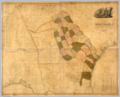
[Early, Eleazer, Sturges, Daniel]
Full Title
Map Of The State of Georgia Prepared from actual Surveys and other Documents for Eleazer Early By Daniel Sturges. Entered According to Act of Congress by Eleazer Early Proprietor. Engraved by Saml. Harrison 1818. Published & Sold By Eleazer Early Savannah Georgia and By John Melish & Samuel Harrison Philadelphia.
List No
4874.000
Note
Ristow mentions two editions with the same title, date and imprint, and with the later edition having "a number of changes and additions... in the southern Alabama portion of the map." We believe this copy is the first edition as we can detect no plate changes in the areas mentioned. This is the first large scale map of Georgia and it ranks in importance with the other large Southern State and Territory maps of the period: Wilson's South Carolina of 1822, Madison's Virginia of 1807 and 1818, Price and Strothers' North Carolina of 1808, and Vignoles' Florida of 1823. While it was undoubtedly the most accurate Georgia map when published, it quickly came under criticism by Tanner in his Geographical Memoir of 1823 for his American Atlas - he found the delineation of the Savannah River to be more correct in the Wilson 1822 Map of South Carolina. It has a lovely cartouche vignette, a table of distances, a statistical table, and "Remarks, Statistical and Geological." Streeter: "All in all an important and elaborate map of Georgia in the first part of the nineteenth century." Full color by county, without rollers.
Author
Arrowsmith, Aaron
Full Title
(Composite Map of) Map of the Island of Japan, Kurile &c. with the Adjacent Coasts of the Chinese Dominions and a Sketch of the River Amoor and the Baikal Lake Including the Trading Posts of Russia and China and their relative situations with Peking. Delineated by A. Arrowsmith 1811. London, Published by A. Arrowsmith, No. 10 Soho Square, Hydrographer to H.R.H. the Prince of Wales, 4th January, 1811. Additions to 1818.
List No
6733.003
Note
"Large and detailed map of Japan and the northeast coast of Asia.This map is a fine example of Arrowsmith's relentless updating of his maps. First issued in 1811, the map shows the tracks of some of the most important naval expeditions of the late eighteenth and early nineteenth century, which charted the waters around Japan, Korea, North East China, and Russia's Pacific coast. These include those made by La Perouse (1787); HMS 'Hindostan' which carried Lord George Macartney on his embassy to China; Broughton in HMS 'Providence' (1797); and the "track of the Russian's in 1805" - Admiral Krusenstern, who led the first Russian circumnavigation. For this 1818 edition Arrowsmith has also added the the track of HMS 'Alceste', and HC Ship 'Discovery' which, made several voyages around the Yellow Sea in 1816. Arrowsmith most probably drew upon the surgeon aboard the 'Alceste', John McCloed, and his book 'A narrative of a Voyage to the Yellow Sea' (1818), for the most up-to-date information." (Lyon and Turnbull).
Author
[Pinkerton, Alaskan Boundary Tribunal, Arrowsmith]
Full Title
(Facsimile) British Possessions in North America (portion). From Mr. Arrowsmith's Map of North America. Pinkerton's Modern Atlas. 1818. Alaska Boundary Tribunal, 1903. 8. Photo. Lith. by A. Hoen & Co. Baltimore, MD.
List No
0009.051
Note
Tinted. Relief shown by hachures.
Author
Depot General de la Marine
Full Title
Carte reduite du Grand Ocean compris entre l'Asie et l'Amerique, redigee d'apres les observations les plus recentes et publiee pour le Service des Vaisseaux Francais. Par ordre du Ministre de la Marine, au Depot General des Cartes et Plans de la Marine et des Colonies, en 1797. Corrigee en 1818. (Paris: Depot-general de la Marine, 1828)
List No
0233.002
Note
Engraved map. Emphasizes coastal detail. No. 288. Logo in lower left corner: Depot Gal. de la Marine. Prime meridian: Paris.
Author
[Reymann, Daniel Gottfried, Flemming, Carl]
Full Title
127 Merseburg
List No
10605.175
Note
Date is the latest date in the series. The range of dates of the sheets is 1822 to 1865
Author
Goujon, J
Full Title
Royaume de France divisé en 86 départemens, avec la distance comptée de Paris en lieues de poste aux chefs-lieux de départemens..., comprenant aussi les anciennes provinces / dressée par Hérisson en 1817 ; Ecrit par A. Pelicier, Myriamètres 10 [= 0m ; 030] ; lieues communes de France de 25 au degré 25 ; corrigée... par... J. Goujon. Gravé par B. Tardieu...
List No
10768.000
Note
First issue 1817, this copy corrected to 1818.
Author
Smith, Charles, 1800-1822
Full Title
(Composite text) A list of maps, published by C. Smith, map seller extraordinary to His Royal Highness the Prince Regent, No. 172, Strand. R. watts, Printer ... London.
List No
11164.000
Note
Catalog of maps and atlases in 4 pages, published by Charles Smith. Date estimated.
Author
Zurla, Placido, 1769-1834
Full Title
(Covers to) Sulle antiche mappe idro - geografiche lavorate in Venezia commentario del P. Ab. D. Placido Zurla. In Venezia Nella Tipografia Picotti MDCCCXVIII (1818).
List No
11171.001
Note
An ancient hydro-geographical work in Venice, by Placido Zurla in 96 pages of descriptive text, and three uncolored maps. Including: 1- Abbozzo della mappa dei viaggi di Marco Polo ... 2- Carta Da Navegar De Nicolo et Antonio Zeni Fvrono In Tramontana Lano M.CCC. LXXX. 3- Abbozzo Del Mappamondo Di F: Mauro Camaldolese Cosmografo Incomparabile alla Meta del Sec. XV. Text and maps includes: Marco Polo's travels, map showing his exploration routes in East Asia, also shows northern part of America, Sierra Nevada, etc., voyages of Nicolo and Antonio Zeno in North Atlantic, map showing North Atlantic, Greenland, Iceland and Lapland, etc., and the last map is a circular planisphere map of the world, made by Fra Mauro.
Author
Zurla, Placido, 1769-1834
Full Title
(Title Page to) Sulle antiche mappe idro - geografiche lavorate in Venezia commentario del P. Ab. D. Placido Zurla. In Venezia Nella Tipografia Picotti MDCCCXVIII (1818).
List No
11171.002
Note
An ancient hydro-geographical work in Venice, by Placido Zurla in 96 pages of descriptive text, and three uncolored maps. Including: 1- Abbozzo della mappa dei viaggi di Marco Polo ... 2- Carta Da Navegar De Nicolo et Antonio Zeni Fvrono In Tramontana Lano M.CCC. LXXX. 3- Abbozzo Del Mappamondo Di F: Mauro Camaldolese Cosmografo Incomparabile alla Meta del Sec. XV. Text and maps includes: Marco Polo's travels, map showing his exploration routes in East Asia, also shows northern part of America, Sierra Nevada, etc., voyages of Nicolo and Antonio Zeno in North Atlantic, map showing North Atlantic, Greenland, Iceland and Lapland, etc., and the last map is a circular planisphere map of the world, made by Fra Mauro.
Author
Zurla, Placido, 1769-1834
Full Title
(Composite text) Sulle antiche mappe idro - geografiche lavorate in Venezia commentario del P. Ab. D. Placido Zurla. In Venezia Nella Tipografia Picotti MDCCCXVIII (1818).
List No
11171.003
Note
An ancient hydro-geographical work in Venice, by Placido Zurla in 96 pages of descriptive text, and three uncolored maps. Including: 1- Abbozzo della mappa dei viaggi di Marco Polo ... 2- Carta Da Navegar De Nicolo et Antonio Zeni Fvrono In Tramontana Lano M.CCC. LXXX. 3- Abbozzo Del Mappamondo Di F: Mauro Camaldolese Cosmografo Incomparabile alla Meta del Sec. XV. Text and maps includes: Marco Polo's travels, map showing his exploration routes in East Asia, also shows northern part of America, Sierra Nevada, etc., voyages of Nicolo and Antonio Zeno in North Atlantic, map showing North Atlantic, Greenland, Iceland and Lapland, etc., and the last map is a circular planisphere map of the world, made by Fra Mauro.
Author
Zurla, Placido, 1769-1834
Full Title
Abbozzo della mappa dei viaggi di Marco Polo nella sala dello Scudo del Palazzo ducale di Venezia. (to accompany) Sulle antiche mappe idro - geografiche lavorate in Venezia.
List No
11171.004
Note
Uncolored map. Showing the travels of Marco Polo in East Asia. Map is orientated with south at the top. In the left hand the Northern part of America (Nuova Spagna) with "Terre Incognite d'Antropofagi" (Unknown land of cannibals), "Quiviria", "Sierra Nevada", "Grandes Corrientes", etc. Relief shown pictorially.
Author
[Zurla, Placido, 1769-1834, Niccolo�� Zeno]
Full Title
Carta Da Navegar De Nicolo et Antonio Zeni Fvrono In Tramontana Lano M.CCC.LXXX. (inset). (to accompany) Sulle antiche mappe idro - geografiche lavorate in Venezia.
List No
11171.005
Note
The Zeno map purports to illustrate the voyages of the author's ancestor and his brother at the end of the 14th century, first appeared in Venice in the year 1558 as a part of a small book that contained accounts of voyages in the North Atlantic and westward to the shores of America. It is, however, a fictitious map based upon Olaus Magnus's Carta marina, along with other 16th century maps, and was probably created to give Venice, the author's native city, the credit for discovering America more than a century ahead of Columbus. Estotiland (said to be inhabited by people of European lineage, but having its own language; it is perhaps Labrador) and Drogeo (perhaps Newfoundland) on this map appear to represent the eastern coast of America. Frisland, originally referred to Iceland, but was added along with Iceland on this map. It appeared on subsequent maps for the next hundred years. It may refer to the Faroe Islands. The meridians are marked.
Author
Wilkinson, Robert
Full Title
The World as Peopled by the Descendants of Noah Shewing the Countries Possessed by Shem, Ham & Japhet and their posterity after the confusion of tongues.
List No
1203.005
Author
Wilkinson, Robert
Full Title
Peloponnesus Exhibiting the Travels of Anacharsis between the Years CCC.LXIII & CCC.LVI before Christ (363 BC - 356 BC).
List No
1203.031
Note
Anacharsis was a Scythian "barbarian" philosopher who impressed the Greeks.
Author
Wilkinson, Robert
Full Title
Exhibiting the Travels of Anacharsis between the Years CCC.LXIII & CCC.LVI Before Christ (363 BC - 356 BC).
List No
1203.032
Note
Anacharsis was a Scythian "barbarian" philosopher who impressed the Greeks.
Author
Wilkinson, Robert
Full Title
Romanum Imperium.
List No
1203.052
Author
[Lizars, William Home, 1788-1859, Lizars, Daniel]
Full Title
(Covers to) New Edinburgh general atlas : or a complete collection of maps of the empires, kingdoms and states throughout the world. The maps drawn and engraved by W. & D. Lizars. Published by T. Brown & W. & D. Lizars, Edinburgh.
List No
13230.001
|