|
Author
Lucas, Fielding Jr.
Full Title
Florida. Drawn and Published by F. Lucas Jr., Baltimore. B.T. Welch & Co. (1822)
List No
4866.059
Note
Engraved. Colored by county. Meridians Greenwich and Washington. Swamps, shoals, banks, and rocks shown.
Author
Lucas, Fielding Jr.
Full Title
Mexico. Drawn and Published by F. Lucas Jr., Baltimore. B.T. Welch & Co., Sc. (1822)
List No
4866.060
Note
Engraved. Colored by state. Meridian Greenwich. Relief shown with hachures.
Author
Lucas, Fielding Jr.
Full Title
West Indies. Drawn and Published by F. Lucas Jr., Baltimore. B.T. Welch & Co., Sc. (1822)
List No
4866.061
Note
Engraved. Colored by state. Meridian Greenwich. Relief shown with hachures. Islands color coded by colonial ownership.
Author
Lucas, Fielding Jr.
Full Title
South America. Drawn and Published by F. Lucas Jr., Baltimore. (1822)
List No
4866.062
Note
Engraved. Colored by state. Meridian London. Relief shown with sketches. Islands color coded by colonial ownership.
Author
Lucas, Fielding Jr.
Full Title
Colombia. Drawn and Published by F. Lucas Jr., Baltimore. Young & Delleker, Sc. Philada. (1822)
List No
4866.063
Note
Engraved. Colored by state. Meridians Washington and London. Relief shown with hachures.
Author
Lucas, Fielding Jr.
Full Title
Brazil. Drawn and Published by F. Lucas Jr., Baltimore. Young & Delleker Sc. Philada. (1822)
List No
4866.064
Note
Engraved. Colored by state. Meridians Washington and London. Relief shown with hachures.
Author
Lucas, Fielding Jr.
Full Title
Peru. Drawn and Published by F. Lucas Jr., Baltimore. B.T. Welch & Co., Sc. (1822)
List No
4866.065
Note
Engraved. Colored by state. Meridians Washington and London. Relief shown with hachures.
Author
Lucas, Fielding Jr.
Full Title
United Provinces. Drawn and Published by F. Lucas Jr., Baltimore. B.T. Welch & Co., Sc. (1822)
List No
4866.066
Note
Engraved. Colored by state. Meridians Washington and London. Relief shown with hachures.
Author
Lucas, Fielding Jr.
Full Title
Chili. Drawn and Published by F. Lucas Jr., Baltimore. B.T. Welch & Co., Sc. (1822)
List No
4866.067
Note
Engraved. Colored by state. Meridians Washington and London. Relief shown with hachures.
Author
Varle, Charles P.
Full Title
Map of the United States Partly From New Surveys Dedicated to the Citizens thereof, by their humble servant Chas. Varle Engineer and Geographer 1817. Entered according to Act of Congress. Published by the Author, Baltimore. Engrav'd by J.H. Young Philada. (with) inset Map of North America. (with) inset Physical Sections from "Washington City to Wheeling and from thence to the mouth of Columbia river" and from the "Pacific Ocean to the Gulf of Mexico."
List No
5471.000
Note
This is an important early map of the United States, and one of the earliest maps engraved by J.H. Young. This ranks with the Melish and Lewis maps of 1816, and the Shelton/Kensett map of 1817. Large map dissected into 24 pieces and mounted on linen with silk edging. In outline color on main map and block color on the inset. Physical sections show relief in varying scale. Folds to 29x27 with no cover.
Author
[Kensett, T., Shelton, W.]
Full Title
Shelton & Kensett's Map Of The State Of Indiana. Protracted from manuscript surveys communicated to the publishers By the Honorable Christopher Harrison. Lieut. Govr. of that State, to which are added the surveys of the Illinois Territory By Genl. Mansfield. Engraved by A. Doolittle, New Haven. (with) A Sketch of the existing connection of the State of Indiana and Illinois Territory, with the adjoining States. Entered ... 25th day of Decr. 1817 by Shelton & Kensett.
List No
5522.000
Note
In outline color by county. Shows townships for Indiana and Illinois.
Author
Arrowsmith, Aaron
Full Title
Outlines of the physical and political divisions of South America: (Sheet 1) delineated by A. Arrowsmith, partly from scarce and original documents, published before the year 1806 but principally from manuscript maps & surveys made between the years 1771 and 1806, corrected from accurate astronomical observations to 1810. London, Published 4th January 1811 by A. Arrowsmith, No. 10 Soho Square, Hydrographer to H.R. H. the Prince of Wales. Additions to 1814, 1817. Engraved by Edwd. Jones.
List No
5699.018
Note
Engraved map. Outline hand col. Relief shown by hachures. Sheet 1 of 6. Shows settlements, roads, rivers, Indian tribes, etc.
Author
Arrowsmith, Aaron
Full Title
(Outlines of the physical and political divisions of South America: Sheet 2. Delineated by A. Arrowsmith, partly from scarce and original documents, published before the year 1806 but principally from manuscript maps & surveys made between the years 1771 and 1806, corrected from accurate astronomical observations to 1810) London, Published 4th January 1811 by A. Arrowsmith, No. 10 Soho Square, (Hydrographer to H.R. H. the Prince of Wales. Additions to 1814, 1817. Engraved by Edwd. Jones)
List No
5699.019
Note
Engraved map. Outline hand col. Relief shown by hachures. Sheet 2 of 6. Shows settlements, roads, rivers, Indian tribes, etc.
Author
Arrowsmith, Aaron
Full Title
(Outlines of the physical and political divisions of South America: Sheet 3. Delineated by A. Arrowsmith, partly from scarce and original documents, published before the year 1806 but principally from manuscript maps & surveys made between the years 1771 and 1806, corrected from accurate astronomical observations to 1810) London, Published 4th January 1811 by A. Arrowsmith, No. 10 Soho Square, (Hydrographer to H.R. H. the Prince of Wales. Additions to 1814, 1817. Engraved by Edwd. Jones)
List No
5699.020
Note
Engraved map. Outline hand col. Relief shown by hachures. Sheet 3 of 6. Shows settlements, roads, rivers, Indian tribes, etc.
Author
Arrowsmith, Aaron
Full Title
(Outlines of the physical and political divisions of South America: Sheet 4. Delineated by A. Arrowsmith, partly from scarce and original documents, published before the year 1806 but principally from manuscript maps & surveys made between the years 1771 and 1806, corrected from accurate astronomical observations to 1810) London, Published 4th January 1811 by A. Arrowsmith, No. 10 Soho Square, (Hydrographer to H.R. H. the Prince of Wales. Additions to 1814, 1817. Engraved by Edwd. Jones)
List No
5699.021
Note
Engraved map. Outline hand col. Relief shown by hachures. Sheet 4 of 6. Shows settlements, roads, rivers, Indian tribes, etc.
Author
Arrowsmith, Aaron
Full Title
(Outlines of the physical and political divisions of South America: Sheet 5. Delineated by A. Arrowsmith, partly from scarce and original documents, published before the year 1806 but principally from manuscript maps & surveys made between the years 1771 and 1806, corrected from accurate astronomical observations to 1810) (with Inset map of the Orinoco and Meta rivers). London, Published 4th January 1811 by A. Arrowsmith, No. 10 Soho Square, (Hydrographer to H.R. H. the Prince of Wales. Additions to 1814, 1817. Engraved by Edwd. Jones)
List No
5699.022
Note
Engraved map. Outline hand col. Relief shown by hachures. Sheet 5 of 6. Shows settlements, roads, rivers, Indian tribes, etc. Scale of inset (ca. 1:118,000)
Author
Arrowsmith, Aaron
Full Title
(Outlines of the physical and political divisions of South America: Sheet 6. Delineated by A. Arrowsmith, partly from scarce and original documents, published before the year 1806 but principally from manuscript maps & surveys made between the years 1771 and 1806, corrected from accurate astronomical observations to 1810). London, Published 4th January 1811 by A. Arrowsmith, No. 10 Soho Square, (Hydrographer to H.R. H. the Prince of Wales. Additions to 1814, 1817. Engraved by Edwd. Jones)
List No
5699.023
Note
Engraved map. Outline hand col. Relief shown by hachures. Sheet 6 of 6. Shows settlements, roads, rivers, Indian tribes, etc. Patagonia, Tierra del Fuego and the Falkland Islands are in inset map.
Author
Arrowsmith, Aaron
Full Title
(Composite of) Outlines of the physical and political divisions of South America: delineated by A. Arrowsmith, partly from scarce and original documents, published before the year 1806 but principally from manuscript maps & surveys made between the years 1771 and 1806, corrected from accurate astronomical observations to 1810. (with Inset map of the Orinoco and Meta rivers). London, Published 4th January 1811 by A. Arrowsmith, No. 10 Soho Square, Hydrographer to H.R. H. the Prince of Wales. Additions to 1814, 1817. Engraved by Edwd. Jones.
List No
5699.024
Note
Engraved map. Outline hand col. Relief shown by hachures. Shows settlements, roads, rivers, Indian tribes, etc.
Author
Arrowsmith, Aaron
Full Title
(Covers to) A New General Atlas, Constructed from the latest Authorities, By A. Arrowsmith, Hydrographer to the Prince Regent, Exhibiting The Boundaries And Divisions, Also The Chains of Mountains and other Geographical Features Of All The Known Countries In The World; Comprehended In Fifty Three Maps From Original Drawings. Edinburgh, Published, 1817 by A. Constable & Co. And By Longman & Compy., London. (title page only) Hy. Corbould delt. Chas. Heath sculpt. Sidy. Hall script. Bury Stt. Bloomsby.
List No
5960.001
Note
First edition of Arrowsmith atlas published in 1817. Although the maps are not large, they are dense with information. This complete atlas features index and 53 copperplate maps, drawn by Arrowsmith and engraved by Sidney Hall, with a few engraved by Thomson in collaboration with Hall. The maps include two world, 29 related to Europe and Scandinavia, 16 on Asia, Africa, and Oceania, and six related to the Americas. The United States map shows Georgia extending from the coast to the Mississippi River. The area west of the Mississippi is blank and labeled Louisiana. Engraved title page has Atlas holding the globe above two putti, one sailing a dingy, the other engaged in cartographic studies with a globe, map and dividers. Hardbound with marbled paper and original paper label printed with "Arrowsmith's New General Atlas Comprehended in Fifty three Maps From Original Drawings. Price L 2,12,6. coloured". Black leather spine has a label embossed with "Atlas (18)17" in gilt. Maps have original outline color, with many tissue guards still in place.
Author
Arrowsmith, Aaron
Full Title
(Title page to) A New General Atlas, Constructed from the latest Authorities, By A. Arrowsmith, Hydrographer to the Prince Regent, Exhibiting The Boundaries And Divisions, Also The Chains of Mountains and other Geographical Features Of All The Known Countries In The World; Comprehended In Fifty Three Maps From Original Drawings. Edinburgh, Published, 1817 by A. Constable & Co. And By Longman & Compy., London. (title page only) Hy. Corbould delt. Chas. Heath sculpt. Sidy. Hall script. Bury Stt. Bloomsby.
List No
5960.002
Note
First edition of Arrowsmith atlas published in 1817. Although the maps are not large, they are dense with information. This complete atlas features index and 53 copperplate maps, drawn by Arrowsmith and engraved by Sidney Hall, with a few engraved by Thomson in collaboration with Hall. The maps include two world, 29 related to Europe and Scandinavia, 16 on Asia, Africa, and Oceania, and six related to the Americas. The United States map shows Georgia extending from the coast to the Mississippi River. The area west of the Mississippi is blank and labeled Louisiana. Engraved title page has Atlas holding the globe above two putti, one sailing a dingy, the other engaged in cartographic studies with a globe, map and dividers. Hardbound with marbled paper and original paper label printed with "Arrowsmith's New General Atlas Comprehended in Fifty three Maps From Original Drawings. Price L 2,12,6. coloured". Black leather spine has a label embossed with "Atlas (18)17" in gilt. Maps have original outline color, with many tissue guards still in place.
Author
Arrowsmith, Aaron
Full Title
(Index page to) A New General Atlas, Constructed from the latest Authorities, By A. Arrowsmith, Hydrographer to the Prince Regent, Exhibiting The Boundaries And Divisions, Also The Chains of Mountains and other Geographical Features Of All The Known Countries In The World; Comprehended In Fifty Three Maps From Original Drawings. Edinburgh, Published, 1817 by A. Constable & Co. And By Longman & Compy., London. (title page only) Hy. Corbould delt. Chas. Heath sculpt. Sidy. Hall script. Bury Stt. Bloomsby.
List No
5960.003
Note
First edition of Arrowsmith atlas published in 1817. Although the maps are not large, they are dense with information. This complete atlas features index and 53 copperplate maps, drawn by Arrowsmith and engraved by Sidney Hall, with a few engraved by Thomson in collaboration with Hall. The maps include two world, 29 related to Europe and Scandinavia, 16 on Asia, Africa, and Oceania, and six related to the Americas. The United States map shows Georgia extending from the coast to the Mississippi River. The area west of the Mississippi is blank and labeled Louisiana. Engraved title page has Atlas holding the globe above two putti, one sailing a dingy, the other engaged in cartographic studies with a globe, map and dividers. Hardbound with marbled paper and original paper label printed with "Arrowsmith's New General Atlas Comprehended in Fifty three Maps From Original Drawings. Price L 2,12,6. coloured". Black leather spine has a label embossed with "Atlas (18)17" in gilt. Maps have original outline color, with many tissue guards still in place.
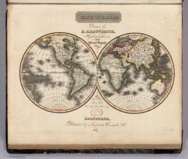
Author
Arrowsmith, Aaron
Full Title
The World. Drawn by A. Arrowsmith, Hydrographer to the Prince Regent. Engraved by Sidney Hall, No. 14 Bury Street, Bloomsby. Edinburgh, Published by Archibald. Constable & Co. 1817.
List No
5960.004
Note
First edition of Arrowsmith atlas published in 1817. Although the maps are not large, they are dense with information. This complete atlas features index and 53 copperplate maps, drawn by Arrowsmith and engraved by Sidney Hall, with a few engraved by Thomson in collaboration with Hall. The maps include two world, 29 related to Europe and Scandinavia, 16 on Asia, Africa, and Oceania, and six related to the Americas. The United States map shows Georgia extending from the coast to the Mississippi River. The area west of the Mississippi is blank and labeled Louisiana. Engraved title page has Atlas holding the globe above two putti, one sailing a dingy, the other engaged in cartographic studies with a globe, map and dividers. Hardbound with marbled paper and original paper label printed with "Arrowsmith's New General Atlas Comprehended in Fifty three Maps From Original Drawings. Price L 2,12,6. coloured". Black leather spine has a label embossed with "Atlas (18)17" in gilt. Maps have original outline color, with many tissue guards still in place.
Author
Arrowsmith, Aaron
Full Title
The World on Mercator's Projection. Drawn by A. Arrowsmith. Engraved by Sidy. Hall. Published, 1817, by A. Constable & Co. Edinburgh.
List No
5960.005
Note
First edition of Arrowsmith atlas published in 1817. Although the maps are not large, they are dense with information. This complete atlas features index and 53 copperplate maps, drawn by Arrowsmith and engraved by Sidney Hall, with a few engraved by Thomson in collaboration with Hall. The maps include two world, 29 related to Europe and Scandinavia, 16 on Asia, Africa, and Oceania, and six related to the Americas. The United States map shows Georgia extending from the coast to the Mississippi River. The area west of the Mississippi is blank and labeled Louisiana. Engraved title page has Atlas holding the globe above two putti, one sailing a dingy, the other engaged in cartographic studies with a globe, map and dividers. Hardbound with marbled paper and original paper label printed with "Arrowsmith's New General Atlas Comprehended in Fifty three Maps From Original Drawings. Price L 2,12,6. coloured". Black leather spine has a label embossed with "Atlas (18)17" in gilt. Maps have original outline color, with many tissue guards still in place.
Author
Arrowsmith, Aaron
Full Title
Europe. Drawn by A. Arrowsmith. Engraved by Sy. Hall, 14 Bury Stt. Bloomsby. Published, 1817, by A. Constable & Co. Edinburgh.
List No
5960.006
Note
First edition of Arrowsmith atlas published in 1817. Although the maps are not large, they are dense with information. This complete atlas features index and 53 copperplate maps, drawn by Arrowsmith and engraved by Sidney Hall, with a few engraved by Thomson in collaboration with Hall. The maps include two world, 29 related to Europe and Scandinavia, 16 on Asia, Africa, and Oceania, and six related to the Americas. The United States map shows Georgia extending from the coast to the Mississippi River. The area west of the Mississippi is blank and labeled Louisiana. Engraved title page has Atlas holding the globe above two putti, one sailing a dingy, the other engaged in cartographic studies with a globe, map and dividers. Hardbound with marbled paper and original paper label printed with "Arrowsmith's New General Atlas Comprehended in Fifty three Maps From Original Drawings. Price L 2,12,6. coloured". Black leather spine has a label embossed with "Atlas (18)17" in gilt. Maps have original outline color, with many tissue guards still in place.
Author
Arrowsmith, Aaron
Full Title
British Islands. Drawn by A. Arrowsmith. Engraved by Sy. Hal,. 14 Bury Stt. Bloomsby. Published, 1817, by A. Constable & Co. Edinburgh.
List No
5960.007
Note
First edition of Arrowsmith atlas published in 1817. Although the maps are not large, they are dense with information. This complete atlas features index and 53 copperplate maps, drawn by Arrowsmith and engraved by Sidney Hall, with a few engraved by Thomson in collaboration with Hall. The maps include two world, 29 related to Europe and Scandinavia, 16 on Asia, Africa, and Oceania, and six related to the Americas. The United States map shows Georgia extending from the coast to the Mississippi River. The area west of the Mississippi is blank and labeled Louisiana. Engraved title page has Atlas holding the globe above two putti, one sailing a dingy, the other engaged in cartographic studies with a globe, map and dividers. Hardbound with marbled paper and original paper label printed with "Arrowsmith's New General Atlas Comprehended in Fifty three Maps From Original Drawings. Price L 2,12,6. coloured". Black leather spine has a label embossed with "Atlas (18)17" in gilt. Maps have original outline color, with many tissue guards still in place.
Author
Arrowsmith, Aaron
Full Title
England. Drawn by A. Arrowsmith. Engraved by S. Hall, 14 Bury Stt. Bloomsby. Published, 1817, by Constable & Co. Edinburgh and Longman & Compy. London.
List No
5960.008
Note
First edition of Arrowsmith atlas published in 1817. Although the maps are not large, they are dense with information. This complete atlas features index and 53 copperplate maps, drawn by Arrowsmith and engraved by Sidney Hall, with a few engraved by Thomson in collaboration with Hall. The maps include two world, 29 related to Europe and Scandinavia, 16 on Asia, Africa, and Oceania, and six related to the Americas. The United States map shows Georgia extending from the coast to the Mississippi River. The area west of the Mississippi is blank and labeled Louisiana. Engraved title page has Atlas holding the globe above two putti, one sailing a dingy, the other engaged in cartographic studies with a globe, map and dividers. Hardbound with marbled paper and original paper label printed with "Arrowsmith's New General Atlas Comprehended in Fifty three Maps From Original Drawings. Price L 2,12,6. coloured". Black leather spine has a label embossed with "Atlas (18)17" in gilt. Maps have original outline color, with many tissue guards still in place.
Author
Arrowsmith, Aaron
Full Title
Scotland. Drawn by A. Arrowsmith. Engraved by Sy. Hall. 14 Bury Stt. Bloomsby. Published, 1817, by A. Constable & Co. Edinburgh.
List No
5960.009
Note
First edition of Arrowsmith atlas published in 1817. Although the maps are not large, they are dense with information. This complete atlas features index and 53 copperplate maps, drawn by Arrowsmith and engraved by Sidney Hall, with a few engraved by Thomson in collaboration with Hall. The maps include two world, 29 related to Europe and Scandinavia, 16 on Asia, Africa, and Oceania, and six related to the Americas. The United States map shows Georgia extending from the coast to the Mississippi River. The area west of the Mississippi is blank and labeled Louisiana. Engraved title page has Atlas holding the globe above two putti, one sailing a dingy, the other engaged in cartographic studies with a globe, map and dividers. Hardbound with marbled paper and original paper label printed with "Arrowsmith's New General Atlas Comprehended in Fifty three Maps From Original Drawings. Price L 2,12,6. coloured". Black leather spine has a label embossed with "Atlas (18)17" in gilt. Maps have original outline color, with many tissue guards still in place.
Author
Arrowsmith, Aaron
Full Title
Ireland. Drawn by A. Arrowsmith. Engraved by Sy. Hall,14 Bury Stt. Bloomsby. Published, 1817, by A. Constable & Co. Edinburgh.
List No
5960.010
Note
First edition of Arrowsmith atlas published in 1817. Although the maps are not large, they are dense with information. This complete atlas features index and 53 copperplate maps, drawn by Arrowsmith and engraved by Sidney Hall, with a few engraved by Thomson in collaboration with Hall. The maps include two world, 29 related to Europe and Scandinavia, 16 on Asia, Africa, and Oceania, and six related to the Americas. The United States map shows Georgia extending from the coast to the Mississippi River. The area west of the Mississippi is blank and labeled Louisiana. Engraved title page has Atlas holding the globe above two putti, one sailing a dingy, the other engaged in cartographic studies with a globe, map and dividers. Hardbound with marbled paper and original paper label printed with "Arrowsmith's New General Atlas Comprehended in Fifty three Maps From Original Drawings. Price L 2,12,6. coloured". Black leather spine has a label embossed with "Atlas (18)17" in gilt. Maps have original outline color, with many tissue guards still in place.
Author
Arrowsmith, Aaron
Full Title
Orkney and Shetland Islands. Drawn by A. Arrowsmith. Engraved by Sidy. Hall. Published, 1817, by A. Constable & Co. Edinburgh. (inset maps) Jersey, Guernsey, &c. and Scilly Islands.
List No
5960.011
Note
First edition of Arrowsmith atlas published in 1817. Although the maps are not large, they are dense with information. This complete atlas features index and 53 copperplate maps, drawn by Arrowsmith and engraved by Sidney Hall, with a few engraved by Thomson in collaboration with Hall. The maps include two world, 29 related to Europe and Scandinavia, 16 on Asia, Africa, and Oceania, and six related to the Americas. The United States map shows Georgia extending from the coast to the Mississippi River. The area west of the Mississippi is blank and labeled Louisiana. Engraved title page has Atlas holding the globe above two putti, one sailing a dingy, the other engaged in cartographic studies with a globe, map and dividers. Hardbound with marbled paper and original paper label printed with "Arrowsmith's New General Atlas Comprehended in Fifty three Maps From Original Drawings. Price L 2,12,6. coloured". Black leather spine has a label embossed with "Atlas (18)17" in gilt. Maps have original outline color, with many tissue guards still in place.
Author
Arrowsmith, Aaron
Full Title
France, N.W. Part. Drawn by A. Arrowsmith. Engraved by Sidy. Hall. Published, 1817, by A. Constable & Co. Edinburgh.
List No
5960.012
Note
First edition of Arrowsmith atlas published in 1817. Although the maps are not large, they are dense with information. This complete atlas features index and 53 copperplate maps, drawn by Arrowsmith and engraved by Sidney Hall, with a few engraved by Thomson in collaboration with Hall. The maps include two world, 29 related to Europe and Scandinavia, 16 on Asia, Africa, and Oceania, and six related to the Americas. The United States map shows Georgia extending from the coast to the Mississippi River. The area west of the Mississippi is blank and labeled Louisiana. Engraved title page has Atlas holding the globe above two putti, one sailing a dingy, the other engaged in cartographic studies with a globe, map and dividers. Hardbound with marbled paper and original paper label printed with "Arrowsmith's New General Atlas Comprehended in Fifty three Maps From Original Drawings. Price L 2,12,6. coloured". Black leather spine has a label embossed with "Atlas (18)17" in gilt. Maps have original outline color, with many tissue guards still in place.
Author
Arrowsmith, Aaron
Full Title
France, N.E. Part. Drawn by A. Arrowsmith. Engraved by Sidy. Hall. Published, 1817, by A. Constable & Co. Edinburgh.
List No
5960.013
Note
First edition of Arrowsmith atlas published in 1817. Although the maps are not large, they are dense with information. This complete atlas features index and 53 copperplate maps, drawn by Arrowsmith and engraved by Sidney Hall, with a few engraved by Thomson in collaboration with Hall. The maps include two world, 29 related to Europe and Scandinavia, 16 on Asia, Africa, and Oceania, and six related to the Americas. The United States map shows Georgia extending from the coast to the Mississippi River. The area west of the Mississippi is blank and labeled Louisiana. Engraved title page has Atlas holding the globe above two putti, one sailing a dingy, the other engaged in cartographic studies with a globe, map and dividers. Hardbound with marbled paper and original paper label printed with "Arrowsmith's New General Atlas Comprehended in Fifty three Maps From Original Drawings. Price L 2,12,6. coloured". Black leather spine has a label embossed with "Atlas (18)17" in gilt. Maps have original outline color, with many tissue guards still in place.
Author
Arrowsmith, Aaron
Full Title
France, S.W. Part. Drawn by A. Arrowsmith. Engraved by Sidy. Hall, 14 Bury Stt. Bloomsby. Published, 1817, by A. Constable & Co. Edinburgh.
List No
5960.014
Note
First edition of Arrowsmith atlas published in 1817. Although the maps are not large, they are dense with information. This complete atlas features index and 53 copperplate maps, drawn by Arrowsmith and engraved by Sidney Hall, with a few engraved by Thomson in collaboration with Hall. The maps include two world, 29 related to Europe and Scandinavia, 16 on Asia, Africa, and Oceania, and six related to the Americas. The United States map shows Georgia extending from the coast to the Mississippi River. The area west of the Mississippi is blank and labeled Louisiana. Engraved title page has Atlas holding the globe above two putti, one sailing a dingy, the other engaged in cartographic studies with a globe, map and dividers. Hardbound with marbled paper and original paper label printed with "Arrowsmith's New General Atlas Comprehended in Fifty three Maps From Original Drawings. Price L 2,12,6. coloured". Black leather spine has a label embossed with "Atlas (18)17" in gilt. Maps have original outline color, with many tissue guards still in place.
Author
Arrowsmith, Aaron
Full Title
France, S.E. Part. Drawn by A. Arrowsmith. Engraved by Sidy. Hall, 14 Bury Stt. Bloomsby. Published, 1817, by A. Constable & Co. Edinburgh.
List No
5960.015
Note
First edition of Arrowsmith atlas published in 1817. Although the maps are not large, they are dense with information. This complete atlas features index and 53 copperplate maps, drawn by Arrowsmith and engraved by Sidney Hall, with a few engraved by Thomson in collaboration with Hall. The maps include two world, 29 related to Europe and Scandinavia, 16 on Asia, Africa, and Oceania, and six related to the Americas. The United States map shows Georgia extending from the coast to the Mississippi River. The area west of the Mississippi is blank and labeled Louisiana. Engraved title page has Atlas holding the globe above two putti, one sailing a dingy, the other engaged in cartographic studies with a globe, map and dividers. Hardbound with marbled paper and original paper label printed with "Arrowsmith's New General Atlas Comprehended in Fifty three Maps From Original Drawings. Price L 2,12,6. coloured". Black leather spine has a label embossed with "Atlas (18)17" in gilt. Maps have original outline color, with many tissue guards still in place.
Author
Arrowsmith, Aaron
Full Title
(Composite of) France
List No
5960.057
Note
Composite of the four sheet maps of France.
Author
Arrowsmith, Aaron
Full Title
Germany, N.W. Part. Drawn by A. Arrowsmith. Engraved by Sy. Hall, 14 Bury Stt. Bloomsby. Published, 1817, by A. Constable & Co. Edinburgh.
List No
5960.016
Note
First edition of Arrowsmith atlas published in 1817. Although the maps are not large, they are dense with information. This complete atlas features index and 53 copperplate maps, drawn by Arrowsmith and engraved by Sidney Hall, with a few engraved by Thomson in collaboration with Hall. The maps include two world, 29 related to Europe and Scandinavia, 16 on Asia, Africa, and Oceania, and six related to the Americas. The United States map shows Georgia extending from the coast to the Mississippi River. The area west of the Mississippi is blank and labeled Louisiana. Engraved title page has Atlas holding the globe above two putti, one sailing a dingy, the other engaged in cartographic studies with a globe, map and dividers. Hardbound with marbled paper and original paper label printed with "Arrowsmith's New General Atlas Comprehended in Fifty three Maps From Original Drawings. Price L 2,12,6. coloured". Black leather spine has a label embossed with "Atlas (18)17" in gilt. Maps have original outline color, with many tissue guards still in place.
Author
Arrowsmith, Aaron
Full Title
Germany, N.E. Part. Drawn by A. Arrowsmith. Engraved by Sy. Hall, 14 Bury Stt. Bloomsby. Published, 1817, by A. Constable & Co. Edinburgh.
List No
5960.017
Note
First edition of Arrowsmith atlas published in 1817. Although the maps are not large, they are dense with information. This complete atlas features index and 53 copperplate maps, drawn by Arrowsmith and engraved by Sidney Hall, with a few engraved by Thomson in collaboration with Hall. The maps include two world, 29 related to Europe and Scandinavia, 16 on Asia, Africa, and Oceania, and six related to the Americas. The United States map shows Georgia extending from the coast to the Mississippi River. The area west of the Mississippi is blank and labeled Louisiana. Engraved title page has Atlas holding the globe above two putti, one sailing a dingy, the other engaged in cartographic studies with a globe, map and dividers. Hardbound with marbled paper and original paper label printed with "Arrowsmith's New General Atlas Comprehended in Fifty three Maps From Original Drawings. Price L 2,12,6. coloured". Black leather spine has a label embossed with "Atlas (18)17" in gilt. Maps have original outline color, with many tissue guards still in place.
Author
Arrowsmith, Aaron
Full Title
Germany, S.W. Part. Drawn by A. Arrowsmith. Engraved by Sy. Hall, 14 Burry Stt. Bloomsby. Published, 1817, by A. Constable & Co. Edinburgh.
List No
5960.018
Note
First edition of Arrowsmith atlas published in 1817. Although the maps are not large, they are dense with information. This complete atlas features index and 53 copperplate maps, drawn by Arrowsmith and engraved by Sidney Hall, with a few engraved by Thomson in collaboration with Hall. The maps include two world, 29 related to Europe and Scandinavia, 16 on Asia, Africa, and Oceania, and six related to the Americas. The United States map shows Georgia extending from the coast to the Mississippi River. The area west of the Mississippi is blank and labeled Louisiana. Engraved title page has Atlas holding the globe above two putti, one sailing a dingy, the other engaged in cartographic studies with a globe, map and dividers. Hardbound with marbled paper and original paper label printed with "Arrowsmith's New General Atlas Comprehended in Fifty three Maps From Original Drawings. Price L 2,12,6. coloured". Black leather spine has a label embossed with "Atlas (18)17" in gilt. Maps have original outline color, with many tissue guards still in place.
Author
Arrowsmith, Aaron
Full Title
Germany, S.E. Part. Drawn by A. Arrowsmith. Engraved by Sy. Hall. 14 Bury Stt. Bloomsby. Published, 1817, by A. Constable & Co. Edinburgh.
List No
5960.019
Note
First edition of Arrowsmith atlas published in 1817. Although the maps are not large, they are dense with information. This complete atlas features index and 53 copperplate maps, drawn by Arrowsmith and engraved by Sidney Hall, with a few engraved by Thomson in collaboration with Hall. The maps include two world, 29 related to Europe and Scandinavia, 16 on Asia, Africa, and Oceania, and six related to the Americas. The United States map shows Georgia extending from the coast to the Mississippi River. The area west of the Mississippi is blank and labeled Louisiana. Engraved title page has Atlas holding the globe above two putti, one sailing a dingy, the other engaged in cartographic studies with a globe, map and dividers. Hardbound with marbled paper and original paper label printed with "Arrowsmith's New General Atlas Comprehended in Fifty three Maps From Original Drawings. Price L 2,12,6. coloured". Black leather spine has a label embossed with "Atlas (18)17" in gilt. Maps have original outline color, with many tissue guards still in place.
Author
Arrowsmith, Aaron
Full Title
(Composite of) Germany
List No
5960.058
Note
A composite of the four sheet maps of Germany
Author
Arrowsmith, Aaron
Full Title
Italy, North Part. Drawn by A. Arrowsmith. Engraved by Sidy. Hall, 14 Bury Stt. Bloomsby. Published, 1817, by A. Constable & Co. Edinburgh.
List No
5960.020
Note
First edition of Arrowsmith atlas published in 1817. Although the maps are not large, they are dense with information. This complete atlas features index and 53 copperplate maps, drawn by Arrowsmith and engraved by Sidney Hall, with a few engraved by Thomson in collaboration with Hall. The maps include two world, 29 related to Europe and Scandinavia, 16 on Asia, Africa, and Oceania, and six related to the Americas. The United States map shows Georgia extending from the coast to the Mississippi River. The area west of the Mississippi is blank and labeled Louisiana. Engraved title page has Atlas holding the globe above two putti, one sailing a dingy, the other engaged in cartographic studies with a globe, map and dividers. Hardbound with marbled paper and original paper label printed with "Arrowsmith's New General Atlas Comprehended in Fifty three Maps From Original Drawings. Price L 2,12,6. coloured". Black leather spine has a label embossed with "Atlas (18)17" in gilt. Maps have original outline color, with many tissue guards still in place.
Author
Arrowsmith, Aaron
Full Title
Italy, South Part. Drawn by A. Arrowsmith. Engraved by Sy. Hall. 14 Bury Stt. Bloomsby. Published, 1817, by A. Constable & Co. Edinburgh.
List No
5960.021
Note
First edition of Arrowsmith atlas published in 1817. Although the maps are not large, they are dense with information. This complete atlas features index and 53 copperplate maps, drawn by Arrowsmith and engraved by Sidney Hall, with a few engraved by Thomson in collaboration with Hall. The maps include two world, 29 related to Europe and Scandinavia, 16 on Asia, Africa, and Oceania, and six related to the Americas. The United States map shows Georgia extending from the coast to the Mississippi River. The area west of the Mississippi is blank and labeled Louisiana. Engraved title page has Atlas holding the globe above two putti, one sailing a dingy, the other engaged in cartographic studies with a globe, map and dividers. Hardbound with marbled paper and original paper label printed with "Arrowsmith's New General Atlas Comprehended in Fifty three Maps From Original Drawings. Price L 2,12,6. coloured". Black leather spine has a label embossed with "Atlas (18)17" in gilt. Maps have original outline color, with many tissue guards still in place.
Author
Arrowsmith, Aaron
Full Title
(Composite of) Italy
List No
5960.059
Note
Composite of the two sheet maps of Italy.
Author
Arrowsmith, Aaron
Full Title
Russia in Europe. North Part. Drawn by A. Arrowsmith. Engraved by Sidy. Hall. Published, 1817, by A. Constable & Co. Edinburgh.
List No
5960.022
Note
First edition of Arrowsmith atlas published in 1817. Although the maps are not large, they are dense with information. This complete atlas features index and 53 copperplate maps, drawn by Arrowsmith and engraved by Sidney Hall, with a few engraved by Thomson in collaboration with Hall. The maps include two world, 29 related to Europe and Scandinavia, 16 on Asia, Africa, and Oceania, and six related to the Americas. The United States map shows Georgia extending from the coast to the Mississippi River. The area west of the Mississippi is blank and labeled Louisiana. Engraved title page has Atlas holding the globe above two putti, one sailing a dingy, the other engaged in cartographic studies with a globe, map and dividers. Hardbound with marbled paper and original paper label printed with "Arrowsmith's New General Atlas Comprehended in Fifty three Maps From Original Drawings. Price L 2,12,6. coloured". Black leather spine has a label embossed with "Atlas (18)17" in gilt. Maps have original outline color, with many tissue guards still in place.
Author
Arrowsmith, Aaron
Full Title
Russia in Europe. South Part. Drawn by A. Arrowsmith. Engraved by Sidy. Hall. Published, 1817, by A. Constable & Co. Edinburgh and Longman & Compy. London.
List No
5960.023
Note
First edition of Arrowsmith atlas published in 1817. Although the maps are not large, they are dense with information. This complete atlas features index and 53 copperplate maps, drawn by Arrowsmith and engraved by Sidney Hall, with a few engraved by Thomson in collaboration with Hall. The maps include two world, 29 related to Europe and Scandinavia, 16 on Asia, Africa, and Oceania, and six related to the Americas. The United States map shows Georgia extending from the coast to the Mississippi River. The area west of the Mississippi is blank and labeled Louisiana. Engraved title page has Atlas holding the globe above two putti, one sailing a dingy, the other engaged in cartographic studies with a globe, map and dividers. Hardbound with marbled paper and original paper label printed with "Arrowsmith's New General Atlas Comprehended in Fifty three Maps From Original Drawings. Price L 2,12,6. coloured". Black leather spine has a label embossed with "Atlas (18)17" in gilt. Maps have original outline color, with many tissue guards still in place.
Author
Arrowsmith, Aaron
Full Title
(Composite of) Russia in Europe
List No
5960.060
Note
Composite of the two sheets maps of Italy.
Author
Arrowsmith, Aaron
Full Title
Denmark, Sweden and Norway. Drawn by A. Arrowsmith. Engraved by Sy. Hall, 14 Bury Stt. Bloomsby. Published, 1817, by A. Constable & Co. Edinburgh.
List No
5960.024
Note
First edition of Arrowsmith atlas published in 1817. Although the maps are not large, they are dense with information. This complete atlas features index and 53 copperplate maps, drawn by Arrowsmith and engraved by Sidney Hall, with a few engraved by Thomson in collaboration with Hall. The maps include two world, 29 related to Europe and Scandinavia, 16 on Asia, Africa, and Oceania, and six related to the Americas. The United States map shows Georgia extending from the coast to the Mississippi River. The area west of the Mississippi is blank and labeled Louisiana. Engraved title page has Atlas holding the globe above two putti, one sailing a dingy, the other engaged in cartographic studies with a globe, map and dividers. Hardbound with marbled paper and original paper label printed with "Arrowsmith's New General Atlas Comprehended in Fifty three Maps From Original Drawings. Price L 2,12,6. coloured". Black leather spine has a label embossed with "Atlas (18)17" in gilt. Maps have original outline color, with many tissue guards still in place.
Author
Arrowsmith, Aaron
Full Title
Denmark. Drawn by A. Arrowsmith. Engraved by Sidy. Hall. Published, 1817, by A. Constable & Co. Edinburgh.
List No
5960.025
Note
First edition of Arrowsmith atlas published in 1817. Although the maps are not large, they are dense with information. This complete atlas features index and 53 copperplate maps, drawn by Arrowsmith and engraved by Sidney Hall, with a few engraved by Thomson in collaboration with Hall. The maps include two world, 29 related to Europe and Scandinavia, 16 on Asia, Africa, and Oceania, and six related to the Americas. The United States map shows Georgia extending from the coast to the Mississippi River. The area west of the Mississippi is blank and labeled Louisiana. Engraved title page has Atlas holding the globe above two putti, one sailing a dingy, the other engaged in cartographic studies with a globe, map and dividers. Hardbound with marbled paper and original paper label printed with "Arrowsmith's New General Atlas Comprehended in Fifty three Maps From Original Drawings. Price L 2,12,6. coloured". Black leather spine has a label embossed with "Atlas (18)17" in gilt. Maps have original outline color, with many tissue guards still in place.
Author
Arrowsmith, Aaron
Full Title
Spain and Portugal. Drawn by A. Arrowsmith. Engraved by Sidy. Hall. Published, 1817, by A. Constable & Co. Edinburgh.
List No
5960.026
Note
First edition of Arrowsmith atlas published in 1817. Although the maps are not large, they are dense with information. This complete atlas features index and 53 copperplate maps, drawn by Arrowsmith and engraved by Sidney Hall, with a few engraved by Thomson in collaboration with Hall. The maps include two world, 29 related to Europe and Scandinavia, 16 on Asia, Africa, and Oceania, and six related to the Americas. The United States map shows Georgia extending from the coast to the Mississippi River. The area west of the Mississippi is blank and labeled Louisiana. Engraved title page has Atlas holding the globe above two putti, one sailing a dingy, the other engaged in cartographic studies with a globe, map and dividers. Hardbound with marbled paper and original paper label printed with "Arrowsmith's New General Atlas Comprehended in Fifty three Maps From Original Drawings. Price L 2,12,6. coloured". Black leather spine has a label embossed with "Atlas (18)17" in gilt. Maps have original outline color, with many tissue guards still in place.
Author
Arrowsmith, Aaron
Full Title
Holland. Drawn by A. Arrowsmith. Engraved by Sidy. Hall. Published, 1817, by A. Constable & Co. Edinburgh.
List No
5960.027
Note
First edition of Arrowsmith atlas published in 1817. Although the maps are not large, they are dense with information. This complete atlas features index and 53 copperplate maps, drawn by Arrowsmith and engraved by Sidney Hall, with a few engraved by Thomson in collaboration with Hall. The maps include two world, 29 related to Europe and Scandinavia, 16 on Asia, Africa, and Oceania, and six related to the Americas. The United States map shows Georgia extending from the coast to the Mississippi River. The area west of the Mississippi is blank and labeled Louisiana. Engraved title page has Atlas holding the globe above two putti, one sailing a dingy, the other engaged in cartographic studies with a globe, map and dividers. Hardbound with marbled paper and original paper label printed with "Arrowsmith's New General Atlas Comprehended in Fifty three Maps From Original Drawings. Price L 2,12,6. coloured". Black leather spine has a label embossed with "Atlas (18)17" in gilt. Maps have original outline color, with many tissue guards still in place.
Author
Arrowsmith, Aaron
Full Title
Netherlands. Drawn by A. Arrowsmith. Engraved by Sy. Hall. Published, 1817, by A. Constable & Co. Edinburgh, and Longman & Compy. London.
List No
5960.028
Note
First edition of Arrowsmith atlas published in 1817. Although the maps are not large, they are dense with information. This complete atlas features index and 53 copperplate maps, drawn by Arrowsmith and engraved by Sidney Hall, with a few engraved by Thomson in collaboration with Hall. The maps include two world, 29 related to Europe and Scandinavia, 16 on Asia, Africa, and Oceania, and six related to the Americas. The United States map shows Georgia extending from the coast to the Mississippi River. The area west of the Mississippi is blank and labeled Louisiana. Engraved title page has Atlas holding the globe above two putti, one sailing a dingy, the other engaged in cartographic studies with a globe, map and dividers. Hardbound with marbled paper and original paper label printed with "Arrowsmith's New General Atlas Comprehended in Fifty three Maps From Original Drawings. Price L 2,12,6. coloured". Black leather spine has a label embossed with "Atlas (18)17" in gilt. Maps have original outline color, with many tissue guards still in place.
|