|
Author
[Depot General de la Marine, Huddart, Joseph]
Full Title
Carte Particuliere De La Cote Sud-Ouest D'Irlande
List No
15934.085
Note
Hydrographie Française 2
Author
Depot General de la Marine
Full Title
(West Sheet) Carte Particuliere De La Cote Sud-Ouest D'Irlande
List No
15934.086
Note
Hydrographie Française 2
Author
Depot General de la Marine
Full Title
(Composite map of) (West and East Sheets) Carte Particuliere De La Cote Sud-Ouest D'Irlande
List No
15934.087
Note
Hydrographie Française 2
Author
[Depot General de la Marine, Huddart, Joseph]
Full Title
Carte Particuliere De La Cote Ouest D'Irlande depuis Sligo jusqu'a L'Umbouchure du Shannon
List No
15934.088
Note
Hydrographie Française 2
Author
Depot General de la Marine
Full Title
Plan... Little Middlegrund (with) Carte Particuliere... Port de Marstrand (with) Carte... Kongsbacka (with) Plan... Hallands Waederoe (with) Carte... Golfe de Gottembourge
List No
15934.022
Note
Hydrographie Française 1 Five plans on one sheet. Date estimated.
Author
Lapie, M. (Pierre), 1779-1850
Full Title
(Covers to) Carte Des Iles Britannique ou Royaume - Uni De La Grande Bretagne & d'Ireland 2. Edition. 1814
List No
15523.001
Author
Lapie, M. (Pierre), 1779-1850
Full Title
(Sheet 1) Carte Des Iles Britannique ou Royaume - Uni De La Grande Bretagne & d'Ireland 2. Edition. 1814
List No
15523.002
Author
Lapie, M. (Pierre), 1779-1850
Full Title
(Sheet 2) Carte Des Iles Britannique ou Royaume - Uni De La Grande Bretagne & d'Ireland 2. Edition. 1814
List No
15523.003
Author
Lapie, M. (Pierre), 1779-1850
Full Title
(Sheet 3) Carte Des Iles Britannique ou Royaume - Uni De La Grande Bretagne & d'Ireland 2. Edition. 1814
List No
15523.004
Author
Lapie, M. (Pierre), 1779-1850
Full Title
(Sheet 4) Carte Des Iles Britannique ou Royaume - Uni De La Grande Bretagne & d'Ireland 2. Edition. 1814
List No
15523.005
Author
Lapie, M. (Pierre), 1779-1850
Full Title
(Sheet 5) Carte Des Iles Britannique ou Royaume - Uni De La Grande Bretagne & d'Ireland 2. Edition. 1814
List No
15523.006
Author
Lapie, M. (Pierre), 1779-1850
Full Title
(Sheet 6) Carte Des Iles Britannique ou Royaume - Uni De La Grande Bretagne & d'Ireland 2. Edition. 1814
List No
15523.007
Author
Lapie, M. (Pierre), 1779-1850
Full Title
(Composite map to) (Sheets 1-6) Carte Des Iles Britannique ou Royaume - Uni De La Grande Bretagne & d'Ireland 2. Edition. 1814
List No
15523.008
Author
Heather, William, 1764-1812
Full Title
(Covers to) The new Mediterranean Harbour pilot : Containing Two Hundred and Twenty-four Accurate Plans of the Principal Harbours, Bays, Roadsteads, and Islands in the Mediterranean Sea, Including Those in the Gulf of Venice, Archipelago, Sea of Marmora, & the Levant; with addition of a large plan of Cadiz, the Straits of Gibraltar, Bonifacio, &c. drawn from the latest English, French, Spanish, Italian, and Venetian surveys and corrected from the journals and observations of several distinguished navigators. By William Heather. A new edition, Improved by J. W. Norie, Hydrographer, &c. London : Printed for and published by J.W. Norie and Co., 1814.
List No
13404.001
Note
Brown leather covers, with label pasted on front cover, printed with "Mediterranean harbor pilot”.
Author
Heather, William, 1764-1812
Full Title
(Title Page to) The new Mediterranean Harbour pilot : Containing Two Hundred and Twenty-four Accurate Plans of the Principal Harbours, Bays, Roadsteads, and Islands in the Mediterranean Sea, Including Those in the Gulf of Venice, Archipelago, Sea of Marmora, & the Levant; with addition of a large plan of Cadiz, the Straits of Gibraltar, Bonifacio, &c. drawn from the latest English, French, Spanish, Italian, and Venetian surveys and corrected from the journals and observations of several distinguished navigators. By William Heather. A new edition, Improved by J. W. Norie, Hydrographer, &c. London : Printed for and published by J.W. Norie and Co., 1814.
List No
13404.002
Author
Heather, William, 1764-1812
Full Title
(Contents to) The new Mediterranean Harbour pilot : Containing Two Hundred and Twenty-four Accurate Plans of the Principal Harbours, Bays, Roadsteads, and Islands in the Mediterranean Sea, Including Those in the Gulf of Venice, Archipelago, Sea of Marmora, & the Levant; with addition of a large plan of Cadiz, the Straits of Gibraltar, Bonifacio, &c. drawn from the latest English, French, Spanish, Italian, and Venetian surveys and corrected from the journals and observations of several distinguished navigators. By William Heather. A new edition, Improved by J. W. Norie, Hydrographer, &c. London : Printed for and published by J.W. Norie and Co., 1814.
List No
13404.003
Author
Heather, William, 1764-1812
Full Title
A survey of Cadiz harbor. By Don Vincente Tofino. Stephenson engraver. (to accompany) The new Mediterranean Harbour pilot. By William Heather ... London : Printed for and published by J.W. Norie and Co., 1814.
List No
13404.004
Note
Engraved nautical chart of Cadiz. Includes 2 profils: "Appearance of the highland behind Cadiz ..."
Author
Heather, William, 1764-1812
Full Title
The Strait of Gibraltar. By Don Vincente Tofino. Stephenson engraver. (to accompany) The new Mediterranean Harbour pilot. By William Heather ... London : Printed for and published by J.W. Norie and Co., 1814.
List No
13404.005
Note
Engraved nautical chart of Strait of Gibraltar. Includes profile: "Appearance of the land as seen from the Pearl Rock, at the entrance to the Bay of Gibraltar ..."
Author
Heather, William, 1764-1812
Full Title
The Strait of Bonifacio. By M. Thomas Clements. Stephenson engraver. London, Published as the act directs, February 1st. 1809, by William Heather, at the Navigation Warehouse. (to accompany) The new Mediterranean Harbour pilot. By William Heather ... London : Printed for and published by J.W. Norie and Co., 1814.
List No
13404.006
Note
Engraved nautical chart of the Strait of Bonifacio, Corsica.
Author
Heather, William, 1764-1812
Full Title
The coast of Egypt. The passage of Dardanells. By W. Heather.Stephenson engraver. London, Published as the act directs, February 1st. 1809, by William Heather, at the Navigation Warehouse. (to accompany) The new Mediterranean Harbour pilot. By William Heather ...London : Printed for and published by J.W. Norie and Co., 1814.
List No
13404.007
Note
2 engraved nautical chart on 1 plate. Showing the Strait of Dardanelles and Coast of Egypt.
Author
Heather, William, 1764-1812
Full Title
No.1. Gibraltar Bay. No.2. The Bay of Malaga. By Michelot. No. 5. The Bay of Alicant. No. 6. The Port of Yvica, with the channels adjacent. By Vincent Tofino. J. Stephenson, Sc. (to accompany) The new Mediterranean Harbour pilot. By William Heather ... London : Printed for and published by J.W. Norie and Co., 1814.
List No
13404.008
Note
4 engraved nautical charts of the Western Mediterranean on 1 plate. each 15x19. Including: Chart Nos. 1-2, 5-6.
Author
Heather, William, 1764-1812
Full Title
No. 3. The Bay of Almeria. By Michelot. No. 4. The harbor of Carthagena. By Vincente Tofino. No. 7. The Bay of Majorca. By Michelot. No. 8. The Bay of Pollenza and Alcudia. By Vincente Tofino. J. Stephenson, Sc. (to accompany) The new Mediterranean Harbour pilot. By William Heather ... London : Printed for and published by J.W. Norie and Co., 1814.
List No
13404.009
Note
4 engraved nautical charts of Western Mediterranean on 1 plate. each 15x19. Including: Chart Nos. 3-4, 7-8.
Author
Heather, William, 1764-1812
Full Title
No.9. A plan of Port Mahon. By Vin. Tofino. No. 10. A plan of Le Sofa Bay. No. 13. The Bay of Philiou. By Michelot. No. 14. Port Palamos. J. Stephenson, Sc. (to accompany) The new Mediterranean Harbour pilot. By William Heather ... London : Printed for and published by J.W. Norie and Co., 1814.
List No
13404.010
Note
4 engraved nautical charts of Western Mediterranean on 1 plate. each 15x19. Includes inset to chart 9: Entrance to Citadel in Minorca. Including: Chart Nos. 9-1, 14-15.
Author
Heather, William, 1764-1812
Full Title
No.11. The road of Salo. By Ayrouard. No. 12. The Port of Barcelona. By Michelot. No. 15. The Bay of Roses. By Michelot. No. 16. Cadaquie. By Ayrouard. J. Stephenson, Sc. (to accompany) The new Mediterranean Harbour pilot. By William Heather ... London : Printed for and published by J.W. Norie and Co., 1814.
List No
13404.011
Note
4 engraved nautical charts of Western Mediterranean on 1 plate. each 15x19. Including: Chart Nos. 11-12, 15-16.
Author
Heather, William, 1764-1812
Full Title
No.17. Plan of Port Vendre. By Ayrouard. No. 18. The Port of Colioure. By Michelot. No. 21. The Port of Boug. By Ayrouard. No. 22. Bay of Marseilles. By Michelot. J. Stephenson, Sc. (to accompany) The new Mediterranean Harbour pilot. By William Heather ... London : Printed for and published by J.W. Norie and Co., 1814.
List No
13404.012
Note
4 engraved nautical charts of Western Mediterranean on 1 plate. each 15x19. Including: Chart Nos. 17-18, 21-22.
Author
Heather, William, 1764-1812
Full Title
No.19. Port of Agde and fort Brescon. No. 20. The Port of Cette. By Ayrouard. No. 23. The Port of Pormiou from the French. No. 24. Port of Cassis. J. Stephenson, Sc. (to accompany) The new Mediterranean Harbour pilot. By William Heather ... London : Printed for and published by J.W. Norie and Co., 1814.
List No
13404.013
Note
4 engraved nautical charts of Western Mediterranean on 1 plate. each 15x19. Including: Chart Nos. 19-2., 23-24.
Author
Picquet, Charles
Full Title
(Covers to) Plan Routier de la Ville de Paris Divise en XII Arrondissements ou Mairies et en 48 Quartiers, Sur lequel sent indiques tous les Changements & Projets ordennes par le Gouverenement -- Dedie & Presente a Mr. Le Comte Frochot . . . Projet du Departement de la Seine, 1812. . . Corrigee en 1814
List No
10904.001
Note
In a case box with a second map of Paris, our 10905.000
Author
Picquet, Charles
Full Title
Plan Routier de la Ville de Paris Divise en XII Arrondissements ou Mairies et en 48 Quartiers, Sur lequel sent indiques tous les Changements & Projets ordennes par le Gouverenement -- Dedie & Presente a Mr. Le Comte Frochot . . . Projet du Departement de la Seine, 1812. . . Corrigee en 1814
List No
10904.002
Note
In a case box with a second map of Paris, our 10905.000
Author
Flinders, Matthew, 1774-1814
Full Title
(Covers to) Volume I, A Voyage to Terra Australis, undertaken for the purpose of completing the discovery of that vast country, and prosecuted in the years 1801, 1802 and 1803, in His Majesty's Ship the Investigator...
List No
10745.001
Author
[Flinders, Matthew, 1774-1814, Westall, William, 1781-1850]
Full Title
View from the south side of King George's Sound.
List No
10745.002
Note
William Westall was a Royal Academy artist appointed to Matthew Flinders voyage at 19 years of age. His method of drawing topographical views was to rule up his drawing sheets in a grid pattern to obtain an accurate perspective.
Author
Flinders, Matthew, 1774-1814
Full Title
(Title page to) Volume I, A Voyage to Terra Australis, undertaken for the purpose of completing the discovery of that vast country, and prosecuted in the years 1801, 1802 and 1803, in His Majesty's Ship the Investigator...
List No
10745.003
Author
[Flinders, Matthew, 1774-1814, Westall, William, 1781-1850]
Full Title
Entance of Port Lincoln, taken from behind Memory Cove.
List No
10745.008
Note
William Westall was a Royal Academy artist appointed to Matthew Flinders voyage at 19 years of age. His method of drawing topographical views was to rule up his drawing sheets in a grid pattern to obtain an accurate perspective.
Author
[Flinders, Matthew, 1774-1814, Westall, William, 1781-1850]
Full Title
View on the north side of Kanguroo Island.
List No
10745.009
Note
William Westall was a Royal Academy artist appointed to Matthew Flinders voyage at 19 years of age. His method of drawing topographical views was to rule up his drawing sheets in a grid pattern to obtain an accurate perspective.
Author
[Flinders, Matthew, 1774-1814, Westall, William, 1781-1850]
Full Title
View of Port Jackson, taken from the South Head.
List No
10745.010
Note
William Westall was a Royal Academy artist appointed to Matthew Flinders voyage at 19 years of age. His method of drawing topographical views was to rule up his drawing sheets in a grid pattern to obtain an accurate perspective.
Author
[Flinders, Matthew, 1774-1814, Westall, William, 1781-1850]
Full Title
View of Port Bowen, from the hills behind the Watering Gully.
List No
10745.012
Note
William Westall was a Royal Academy artist appointed to Matthew Flinders voyage at 19 years of age. His method of drawing topographical views was to rule up his drawing sheets in a grid pattern to obtain an accurate perspective.
Author
[Flinders, Matthew, 1774-1814, Westall, William, 1781-1850]
Full Title
View of Murray's Islands, with the natives offering to barter.
List No
10745.014
Note
William Westall was a Royal Academy artist appointed to Matthew Flinders voyage at 19 years of age. His method of drawing topographical views was to rule up his drawing sheets in a grid pattern to obtain an accurate perspective.
Author
[Flinders, Matthew, 1774-1814, Westall, William, 1781-1850]
Full Title
View in Sir Edward Pellew's Group; - Gulph of Carpentaria.
List No
10745.015
Note
William Westall was a Royal Academy artist appointed to Matthew Flinders voyage at 19 years of age. His method of drawing topographical views was to rule up his drawing sheets in a grid pattern to obtain an accurate perspective.
Author
[Flinders, Matthew, 1774-1814, Westall, William, 1781-1850]
Full Title
View of Malay Road from Pobassoo's Island.
List No
10745.016
Note
William Westall was a Royal Academy artist appointed to Matthew Flinders voyage at 19 years of age. His method of drawing topographical views was to rule up his drawing sheets in a grid pattern to obtain an accurate perspective.
Author
[Flinders, Matthew, 1774-1814, Westall, William, 1781-1850]
Full Title
View of the Wreck-Reef Bank, taken from low water.
List No
10745.017
Note
William Westall was a Royal Academy artist appointed to Matthew Flinders voyage at 19 years of age. His method of drawing topographical views was to rule up his drawing sheets in a grid pattern to obtain an accurate perspective. "After Flinders' 'Investigator' was condemned as unseaworthy at Sydney in 1803, ending his Australian survey, he embarked with Westall as passengers in HM sloop 'Porpoise' to return to England, in company with the storeship 'Cato' and the Indiaman 'Bridgewater'. They sailed on 10 August 1803 but on the 17th both 'Porpoise' and 'Cato' ran aground 800 miles north of Sydney, on a sandbank subsequently known as Wreck Reef (or Reefs), part of the Great Barrier Reef. Both were quickly holed by coral and the larger 'Cato' broke up. Three men were lost but everyone else escaped onto a nearby dry bank, where they camped as shown in the painting, having salvaged what they could (including many but not all of Westall's drawings). The grounded and dismasted hull of the 'Porpoise' (a Spanish-built packet schooner captured in 1799) can be seen at far left. The 'Bridgewater' sailed on and later reported both ships lost without survivors. After nearly ten days without sign of help, Flinders then sailed back to Sydney in the 'Porpoise's' cutter and returned with the 29-ton schooner 'Cumberland', the schooner 'Frances' and the East Indiaman 'Rolla', which was bound for Canton, to pick people up. The 'Frances' took a few people back to Sydney: the majority, including Westall, went on to China in 'Rolla' as the next stage homeward. He first did some brief work there and then more during three months at Bombay before reaching England again in 1804. Flinders sailed directly from Wreck Reef for England with a selected volunteer crew in the 'Cumberland', but was detained on Mauritius as a prisoner of war for nearly six years after putting in there for repairs, owing to the schooner's leaky condition. Although Flinders had a French passport, this had been made out for 'Investigator', not personally for him and his crew in any other ship, and his high-handed approach to General Decaen, the French governor (who decided to treat him as a spy), was not well calculated to gain co-operative and early release. He only reached England again in October 1810. The image was engraved as one of the plates in Flinders ‘A Voyage to Terra Australis' (1814, and also separately published that year in Westall's 'Views of Australian Scenery'). It is the last plate in vol. 2, illustrating the dated journal text about the incident." (Royal Museums Greenwich catalog ZBA7935)
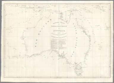
Author
[Flinders, Matthew, 1774-1814, Arrowsmith, John, 1790-1873]
Full Title
General chart of Terra Australis or Australia; showing the parts explored between 1798 and 1803
List No
10745.018
Note
First highly accurate map of Australia, although published 3 years after the Freycinet map of 1811 which is the first map to show the entire Australian coastline in detail.
Author
[Flinders, Matthew, 1774-1814, Arrowsmith, John, 1790-1873]
Full Title
(Composite map of) Plates I-XVI, Chart of Terra Australis.
List No
10745.046
Note
Composite of all 16 charts showing the areas mapped by Flinders, noting that he did not map the northwest coast. All charts shown at the same scale with the coast lines matched to the coast lines of the General Chart, Plate I.
Author
[Flinders, Matthew, 1774-1814, Arrowsmith, John, 1790-1873]
Full Title
Chart of Terra Australis. South Coast, Sheet I.
List No
10745.019
Note
Insets: King Geo. Sound with its harbours. Scale [ca. 1:190 080] Map of the south coast of Western Australia from Cape Leeuwin to Cape Arid showing tracks of Investigator, 1801-1803. Relief shown by hachures and bathymetric soundings. Plate II from atlas: A voyage to Terra Australis / by Matthew Flinders. London : G. and W. Nicol, 1814. Prime meridian: Greenwich. Archipelago of the Recherche. Scale [ca. 1:333 333]
Author
[Flinders, Matthew, 1774-1814, Arrowsmith, John, 1790-1873]
Full Title
Chart of Terra Australis. South Coast, Sheet II.
List No
10745.020
Note
Map of the south coast of Western Australia and part of South Australia from Cape Arid to Head of Bight showing tracks of Investigator, 1802-1803. Relief shown by hachures and bathymetric soundings. Plate III from atlas: A voyage to Terra Australis / by Matthew Flinders. London : G. and W. Nicol, 1814. Prime meridian: Greenwich.
Author
[Arrowsmith, John, 1790-1873, Flinders, Matthew, 1774-1814]
Full Title
Chart of Terra Australis. South Coast, Sheet III.
List No
10745.021
Note
Map of the coast of South Australia from Head of Bight to Encounter Bay showing track of Investigator, 1802. Relief shown by hachures and bathymetric soundings. Insets: Eastern extremity of Nuyts' Land. Nuyts' Archipelago. Scale [ca. 1:500 000] [Port Lincoln]. Scale [ca. 1:250 000] Head of Spencer's Gulf. Scale [ca. 1: 416 666]
Author
[Arrowsmith, John, 1790-1873, Flinders, Matthew, 1774-1814]
Full Title
Chart of Terra Australis. South Coast, Sheet IV.
List No
10745.022
Note
Map of the coast of South Australia and part of Victoria from Cape Bernouilli to Cape Otway showing track of Investigator, 1802. Relief shown by hachures and bathymetric soundings.
Author
[Arrowsmith, John, 1790-1873, Flinders, Matthew, 1774-1814]
Full Title
Chart of Terra Australis. South Coast, Sheet V.
List No
10745.023
Note
Map of Bass Strait and part of New South Wales from Cape Otway to Twofold Bay showing tracks of Investigator, 1798-1803. Relief shown by hachures and bathymetric soundings. Insets: [Port Phillip and Western Port] Twofold Bay Southernmost part of Furneaux's Islands Port Dalrymple discovered 1798, in the Norfolk sloop, by M. Flinders; with additional soundings written at right angles, from Mr. Collins' sketch, 1804.
Author
[Arrowsmith, John, 1790-1873, Flinders, Matthew, 1774-1814]
Full Title
Chart of Terra Australis. South Coast, Sheet VI.
List No
10745.024
Note
Map of Tasmania showing tracks of Norfolk and Francis, 1798-1799. Relief shown by hachures and bathymetric soundings.
Author
[Arrowsmith, John, 1790-1873, Flinders, Matthew, 1774-1814]
Full Title
Chart of Terra Australis. East Coast, Sheet I.
List No
10745.025
Note
Map of the central coast of New South Wales from Barmouth Creek to Cape Hawke showing southward tracks of Francis and Norfolk in 1798, Norfolk's northward track in 1799 and tracks of Investigator in 1802 and 1803. Relief shown by hachures and bathymetric soundings. Insets: Port Hunter, from Mr. Barrallier 1801 Entrance of Broken Bay, from Capt. Hunter 1789 Entrance of Port Jackson, from Capt. Hunter 1788 Entrance of Botany Bay, from Capt. Hunter 1789.
Author
[Arrowsmith, John, 1790-1873, Flinders, Matthew, 1774-1814]
Full Title
Chart of Terra Australis. East Coast, Sheet II.
List No
10745.026
Note
Map of the north coast of New South Wales from Smoky Cape to Moreton Bay in Queensland showing tracks of Norfolk in 1799 and Investigator in 1802. Relief shown by hachures and bathymetric soundings.
Author
[Arrowsmith, John, 1790-1873, Flinders, Matthew, 1774-1814]
Full Title
Chart of Terra Australis. East Coast, Sheet III.
List No
10745.027
Note
Map of the coast of Queensland from Wide Bay to Flat Isles showing tracks of Norfolk in 1799, Investigator in 1802 and Porpoise, Cato, Bridgewater, Cumberland, Rolla and Francis in 1803. Relief shown by hachures and bathymetric soundings.
Author
[Arrowsmith, John, 1790-1873, Flinders, Matthew, 1774-1814]
Full Title
Chart of Terra Australis. East Coast, Sheet IV.
List No
10745.028
Author
[Arrowsmith, John, 1790-1873, Flinders, Matthew, 1774-1814]
Full Title
Chart of Terra Australis. East Coast, Sheet V.
List No
10745.029
Note
Map of the north-east coast of Queensland from Cape Grafton to Cape Flattery showing track of Investigator in 1802 and part of track of Cumberland in 1803. Relief shown by hachures and bathymetric soundings.
Author
[Arrowsmith, John, 1790-1873, Flinders, Matthew, 1774-1814]
Full Title
Chart of Terra Australis. North Coast, Sheet I.
List No
10745.030
Note
Map of Cape York Peninsula, Queensland from Cape Weymouth to Cape York, Torres Strait and sections of the south coast of New Guinea showing tracks of Investigator in 1802 and Cumberland in 1803. Relief shown by hachures and bathymetric soundings. Inset: [Prince of Wales's Is. and Endeavour's Strait]
Author
[Arrowsmith, John, 1790-1873, Flinders, Matthew, 1774-1814]
Full Title
Chart of Terra Australis. North Coast, Sheet II.
List No
10745.031
Note
Map of Gulf of Carpentaria from Endeavour Strait to Arnhem Bay showing tracks of Investigator, 1802-1803 and Cumberland in 1803. Relief shown by hachures and bathymetric soundings. Insets: Gulph [i.e. Gulf] of Carpentaria [Sir Edward Pellew's Group] [Southernmost of Wellesley's Islands]
Author
[Arrowsmith, John, 1790-1873, Flinders, Matthew, 1774-1814]
Full Title
North West Side of the Gulf of Carpentaria.
List No
10745.032
Note
Map of Gulf of Carpentaria from Groote Eylandt to Arnhem Bay showing tracks of Investigator and Cumberland, 1803. Relief shown by hachures and bathymetric soundings.
Author
[Arrowsmith, John, 1790-1873, Flinders, Matthew, 1774-1814]
Full Title
Timor and some of the neighbouring islands.
List No
10745.033
Note
Has information added up to 1814. Hydrographic chart of seas around Timor Is. Relief shown by hachures and depth by bathymetric soundings.
Author
[Flinders, Matthew, 1774-1814, Westall, William, 1781-1850]
Full Title
Views on the South Coast of Terra Australis.
List No
10745.034
Note
14 views on 1 sheet. No. 1. Cape Leeuwin, the south-west extremity of New Holland taken Dec. 7 1801 2. Cape Chatham taken Dec. 8, 1801 3. Eclipse Isles taken Dec. 8, 1801 4. Seal Island in K. George's Sound taken Dec. 9 1801 5. Middle Island in the Archipelago of the Recherche taken May 17, 1803 6. Cliffs, distant 5 or 6 miles taken Jan. 26, 1802 7. Cape Wiles taken Feb. 19, 1802 8, Cape Catastrophe taken Feb. 20 1802... 9. Thistle's Island : taken from the [anchorage] in Memory Cove Feb. 24 1802 10. Mountains at the head of Spencer's Gulph taken from the [anchorage] March 12 1802 11. Part of Kanguroo Island taken April 6, 1802 12. Cape Jervis taken from the [anchorage] near Kanguroo [i.e. Kangaroo] Head, April 6 1802 13. Entrance of Port Phillip, taken May 3 1802 14. Cape Schanck, taken May 3 1802. Westall was a Royal Academy artist appointed to Mathew Flinders voyage at 19 years of age. His method of drawing topographical views was to rule up his drawing sheets in a grid pattern to obtain an accurate perspective.
Author
[Flinders, Matthew, 1774-1814, Westall, William, 1781-1850]
Full Title
Views on the East Coast of Terra Australis ; Views on the East and North coasts of Terra Australis.
List No
10745.035
Note
14 views on 1 sheet. No. 1. Entrance of Port Jackson taken May 9, 1802 No. 2. Entrance of Broken Bay taken July 22, 1802 No. 3. View from near Cape Byron taken July 25, 1802 No. 4. Part of the great Sandy Peninsula taken July 28, 1802 No. 5 View from the entrance of Keppel Bay taken Aug. 17, 1802 No. 6. Cape Manifold taken Aug. 19, 1802 No. 7. Part of Harvey's Isles taken Aug. 21, 1802 No. 8. Cape Clinton taken Aug. 23, 1802 No. 9. Land on the north side of Port Bowen taken Aug. 24, 1802 No. 10. Murray's Isles in Torres Strait taken Oct. 29, 1802 No. 11. Murray's Isles taken Oct. 30, 1802 No. 12. North eastern part of the Prince of Wales' Islands taken Oct. 31, 1802 No. 13. Land on the north side of Blue-mud Bay taken Jan. 29, 1803 [No. 14]. Samow Strait taken from the north point of Rottee taken March 30, 1803. Westall was a Royal Academy artist appointed to Mathew Flinders voyage at 19 years of age. His method of drawing topographical views was to rule up his drawing sheets in a grid pattern to obtain an accurate perspective.
Author
Anonymous
Full Title
Nouveau plan de Paris et ses environs.
List No
10281.000
Note
Rare hemispherical map, made for the game called "Compass Game." The borders of the circle contain boxes of two colors containing the names of the 12 boroughs of Paris at the time, as well as a compass divided into 32 tunes of winds. The four corners are decorated with cherubs. Beautiful copy with fine original watercolor.
Author
Arrowsmith, Aaron
Full Title
(Composite Map) Chart of the Pacific Ocean ... (Australia, Philippines, China, etc.) London: Published October 1st. 1798, by A. Arrowsmith.
List No
13258.003
Note
Sheets 4 and 7 from the 9 sheet chart of the Pacific, published in 1814, by Aaron Arrowsmith. The 9 sheet chart first published in 1798 and reissued over many years. These 2 sheets cover north to south from the coast of China to the Philippines, the East Indies, Australia and a portion of New Zealand. Showing coastal outlines, the important recent discoveries around Philippines and Australia, with detailed notes on history of exploration and European colonization in the area. Includes compass roses. Depth shown by soundings. The 1814 maps of the coastal explorations by Matthew Flinders were made by Arrowsmith's nephew, John Arrowsmith, and provided the new coastal features that Arrowmith incorporated into these maps.
Author
[Humboldt, Alexander von, 1769-1859, Bonpland, Aime]
Full Title
(Title Page) Voyage de Humboldt et Bonpland. Premiere Partie, Relation Historique. Atlas Geographique et Physique de Nouveau Continent. A Paris, Chez F. Schoell, Libraire, Rue des Fosses-Montmartre, No. 14. 1814.
List No
12125.013
Author
Arrowsmith, Aaron
Full Title
(Covers to) A Map Exhibiting all the New Discoveries in the Interior Parts of North America Inscribed by Permission To the Honorable Governor And Company Of Adventurers Of England Trading Into Hudson Bay In testimony of their liberal Communications To their most Obedient and very Humble Servant, A. Arrowsmith, Hydrographer to H.R.H. the Prince of Wales. No. 10 Soho Square, January 1st 1795. Additions to 1811. Additions to 1814. London: Published Jan. 1, 1795 by A. Arrowsmith No. 10 Soho Square. Additions to 1802 ...
List No
0032A
Author
Arrowsmith, Aaron
Full Title
A Map Exhibiting all the New Discoveries in the Interior Parts of North America Inscribed by Permission To the Honorable Governor And Company Of Adventurers Of England Trading Into Hudson Bay In testimony of their liberal Communications To their most Obedient and very Humble Servant, A. Arrowsmith, Hydrographer to H.R.H. the Prince of Wales. No. 10 Soho Square, January 1st 1795. Additions to 1811. Additions to 1814. London: Published Jan. 1, 1795 by A. Arrowsmith No. 10 Soho Square. Additions to 1802 ...
List No
0032.001
Note
This issue incorporates the Lewis and Clark discoveries (and other discoveries) and remaps the entire continent west of the Mississippi. The changes between this and the last edition (1811) are monumental. This copy is from the collection of Sir Charles Broke (or Brooke, subsequently Vere). Broke was in Lower Canada with his regiment, the 5th (Northumberland) Regiment of Foot, which was at the battle of Plattsburg in 1814. Later, he was with the Army of Occupation in France, receiving the Waterloo medal despite arriving from Canada too late for the battle (from Manasek). Without color. Dissected into 40 sections and mounted on linen. Folds into a new gray cloth covered box case 29x22x7 with "North America A. Arrowsmith 1814" stamped on the spine in gold.
Author
Arrowsmith, Aaron
Full Title
Outlines Of The Physical And Political Divisions Of South America: Delineated By A. Arrowsmith Partly From Scarce And Original Documents, Published Before The Year 1806 But Principally From Manuscript Maps & Surveys Made Between The Years 1771 And 1806, Corrected From Accurate Astronomical Observations To 1810. London, Published 4th January 1811 by A. Arrowsmith No. 10 Soho Square, Hydrographer to H.R.H. the Prince of Wales. Additions to 1814. Engraved by Edwd. Jones ... (inset map of the southern tip of South America).
List No
2099.000
Note
Removed from Arrowsmith's Atlas to accompany Thompson's Alcedo. Comparing to the 1811 77(a) first issue, there are changes in the coast line between Buenos Aires and Rio, and on the northeast coast, Maranham. This map is enormous, on six large sheets, measuring over eight feet tall when joined together. Outline color by country. Without top and bottom rollers.
Author
Darton, William
Full Title
(Covers to) A New Map of America, Dissected for the Instruction of Youth in Geography. (with) North America, from the Latest Authorities. Engraved by Willm. Darton. No. 58, Holborn Hill. Published Jany. 26, 1814 by Willm. Darton, London.
List No
3407A
Author
Darton, William
Full Title
North America, from the Latest Authorities. Engraved by Willm. Darton. No. 58, Holborn Hill. Published Jany. 26, 1814 by Willm. Darton, London.
List No
3407.001
Note
Very early map puzzle. The map is from Darton's Union Atlas (see our copy, #4767). Map has some color and has obviously faded with some small sections missing from a few pieces.
Author
[Allen, Paul, Biddle, Nicholas, Clark, William, Lewis, Meriwether]
Full Title
(Title Page to) History Of The Expedition Under The Command Of Captains Lewis And Clark, To The Sources Of The Missouri, Thence Across The Rocky Mountains And Down The River Columbia To The Pacific Ocean. Performed During The Years 1804-5-6. By order of the Government Of The United States. Prepared For The Press By Paul Allen, Esquire. In Two Volumes. Vol. I. Philadelphia: Published By Bradford And Inskeep, New York. J. Maxwell, Printer. 1814 ... Vol. II.
List No
3493A
Note
1st edition. Notwithstanding the title, Nicholas Biddle completed the text after Lewis's suicide. The map and the written account of the expedition changed American mapping of the northwest by giving the first accurate depiction of the relationship of the sources of the Missouri, the sources of the Columbia, and the Rocky Mountains. The map was copied by Samuel Lewis from William Clark's original drawing, and was engraved by Samuel Harrison. The title of the map is "A Map of Lewis and Clark's Track, Across the Western Portion of North America From the Mississippi to the Pacific Ocean ..." Maps are without color. In 2 volumes newly bound in full leather with the title "Lewis & Clark's Expedition ..." stamped in gilt on the spine.
Author
[Allen, Paul, Biddle, Nicholas, Clark, William, Lewis, Meriwether]
Full Title
A Map of Lewis and Clark's Track, Across the Western Portion of North America From the Mississippi to the Pacific Ocean; By Order of the Executive of the United States, in 1804, 5 & 6. Copied by Samuel Lewis from the Original Drawing of Wm. Clark. Smal. Harrison fct.
List No
3493.001
Note
Uncolored map showing topography and rivers in the region as well as towns, Indian villages, and population figures. Bound into the front of volume one.
Author
[Allen, Paul, Biddle, Nicholas, Clark, William, Lewis, Meriwether]
Full Title
Fortification.
List No
3493.002
Note
Uncolored map showing remains of a fortification on the Missouri River.
Author
[Allen, Paul, Biddle, Nicholas, Clark, William, Lewis, Meriwether]
Full Title
The Falls and Portage.
List No
3493.003
Note
Uncolored map showing the falls along the upper Missouri along with the portage route (17 miles) used by the Corps of Discovery.
Author
[Allen, Paul, Biddle, Nicholas, Clark, William, Lewis, Meriwether]
Full Title
Great Falls of Columbia River.
List No
3493.004
Note
Uncolored map showing the falls and listing their height. Portage and the camp also shown.
Author
[Allen, Paul, Biddle, Nicholas, Clark, William, Lewis, Meriwether]
Full Title
The Great Shoot or Rapid.
List No
3493.005
Note
Map showing the Great Shoot along the Columbia River. Villages, houses, and topography included. Without color.
Author
[Allen, Paul, Biddle, Nicholas, Clark, William, Lewis, Meriwether]
Full Title
Mouth of Columbia River.
List No
3493.006
Note
The mouth of the Columbia River and environs. Encampment, local village, and distances to nearby points shown on this uncolored map.
Author
[Alaskan Boundary Tribunal, Von Langsdorff, G.H.]
Full Title
(Facsimile) Map of the World Illustrating the Voyages and Travels of G.H. Von Langsdorff. Photo. Lith. by A. Hoen & Co. Baltimore MD. London, Published Feby. 1st. 1814 by Henry Colburn, Conduit Street. Thompson & Hall sculpt. 14 Bury Strt., Bloomsby.
List No
0009.008
Author
Melish, John
Full Title
(Covers to) A New Juvenile Atlas, And Familiar Introduction To The Use Of Maps: With A Comprehensive View Of The Present State Of The Earth ... First American From The Latest London Edition, Corrected And Improved, By John Melish. Philadelphia, Printed For John Melish, John Vallance, And H.S. Tanner, No. 209, Chestnut-Street, By G. Palmer. 1814.
List No
0496.001
Note
With H.S. Tanner and John Vallance. Catalogue of Melish's publications. This is Melish's first school atlas, following in 1816, 1818, and 1820 by Melish's Universal School Atlas which uses seven of these maps, omitting England, Scotland, and Ireland, and adding a Hemispherical World Map (see our 4519.000 for the 1820 edition). Half leather, marbled paper covered boards, with gold title on spine - "Juvenile Atlas. 1814."
Author
Melish, John
Full Title
(Title Page to) A New Juvenile Atlas, And Familiar Introduction To The Use Of Maps: With A Comprehensive View Of The Present State Of The Earth ... First American From The Latest London Edition, Corrected And Improved, By John Melish. Philadelphia, Printed For John Melish, John Vallance, And H.S. Tanner, No. 209, Chestnut-Street, By G. Palmer. 1814.
List No
0496.002
Note
With H.S. Tanner and John Vallance. Catalogue of Melish's publications. This is Melish's first school atlas, following in 1816, 1818, and 1820 by Melish's Universal School Atlas which uses seven of these maps, omitting England, Scotland, and Ireland, and adding a Hemispherical World Map (see our 4519.000 for the 1820 edition). Half leather, marbled paper covered boards, with gold title on spine - "Juvenile Atlas. 1814."
Author
Melish, John
Full Title
(Advertisement to) A New Juvenile Atlas, And Familiar Introduction To The Use Of Maps: With A Comprehensive View Of The Present State Of The Earth ... First American From The Latest London Edition, Corrected And Improved, By John Melish. Philadelphia, Printed For John Melish, John Vallance, And H.S. Tanner, No. 209, Chestnut-Street, By G. Palmer. 1814.
List No
0496.003
Note
Advertisement for the atlas, explaining the contents and intent "This work was originally published in London, by Laurie and Whittle... The American part has been altered in consequence of revolutions that have taken place in that quarter... " Half leather, marbled paper covered boards, with gold title on spine - "Juvenile Atlas. 1814."
Author
Melish, John
Full Title
Elementary Map. (engraved by) H.S. Tanner. Sc. Published ... 1814 by J. Melish. J. Vallance & H.S. Tanner. Philadelphia. (to accompany) A New Juvenile Atlas, And Familiar Introduction To The Use Of Maps: With A Comprehensive View Of The Present State Of The Earth ... First American From The Latest London Edition, Corrected And Improved, By John Melish. Philadelphia, Printed For John Melish, John Vallance, And H.S. Tanner, No. 209, Chestnut-Street, By G. Palmer. 1814.
List No
0496.004
Note
Full color map. Scale 60 Geographical Miles to 1 Degree. Followed by a study of Elementary Definitions, &c. Half leather, marbled paper covered boards, with gold title on spine - "Juvenile Atlas. 1814."
Author
Melish, John
Full Title
(Text Page to) Elementary Definitions, &c. (accompany to) Elementary Map. (engraved by) H.S. Tanner. Sc. Published ... 1814 by J. Melish. J. Vallance & H.S. Tanner. Philadelphia. (to accompany) A New Juvenile Atlas, And Familiar Introduction To The Use Of Maps: With A Comprehensive View Of The Present State Of The Earth ... First American From The Latest London Edition, Corrected And Improved, By John Melish. Philadelphia, Printed For John Melish, John Vallance, And H.S. Tanner, No. 209, Chestnut-Street, By G. Palmer. 1814.
List No
0496.005
Note
Text includes a study of Universe. Illustration showing the four seasons, the longest and shortest day. Half leather, marbled paper covered boards, with gold title on spine - "Juvenile Atlas. 1814."
Author
Melish, John
Full Title
(Text Page to) Description Of Maps. Of Maps In General. (to accompany) A New Juvenile Atlas, And Familiar Introduction To The Use Of Maps: With A Comprehensive View Of The Present State Of The Earth ... First American From The Latest London Edition, Corrected And Improved, By John Melish. Philadelphia, Printed For John Melish, John Vallance, And H.S. Tanner, No. 209, Chestnut-Street, By G. Palmer. 1814.
List No
0496.006
Note
Text includes the study of maps. Map projections. And To find The distance of one place to another. The Diagram showing the Globular and Mercator's Projection. Half leather, marbled paper covered boards, with gold title on spine - "Juvenile Atlas. 1814."
Author
Melish, John
Full Title
The World. On Mercator's Projection; With All The Latest Discoveries. (engraved by) H.S. Tanner. Sc. Published ... 1814 by J. Melish. J. Vallance & H.S. Tanner. Philadelphia. Map showing: "To find the Distance Of One Place From another." (to accompany) A New Juvenile Atlas, And Familiar Introduction To The Use Of Maps: With A Comprehensive View Of The Present State Of The Earth ... First American From The Latest London Edition, Corrected And Improved, By John Melish. Philadelphia, Printed For John Melish, John Vallance, And H.S. Tanner, No. 209, Chestnut-Street, By G. Palmer. 1814.
List No
0496.007
Note
The Triangular Scale marked A B C, under Indian Ocean serves universally "To find the distance of one place from another." The Roman numerals or figures, immediately above neatline denote the Hours, or Time, under the different Meridians... Outline colored map. The Half leather, marbled paper covered boards, with gold title on spine - "Juvenile Atlas. 1814." Prime meridian is London.
Author
Melish, John
Full Title
(Text Page to) Of The World In General. (to accompany) A New Juvenile Atlas, And Familiar Introduction To The Use Of Maps: With A Comprehensive View Of The Present State Of The Earth ... First American From The Latest London Edition, Corrected And Improved, By John Melish. Philadelphia, Printed For John Melish, John Vallance, And H.S. Tanner, No. 209, Chestnut-Street, By G. Palmer. 1814.
List No
0496.008
Note
Text includes a study of The Terrestrial Globe. The Geographical Divisions of the Earth. Climate and Seasons. The Half leather, marbled paper covered boards, with gold title on spine - "Juvenile Atlas. 1814."
Author
Melish, John
Full Title
(Text Page to) Of The World In General. (to accompany) A New Juvenile Atlas, And Familiar Introduction To The Use Of Maps: With A Comprehensive View Of The Present State Of The Earth ... First American From The Latest London Edition, Corrected And Improved, By John Melish. Philadelphia, Printed For John Melish, John Vallance, And H.S. Tanner, No. 209, Chestnut-Street, By G. Palmer. 1814.
List No
0496.009
Note
Text includes a Study of The Terrestrial Globe. The Geographical Divisions of the Earth. Climate and Seasons. The Half leather, marbled paper covered boards, with gold title on spine - "Juvenile Atlas. 1814."
Author
Melish, John
Full Title
America. Published ... 1814 by J. Melish. J. Vallance & H.S. Tanner. Philadelphia. (to accompany) A New Juvenile Atlas, And Familiar Introduction To The Use Of Maps: With A Comprehensive View Of The Present State Of The Earth ... First American From The Latest London Edition, Corrected And Improved, By John Melish. Philadelphia, Printed For John Melish, John Vallance, And H.S. Tanner, No. 209, Chestnut-Street, By G. Palmer. 1814.
List No
0496.010
Note
Map showing the date of Disc. of Aurora Is. 1794. Followed by 4 pages of text. The diagram on the map showing "Scale for Measuring E. & W. distances on every parallel of Latitude. Distances N. & S. ... may be estimated on every Meridian... Any two parallels of Latitude is 600 Geographical Miles." The Half leather, marbled paper covered boards, with gold title on spine - "Juvenile Atlas. 1814." Relief shown by hachures.
Author
Melish, John
Full Title
(Text Page to) Of America. (to accompany) A New Juvenile Atlas, And Familiar Introduction To The Use Of Maps: With A Comprehensive View Of The Present State Of The Earth ... First American From The Latest London Edition, Corrected And Improved, By John Melish. Philadelphia, Printed For John Melish, John Vallance, And H.S. Tanner, No. 209, Chestnut-Street, By G. Palmer. 1814.
List No
0496.011
Note
Text includes a study of the Discovery of America. North America. And The United States. Spanish Dominions and British Dominions. The Half leather, marbled paper covered boards, with gold title on spine - "Juvenile Atlas. 1814."
Author
Melish, John
Full Title
(Text Page to) Of America. (to accompany) A New Juvenile Atlas, And Familiar Introduction To The Use Of Maps: With A Comprehensive View Of The Present State Of The Earth ... First American From The Latest London Edition, Corrected And Improved, By John Melish. Philadelphia, Printed For John Melish, John Vallance, And H.S. Tanner, No. 209, Chestnut-Street, By G. Palmer. 1814.
List No
0496.012
Note
Text includes a study of Independent Or Unconquered Countries. West Indies and South America. The Half leather, marbled paper covered boards, with gold title on spine - "Juvenile Atlas. 1814."
Author
Melish, John
Full Title
(Text Page to) Of America. (to accompany) A New Juvenile Atlas, And Familiar Introduction To The Use Of Maps: With A Comprehensive View Of The Present State Of The Earth ... First American From The Latest London Edition, Corrected And Improved, By John Melish. Philadelphia, Printed For John Melish, John Vallance, And H.S. Tanner, No. 209, Chestnut-Street, By G. Palmer. 1814.
List No
0496.013
Note
Remainder of the study of South America. Portuguese Possessions. Guiana. Indian Nations. Mountains. Climates and "Synopsis Of America" showing Territory, Population and Chief Towns and Number of Inhabitants. The Half leather, marbled paper covered boards, with gold title on spine - "Juvenile Atlas. 1814."
Author
Melish, John
Full Title
(Text Page to) Of America. (and) Of Europe. (to accompany) A New Juvenile Atlas, And Familiar Introduction To The Use Of Maps: With A Comprehensive View Of The Present State Of The Earth ... First American From The Latest London Edition, Corrected And Improved, By John Melish. Philadelphia, Printed For John Melish, John Vallance, And H.S. Tanner, No. 209, Chestnut-Street, By G. Palmer. 1814.
List No
0496.014
Note
Remainder of the study of Climate. Products &c. Of America. And Of Europe, and The British Islands. The Half leather, marbled paper covered boards, with gold title on spine - "Juvenile Atlas. 1814."
Author
Melish, John
Full Title
Europe. Published ... 1814 by J. Melish. J. Vallance & H.S. Tanner. Philadelphia. (to accompany) A New Juvenile Atlas, And Familiar Introduction To The Use Of Maps: With A Comprehensive View Of The Present State Of The Earth ... First American From The Latest London Edition, Corrected And Improved, By John Melish. Philadelphia, Printed For John Melish, John Vallance, And H.S. Tanner, No. 209, Chestnut-Street, By G. Palmer. 1814.
List No
0496.015
Note
Full color and outline colored map of Europe. Followed by 2 1/2 pages of text. The Half leather, marbled paper covered boards, with gold title on spine - "Juvenile Atlas. 1814." Prime meridian is Greenwich.
Author
Melish, John
Full Title
(Text page to) Of Europe. (to accompany) A New Juvenile Atlas, And Familiar Introduction To The Use Of Maps: With A Comprehensive View Of The Present State Of The Earth ... First American From The Latest London Edition, Corrected And Improved, By John Melish. Philadelphia, Printed For John Melish, John Vallance, And H.S. Tanner, No. 209, Chestnut-Street, By G. Palmer. 1814.
List No
0496.016
Note
Remainder of study Of Europe, including Empire of France. Russia In Europe. Empire of Austria. Kingdom of Spain. And Kingdom of Prussia. The Half leather, marbled paper covered boards, with gold title on spine - "Juvenile Atlas. 1814."
Author
Melish, John
Full Title
(Text page to) Of Europe. (to accompany) A New Juvenile Atlas, And Familiar Introduction To The Use Of Maps: With A Comprehensive View Of The Present State Of The Earth ... First American From The Latest London Edition, Corrected And Improved, By John Melish. Philadelphia, Printed For John Melish, John Vallance, And H.S. Tanner, No. 209, Chestnut-Street, By G. Palmer. 1814.
List No
0496.017
Note
Remainder of study Of Europe, including Turkey in Europe. Denmark and Norway. Kingdom of Sweden. Kingdom of Portugal. And Helvetia Or Swisserland. The Half leather, marbled paper covered boards, with gold title on spine - "Juvenile Atlas. 1814."
Author
Melish, John
Full Title
(Text page to) Of Europe. (to accompany) A New Juvenile Atlas, And Familiar Introduction To The Use Of Maps: With A Comprehensive View Of The Present State Of The Earth ... First American From The Latest London Edition, Corrected And Improved, By John Melish. Philadelphia, Printed For John Melish, John Vallance, And H.S. Tanner, No. 209, Chestnut-Street, By G. Palmer. 1814.
List No
0496.018
Note
Remainder of study Of Europe, including German States. And The Italian States. The Half leather, marbled paper covered boards, with gold title on spine - "Juvenile Atlas. 1814."
Author
Melish, John
Full Title
(Text page to) Of Europe. (to accompany) A New Juvenile Atlas, And Familiar Introduction To The Use Of Maps: With A Comprehensive View Of The Present State Of The Earth ... First American From The Latest London Edition, Corrected And Improved, By John Melish. Philadelphia, Printed For John Melish, John Vallance, And H.S. Tanner, No. 209, Chestnut-Street, By G. Palmer. 1814.
List No
0496.019
Note
Remainder of study Of Europe, including A Synopsis Of Europe, showing Name of Territory, Population, Metropolis or Chief City... Colonies and Products, &c. Of Europe. The Half leather, marbled paper covered boards, with gold title on spine - "Juvenile Atlas. 1814."
Author
Melish, John
Full Title
Asia, &c. (engraved by) H.S. Tanner. Sc. Published ... 1814 by J. Melish. J. Vallance & H.S. Tanner. Philadelphia. (to accompany) A New Juvenile Atlas, And Familiar Introduction To The Use Of Maps: With A Comprehensive View Of The Present State Of The Earth ... First American From The Latest London Edition, Corrected And Improved, By John Melish. Philadelphia, Printed For John Melish, John Vallance, And H.S. Tanner, No. 209, Chestnut-Street, By G. Palmer. 1814.
List No
0496.020
Note
Full color and outline colored map. followed by 2 pages of text. The diagram on the map showing "Scale for Measuring E. & W. distances on every parallel of Latitude. Distances N. & S. ... may be estimated on every Meridian... Any two parallels of Latitude is equal to 10 degree or 600 Geographical Miles." The Half leather, marbled paper covered boards, with gold title on spine - "Juvenile Atlas. 1814." Prime meridian is Greenwich. Relief shown by hachures.
Author
Melish, John
Full Title
(Text Page to) Of Asia, &c. (to accompany) A New Juvenile Atlas, And Familiar Introduction To The Use Of Maps: With A Comprehensive View Of The Present State Of The Earth ... First American From The Latest London Edition, Corrected And Improved, By John Melish. Philadelphia, Printed For John Melish, John Vallance, And H.S. Tanner, No. 209, Chestnut-Street, By G. Palmer. 1814.
List No
0496.021
Note
Text includes a study Of Europe, and Asia; including Turkey in Asia. Russia in Asia. Chinese Empire and Empire of Japan. The Half leather, marbled paper covered boards, with gold title on spine - "Juvenile Atlas. 1814."
Author
Melish, John
Full Title
(Text Page to) Of Asia, &c. (to accompany) A New Juvenile Atlas, And Familiar Introduction To The Use Of Maps: With A Comprehensive View Of The Present State Of The Earth ... First American From The Latest London Edition, Corrected And Improved, By John Melish. Philadelphia, Printed For John Melish, John Vallance, And H.S. Tanner, No. 209, Chestnut-Street, By G. Palmer. 1814.
List No
0496.022
Note
Remainder of study of Asia including Hindostan, Or India Interior. And Exterior Of India. The Half leather, marbled paper covered boards, with gold title on spine - "Juvenile Atlas. 1814."
Author
Melish, John
Full Title
(Text Page to) Of Asia, &c. (to accompany) A New Juvenile Atlas, And Familiar Introduction To The Use Of Maps: With A Comprehensive View Of The Present State Of The Earth ... First American From The Latest London Edition, Corrected And Improved, By John Melish. Philadelphia, Printed For John Melish, John Vallance, And H.S. Tanner, No. 209, Chestnut-Street, By G. Palmer. 1814.
List No
0496.023
Note
Remainder of study of Asia. Persia. Independent Tatary. Arabia. Oriental Archipelago. Synopsis Of Asia showing Territory. Area in Square Miles. Computed Population and Chief Cities. And General Observation of Asia. The Half leather, marbled paper covered boards, with gold title on spine - "Juvenile Atlas. 1814."
Author
Melish, John
Full Title
(Text Page to) Of Asia. Australia. Polynesia. (to accompany) A New Juvenile Atlas, And Familiar Introduction To The Use Of Maps: With A Comprehensive View Of The Present State Of The Earth ... First American From The Latest London Edition, Corrected And Improved, By John Melish. Philadelphia, Printed For John Melish, John Vallance, And H.S. Tanner, No. 209, Chestnut-Street, By G. Palmer. 1814.
List No
0496.024
Note
Remainder of study of Asia. Native Products. And study of Australia and Polynesia. The Half leather, marbled paper covered boards, with gold title on spine - "Juvenile Atlas. 1814."
Author
Melish, John
Full Title
Africa. Published ... 1814 by J. Melish. J. Vallance & H.S. Tanner. Philadelphia. (to accompany) A New Juvenile Atlas, And Familiar Introduction To The Use Of Maps: With A Comprehensive View Of The Present State Of The Earth ... First American From The Latest London Edition, Corrected And Improved, By John Melish. Philadelphia, Printed For John Melish, John Vallance, And H.S. Tanner, No. 209, Chestnut-Street, By G. Palmer. 1814.
List No
0496.025
Note
Full color and outline colored map. Followed by four pages of text discussing a study of Africa in General and African countries. The Half leather, marbled paper covered boards, with gold title on spine - "Juvenile Atlas. 1814." Relief shown by hachures.
Author
Melish, John
Full Title
(Text Page to) Of Africa. (to accompany) A New Juvenile Atlas, And Familiar Introduction To The Use Of Maps: With A Comprehensive View Of The Present State Of The Earth ... First American From The Latest London Edition, Corrected And Improved, By John Melish. Philadelphia, Printed For John Melish, John Vallance, And H.S. Tanner, No. 209, Chestnut-Street, By G. Palmer. 1814.
List No
0496.026
Note
Text includes a study of Africa in General, Abyssinia. And Egypt. The Half leather, marbled paper covered boards, with gold title on spine - "Juvenile Atlas. 1814."
|