|
Author
Playfair, William, 1759-1823
Full Title
(Covers to) [A Complete Set of 9 Charts in Atlas Form to Illustrate the Chronology of British Nobility]
List No
15773.001
Author
Playfair, William, 1759-1823
Full Title
1. A Newly Invented Chronological Chart of Irish Baronets Patronized by Their Majesties and The Royal Family, Engraved to Accompany and Illustrate a Work on British Family Antiquity By William Playfair, Esqr.
List No
15773.002
Note
This bar chart showcases all the families currently holding Irish baronetcies, with a large single column, with the names of the holders listed on the horizontal registry and the chronologically arranged reigns of the appropriate British monarchs arrayed on the vertical registry. The chronology goes back to the reign of James I, with the timelines of the individual baronetcies colour corded by their era of creation, with those created from 1600 to 1700 = Red; those created from 1700 to 1760 = Green; and those created from 1760 to 1800 = Yellow.
Author
Playfair, William, 1759-1823
Full Title
2. A Newly Invented Chronological Chart of British Nobility, Patronized by Their Majesties and The Royal Family. Engraved to Accompany and Illustrate a Work on British Family Antiquity By William Playfair, Esqr. 1808.
List No
15773.003
Note
This chart depicts the age of Irish Viscountcies and Baronies created since the time of Henry II (reigned 1154-89). The individual timelines are colour-coded to explain the reasons for the original grant of the peerages, with Loyalty or Attachment to the Throne = Green; Military Service by Sea = Orange; Military Service by Land = Red; Parliamentary Importance = Yellow; and Law = Blue. Additionally, there are insets in the lower left that show timelines for ‘Peeresses in the Own Right’ and ‘Countesses and Baronesses’, as well as for ‘Ecclesiastical Peers, Archbishops, Bishops’.
Author
Playfair, William, 1759-1823
Full Title
3. A Newly Invented Chronological Chart of British Baronets, Patronized by Their Majesties and The Royal Family, Engraved to Accompany and Illustrate a Work on British Family Antiquity By William Playfair, Esqr. 1808.
List No
15773.004
Note
This chart showcases the chronologies of Irish Marquisates and Earldoms since the time of Henry II. In the lower left is a list of the Knights of St. Patrick.
Author
Playfair, William, 1759-1823
Full Title
4. A Newly Invented Chronological Chart of Scottish Baronets, Patronized by Their Majesties and The Royal Family. Engraved to Accompany and Illustrate a Work on British Family Antiquity By William Playfair, Esqr.
List No
15773.005
Note
This chart depicts the age of Scottish Baronetcies since the reign of James I (aka James VI of Scotland). The individual timelines are grouped into two general columns, colour-coded to explain those created by James I and Charles I = Red; those created by Charles II and James II = Green; and those created by William, Mary or Anne = Yellow.
Author
Playfair, William, 1759-1823
Full Title
5. A Newly Invented Chronological Chart of British Nobility, Patronized by Their Majesties and The Royal Family. Engraved to Accompany and Illustrate a Work on British Family Antiquity By William Playfair, Esqr.
List No
15773.006
Note
This chart showcases the age of Scottish Dukedoms, Earldoms, Viscounties, Countesses and Baronies created since the time of William of Scotland (known as ‘William the Lion’, reigned 1165 to 1214). The individual timelines are colour-coded to explain the reasons for the original grant of the peerages, with Loyalty or Attachment to the Throne = Green; Military Service by Sea = Orange; Military Service by Land = Red; Parliamentary Importance = Yellow; and Law = Blue. Additionally, there are insets in the lower left that show timelines for ‘Peeresses in the Own Right’ and ‘Countesses and Baronesses’, as well as for ‘Ecclesiastical Peers, Archbishops, Bishops’. Additionally, in the lower left, there is a list of the 12 members of the Knights of the Order of the Thistle, which was instituted 1540 and revived in 1703.
Author
Playfair, William, 1759-1823
Full Title
6. A Newly Invented Chronological Chart of British Baronets, Patronized by Their Majesties and The Royal Family. Engraved to Accompany and Illustrate a Work on British Family Antiquity By William Playfair, Esqr.
List No
15773.007
Note
This chart (which relates to no. 7) depicts the chronologies of British Baronetcies whose surnames run alphabetically from K-W, created since the reign of James I, arranged in two general columns. The timelines of the individual baronetcies are colour corded by their era of creation, with those created before 1700 = Red; those created from 1700 to 1760 = Green; and those created by George III = Yellow.
Author
Playfair, William, 1759-1823
Full Title
7. A Newly Invented Chronological Chart of British Baronets, Patronized by Their Majesties and The Royal Family. Engraved to Accompany and Illustrate a Work on British Family Antiquity By William Playfair, Esqr.
List No
15773.008
Note
This chart (which relates to no. 6) depicts the chronologies of British Baronetcies whose surnames run alphabetically from A-J, created since the reign of James I, arranged in two general columns. The timelines of the individual baronetcies are colour corded by their era of creation, with those created before 1700 = Red; those created from 1700 to 1760 = Green; and those created by George III = Yellow.
Author
Playfair, William, 1759-1823
Full Title
8. A Newly Invented Chronological Chart of British Baronets, Patronized by Their Majesties and The Royal Family, Engraved to Accompany and Illustrate a Work on British Family Antiquity By William Playfair, Esqr. 1808.
List No
15773.009
Note
This chart showcases the age of English Viscounties and Baronies created since the time of Henry III (reigned 1216-72). The individual timelines are colour-coded to explain the reasons for the original grant of the peerages, with Loyalty or Attachment to the Throne = Green; Military Service by Sea = Orange; Military Service by Land = Red; Parliamentary Importance = Yellow; and Law = Blue. Additionally, there are insets in the lower left that show timelines for ‘Peeresses in the Own Right’ and ‘Countesses and Baronesses’, as well as =for ‘Ecclesiastical Peers, Arch - bishops, Bishops’. Additionally, there are insets in the lower left that show timelines for English ‘Peeresses in the Own Right, Countesses and Baronesses’ and English ‘Ecclesias - tical Peers, Archbishops, Bishops’, as well as, in the lower right, a list of the current mem - bers of the ‘Knights of the Bath’.
Author
Playfair, William, 1759-1823
Full Title
9. A Newly Invented Chronological Chart of British Baronets, Patronized by Their Majesties and The Royal Family, Engraved to Accompany and Illustrate a Work on British Family Antiquity By William Playfair, Esqr. 1808.
List No
15773.010
Note
This chart showcases the age of English Dukedoms, Marquisates and Earldoms created since the time of Edward I (reigned 1272 - 1307). There are three lists in the lower left, including of ‘Members of the Order of the Garter upon its Establishment by King Edward III, 1350’ (which included 26 members) and ‘Members of the Order of the Garter in 1808’ (34 members), as well as a record of the ‘20 Barons who were appointed to mediate between King John and his Subjects leading to the signing of the Magna Carta’ (1215).
Author
Schmidt, Ludwig
Full Title
((Covers to) Das Erzherzogthum Oesterreich Mit angemerkten Poststazionen und Komerzialstrassen gezeich net von L. Schmidt Ing. Geogh. und gestochen von Franz Muller Herausgegeben und zu finden in Wien bey Artaria & Compag. Carte D' Autriche.
List No
15575.001
Author
Schmidt, Ludwig
Full Title
(Copy 1) Das Erzherzogthum Oesterreich Mit angemerkten Poststazionen und Komerzialstrassen gezeich net von L. Schmidt Ing. Geogh. und gestochen von Franz Muller Herausgegeben und zu finden in Wien bey Artaria & Compag. Carte D' Autriche.
List No
15575.002
Note
A difference between these two copies is the addition to Austria of Grafs. Neuburg on the boundary in copy 2.
Author
Schmidt, Ludwig
Full Title
(Copy 2) Das Erzherzogthum Oesterreich Mit angemerkten Poststazionen und Komerzialstrassen gezeich net von L. Schmidt Ing. Geogh. und gestochen von Franz Muller Herausgegeben und zu finden in Wien bey Artaria & Compag. Carte D' Autriche.
List No
15575.003
Note
This copy trimmed further than copy 1, omitting the outside neatline. A difference between these two copies is the addition to Austria of Grafs. Neuburg on the boundary in copy 2.
Author
Almeida, Romão Eloy de
Full Title
(Covers to) Carta Militar das Principaes Estradas de Portugal [Military Map of the Principal Roads of Portugal]
List No
15242.001
Author
Almeida, Romão Eloy de
Full Title
Carta Militar das Principaes Estradas de Portugal [Military Map of the Principal Roads of Portugal]
List No
15242.002
Author
Clarkson, Thomas, 1760-1846
Full Title
(Covers to) Vol I The history of the rise, progress, and accomplishment of the abolition of the African Slave-trade by the British parliament
List No
10927.001
Author
Clarkson, Thomas, 1760-1846
Full Title
(Title page to) Vol I The history of the rise, progress, and accomplishment of the abolition of the African Slave-trade by the British parliament
List No
10927.002
Author
Clarkson, Thomas, 1760-1846
Full Title
(Timeline showing the evolution of the abolitionist movement against the slave trade)
List No
10927.007
Note
Timeline by Thomas Clarkson shwoing the "many springs or rivulets, which assisted in making and swelling the torrent which swept away the Slave-trade."
Author
Clarkson, Thomas, 1760-1846
Full Title
(Covers to) Vol II The history of the rise, progress, and accomplishment of the abolition of the African Slave-trade by the British parliament
List No
10927.008
Author
Clarkson, Thomas, 1760-1846
Full Title
(Title page to) Vol II The history of the rise, progress, and accomplishment of the abolition of the African Slave-trade by the British parliament
List No
10927.009
Author
Clarkson, Thomas, 1760-1846
Full Title
(Drawing of the slave ship 'Brookes'.)
List No
10927.014
Note
A schematic drawing of the slave ship Brooks (also known as the Brookes) portrays the inhumane living conditions that enslaved Africans endured during the Middle Passage. This fold-out engraving was published in the 1808 edition of The History of the Rise, Progress, and Accomplishment of the Abolition of the African Slave-trade by the British Parliament, a two-volume work published by the English activist Thomas Clarkson. A leading opponent of the international slave trade, he wrote that this "famous print of the plan and section of a slave ship … was designed to give the spectator an idea of the sufferings of the Africans in the Middle Passage."(Encyclopedia Virginia Virginia Humanities)
Author
[Péron, François, 1775-1810, Freycinet, Louis Claude Desaulses de, 1779-1842, Lale, Giraldon, active 1800-1815]
Full Title
Carte générale de la Nouvelle Hollande. Dressée par M. L. Freycinet, Comandant la Goëllette le Casuarina, an 1808. Gravé par P. A. F. Tardieu, Place de l'Estrapede, No. 1. Ecrit par Lale et Giraldon.
List No
14352.111
Note
Map of "New Holland" [Australia] and vicinity. Shows cities, routes, topography, vegetation, drainage, coastline and islands. Relief shown pictorially. Includes latitudinal and longitudinal lines, as well as an explanatory note. Decorative cartouche featuring flora and fauna. First complete map of Australia, and the first to name Sydney. Decorative cartouche with eagle. Black and white engraving. Map is 47 x 71 cm, on double sheet 58 x 85 cm. Appears in Partie Navigation et géographie : Atlas. (Same map appears in Atlas II; see List No. 14352.083.)
Author
[Péron, François, 1775-1810, Freycinet, Louis Claude Desaulses de, 1779-1842, Lale, Giraldon, active 1800-1815]
Full Title
Carte générale de la Terre de Diémen, comprenant les découvertes et les travaux Géographiques éxécutés dans cette partie à bord des Corvettes le Géographe le Naturaliste de la Goëlette le Casuarina, rédigée par L. Freycinet, Commandant la Goëllette le Casuarina. 1808. Bouclet sculp.
List No
14352.112
Note
Map of Tasmania, "New Holland" [Australia]. Shows cities, topography, vegetation, drainage, coastline, ports, islands and soundings. Relief shown with hachures. Includes latitudinal and longitudinal lines, as well as an explanatory note. Black and white engraving. Map is 73 x 47 cm, on double sheet 85 x 58 cm. Appears in Partie Navigation et géographie : Atlas.
Author
Wauthier, John M.
Full Title
(Covers to) Punchinello-graphy of England
List No
10652.001
Author
Wauthier, John M.
Full Title
(Title page to) Punchinello-graphy of England
List No
10652.002
Author
Wauthier, John M.
Full Title
(Composite text to) Punchinello-graphy of England
List No
10652.003
Author
Wauthier, John M.
Full Title
(Text page to) Punchinello-graphy of England
List No
10652.004
Author
Wauthier, John M.
Full Title
Punchinello-graphy of England
List No
10652.005
Author
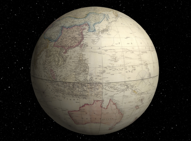
Arrowsmith, Aaron
Full Title
(Interactive Globe) A Chart of the World upon Mercator's projection exhibiting all the new discoveries to the present time : with the tracks of the most distinguished Navigators since the year 1700, carefully collected from the best charts, maps, voyages &c. Extant. And regulated from the accurate Astronomical Observations made in three voyages performed under the command of Capt. J. Cook in the years 1768, 69, 70, 71. -72, 73, 74, 75. - 77, 78, 79, & 80. Compiled and published by A. Arrowsmith, Hydrographer ... London published as the act directs, April 1st, 1790. by A. Arrowsmith. Sheets 1-8.
List No
11513.010
Note
Composite map of the World, sheets 1-8.
Author
[Lipszky, Janos, 1766-1826, Prixner, Gottfried, Karacs, Ferenc]
Full Title
Tab. I. Mappa Generalis Regni Hungariae partiumque adnexarum Croatiae, Slavoniae et Confiniorum Militarium Magni item Principatus Transylvaniae geometricis partium dimensionibus, recentissimisque astronomicis observationibus superstructa : adiectis finibus Provinciarum Bukovinae, Galliciae, Silesiae, Austriae, Styriae, Carinthiae, Carnioliae, Dalmatiae, Bosniae, Serviae, Valachiae et Moldaviae. Quam honoribus Serenissimi Principis Regii Josephi Archiducis Palatini dedicat Joannes de Lipszky. Pesthini Anno MDCCCVI (1806). (with) Repertorium locorum objectorumque in XII. tabulis Mappae regnorum Hungariae, Slavoniae, Croatiae, et Confiniorum Militarium, magni item principatus Transylvaniae occurrentium, quas aeri incisas vulgavit Joannes Lipszky de Szedlicsna ... Secundum varias in his provinciis usu receptas denominationes ab codem auctore elaboratum. Budae, typis Regiæ Universitatis, Pestanae, 1808.
List No
11326.003
Author
[Lipszky, Janos, 1766-1826, Prixner, Gottfried, Karacs, Ferenc]
Full Title
(Composite map) Mappa Generalis Regni Hungariae partiumque adnexarum Croatiae, Slavoniae et Confiniorum Militarium Magni item Principatus Transylvaniae geometricis partium dimensionibus, recentissimisque astronomicis observationibus superstructa : adiectis finibus Provinciarum Bukovinae, Galliciae, Silesiae, Austriae, Styriae, Carinthiae, Carnioliae, Dalmatiae, Bosniae, Serviae, Valachiae et Moldaviae. Quam honoribus Serenissimi Principis Regii Josephi Archiducis Palatini dedicat Joannes de Lipszky. Pesthini Anno MDCCCVI (1806). (with) Repertorium locorum objectorumque in XII. tabulis Mappae regnorum Hungariae, Slavoniae, Croatiae, et Confiniorum Militarium, magni item principatus Transylvaniae occurrentium, quas aeri incisas vulgavit Joannes Lipszky de Szedlicsna ... Secundum varias in his provinciis usu receptas denominationes ab codem auctore elaboratum. Budae, typis Regiæ Universitatis, Pestanae, 1808.
List No
11326.023
Note
Compiste of sheets 1-12.
Author
Maire, Nicolas M.
Full Title
(Title Page to) La topographie de Paris, ou, Plan detaille de la ville de Paris et de ses faubourgs : compose de vingt feuilles, d'un tableau d'assemblage, et d'une table alphabetique et statistique des rues, ruelles, culs-de-sac, passages, quais, places, carres, carrefours ... : compose de vingt feuilles, d'un tableau d'assemblage, et d'une table alphabetique et statistique ... Dediee a Mme Maret, ... Par Maire. A Paris, Chez l'Auteur, rue de Tournon, no 7 : Et chez les principaux libraires. M DCCC VIII (1808).
List No
13045.003
Author
Maire, Nicolas M.
Full Title
(Title Page to) Plan de la ville de Paris dresse gemetriquement d'apres celui de la Grive, avec ses changements et augmentations. (to accompany) La topographie de Paris, ou, Plan detaille de la ville de Paris et de ses faubourgs ... Par Maire. A Paris, Chez l'Auteur, rue de Tournon, no 7 : Et chez les principaux libraires. M DCCC VIII (1808).
List No
13045.006
Note
Title Page to: Revised plan of the City of Paris. Maps engraved by Benizy l’aîne, Jean Baptiste Marie Chamouin, A. Pelicier, and Perrier l’oncle.
Author
Maire, Nicolas M.
Full Title
Tableau d'assemblage. Paris dresse au cabinet topographique. Annee 1808. A Paris, Chez Maire. Grave Perrier Oncle. Ecrit par Pelicier. (to accompany) La topographie de Paris, ou, Plan detaille de la ville de Paris et de ses faubourgs ... Par Maire. DCCC VIII (1808).
List No
13045.007
Note
Engrave index map of the City of Paris. Includes note and reference. Maps showing streets, landmarks, places of interest, parks, castles,
Author
Maire, Nicolas M.
Full Title
Planche 1er. Grave par Chamouin. Ecrit par Benizy le. (to accompany) La topographie de Paris, ou, Plan detaille de la ville de Paris et de ses faubourgs ... Par Maire. DCCC VIII (1808).
List No
13045.008
Note
Engraved map, plate 1. Includes note.
Author
Maire, Nicolas M.
Full Title
(Composite Map) Paris dresse au cabinet topographique. Annee 1808. A Paris, Chez Maire. (to accompany) La topographie de Paris, ou, Plan detaille de la ville de Paris et de ses faubourgs ... Par Maire. DCCC VIII (1808).
List No
13045.028
Note
Composite map of Paris, sheets 1-20.
Author
Arrowsmith, Aaron
Full Title
(Composite map) A Chart of the World upon Mercator's projection exhibiting all the new discoveries to the present time : with the tracks of the most distinguished Navigators since the year 1700, carefully collected from the best charts, maps, voyages &c. Extant. And regulated from the accurate Astronomical Observations made in three voyages performed under the command of Capt. J. Cook in the years 1768, 69, 70, 71. -72, 73, 74, 75. - 77, 78, 79, & 80. Compiled and published by A. Arrowsmith, Hydrographer ... London published as the act directs, April 1st, 1790. by A. Arrowsmith. Sheets 1-8.
List No
11513.009
Note
Composite map of the World, sheets 1-8.
Author
Cramer, Zadok
Full Title
(Title page to) The Navigator: Containing Directions For Navigating The Monongahela, Allegheny, Ohio and Mississippi Rivers With An Ample Account Of These Much Admired Waters, From The Head Of The Former To the Mouth Of The Latter... With Accurate Maps Of The Ohio And Mississippi. To Which Is Added An Appendix, Containing An Account Of Louisiana, And Of The Missouri And Columbia Rivers, As Discovered By The Voyage Under Captains Lewis And Clarke. Sixth Edition - Improved And Enlarged. (Copy-right secured according to law.) Pittsburgh, Published by Zadok Cramer and sold at his Bookstore, Market-Street. [Price one Dollar.] From the Press of Cramer & Spear ... 1808.
List No
2652.002
Note
6th edition, improved and enlarged. 1st and 2nd editions never found, 3rd is 1802, 4th is 1804, 5th is 1806, thus this 6th edition is actually the 4th and the first to contain information on the Lewis and Clark expedition. See Yost for a good description of this book and Cramer. Manuscript notations on several maps indicate this copy was used for several trips down the river. The Navigator was the first of a long run of guides to the western rivers. Repairs to some leaves. Book rebound with quarter leather and "Cramer's Mississippi Navigator" embossed on the spine.
Author
[Heldensfeld, Anton Mayer von, Benedicti, Hieronimus]
Full Title
(Composite Map to) Carte von West-Gallizien : welche auf seiner allerhochsteri Befehl Kaiserlich Oesterreichischen. und Konigliche Apostolischen Majestat in den Jahren 1801 bis 1804 von unter der Direction des dermahhgen General Majors und General Quartiermeisters und Anton Mayer von Heldensfeld des militarischen Marien Theresien Ordens Ritter durch den Kaiserl. Konigl. Generalquartiermeisterstaab militarisch aufgenom-men Worden. Mit allerhochster Bewilligung herausgegeben und seiner des Generalissimus Erzherzog Carl_ Kaiserlichen Hoheit unterthanigst gewidmet as Generalquartiermeisterstaab gezeichnet, gestochen von und Hieronimus Benedicti. 1808.
List No
6873.014
Note
Composite of all 12 sheets. Very large and detailed map of West Galicia (Poland). Survey of West Gallicia was performed in 1801-1804 under the leadership of officer of Austrian army Anton Mayer von Heldensfeld (1777-1844). Engraved uncolored map, 212x178.5, segmented in 12 sheets, each 45x67, pasted on linen, each in 8 parts, 22x16.5. Drawn and engraved by Hieronimus Benedicti. Placed in slip cover and marbled cardboard case, with title : "West-Gallizien" on spine. Map showing major cities. fortress, church, etc. Relief shown by hachures.
Author
Rizzi Zannoni, Giovanni Antonio (1736-1814)
Full Title
(Composite of) No.1 - 31. Regno di Napoli.
List No
6854.036
Note
Composite of all 31 sheets of Atlante geografico del regno di Napoli. Relief shown pictorially. Prime meridian is Napoli.
Author
Arrowsmith, Aaron
Full Title
Map of the World on a Globular Projection, Exhibiting Particularly the Nautical Researches of Capn. James Cook, F.R.S. with all the Recent Discoveries to the Present Time, carefully drawn by A. Arrowsmith, Hydrographer to H.R.H. the Prince of Wales. The Plan Work Engraved by T. Foot. The Writing by Wigzell & Mozeen. This Map Is Respectfully Dedicated To Alexander Dalrymple Esqr. F.R.S. In Testimony of his many New and Valuable Geographical Communications To His most Obedient and very Humble Servant A. Arrowsmith. January 1st 1794. Additions to 1799. Do. to 1808. London, Published as the Act direct Jany. 1st 1794, by A. Arrowsmith, No. 10 Soho Square. I. Puke Sculpt. E. Dayes del. W. Wilson sculp.
List No
0030.000
Note
Dedicated to Alexander Dalrymple. Portraits of Cook and Dalrymple. 1st edition, 1794. Additions to 1799 and 1808. With outline color by country. Map is dissected into 24 sections, mounted on linen and edged in light blue silk. Folds into a new brown cloth folding case 34x27 with "World On A Globular Projection A. Arrowsmith 1808" stamped in gold on the spine.
Author
Arrowsmith, Aaron
Full Title
A Map Of The United States Of North America Drawn from a number of Critical Researches By A. Arrowsmith, Hydrographer to H.R.H. the Prince of Wales. No. 10 Soho Square. London. Published as the Act Directs by A. Arrowsmith, No. 10 Soho Square. Jan 1st, 1796. Additions to 1802.
List No
2098.001
Note
Watermark, J. Whatman 1811, NE sheet, lower left. Comparing to 79(d), 1804, I cannot find the changes indicated by Stevens, and comparing to 79(f), which only has added "-1815" in ms, I cannot find any changes either. It could be that this copy of 79(e) is later than the one Stevens saw as indicated by the 1811 watermark. There may be a 79(e) without the 1811 watermakr that is earlier. Outline color by state. Map is in four sheets, each dissected into 18 sections. Sheets fold, each with a label pasted to the linen backing reading "Sold by W. Faden, Geographer to His Majesty and to His Royal Highness the Prince of Wales. No. 5 Charing Cross." The four map sheets lie folded between two brown card end sheets, inside their original marbled paper slip case 22x13.5 with the same paste down label.
Author
Humboldt, Alexander von, 1769-1859
Full Title
Carte De La Vallee De Mexico Et Des Montagnes Voisines esquissee sur les Lieux en 1804, par Don Louis Martin redigee et corrigee en 1807 d'apres les operations Trigonometriques de Don Joaquin Velasquez et d'apres les observations Astronomiques et les mesures Barometriques de Mr. De Humboldt par Jabbo Oltmanns. 3. Dessine par G. Grossmann, termine par F. Friesen a Berlin 1807 et par A. Humboldt a Paris 1808. Grave par Barriere - et l'Ecriture par L. Aubert pere.
List No
0328.005
Note
Map without color, includes cities, villages, haciendas, and astronomical observatory points.
Author
Humboldt, Alexander von, 1769-1859
Full Title
Profile du Canal de Huehuetoca (Desague Real.) Creuse pour preserver la Ville de Mexico du danger des Inondations. 15. Redige d'apres les dessins de Don Ignacio Castera et Don Luis Martin par F. Friesen 1808. Grave par Bouquet - et l'Ecriture gravee par L. Aubert pere.
List No
0328.015
Note
Profile of the Hueheutoca canal. In color.
Author
Smith, Charles
Full Title
(Covers to) Smith's New General Atlas Containing Distinct Maps Of all the Principal Empires, Kingdoms, & States Throughout the World Carefully delineated from the best Authorities extant. London, Printed for C. Smith, Mapseller extraordinary, To his Royal Highness the Prince of Wales, No. 172, Strand. 1808. (title page only) Halliwell fect.
List No
0908.001
Note
Bound in half leather green marbled paper covered boards with "Atlas" stamped in gilt on the spine.
Author
Smith, Charles
Full Title
(Title Page) Smith's New General Atlas Containing Distinct Maps Of all the Principal Empires, Kingdoms, & States Throughout the World Carefully delineated from the best Authorities extant. London, Printed for C. Smith, Mapseller extraordinary, To his Royal Highness the Prince of Wales, No. 172, Strand. 1808. (title page only) Halliwell fect.
List No
0908.002
Author
Smith, Charles
Full Title
(Table of Contents) Contents. Advertisement.
List No
0908.003
Author
Smith, Charles
Full Title
Western Hemisphere.
List No
0908.004
Author
Smith, Charles
Full Title
Eastern Hemisphere.
List No
0908.005
Author
Smith, Charles
Full Title
The World on Mercator's Projection.
List No
0908.006
|
![Covers: [A Complete Set of 9 Charts in Atlas Form to Illustrate the Chronology of British Nobility]](https://www.davidrumsey.com/rumsey/Size2/RUMSEY~8~1/205/15773001.jpg)


![Covers: Carta Militar das Principaes Estradas de Portugal [Military Map of the Principal Roads of Portugal]](https://www.davidrumsey.com/rumsey/Size2/RUMSEY~8~1/199/15242001.jpg)
![Carta Militar das Principaes Estradas de Portugal [Military Map of the Principal Roads of Portugal]](https://www.davidrumsey.com/rumsey/Size2/RUMSEY~8~1/199/15242002.jpg)