|
Author
[Norman, William, -1807, Pinkham, Paul, 1736-1799]
Full Title
A chart of Nantucket Shoals surveyed by Capt. Paul Pinkham. Boston. Published & sold by John Norman, no.75, Newbury Street, Feb. 16th, 1791.
List No
14485.007
Note
Nautical chart representing the Nantucket Shoals. With one inset map: Plymouth Bay. Shows islands, cities, bodies of water, drainage, coastlines, bays, ports, anchorage, shoals, rocks and depths, given in fathoms. Features pictorial representations of buildings, including windmills and a light house. Includes rhumb lines, latitudinal and longitudinal lines, as well as a compass rose with north oriented toward top of sheet, a bar scale given in miles, and arrows referring to the directions of water currents. With historical text. Black and white engraving. Chart is 50 x 77 cm, on double sheet 54 x 83 cm. "According to Act of Congress."
Author
Chauchard, M.
Full Title
(Composite msp to) Sheets I-IV. Carte de la partie septentrionale de l'Italie, Par M. Chauchard,
List No
15629.020
Note
Four sheets that make up the map, total size 98 x 166 cm
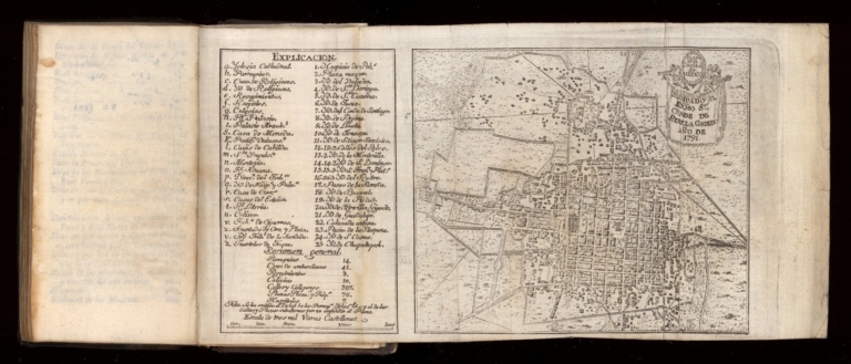
Author
Zúñiga y Ontiveros, Mariano
Full Title
Plano de la Ciudad de México
List No
15615.004
Author
Gussefeld, Franz Ludwig
Full Title
19. Provincia Extremadura... 1791
List No
15599.020
Author
Faden, William, 1749-1836
Full Title
Europe, exhibiting its principal states, &c. London. Published by W. Faden, Geographer to the King, Charing Cross, July 1st. 1791. W. Palmer sculpt.
List No
14383.011
Note
Map of Europe, as of 1791. Shows national boundaries, cities, topography, bodies of water, drainage, coastlines and islands. Relief shown pictorially. Includes latitudinal and longitudinal lines, as well as three bar scales. Decorative cartouche. Hand-colored engraving. Map is 52 x 65 cm, on double sheet 55 x 75 cm. With stamp: Liverpool Library.
Author
Kindermann, Joseph Karl, 1744-1808
Full Title
Oberkaernten oder der Villacher Kreis. Entworfen und gezeichnet von Josepii Karl Kindermann. Gestochen zu Wien von Christoph Junker. Verlegt bey Franz Xaver Miller. Buchhaendlern zu Graetz, 1791. (to accompany) (Atlas von Inner Osterreich).
List No
11802.009
Note
Uncolored map of the Oberkaernten or the Villach district. Includes overview text of the covered areas, tables, distances and legend. Relief shown by hachures.
Author
Cassini, Gio. Ma. (Giovanni Maria), 1745-approximately 1824
Full Title
(Contents to) Indice delle tavole geographiche contenute nel primo volume del presente nuovo atlante. Presso la Calcograf. Camerale, 1791.
List No
14000.022
Note
Table of contents lists "Frontispizio", "Indice" and 55 map titles. Includes decorative title cartouche and floral border surrounding title.
Author
[Lawrence, Martin, Washington, George]
Full Title
North Carolina, south Carolina, and Georgia, showing in red the places visited by George Washington; the insert map gives the rout of his whole southern tour in 1791.
List No
0465.038
Note
Color map. Showing Washington's headquarters, battlefield, capital of the United States, locality known and approximate.
Author
[Lawrence, Martin, Washington, George]
Full Title
Washington's campaign with Braddock in 1755.
List No
0465.039
Note
Color map. Showing battlefield, locality known and approximate.
Author
[Akademii Nauk SSSR, Academy of Sciences, St. Petersburg]
Full Title
(Covers to) (Atlas Russicus= Atlas Rossiiskoi Imperii. Sankt Peterburg, Geograficheskii Department Akamii Nauk).
List No
11106.001
Note
A collection of 10 outline hand color maps, on white or blue heavy paper, printed by the Academy of Sciences, St. Petersburg, and Imperial Academy of Sciences. Dated 1777-1791. While not a part of the Atlas Russicus, they were issued in the years following the 1845 publication of the Atlas Russicus and were bound together in various compilations, usually without a title page, and formed a later edition of the Atlas Russicus. Phillips reports a volume of these maps and other maps issued by the Academy in St. Petersburg with the title Atlas of the Empire of Russia. Bound in red marbled, half leather covers, with no title on or inside. Created in accordance with geographic rules and the newest observation. Showing administrative boundaries, cities, towns, rivers, canals, roads, forests, fortress, etc
Author
[Akademii Nauk SSSR, Islenevym, Ivan, Academy of Sciences, St. Petersburg]
Full Title
Generalnaia karta Azovskoi gubernii s eia uezdami : Sochinennaia I. Islenevym 1782 goda. Vyr. uche. S. Maksimov. (Atlas Russicus= Atlas Rossiiskoi Imperii).
List No
11106.002
Note
Outline hand color map No.1. General map of the Azov province. Showing administrative boundaries, cities and towns, rivers, canals, roads, etc. Includes decorative title cartouche.
Author
[Akademii Nauk SSSR, Islenevym, Ivan]
Full Title
Generalnaia karta na Novorossiiskoi gubernii razdelennoi Uezdy. Sochnennaia v 1779 godu. Ivanom Islenevym, Vyrez. K. Frolov. (Atlas Russicus= Atlas Rossiiskoi Imperii).
List No
11106.003
Note
Outline hand color map No.2. General map of Novorossiysk province and it's counties. Showing administrative boundaries, cities and towns, rivers, canals, roads, etc. Includes decorative title cartouche.
Author
[Akademii Nauk SSSR, Academy of Sciences, St. Petersburg]
Full Title
Generalnaia karta Kazanakoi gubernii. Sochinennaia po noveishim izvestiiam v 1779 godu. Fedorom Chernym. Vyrez. S. Maksimo. (Atlas Russicus= Atlas Rossiiskoi Imperii).
List No
11106.004
Note
Outline hand color map No.3. General map of Kazan province and it's counties. Showing administrative boundaries, cities and towns, rivers, canals, roads, etc. Includes decorative title cartouche.
Author
[Akademii Nauk SSSR, Academy of Sciences, St. Petersburg]
Full Title
Generalnaia karta Kyrskogo namestnichestva. Razdelennaia na 15 Uezdov, sochinennaia po noveishim izvestiiam adiunktom Fedorom Chernym, 1788 goda. Gravir. I. Kuvakin. (Atlas Russicus= Atlas Rossiiskoi Imperii).
List No
11106.005
Note
Outline hand color map No.4. General map of the Kursk governorship. Showing administrative boundaries, cities and towns, rivers, canals, roads, etc. Includes decorative title cartouche.
Author
[Akademii Nauk SSSR, Academy of Sciences, St. Petersburg]
Full Title
Generalnaia karta Ufimskogo namestnichestva. Razdelennaia na 13 Uezdov, Sochinennaia po noveishim izvestiiam adiunktom Fedorom Chernym,1791 goda. (Atlas Russicus= Atlas Rossiiskoi Imperii).
List No
11106.006
Note
Outline hand color map No.5. General map of Ufa governorship. Showing administrative boundaries, cities and towns, rivers, canals, roads, etc. Includes decorative title cartouche. Relief shown pictorially.
Author
[Akademii Nauk SSSR, Academy of Sciences, St. Petersburg]
Full Title
Generalnaia karta Nizhegorodskogo Namestnichestva. Razdelennaia na 13 Uezdov, Sochinennaia po noveishim izvestiiam adiunktom Fedorom Chernym,1788 goda. (Atlas Russicus= Atlas Rossiiskoi Imperii).
List No
11106.007
Note
Outline hand color map No.6. General map of Nizhny Novgorod governorship. Showing administrative boundaries, cities and towns, rivers, canals, roads, etc. Includes decorative title cartouche. Relief shown pictorially.
Author
[Akademii Nauk SSSR, Academy of Sciences, St. Petersburg]
Full Title
Generalnaia karta Viatskato Namestnichestva. Razdelennaia na 13 Uezdov, Sochinennaia po noveishim izvestiiam adiunktom Fedorom Chernym,1791 goda. (Atlas Russicus= Atlas Rossiiskoi Imperii).
List No
11106.008
Note
Outline hand color map No.7. General map of Vyatsky governorship. Showing administrative boundaries, cities and towns, rivers, canals, roads, etc. Includes decorative title cartouche. Relief shown pictorially.
Author
[Akademii Nauk SSSR, Academy of Sciences, St. Petersburg]
Full Title
Generalnaia karta Kryma. Sochinennaia po noveishim izvestiiam adiunktom Fedorom Chernym,1790 goda. Gravir. I. Kuvakin. (Atlas Russicus= Atlas Rossiiskoi Imperii).
List No
11106.009
Note
Outline hand color map No.8. General map of Crimea. Showing administrative boundaries, cities and towns, rivers, canals, roads, etc. Includes decorative title cartouche. Relief shown by hachures.
Author
[Akademii Nauk SSSR, Academy of Sciences, St. Petersburg]
Full Title
Karta techneiia Reki Irtysha oshb Omskoi Kreposshi do Tovolska. Sochinennaia pri Imperatorskoi Akacemii Nauk. I. Islenevym. v. 1780. Vyrezak U.L. Sergeev. (Atlas Russicus= Atlas Rossiiskoi Imperii).
List No
11106.010
Note
Outline hand color map No.9. Showing the flow of the Irtysh River, through Omsk fortress from Tobolsk. Composed at the Imperial Academy of Sciences in 1780. Shows cities and towns, rivers, canals, roads, etc. Includes decorative title cartouche. Relief shown by hachures.
Author
[Akademii Nauk SSSR, Academy of Sciences, St. Petersburg]
Full Title
Karta reki Irtysha iuzhnuiu chast Sibiriskoi gubernii protekaiushchei i byvshikhb Zengorskikhb Kalmyk vladenii. Sochinennaia Ivanom Islenevym, v. 1777 goda. Vyrezak U.L. Sergeev. (Atlas Russicus= Atlas Rossiiskoi Imperii).
List No
11106.011
Note
Outline hand color map No.10. Map of the Irtysh River, the southern part of the Siberian province, and former Zengorskih Kalmyk possessions. Shows cities, villages, mountain ranges and peaks, rivers, lakes, canals, roads, etc. Includes decorative title cartouche. Relief shown pictorially.
Author
[Grenet, Abbe, Bonne, Rigobert]
Full Title
Etat De la Republique de Venise. Par P. Santini. 1791. (to accompany) Atlas portatif a l'usage des colleges, pour servir a l'intelligence des auteurs classiques. 16
List No
11172.019
Note
Copper engraved outline hand colored map. Showing boundaries, towns, and rivers. Prime meridians are Paris and Ferro. Relief shown pictorially.
Author
[Grenet, Abbe, Bonne, Rigobert]
Full Title
Nouvelle carte del Etat de Milan avec ces de Mantoue et de Parme. Par M. Bonne Ingener. Hydrographe de la Marine. Par P. Santini. 1791. (to accompany) Atlas portatif a l'usage des colleges, pour servir a l'intelligence des auteurs classiques. 17.
List No
11172.020
Note
Copper engraved outline hand colored map. Showing boundaries, towns, roads, and rivers. Prime meridians are Paris and Ferro. Relief shown pictorially.
Author
[Grenet, Abbe, Bonne, Rigobert]
Full Title
La Savoie, Le Piemont, Le Mont-Ferrat, Et La Republique De Genes. Par M. Bonne. A Venise, Par P. Santini. 1791. (to accompany) Atlas portatif a l'usage des colleges, pour servir a l'intelligence des auteurs classiques. 18.
List No
11172.021
Note
Copper engraved outline hand colored map. Showing boundaries, towns, roads, and rivers. Prime meridians are Paris and Ferro. Relief shown pictorially.
Author
[Grenet, Abbe, Bonne, Rigobert]
Full Title
Carte des Indes en Deca et au Dela du Gange; avec les Isles de la Sonde, Borneo, les Moluques et les Philippines partie Occidentale. Par M. Bonne, ingenieur Hydrographe de la Marine. A' Venise, Par P. Santini 1791. (to accompany) Atlas portatif a l'usage des colleges, pour servir a l'intelligence des auteurs classiques. 37
List No
11172.040
Note
Copper engraved outline hand colored map. Showing boundaries, rivers, major cities, towns and villages. Prime meridians are Paris and Ferro. Relief shown pictorially.
Author
[Grenet, Abbe, Bonne, Rigobert]
Full Title
Carte des royaumes de Fez, d'Alger, de Tunis, et de Tripoli. Par M. Bonne, ingenr. Hydrographe de la Marine. A' Venise 1791, Par P. Santini. (to accompany) Atlas portatif a l'usage des colleges, pour servir a l'intelligence des auteurs classiques. 39.
List No
11172.042
Note
Copper engraved outline hand colored map of North Africa from the Straits of Gibraltar over to Tripoli. Showing boundaries, rivers, major cities, towns and villages. Prime meridians are Paris and Ferro. Relief shown pictorially.
Author
[Grenet, Abbe, Bonne, Rigobert]
Full Title
Carte de l'Egypte moderne, Avec la partie Orientale des etats de Tripoli. Par M. Bonne, ingenieur - Hydrographe de la Marine. A' Venise 1791, Par P. Santini. (to accompany) Atlas portatif a l'usage des colleges, pour servir a l'intelligence des auteurs classiques. 40.
List No
11172.043
Note
Copper engraved outline hand colored map. Showing boundaries, rivers, major cities, towns and villages. Prime meridians are Paris and Ferro. Relief shown pictorially.
Author
[Grenet, Abbe, Bonne, Rigobert]
Full Title
Mappa Italiae antique descripta A Rto. Bona, Primario Hydrographo Navali. Venetiis Apud P. Santini 1791. (to accompany) Atlas portatif a l'usage des colleges, pour servir a l'intelligence des auteurs classiques. 53.
List No
11172.056
Note
Copper engraved outline hand colored map. Prime meridians are Paris and Ferro. Relief shown pictorially.
Author
[Grenet, Abbe, Bonne, Rigobert]
Full Title
Mappa Aegypti antiquae descripta a Rto. Bona, Primario Hydrographo Navali. Venetiis Apud P. Santini 1791. (to accompany) Atlas portatif a l'usage des colleges, pour servir a l'intelligence des auteurs classiques. 61.
List No
11172.064
Note
Copper engraved outline hand colored map. Prime meridians are Paris and Ferro. Relief shown pictorially.
Author
Chollet, L.
Full Title
Chollet? - 1791 or earlier. S Doc 91 55 2. 68. Map of the Coast Region of the Essequibo Colony; Probably Identical with that Transmitted to the West India Company by L. Chollet, Colonial Surveyor, 1791. Reproduced from the Original Manuscript Bought, in 1896, in Holland, for the Commission. Photo. Lith. by A. Hoen & Co., Baltimore, MD.
List No
1122.073
Note
Color.
Author
Wilkinson, Robert
Full Title
A New Map of Prussia.
List No
1201.016
Author
Wilkinson, Robert
Full Title
A New Map of Germany divided into Circles from the Best Authorities.
List No
1201.017
Author
Wilkinson, Robert
Full Title
A New Map of Germany divided into Circles from the Best Authorities.
List No
1202.018
Author
Wilkinson, Robert
Full Title
A New Accurate Map of New South Wales with Norfolk and Lord Howes Islands Port Jackson, &c.
List No
1202.047
Author
[Schraembl, Franz Anton, Bowles, Carington]
Full Title
27. Uebersicht der Europaeische Seekuesten, Verfasst von Herrn Carington Bowles, Neu Herausgegeben von Herrn F.A. Schrembl. MDCCXCI.
List No
12498.047
Author
[Schraembl, Franz Anton, D'Anville, Choiseul-Gouffier]
Full Title
90. Karte von Griechenland. Nach den neuesten und besten Karten des Herrn d'Anville, Choiseul-Gouffier etc. etc. Herausgegeben von Herrn F.A. Schraembl. MDCCXCI.
List No
12498.135
Note
No sheet 89.
Author
Cassini, Gio. Ma. (Giovanni Maria), 1745-approximately 1824
Full Title
(32) Lo Stato Ecclesiastico delineato sulle ultime osservazioni e diviso nelle sue provincie. Roma, presso la Calcografia Camerale, 1791.
List No
14000.056
Note
Relief shown pictorially. Includes decorative title cartouche and bar scales. In Volume I.
Author
Cassini, Gio. Ma. (Giovanni Maria), 1745-approximately 1824
Full Title
(34) La Legazione d'Urbino la Marca l'Umbria lo Stato di Camerino i Territori di Perugia e di Orvieto ed il Governo di Citta' di Castello. Roma, presso la Calcografia Camle., 1791.
List No
14000.058
Note
Relief shown pictorially. Includes decorative title cartouche and bar scales. In Volume I.
Author
Cassini, Gio. Ma. (Giovanni Maria), 1745-approximately 1824
Full Title
(35) Le Legazioni di Bologna di Ferrara e della Romagna. Roma, presso la Calcografia Camle., 1791.
List No
14000.059
Note
Relief shown pictorially. Includes decorative title cartouche and bar scales. In Volume I.
Author
Cassini, Gio. Ma. (Giovanni Maria), 1745-approximately 1824
Full Title
(36) La parte settentrionale del Gran Ducato di Toscana che comprende porzioni dello Stato Florentino e del Territorio Pisano con la Republica di Lucca. Roma, presso la Calcografia Camle., 1791.
List No
14000.060
Note
Relief shown pictorially. Includes decorative title cartouche and bar scales. In Volume I.
Author
Cassini, Gio. Ma. (Giovanni Maria), 1745-approximately 1824
Full Title
(37) La parte meridionale del Gran Ducato di Toscana che comprende lo Stato Senese e Porzione del Territorio Pisano col Principato di Piombino e lo Stato de' Presidj. Roma, presso la Calcografia Camle., 1791.
List No
14000.061
Note
Relief shown pictorially. Includes decorative title cartouche. In Volume I.
Author
Cassini, Gio. Ma. (Giovanni Maria), 1745-approximately 1824
Full Title
(Composite to) La parte settentrionale del Gran Ducato di Toscana che comprende porzioni dello Stato Florentino e del Territorio Pisano con la Republica di Lucca ... -- La parte meridionale del Gran Ducato di Toscana che comprende lo Stato Senese e Porzione del Territorio Pisano col Principato di Piombino e lo Stato de' Presidj. Roma, presso la Calcografia Camle., 1791.
List No
14000.062
Note
Composite to maps 36 and 37 (as numbered in index) in Volume I. Includes decorative title cartouche on each of the two sheets: settentrionale and meridionale.
Author
Cassini, Gio. Ma. (Giovanni Maria), 1745-approximately 1824
Full Title
(38) Lo Stato Veneto da terra diviso nelle sue provincie. Prima parte che comprende Il Bergamasco Il Cremasco Il Feltrino e porzioni del Bresciano Veronese Vicentino Padovano Dogado Trevisano e Friuli. Roma, presso la Calcografia Camle., 1791.
List No
14000.063
Note
Relief shown pictorially. Includes decorative title cartouche. In Volume I.
Author
Cassini, Gio. Ma. (Giovanni Maria), 1745-approximately 1824
Full Title
(39) Lo Stato Veneto da terra diviso nelle sue provincie. Seconda parte che comprende Porzioni del Dogado del Trevisano del Friuli e Dell' Istria. Roma, presso la Calcografia Camle., 1791.
List No
14000.064
Note
Relief shown pictorially. Includes decorative title cartouche. In Volume I.
Author
Cassini, Gio. Ma. (Giovanni Maria), 1745-approximately 1824
Full Title
(40) Lo Stato Veneto da terra diviso nelle sue provincie. Terza parte che comprende Il Polesine e Porzioni del Bresciano Veronese Vicentino Padovano e del Dogado. Roma, presso la Calcografia Camle., 1791.
List No
14000.065
Note
Relief shown pictorially. Includes decorative title cartouche and bar scales. In Volume I.
Author
Cassini, Gio. Ma. (Giovanni Maria), 1745-approximately 1824
Full Title
(41) Lo Stato Veneto da terra diviso nelle sue provincie. Quarta parte che comprende Porzioni del Dogado e Dell' Istria. Roma, presso la Calcografia Camle., 1791.
List No
14000.066
Note
Relief shown pictorially. Includes decorative title cartouche. In Volume I.
Author
Cassini, Gio. Ma. (Giovanni Maria), 1745-approximately 1824
Full Title
(Composite to) Lo Stato Veneto da terra diviso nelle sue provincie. Prima parte che comprende Il Bergamasco Il Cremasco Il Feltrino e porzioni del Bresciano Veronese Vicentino Padovano Dogado Trevisano e Friuli ... -- ... Seconda parte che comprende Porzioni del Dogado del Trevisano del Friuli e Dell' Istria ... -- ... Terza parte che comprende Il Polesine e Porzioni del Bresciano Veronese Vicentino Padovano e del Dogado ... Quarta parte che comprende Porzioni del Dogado e Dell' Istria. Roma, presso la Calcografia Camle., 1791.
List No
14000.067
Note
Composite to maps 38 through 41 (as numbered in index) in Volume I. Includes decorative title cartouche on each of the 4 sheets: Prima, Seconda, Terza and Quarta.
Author
Cassini, Gio. Ma. (Giovanni Maria), 1745-approximately 1824
Full Title
(43) L'Alta Lombardia. Primo foglio che comprende parte degli Stati del Re di Sardegna cioe' la Savoja e porzioni del Piemonte e del Monferrato. Roma, presso la Calcografia Camle., 1791.
List No
14000.069
Note
Relief shown pictorially. Includes decorative title cartouche. In Volume I.
Author
Cassini, Gio. Ma. (Giovanni Maria), 1745-approximately 1824
Full Title
(44) L'Alta Lombardia. Secondo foglio che comprende gli Stati Austriaci della medesima e porzione degli stati del Re di Sardegna. Roma, presso la Calcografia Camle., 1791.
List No
14000.070
Note
Relief shown pictorially. Includes decorative title cartouche. In Volume I.
Author
Cassini, Gio. Ma. (Giovanni Maria), 1745-approximately 1824
Full Title
(45) L'Alta Lombardia. Terzo foglio che comprende parte degli Stati del Re di Sardegna e parte della Repubblica di Genova. Roma, presso la Calcografia Camle., 1791.
List No
14000.071
Note
Relief shown pictorially. Includes decorative title cartouche. In Volume I.
Author
Cassini, Gio. Ma. (Giovanni Maria), 1745-approximately 1824
Full Title
(46) L'Alta Lombardia. Quarto foglio che comprende parte degli Stati del Re di Sardegna parte della Repubblica di Genova e i Ducati di Parma Placenza e di Modena. Roma, presso la Calcografia Camle., 1791.
List No
14000.072
Note
Relief shown pictorially. Includes decorative title cartouche and bar scales. In Volume I.
|