|
Author
Elwe, Jan Barend
Full Title
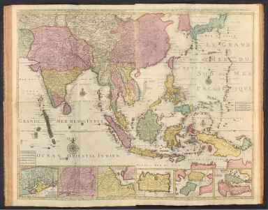
(Composite Map to) 1 Partie de la nouvelle grande carte des Indes Orientales, contenant les Terres du Mogol, Surate, Malabar, Cormandel, Bengale, Aracan, Pegu, Siam, Camboje, Tonquin, & une partie de la Chine -- 2 Partie de la nouvelle grande carte des Indes Orientales, contenant les Empires de la Chine & du Japon, les Isles Philippines, Couchin, & les Isles Marianes -- 3 Partie de la nouvelle grande carte des Indes Orientales, contenant les Isles Maldives, Ceyi, An, Malacca, Sumatra &c. avec les terres adjacentes de Couchin, Negombo, Colombo & Sourabaia -- 4 Partie de la nouvelle grande carte des Indes Orientales, contenant les Isles de Borneo, Java, Celebes, Mindanao, Gilolo, Molucques, La Nouvelle Guinée, La Nouvelle Bretagne, & les Nouvelles Philippines; avec les Isles de Sumbawa, Serbira, Solor, Bouton & Pangesane dressée avec soin, sur pluseurs cartes manuscrites, par un habile connoisseur; & publiée a Amsterdam par Jan Bt. Elwe. MDCCXCII.
List No
14478.048
Note
Composite map of Asia, including the Mughal Empire [current-day India, Pakistan and Afghanistan], the Malabar, Coromandel, Bengal and Aracan regions, Siam [current-day Thailand], Camdodia, Tonquin [current-day Vietnam], China, Japan, the Philippines, the Mariana Islands, Maldives, Ceylon [current-day Sri Lanka], Malaysia, Sumatra (Indonesia), Borneo, Java, Celebes [Sulawesi], Gilolo [Halmahera], the Maluku Islands (Indonesia), Mindanao (Philippines) and Papua New Guinea. Shows countries, regions, cities, topography, vegetation, bodies of water, drainage, coastlines and islands. Relief shown pictorially. Includes compass roses with north oriented toward top of sheet, bar scales, latitudinal and longitudinal lines, and descriptive notes throughout. Inset maps: Carte de Royaume de Couchin de Coilan et de Cranganor -- Carte de Nigombo, Colombo -- Carte de Princepaute de Soerabaye et Terre de Grissik -- Isle de Sumbawa -- Isles de Serbira et de Solor -- Isles de Bouton et Pangesane. Hand-colored engraving. Composite map is 98 x 118 cm, on four double sheets, together 116 x 140 cm.
Author
[U.S. Coast and Geodetic Survey, U.S. Army Air Forces]
Full Title
Thailand
List No
15328.010
Author
[Nolin, Jean Baptiste, 1648-1708, Coronelli, Vincenzo (1650-1718)]
Full Title
Les Royaumes qui luy font Tributaires et les Isles de Sumatra, Andemaon, etc. Corrigés selon les Observations des Six Peres Jesuites Envojez par le Roy en Qualité de ses Mathematiciens dans les Indes, et à la Chine ou est Aussi Tracèe la Route qu'ils ont teniie par le Destroit de la Sonde Jusqu'á Siam. Dressé et dedie à Mr. l'Abbé de Dangeau, par son tres humble Servit. le Pere Coronelli Cosmographe de la Republique de Venise, avec Privilege du Roy. A Paris, Chez Jean Baptiste Nolin, sur le Quay de l’Horloge du Palais à l'enseigne de la Place des Victoires. 1687.
List No
14353.044
Note
Map of Sumatra, Indonesia, the Andaman Islands, India, and Siam [Thailand]. Title translates to: The Kingdoms ... and the Isles of Sumatra, Andemaon, etc. Shows political boundaries, cities, topography, lakes, drainage, coastlines, shoals, islands, soundings, anchorage and ocean routes. Relief shown pictorially. Includes latitudinal and longitudinal lines, as well as explanatory notes. Decorative cartouche with indigenous figures and an elephant. Black and white engraving with hand-colored borders. Map is 61 x 44 cm, on double sheet 67 x 50 cm. (Plate number handwritten in ink on verso.)
Author
[Mercator, Gerhard, 1512-1594, Hondius, Jodocus, 1563-1612, Hondius, Hendrik, 1597-1651]
Full Title
India Orientalis
List No
10534.347
Author
[Mercator, Gerhard, 1512-1594, Hondius, Jodocus, 1563-1612]
Full Title
India Orientalis
List No
10501.490
Author
[Placide de Sainte-Helene, 1648-1734, Du Val, Pierre, 1619-1683]
Full Title
Carte du Royaume de Siam et des pays circonvoisins. Par le P. Placide Augustin Deschausse, Geographe ordinaire de sa Majeste. Dediee a Monsieur le chevalier de Chaumont, ambassadeur du roi a Siam. C. Rousset sculp. A Paris, chez M.elle Du-Val ...1686. (to accompany) Cartes de geographie par Le Rd. Pere Placide.
List No
13031.021
Note
Engraved outline hand colored map of the Kingdom of Siam and the neighboring countries. Showing political divisions, many place names, landmarks, rivers and mountains. Map depicts the route from just west of the Sunda Straits and up the east side of the peninsula via the Gulf of Siam. Includes decorative title cartouche, compass rose and vignettes of sailing ships. Relief shown pictorially.
Author
Arrowsmith, John
Full Title
Burmah, Siam, and Cochin China, by J. Arrowsmith. London, pubd. 15 Feby. 1832 by J. Arrowsmith, 35 Essex Street, Strand.
List No
0036.031
Note
Engraved map. Hand colored boundaries. Relief shown by hachures.
Author
Brue, Adrien Hubert, 1786-1832
Full Title
Carte generale des Indes en-deca et au-dela du Gange, par A.H. Brue, Geographe de S.A.R. Monsieur. A Paris, Chez l'Auteur, rue des Macons-Sorbonne, no. 9, et chez les principaux marchands de geographie. Juin 1821.
List No
0096.045
Note
Hand colored engraved map. Relief shown by hachures. Prime meridian: Paris.
Author
[Dower, John, Higgins, W.M.]
Full Title
Burman Empire, and Hindoo-Chinese States.
List No
0247.097
Author
Johnson, A.J.
Full Title
Johnson's Hindostan Or British India By Johnson And Ward. (insets): The Island and Town of Bombay, Madras and its Suburbs, and Calcutta.
List No
0535.066
Note
In full color. Vignette of the Government House and Treasury in Calcutta. Relief shown by hachures. Meridians Greenwich and Washington D.C.
Author
Polish Army Topography Service
Full Title
Indonesia, Thailand and Malaya. Pergamon World Atlas. Pergamon Press, Ltd. & P.W.N. Poland 1967. Sluzba Topograficzna W.P.
List No
0737.156
Note
Detailed physical and political map.
Author
Stanford, Edward
Full Title
Indo-China.
List No
0949.079
Note
Full color. Relief shown by hachures and spot heights. Shows settlements, roads, railroads, etc.
Author
[Stieler, Adolf, Barich, C.]
Full Title
66. Hinter-Indien u. Archipel.
List No
0961.146
Author
[Stieler, Adolf, Barich, C.]
Full Title
Nr. 66. Hinter-Indien u. Archipel. ... C. Barich. (inset) Tonkin und Uber-Laos. Cambodia und Cochinchina.
List No
0962.146
Author
Thomson, John
Full Title
Birman Empire. Engd. by Moffat & Smellie Edinr. Drawn & engraved for Thomson's New general atlas. (1817)
List No
1007.047
Note
Engraved map. Hand colored. Relief shown by hachures. Covers present-day Burma and parts of Bhutan, India, Bangladesh, Thailand, Cambodia, Laos, Vietnam and southern China.
Full Title
Siam and the Malay Archipelago. (with) Java. (Published at the office of "The Times," London, 1895)
List No
1010.055
Note
Color map with inset. Relief shown by hachures and spot heights. Show settlements, railroads, etc. Scale of Java map 1:9,000,000.
Author
Society for the Diffusion of Useful Knowledge (Great Britain)
Full Title
Asiatic Archipelago.
List No
10911.061
Author
[Andriveau-Goujon, J., Brue, Adrien Hubert, 1786-1832]
Full Title
Carte generale des Indes en-deca et au-dela du Gange, par A.H. Brue, Geographe de S.A.R. Monsieur. A Paris, Chez l'Auteur, rue des Macons-Sorbonne, no. 9, et chez les principaux marchands de geographie. Juin 1821.
List No
11124.033
Note
Outline hand color engraved map. Shows political and administrative divisions, towns, villages, roads, postal routes, etc. Relief shown by hachures. Prime meridian is Paris. Includes color coded index.
Author
[Harrison, Richard Edes, St. Louis Post dispatch]
Full Title
Burma, Thailand and Malaya. Special Atlas Section - St. Louis Post Dispatch. Sunday, September 12, 1954. Wenschow Relief-like map from Denoyer-Geppert Co. Chicago. Copyright.
List No
11507.005
Note
Color map, with descriptive text. Shows political and administrative divisions, and place names. Relief shown by shadings.
Author
Zatta, Antonio, active 1757-1797
Full Title
Regni d'Aracan del Pegu di Siam di Camboge e di Laos. Venezia 1785. Presso Antonio Zatta, e Figli. (to accompany) Atlante novissimo ... Tomo IIII. Con privilegio dell Eccelimo Senato. (tomo I-IV).
List No
11598.207
Note
Engraved hand-colored in outline, double-page map, with decorative title cartouche. Shows political and administrative divisions, cities, towns, rivers and mountains. Relief shown pictorially.
Author
[Santini, Paolo, Robert]
Full Title
36. Les Indes Orientales.
List No
12039.117
Author
[Jaillot, Alexis Hubert, 1632?-1712, Mortier, Pierre, Sanson, Nicolas, 1600-1667]
Full Title
Le Royaume de Siam.
List No
12178.207
Author
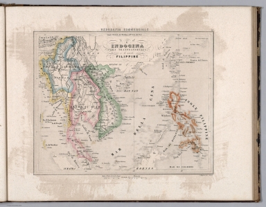
Marmocchi, Francesco C.
Full Title
15. L'Indocina (India Transgangetica) le insole Filippine.
List No
12235.016
Author
Stieler, Adolf
Full Title
64. Ostindische Inseln. (inset) Java. Die Strassen. Atjeh oder Atschin. Batavia.
List No
12240.077
Author
[Stieler, Adolf, Haack, H.]
Full Title
71. Hinterindien.
List No
12248.151
Author
[Stieler, Adolf, Haack, H.]
Full Title
72. Malaiische Inselwelt. (insets) Riukiu - Inseln. Hanoi. Der Canton-Strom.
List No
12248.153
Author
[Wyld, James, 1812-1887, Wyld, James, 1790-1836]
Full Title
Map of the Burman Empire : Including also Siam, Cochin-China, Ton-king and Malaya. By James Wyld. London. Published by James Wyld. 1838. (to accompany) A new general atlas of modern geography : consisting of a complete collection of maps of the four quarters of the globe ...
List No
13170.047
Note
Engraved map, hand colored in outline. Covers South East Asia, from Calcutta to Hong Kong. Shows political and administrative boundaries, major cities and towns. Relief shown by hachures. Prime meridian is Greenwich.
Author
[Sydow, Emil von., 1812-1873, Wagner, Hermann, 1840-1929]
Full Title
Innerasien, Indien, China. Gotha : Justus Perthes. Sydow-Wagners method. Schul-Atlas. XXI.
List No
13557.123
Note
Map of Inner Asiaian countries. With insets: Peiping. Kalkutta. Bonne'sche Projektion.
Author
[Sydow, Emil von., 1812-1873, Wagner, Hermann, 1840-1929]
Full Title
Innerasien, Indien, China. Gotha : Justus Perthes. Sydow-Wagners method. Schul-Atlas. XXII.
List No
13558.123
Note
Map of Inner Asiaian countries. Bonne'sche Projektion.
Author
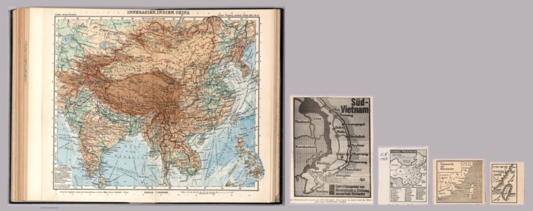
[Sydow, Emil von., 1812-1873, Wagner, Hermann, 1840-1929]
Full Title
Innerasien, Indien, China. Gotha : Justus Perthes. Sydow-Wagners method. Schul-Atlas. XXIII.
List No
13559.129
Note
Map of Inner Asiaian countries. Bonne'sche Projektion. Map accompanied by newspaper clippings: China Provinzen, Taiwan. Fukienstrasse mit Kusteninseln. Sud Vietnam.
Author
Brue, Adrien Hubert, 1786-1832
Full Title
Carte generale des Indes en-deca et au-dela du Gange, par A.H. Brue. A Paris, Chez l'Auteur ... 1821. (to accompany) Atlas physique et politique des cinq parties du monde, par H. Brue.
List No
13565.031
Note
Outline hand color engraved map of Turkey in Asia. In upper right margin: "Atlas Universel Pl. 28." Includes color coded reference.
Author
[Pasa, Ali Seref, Esref, Hafiz Ali]
Full Title
Hendochini ; Siam = Indochina; Thailand. 1311 (1895). Tabie ve Nnashiri Hasan Ferid. (to accompany) Yeni cografya atlasi - ىگى جغرافىا آطلسى = New geographical atlas. Dersa'adet (Istanbul), 1307-1309 (1891-1893).
List No
13621.028
Note
Map of the part of Southeast Asia. Including Indochina Peninsula, Thailand and Burma.
Author
[Baranov, Anatolij Nikolaevič, Soviet Union. Glavnoe upravlenie geodezii i kartografii]
Full Title
Индокитай = Indokitaĭ. 167-168. Atlas Mira : 1954.
List No
13682.181
Note
Physical map of Indochina. Showing political boundaries. Relief shown by gradient tints, contours and spot heights. Depth shown by bathymetric tints, isolines and soundings.
Author
[Weekly Dispatch, Weller, Edward, 1819-1884]
Full Title
Burmah, Siam, Anam &c. / by Edwd. Weller ; engraved by Edwd. Weller, 34, Red Lion Square ; E. Weller, Lithogr.
List No
14360.205
Note
Map of Burmah [current-day Myanmar], Siam [current-day Thailand], and Anam [current-day Vietnam]. Shows political boundaries, cities, topography, bodies of water, drainage, coastlines and islands. Relief shown with hachures. Includes latitudinal and longitudinal lines, as well as a legend and two bar scales given in English and geographical miles. Hand-colored lithograph. Map is 44 x 29 cm, on sheet 48 x 33 cm. Plate number handwritten in ink at upper right corner of sheet; "2/2/62" in pencil at bottom of sheet. Appears in Vol. II : Foreign.
Author
Elwe, Jan Barend
Full Title
1 Partie de la nouvelle grande carte des Indes Orientales, contenant les Terres du Mogol, Surate, Malabar, Cormandel, Bengale, Aracan, Pegu, Siam, Camboje, Tonquin, & une partie de la Chine dressée avec soin, sur pluseurs cartes manuscrites, par un habile connoisseur; & publiée a Amsterdam par Jan Bt. Elwe. MDCCXCII.
List No
14478.044
Note
Map of Asia, including the Mughal Empire [current-day India, Pakistan and Afghanistan], the Malabar, Coromandel, Bengal and Aracan regions, Siam [current-day Thailand], Camdodia, Tonquin [current-day Vietnam] and China. Shows countries, regions, cities, topography, vegetation, bodies of water, drainage, coastlines and islands. Relief shown pictorially. Includes a compass rose with north oriented toward top of sheet, four bar scales, latitudinal and longitudinal lines, and descriptive notes throughout. Hand-colored engraving. Map is 49 x 59 cm, on double sheet 58 x 70 cm. First of four sheets.
Author
[Hughes, William, 1818-1876, Bartholomew, John, 1831-1893]
Full Title
East Indian archipelago, Burmah, Siam, &c. By J. Bartholomew, F.R.G.S. George Philip & Son, London & Liverpool.
List No
14487.029
Note
Map representing Southeast Asia. Shows political boundaries, cities, topography, roads, bodies of water, drainage, and coastlines. Relief shown with hachures. Includes latitudinal and longitudinal lines, as well as bar scales given in English miles, geographical miles, and kilometers. With one inset map: Continuation of the eastern provinces, (further India). With: Explanation of colours. Colored lithograph. Map is 62 x 51 cm, on double sheet 70 x 56 cm.
Author
Arrowsmith, John, 1790-1873
Full Title
Burmah, Siam, and Cochin China, by J. Arrowsmith. London. Pubd. 25 Feby. 1858, by J. Arrowsmith, 10 Soho Square.
List No
14506.065
Note
Map representing current-day Myanmar, Thailand, Laos, Cambodia, Vietnam, Bangladesh, with part of Bhutan and Southeast China. Shows political boundaries, cities, roads, topography, bodies of water, drainage, coastlines, and islands. Relief shown with hachures. With notes on colonization. Includes latitudinal and longitudinal lines, as well as bar scales given in geographical and English miles. Hand-colored engraving. Map is 61 x 48 cm, on double-sheet 67 x 56 cm.
Author
Bartholomew, John
Full Title
(Index to) Burma Thailand Indo-China. Conic Projection. Standard Parallels 10 (degree) and 26 (degree) N. 1:4,000,000.
List No
1552.065
Note
Uncolored index map. Key to adjoining areas.
Author
Bartholomew, John
Full Title
Burma Thailand Indo-China. Edited by John Bartholomew, M.C., LL.D. The Geographical Institute Edinburgh. Copyright, John Bartholomew & Son, LTD.
List No
1552.066
Note
Full color map. With two inset maps: continuation of map on same scale, showing Thailand, Malaya, and India. Relief shown by gradient tints and spot heights in feet. Depth shown by shadings and soundings in meter. No. 1591, and Jan. 58, marked on the lower corners of plate. The Times Atlas on the upper left corner. Prime meridian is Greenwich.
Author
Blackie, W.G.
Full Title
Burmah, Siam, and Anam.
List No
1589.056
Author
USSR (Union of Soviet Socialist Republics).
Full Title
131-132. Indochina. The World Atlas.
List No
1603.143
Author
[Colton, G.W., Fisher, Richard Swainson]
Full Title
Asia (Southern sheet).
List No
1690.241
Note
Relief shown by hachures.
Author
Debenham, Frank
Full Title
Suez to Siam. (Copyright) G.P. Ltd. (with inset map) A little-known view of the lands ringing the Indian Ocean ...
List No
1794.036
Note
Color relief maps. Relief shown by gradient tints and spot heights. Inset view showing pipe-line from distant oil wells ...
Author
Hammond, C.S.
Full Title
India, East including Burma (Myanmar), Siam (Thailand), and French Indo-China (Vietnam). 19.
List No
1954.044
Author
Institute of Social and Religious Research
Full Title
Plate 8. Farther India and East Indies - Western Section. (insets) Java. Sumatra. Nias.
List No
2030.032
Author
[Geographisches Institut (Weimar, Germany), Kiepert, Heinrich, 1818-1899, Weiland, Carl Ferdinand, 1782 -1847]
Full Title
Hinter Indien nebst den Hinterindischen Inseln, entworfen und gezeichnet von C.F. Weiland, theilweise umgearbeitet und berichtigt von H. Kiepert. Weimar, im Verlage des Geograph: Instituts, 1855.
List No
2077.049
Note
Engraved map. Outline hand col. Relief shown by hachures.
Author
[Bartholomew, J. G. (John George), 1860-1920, John Bartholomew & Co.]
Full Title
Farther India. (with Andaman and Nicobar Islands). (with Singapore Strait Region). (with Singapore Region). The Edinburgh Geographical Institute, John Bartholomew & Co. "The Times" atlas. (London: The Times, 1922)
List No
2113.068
Note
Col. map with 4 insets. Relief shown by hypsometric tints and spot heights; depths by bathymetric tints. Shows shipping routes with distances, etc. Singapore Strait map at 1:2,000,000, Singapore at 1:150,000.
Author
[Instituto Geographico di Agostini, Bayer, Herbert]
Full Title
Indochina. (insets) Tonchino (North Vietnam), Bangkok, and Singapore.
List No
2170.071
Note
Relief shown as combined hachures, shaded relief, and hypsometric tints; bathymetry also tinted.
Author
[Instituto Geographico di Agostini, Bayer, Herbert]
Full Title
Cina. Cina, Indocina, Corea.
List No
2170.074
Note
Series of small maps showing, crops, minerals, land cover, products, and energy resources. Flags also shown.
Author
Vandermaelen, Philippe, 1795-1869
Full Title
Partie de l'Empire Birman. Asie no. 96. Dressee et dessee. par Ph. Vandermaelen. La lettre par Fois. Charles. Dessinee sur pierre et Lithogrie. par H. Ode. Juillet 1825. (Deuxieme partie. - Asie. Bruxelles. 1827)
List No
2212.128
Note
Hand col. lithographed map. Relief shown by hachures. Covers also part of northern Thailand. Prime meridian: Paris.
|