|
Author
[Wytfliet, Corneille, Magini, Giovanni Antonio]
Full Title
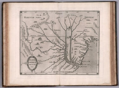
Plata Americae provincia. (to accompany) Histoire universelle des Indes occidentales et orientales, et de la conversion des Indiens : divisee en trois parties par Cornille Wytfliet & Anthoine Magin & autres historiens. Premiere Partie. A Douay, Chez Francois Fabri, l'An 1611.
List No
11622.020
Note
Uncolored engraved double page map of the Rio de la Plata region. Covers Argentina, Uruguay and the southern part of Brazil. Shows cities, towns, landmarks, rivers, capes, bays and mountains. Relief shown pictorially. Includes decorative title cartouche.
Full Title
Viceroyalty of La Plata. (Boston: Published by Thomas & Andrews. 1812)
List No
0028.057
Note
Engraved map, uncolored. Relief shown by hachures. Shows settlements, rivers, etc. Covers present-day Uruguay, Paraguay and parts of Argentina, Chile, Bolivia, Peru and Brazil. List of maps indicates map is new to this edition.
Author
Arrowsmith, John
Full Title
This map of the United Provinces of La Plata, the Banda Oriental, & Chile, is drawn principally from M.S.S. furnished by Woodbine Parish, Esqr., F.R.S., many years H.M. Consul General & Charge d'Affaires at Buenos Ayres, to whom it is dedicated by his obliged servant J. Arrowsmith. London, pubd. 15 Feby. 1834 by J. Arrowsmith, 35 Essex Street, Strand.
List No
0036.050
Note
Engraved map. Hand colored boundaries. Relief shown by hachures. Shows settlements, roads, Indian tribes, etc. Includes Paraguay and parts of Bolivia and Brazil.
Author
Brue, Adrien Hubert, 1786-1832
Full Title
Carte generale du Perou, du Haut-Perou, du Chili et de La Plata; dressee par A. Brue, Geographe du Roi ... Paris, 1826. Chez l'Auteur, rue des Macons-Sorbonne, no. 9, et chez les principaux m(archan)ds de cartes geographiques.
List No
0096.065
Note
Hand colored engraved map. Relief shown by hachures. Prime meridian: Paris.
Author
Lizars, Daniel
Full Title
Bolivia or Upper Peru; Chili and the United Provinces of South America or La Plata. Published by D. Lizars, Edinburgh. (1831?)
List No
0436.065
Note
Hand colored engraved map. Relief shown by hachures. Shows settlements, roads, rivers, etc. Includes inset.
Author
Lizars, William Home, 1788-1859
Full Title
Bolivia or Upper Peru; Chili and the United Provinces of South America or La Plata. Published by W. Lizars, Edinburgh. (to accompany) Lizars' Edinburgh Geographical General Atlas ... 1841.
List No
0438.080
Note
Double page engraved hand colored in outline, with inset: Continuation of map. Shows political boundaries, cities, towns, rivers and mountains. Relief shown by hachures. Prime meridian is Greenwich.
Author
Pinkerton, John, 1758-1826
Full Title
La Plata. Drawn under the direction of Mr. Pinkerton by L. Hebert. Neele sculpt. 352 Strand. London: published Jany. 25th. 1812 by Cadell & Davies, Strand & Longman, Hurst, Rees, Orme, & Brown, Paternoster Row.
List No
0732.051
Note
Engraved map. Full hand col. Relief shown by hachures. Shows tribes, geographic notes, etc. Covers Paraguay and Uruguay and portions of Argentina, Chile, Brazil and Bolivia. "Pinkerton's modern atlas."
Author
Polish Army Topography Service
Full Title
Southern South America. (inset) Montevideo. (inset) Valparaiso. (inset) Santiago. (inset)Buenos Aires. Pergamon World Atlas. Pergamon Press, Ltd. & P.W.N. Poland 1967. Sluzba Topograficzna W.P.
List No
0737.217
Note
Detailed physical and political map.
Author
[Stieler, Adolf, Habenicht, H., Salzmann, H., Petermann, A.]
Full Title
Nr. 97. Sued-Amerika, Bl. 3. ... von H. Habenicht und H. Salzmann.
List No
0962.211
Author
[Stieler, Adolf, Habenicht, H., Petermann, A, Petermann, A.]
Full Title
Nr. 99. Sued-Amerika, Bl. 5. ... H. Habenicht. (insets) Panama. Valparaiso. Santiago. Lima.
List No
0962.215
Author
[Stieler, Adolf, Habenicht, H., Petermann, A, Petermann, A.]
Full Title
Nr. 100. Sued-Amerika, Bl. 6. ... von H. Habenicht.
List No
0962.217
Author
Fer, Nicolas de, 1646-1720
Full Title
Partie la plus meridionale de l'Ame��rique, ou se trouve le Chili, le Paraguay, et les terres Magellaniques avec les fameux detroits de Magellan et de le Maire : Dresse��e sur diverse me��moires et re��lations des filibustiers et fameux voyageurs
List No
10022.108
Author
Monte (Monti), Urbano, 1544-1613
Full Title
Tavola XXXX. Che Ha Sua Superiore La Tavola. XXIII. Libro Terzo.
List No
10130.042
Author
شكوفه مقبل [Şukufe Mukbil]
Full Title
(South America with Railroads)
List No
10992.045
Note
Dimensions are sheet size. Has flag of Argentina on opposite page.
Author
[Andriveau-Goujon, J., Brue, Adrien Hubert, 1786-1832]
Full Title
Carte generale du Perou, du Haut-Perou, du Chili et de La Plata; dressee par A. Brue, Geographe du Roi ... Paris, 1826. Chez l'Auteur, rue des Macons-Sorbonne, no. 9, et chez les principaux m(archan)ds de cartes geographiques. (to accompany) Atlas de choix ou Recueil de cartes de geographie ancienne et moderne.
List No
11124.043
Note
Outline hand color engraved map. Shows political boundaries, towns, villages, roads, etc. Relief shown by hachures. Prime meridian is Paris. Includes text and color coded reference.
Author
[Lattre, Jean, 1743 -1793, L'Isle, Guillaume de, 1675-1726, Buache, Philippe]
Full Title
Carte du Paraguay, du Chili, du Detroit de Magellan &c. Dressée sur les Descriptions des P. P. Alfonse d'Ovalle, et Nicolas Techo et sur les Relations et memoires de Brouwer, Narbouroug, Mr. de Beauchesne & Par Guillaume De L'Isle ... 1703. Gravee par Liebaux le fils ... C. Simonneau inv. et fecit. Ph. Buache P.G.d.R. d. l'A. R.d.S. Gendre de l'Auteur. Avec Privilege du 30 Av. 1745. (to accompany) Atlas Geographique contenant la Mappemonde et les quatre parties, avec les differents Etats, avec apprpbation & privilage du Roy MDCC.LXIII (1763).
List No
11335.047
Note
Engraved outlined hand color map. Includes place names, and ornamental title cartouche. Relief shown pictorially.
Author
[Meyer, Joseph, 1796-1856, Radefeld, Carl Christian Franz, 1788-1874, Adam, Jean]
Full Title
Die Sudspitze von Sud America mit Patagonia.1850. Entworfen u. gez. v. Major Radefeld. Jean Adam sc. (in upper margin) Meyer's Zeitung Atlas. No. 116. (to accompany) Neuester Zeitungs-Atlas fur Alte und Neue Erdkunde. Herausgegeben von J. Meyer. (insets) Insel Georgia. (with) Die Sud-Schetland und Orkney I.n.
List No
11652.104
Note
Engraved outline hand color map. Shows boundaries, cities and towns. Relief shown by hachures.
Author
[Santini, Paolo, d'Anville]
Full Title
53. Carte du Chili Meridional, du Rio de la Plata, des Patagons, et du Detroit ... l'Amerique Meridionale.
List No
12039.136
Author
[Stieler, Adolf, Petermann, A.]
Full Title
92. Sued-Amerika in 6 Blaettern, Bl. 3.
List No
12240.109
Author
[Stieler, Adolf, Petermann, A.]
Full Title
94. Sued-Amerika in 6 Blaettern, Bl. 5. (insets) Santiago. Lima, Callao. Valparaiso.
List No
12240.111
Author
[Schraembl, Franz Anton, D'Anville]
Full Title
24. Karte von Sued-America (southern sheet), Ferfasst von Herrn d'Anville, Geographen des Koenig von Frankreich, Nach den neuesten Entdeckungen verbessert herausgegeben von Herrn F.A. Schraembl. MDCCLXXXVI.
List No
12498.043
Author
[Schraembl, Franz Anton, D'Anville]
Full Title
25. Karte von Sued-America (central sheet), Ferfasst von Herrn d'Anville, Geographen des Koenig von Frankreich, Nach den neuesten Entdeckungen verbessert herausgegeben von Herrn F.A. Schraembl. MDCCLXXXVI.
List No
12498.044
Author
[Lapie, Pierre, M. 1779-1850, Lapie, Alexandre Emile]
Full Title
Carte de la Plata, du Chili, et de la Patagonie. Dressee par Mr. Lapie, Colonel d'Etat Major, et M. Lapie fils, Chef d'Escon. au meme Corps. Paris,1851. Chez P. C. Lehuby. Grave par P. Tardieu. Frault Jne. Imp. Paris. (to accompany) Atlas Universel de Geographie ancienne et moderne ...1851.
List No
13244.056
Note
Engraved map. Outline hand color. Covers: Iles Shetland Meridionales; Iles Falkland; Ile Georgie; Iles Oreades ou Powell. Relief shown by hachures. Prime meridian is Paris. In upper left margin: Atlas universel.
Author
[Sydow, Emil von., 1812-1873, Wagner, Hermann, 1840-1929]
Full Title
Rio de Janeiro. Buenos Aires. Lima. Gotha : Justus Perthes. Sydow-Wagners method. Schul-Atlas. XXII.
List No
13558.148
Note
3 city plans on 1 sheet.
Author
[Sydow, Emil von., 1812-1873, Wagner, Hermann, 1840-1929]
Full Title
Rio de Janeiro. Buenos Aires. Lima. Gotha : Justus Perthes. Sydow-Wagners method. Schul-Atlas. XXIII.
List No
13559.156
Note
3 city maps on 1 sheet.
Author
Brue, Adrien Hubert, 1786-1832
Full Title
Carte generale du Perou, du Haut-Perou, du Chili et de La Plata, dressee par A. Brue ... Paris. 1826. Chez l'Auteur. (to accompany) Atlas physique et politique des cinq parties du monde, par H. Brue.
List No
13565.044
Note
Supplementary Pl. 64, from Atlas de l'Afrique "Outline hand color engraved map. Includes color coded reference to European possessions in the region and text.
Author
[3, Soviet Union. Glavnoe upravlenie geodezii i kartografii]
Full Title
Среднее Чили. Центральная Аргентина (Пампа) = Sredneye Chili. Tsentral'naia Argentina (Pampa). 265. Atlas Mira : Moskva 1954.
List No
13682.278
Note
Map of Central Argentina (Pampa), with inset: Central Chile. Relief shown by gradient tints and spot heights. Depths shown by bathymetric tints, isolines and soundings.
Full Title
Sudamerika sudliches Blatt. (with) Chile. (with) Sudost-Brasilien mit den Deutschen Colonien und Uruguay. (Richard Andree. Herausgegeben von der Geographischen Anstalt von Velhagen & Klasing in Leipzig. 1881)
List No
1494.064
Note
Colored map. Relief shown by hachures and spot heights. Shows cities, rivers, etc. "II.1881."
Author
Greenleaf, Jeremiah
Full Title
Buenos Ayres, Chili & Patagonia.
List No
15176.067
Note
Full color by provinces. Engraved. Relief shown by hachures. Meridians Greenwich and Washington.
Author
[U.S. Coast and Geodetic Survey, U.S. Army Air Forces]
Full Title
Argentina
List No
15328.032
Author
USSR (Union of Soviet Socialist Republics).
Full Title
(Map Title Page) 230-231. South America, South. 232. Chile, Central; Argentina, Central (Pampa).
List No
1603.241
Author
[Bartholomew, J. G. (John George), 1860-1920, John Bartholomew & Co.]
Full Title
Argentina, Chile, &c. The Edinburgh Geographical Institute, John Bartholomew & Co. "The Times" atlas. (London: The Times, 1922)
List No
2113.118
Note
Col. map. Relief shown by hypsometric tints and spot heights; depths by bathymetric tints. Shows shipping routes with distances, etc. Includes inset.
Author
Bradford, Thomas G.
Full Title
(Text Page to) Argentine Republic or State of Plata. (to accompany) A Comprehensive Atlas, Geographical, Historical & Commercial. By T.G. Bradford. Boston: American Stationers' Company. Entered ... 1835, by Thos. G. Bradford ... Massachusetts.
List No
2120.084
Note
Text includes major cities in each country, population, physical feature, etc. covers Argentina, Republic of Uruguay, Dictatorate of Paraguay, Chile and Patagonia.
Author
Bradford, Thomas G.
Full Title
United Provinces : Chile & Patagonia. (to accompany) A Comprehensive Atlas, Geographical, Historical & Commercial. By T.G. Bradford. Boston: American Stationers' Company. Entered ... 1835, by Thos. G. Bradford ... Massachusetts.
List No
2120.085
Note
Color map. Shows political boundaries, regions, cities and towns, rivers, etc. Relief shown by by hachures and pictorially. Prime meridians are Washington and Greenwich.
Author
[Lapie, Alexandre Emile, Lapie, M. (Pierre), 1779-1850]
Full Title
Carte de la Plata, du Chili, et de la Patagonie. Dressee par M. Lapie, 1er. Geographe du Roi et M. Lapie Fils, Lieutenant Ingenieur Geographe. Paris, 1828. Chez Eymery Fruger et Cie., Rue Mazarine No. 30. Dirigee et gravee par Lallemand.
List No
2174.050
Note
Engraved map. Outline hand color. Relief shown by hachures. Covers also the Falkland, South Orkney, South Shetland and South Georgia islands. Prime meridian: Paris.
Author
[Jones, C.H., Hamilton, T.H., Williams, J.David]
Full Title
Southern States of America, La Plata, Chili (Chile), Paraguay, Uruguay (Uraguay), & Patagonia.
List No
2307.032
Author
Mitchell, Samuel Augustus Jr., 1792-1868
Full Title
Chile, Paraguay, The Argentine Confederation and Uruguay. (to accompany) Mitchell's New Reference Atlas for the Use of Colleges, Libraries, Families and Counting Houses. Philadelphia: Published By E.H. Butler & Co. 1865.
List No
2516.025
Note
Hand colored map. Relief shown by hachures. Showing political and administrative divisions, major cities, rivers and mountains. Prime meridians are Greenwich and Washington.
Author
Bradford, Thomas G.
Full Title
United Provinces : Chile & Patagonia. (to accompany) A Comprehensive Atlas, Geographical, Historical & Commercial. By T.G. Bradford. William D. Ticknor, Boston. Wiley & Long, New-York. Entered ... 1835, by Thos. G. Bradford ... Massachusetts.
List No
2643.086
Note
Outline color map by country and region. Shows cities and towns, rivers, etc. Relief shown pictorially. Prime meridians are Washington and Greenwich.
Author
Carey, Mathew
Full Title
Chili And Part Of The Viceroyalty Of La Plata. Lewis delin. W. Robinson Sc.
List No
2721.040
Note
Outline color by region. Relief shown by hachures. Prime meridians Philadelphia and London.
Author
Johnston, W. & A.K.
Full Title
South America (southern sheet). (with) Valparaiso and Environs. (with) Valparaiso. (with) Buenos Aires. (with) Rio de Janeiro and Environs. (with) Rio de Janeiro Harbour. Keith Johnston's General Atlas. Dec. 1911. Engraved, Printed, and Published by W. & A.K. Johnston, Limited, Edinburgh & London.
List No
2763.065
Note
Countries and provinces outlined in color. Relief shown by hachures. Three scales. Four insets.
Author
Greenleaf, Jeremiah
Full Title
Buenos Ayres, Chili & Patagonia.
List No
2866.063
Note
Full color by provinces. Engraved. Relief shown by hachures. Meridians Greenwich and Washington.
Author
Johnson, A.J.
Full Title
Johnson's Brazil, Argentine Republic, Paraguay And Uruguay. By Johnson & Browning. (with) two inset maps: Rio De Janeiro and Pernambuco. No. 55.
List No
2905.037
Note
In full color. View of the harbor of Rio De Janeiro.
Author
Fenner, Rest.
Full Title
Peru, Chili, La Plata &c. Fenner Sc., Paternoster Row. (London, Joseph Thomas, 1835)
List No
3362.069
Note
Engraved map. Outline hand coloring. Relief shown by hachures.
Author
Hall, S. (Sidney)
Full Title
Chili, La Plata, and Bolivia or Upper Peru by Sidney Hall. London, published by Longman, Rees, Orme, Brown & Green, Paternoster Row, Feby. 1, 1829.
List No
4224.054
Note
Engraved map. Boundaries hand col. Relief shown by hachures. Covers also Uruguay and parts of Paraguay and Brazil. Also numbered LIII.
Author
Lucas, Fielding Jr.
Full Title
United Provinces. B.T. Welch & Co. Sc. Drawn & Published by F. Lucas Jr. Baltimore.
List No
4584.099
Note
Full color by region.
Full Title
Amerique Meridionale 3e. feuille. (Dediee et presentee a Monsieur. Par H. Brue, Ingenieur-Geographe de S.A. Royale). Dirige par H. Brue. (A Paris, Chez Desray ... (et) Goujon ..., 1816)
List No
4614.041
Note
Engraved map. Outline hand col. SE sheet. Relief shown by hachures. Prime meridian: Paris. "Atlas universel no. (34)."
Full Title
Amerique Meridionale 4e. feuille. (Dediee et presentee a Monsieur. Par H. Brue, Ingenieur-Geographe de S.A. Royale. Dirige par H. Brue. A Paris, Chez Desray ... (et) Goujon ..., 1816)
List No
4614.042
Note
Engraved map. Outline hand col. SE sheet. Relief shown by hachures. Includes inset map of Patagonia and Tierra del Fuego and the Falkland Islands (continuation of map). Prime meridian: Paris. "Atlas universel no. (35)."
Full Title
(Sud-America) Sud-Amerika. No. III. (Nach den neuesten u. besten Materialien bearbeitet u. gezeichnet von F. Handtke. Druck u. Verlag v. C. Flemming. Glogau, 1854. 1855)
List No
4765.101
Note
Hand colored lithographed map. South sheet (3 of 3). Relief shown by hachures. Includes elevation table. Prime meridian: Ferro.
Author
Meyer, Joseph, 1796-1856
Full Title
Die Republiken Chili, La Plata und Uruguay, 1853. (with) Sudl. Theil von Patagonia. H.S(chleifmann sculp). Stahlstich, Druck u. Verlag des Bibliographischen Instituts in Hildburghausen, (1860)
List No
4807.173
Note
Engraved map. Boundaries hand col. Relief shown by hachures. Scale of inset map (ca. 1:17,000,000). "Meyer's Hand-Atlas No. 148." Prime meridian: Washington.
Author
Meyer, Joseph, 1796-1856
Full Title
Sudlichster Theil von America enthaltend Bolivia, das sudliche Brasilien, Paraguay, Chile, La Plata, Cisplatina und Patagonien. 1834. Stich, Druck und verlag der geographischen Anstalt des Bibliographischen Instituts ... (In upper margin) Meyer's Atlas in 64 Karte. No. 46. (to accompany: Meyer's Zeitungs und Groschen Atlas aller Lander und Staaten der Erde). (insets) Patagonien. (with) Falklands I.
List No
4808.074
Note
Engraved outline hand color map. Shows boundaries, towns and place names. Relief shown by hachures. Includes explanation and list of provinces. Prime meridian is Ferro.
|