|
Author
Arrowsmith, John, 1790-1873
Full Title
Official map of railways in England and Scotland, shewing the existing lines & those in progress; from the maps prepared, by the authority of the Commissioners of Railways; (presented to both houses of parliament) and from the other documents; by John Arrowsmith. 1858. London, pubd. July 1st, 1858, by J. Arrowsmith, 10 Soho Square.
List No
14506.014
Note
Composite map of railways in England and Scotland. Shows counties, cities, railways, bodies of water, drainage, coastlines and islands. Relief shown with hachures. Includes a legend, latitudinal and longitudinal lines, as well as a bar scale given in English miles. Hand-colored engraving. Hand-colored engraving. All together, map is 106 x 67 cm, on two double sheets, together 68 x 112 cm.
Author
[Depot General de la Marine, Downie, Murdo]
Full Title
Carte Particuliere De La Cote Orientale D'Ecosse depuis St. Abb's Head jusqu'a Duncansby Head
List No
15934.049
Note
Hydrographie Française 2
Author
Depot General de la Marine
Full Title
Carte Particuliere De La Cote Occidentale D'Ecosse, depuis la Pointe d'Ardnamurchan jusqu'au Mull de Galloway
List No
15934.090
Note
Hydrographie Française 2 Printed on blue paper.
Author
Depot General de la Marine
Full Title
Carte Particuliere De La Cote Occidentale D'Ecosse, depuis le Cap Wrath jusqu'a la Pointe d'Ardnamurchan
List No
15934.091
Note
Hydrographie Française 2
Author
Depot General de la Marine
Full Title
(North Sheet) Carte Reduite De La Mer Du Nord.
List No
15934.004
Note
Hydrographie Française 1
Author
Depot General de la Marine
Full Title
(Composite map of) (North and South Sheets) Carte Reduite De La Mer Du Nord.
List No
15934.006
Note
Hydrographie Française 1
Author
[Depot General de la Marine, Lowenorn, M.]
Full Title
Carte Des Iles Shetland
List No
15934.046
Note
Hydrographie Française 1
Author
Depot General de la Marine
Full Title
Carte Des Isles Orcades Et De La Cote Nord D'Ecosse
List No
15934.047
Note
Hydrographie Française 1
Author
Greenleaf, Jeremiah
Full Title
Scotland. (with) two inset maps: Shetland Isles and Orkney Isles.
List No
15176.011
Note
Engraved. Relief shown by hachures. In full color by county. Railroads shown. Insets of Orkney and Shetland Isles. Meridians Greenwich and Washington.
Author
Desilver, Roberto
Full Title
Escosia.
List No
14368.009
Note
Map of Scotland. Shows political boundaries, cities, topography, bodies of water, drainage, coastlines and islands. Relief shown with hachures. Includes latitudinal and longitudinal lines, as well as a bar scale and compass rose with north oriented toward top of sheet. With inset map: Islas de Setlanda. Hand-colored engraving. Map is 37 x 31 cm, on double sheet 55 x 45 cm.
Author
[Raif Efendi, Mahmud, Faden, William (1749-1836)]
Full Title
(Scotland)
List No
15054.054
Note
For the source map by Faden see https://www.davidrumsey.com/luna/servlet/s/g034r8
Author
[Morden, Robert, approximately 1650-1703, Cockerill, Thomas, active 1674-1702]
Full Title
(Text Page to) Of Europe (2) -- Of the British Isles (1).
List No
14323.015
Note
On left - descriptive text for map, Europe, on prior page (9). Text spans pages 9-12. In addition, on left - map of the British Isles. Map includes title cartouche: England, Scotland & Ireland, by Robt. Morden. Shows political boundaries, cities, topography, drainage, coastlines and islands. Relief shown pictorially. Contains latitudinal and longitudinal lines. Map is 10 x 13 cm, on sheet 15 x 20 cm. With inset map featuring two of the Channel Islands: [Guernsey and Jersey]. On right - descriptive text for map, England, Scotland & Ireland. Text spans pages 13-28.
Author
Stieler, Adolf, 1775–1836
Full Title
(Composite to) Grossbritannien Im Maassstabe Von 1:1.500.000. Von A. Petermann. Bearb. v. Ernst Debes. Gest. v. Poppey u. Jungmann. Stieler's Hand-Atlas No. 46-47. Gotha: Justus Perthes 1875.
List No
13563.067
Note
1 map on 2 sheets. Outline color map of Great Britain. sheets 46-47.
Author
Willdey, George
Full Title
To His Sacred and most Excellent Majesty George By the Grace of God King of Great Britain, France & Ireland &c. : This Map of Great Britain and Ireland Corrected from the Newest & most Exact Observations is most humbly dedicated by ... George Willdey 1715.
List No
13539.010
Note
Engraved hand color in outline map, with uncolored decorative cartouches. Includes dedication text and insets: map of The Island of Sheltand, and part of Shetland Is., with Royal coat of arms, Portrait of Georgius I.us D.G. Magniae Britaniae Franc. et Hib. Rex, View of sailing ships and boats, ship with poem to King George. Includes annotations, compass rose and explanation.
Author
[Mercator, Gerhard, 1512-1594, Hondius, Jodocus, 1563-1612, Hondius, Hendrik, 1597-1651]
Full Title
Anglia, Scotia et Hibernia.
List No
10534.043
Author
[Mercator, Gerhard, 1512-1594, Hondius, Jodocus, 1563-1612]
Full Title
Anglia, Scotia et Hibernia.
List No
10501.067
Author
[Johnston, Alexander Keith, 1804-1871, Forbes, Edward]
Full Title
(Composite Map) Paleontological Map of the British Islands.
List No
12509.039
Author
Speed, John, 1542-1629
Full Title
The Kingdome of Great Britaine and Ireland.
List No
12058.014
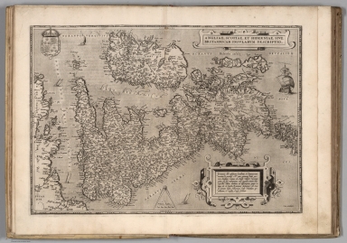
Author
Ortelius, Abraham, 1527-1598
Full Title
Angliae, Scotiae Et Hiberniae, Sive Britannicar: Insularum Descriptio. Cum Priuilegio. Britannia olim insularum Occidentis et Septentrionis maxima & potentiss.est.cuius potiorem hodie partem Angliam vocamus, ab Anglis videlicet Saxonum gente, quae sub Valentiniano eam ingressa, tenuit. Haec veteribus Albion dicebatur, ad differentiam, quum reliquae oês eò tractu Britannicae dicebantur. Ab Occasu vicinam habet Hiberniam, hodie Irlandiam appellatam; & regibus Angliae subditam.
List No
10000.021
Author
Appleton, D. & Co.
Full Title
Scotland. Copyright 1891 by Appleton & Co. (untitled insets) Glasgow; Edinburgh. (to accompany) The Library Atlas Of Modern Geography ... New York, D. Appleton And Company 1892. (on upper margin) Scotland 15.
List No
0026.025
Note
Color map on 2 sheets, with 2 insets. Shows administrative divisions, major cities, rivers, mountains, roads, railways, canals, battle fields, principal steam routes and distances from place to place. Relief shown by hachures. Spot heights in feet. Prime meridian is Greenwich.
Full Title
Scotland. From Genl. Roy's map corrected in positions and the surveys of the different shires. (Boston: Published by Thomas & Andrews. 1812)
List No
0028.005
Note
Engraved map, uncolored. Relief shown by hachures. Shows shires, cities, rivers, etc.
Author
Arrowsmith, John
Full Title
Scotland, by J. Arrowsmith. London, pubd. 15 Feby. 1834 by J. Arrowsmith, 35 Essex Street, Strand.
List No
0036.006
Note
Engraved map. County boundaries hand colored. Relief shown by hachures.
Author
Colton, G.W.
Full Title
Scotland. (with) two inset maps: Orkney Isles and Shetland Isles. Published By J.H. Colton & Co. No. 172 William St. New York. Entered ... 1855 by J.H. Colton & Co. ... New York. No. 5.
List No
0149.072
Note
In full color by county.
Author
Colton, G.W.
Full Title
Scotland. (inset) Orkney Isles. Shetland Isles. Published By J. H. Colton. No. 172 William St. New York.
List No
0151.077
Note
Prime meridians are Greenwich and Washington D.C. Relief shown by hachures.
Author
Colton, G.W.
Full Title
Scotland. (inset) Orkney Isles. and Shetland Isles. Published By G. W & C. B. Colton & Co. No. 172 William St. New York.
List No
0152.079
Note
Prime meridians are Washington D.C. and Greenwich.
Author
Cram, George Franklin
Full Title
Scotland.
List No
0210.066
Note
Prime meridians Greenwich and Washington.
Author
Delamarche, Felix
Full Title
Iles Britanniques ... 1824.
List No
0231.007
Author
[Dower, John, Higgins, W.M.]
Full Title
Scotland.
List No
0247.024
Author
Finley, Anthony
Full Title
Scotland. Young & Delleker Sc. Published by A. Finley, Philada. (to accompany) A New General Atlas Comprising a Complete Set of Maps, representing the Grand Divisions Of The Globe ... Philadelphia: Published by Anthony Finley. 1827.
List No
0282.044
Note
Full color map on sheet 35x27. Relief shown pictorially. Prime meridians are Washington and Greenwich. Shows administrative divisions, major cities and rivers.
Author
Finley, Anthony
Full Title
Scotland. Published by A. Finley Philada. Young & Delleker Sc.
List No
0285.041
Note
Full color.
Author
[Bowen, Emanuel, Gibson, John]
Full Title
Scotland. (to accompany) Atlas Minimus or a New Set of Pocket Maps of the Several Empires, Kingdoms and States of the Known World, with Historical Extracts relative to each. Drawn and Engraved by J. Gibson from the Best Authorities, Revis'd, Corrected and Improv'd by Eman: Bowen Geographer to His Majesty.
List No
0300.013
Note
First edition. The "Historical Extracts" are short bits of text printed on the maps giving relevant geographical information. A revised edition was published in London in 1792. In 1759, another edition was published adding separate geographical descriptions and correcting some of the maps (see our copy). The Philadelphia 1798 edition by Mathew Carey incorporates the 1759 edition text word for word (excepting the maps of United States which Carey omits in favor of his pocket atlas of the U.S.). Gibson and Bowen made the four sheet map of North America (Stevens 49), and Gibson made the four sheet map of America (Stevens 3).
Author
Johnson, A.J.
Full Title
Johnson's Ireland by Johnson and Ward. Johnson's Scotland By Johnson and Ward. (insets): Orkney Isles and Shetland Isles.
List No
0352.050
Note
In full color. Two maps enclosed in one decorative border. Explanatory keys show capital cities, cities and towns, rivers, canals, major roadways, railroads, and battle fields. Relief shown by hachures. Prime meridians are Greenwich and Washington D.C.
Author
Johnson, A.J.
Full Title
Johnson's Ireland. Entered ... 1867. Johnson's Scotland. Entered ... 1867. (inset) Shetland Isles.
List No
0358.055
Note
Scotland map at scale 1,370,000.
Author
Johnston, Alexander Keith, 1804-1871
Full Title
Scotland, northern sheet, by Keith Johnston, F.R.S.E. Engraved & printed by W. & A.K. Johnston, Edinburgh. William Blackwood & Sons, Edinburgh & London, (1861)
List No
0373.008
Note
Engraved map. County boundaries hand col.; hydrography, shipping lanes printed in blue. Relief shown by hachures and spot heights. Inset maps: Shetland Islands -- Fair I. "Keith Johnston's general atlas 7."
Author
Johnston, Alexander Keith, 1804-1871
Full Title
Scotland, southern sheet, by Keith Johnston, F.R.S.E. Engraved & printed by W. & A.K. Johnston, Edinburgh. William Blackwood & Sons, Edinburgh & London, (1861)
List No
0373.009
Note
Engraved map. County boundaries hand col.; hydrography, shipping lanes printed in blue. Relief shown by hachures and spot heights. Includes table of Scottish terms with English equivalent. "Keith Johnston's general atlas 8."
Author
Johnston, Alexander Keith, 1804-1871
Full Title
(Composite of) Scotland, northern sheet, by Keith Johnston, F.R.S.E. Engraved & printed by W. & A.K. Johnston, Edinburgh. William Blackwood & Sons, Edinburgh & London, (1861)
List No
0373.010
Note
Two engraved maps. County boundaries hand col.; hydrography, shipping lanes printed in blue. Relief shown by hachures and spot heights. Inset maps: Shetland Islands -- Fair I. Includes table of Scottish terms with English equivalent. "Keith Johnston's general atlas" 7-8.
Author
Johnston, Alexander Keith
Full Title
Scotland (northern sheet). (with) Shetland Islands. (with) Fair I. By Keith Johnston, F.R.S.E. Keith Johnston's General Atlas. Engraved, Printed, and Published by W. & A.K. Johnston, Edinburgh & London.
List No
0377.009
Note
Counties outlined in color. Relief shown by hachures. Teo insets. Three scales.
Author
Johnston, Alexander Keith
Full Title
Scotland (southern sheet). By Keith Johnston, F.R.S.E. Keith Johnston's General Atlas. Engraved, Printed, and Published by W. & A.K. Johnston, Edinburgh & London.
List No
0377.010
Note
Counties outlined in color. Relief shown by hachures. Three scales.
Author
Johnston, Alexander Keith
Full Title
(Composite of) Scotland. By Keith Johnston, F.R.S.E. Keith Johnston's General Atlas. Engraved, Printed, and Published by W. & A.K. Johnston, Edinburgh & London.
List No
0377.011
Note
Counties outlined in color. Relief shown by hachures. Three scales.
Author
Campbell, Robert, Lieutenant
Full Title
A new and correct map of Scotland or North Britain, with the post and military roads, divisions &ca. (Northern section). Drawn from the most approved surveys, illustrated with many additional improvements, and regulated by the latest astronomical observations by Lieut. Campbell. London, printed for Robt. Sayer, no. 53 Fleet Street, as the Act directs 10 Jany. 1790.
List No
0411.011
Note
Engraved map printed on 2 sheets comprising the northern half of the 4-sheet map. Counties in outline color. Shows classified roads with distances, etc. Relief shown pictorially. Inset map: The islands of Shetland or Zetland laid down on the same scale as the map. David Rumsey Collection sheets mounted together as one sheet.
Author
Campbell, Robert, Lieutenant
Full Title
(A new and correct map of Scotland or North Britain, with the post and military roads, divisions &ca. Southern section. Drawn from the most approved surveys, illustrated with many additional improvements, and regulated by the latest astronomical observations by Lieut. Campbell. London, printed for Robt. Sayer, no. 53 Fleet Street, as the Act directs 10 Jany. 1790)
List No
0411.012
Note
Engraved map printed on 2 sheets comprising the southern half of the 4-sheet map. Counties in outline color. Shows classified roads with distances, etc. Relief shown pictorially. Includes distance table. David Rumsey Collection sheets mounted together as one sheet.
Author
Campbell, Robert, Lieutenant
Full Title
(Composite of) A new and correct map of Scotland or North Britain, with the post and military roads, divisions &ca. Drawn from the most approved surveys, illustrated with many additional improvements, and regulated by the latest astronomical observations by Lieut. Campbell. London, printed for Robt. Sayer, no. 53 Fleet Street, as the Act directs 10 Jany. 1790.
List No
0411.013
Note
Engraved map printed on 4 sheets. Counties in outline color. Shows classified roads with distances, etc. Relief shown pictorially. Inset map: The islands of Shetland or Zetland laid down on the same scale as the map. Includes distance table. David Rumsey Collection sheets mounted together as 2 sheets. (W 8 30--W 1 00/N 60 50--N 54 35)
Author
Lizars, Daniel
Full Title
British Islands. Published by D. Lizars, Edinburgh. (1831?)
List No
0436.007
Note
Hand colored engraved map. Relief shown by hachures. Shows settlements, counties, roads and rivers.
Author
Lizars, Daniel
Full Title
Scotland. Published by D. Lizars, Edinburgh. (with) Shetland Isles. (1831?)
List No
0436.011
Note
Northern sheet. Hand colored engraved map. Relief shown by hachures. Shows settlements, counties, roads, rivers, etc.
Author
Lizars, Daniel
Full Title
Southern part of Scotland. Published by D. Lizars, Edinburgh. (1831?)
List No
0436.012
Note
Southern sheet. Hand colored engraved map. Relief shown by hachures. Shows settlements, counties, roads, rivers, etc.
Author
Lizars, Daniel
Full Title
(Composite of) Scotland. Published by D. Lizars, Edinburgh. (with) Shetland Isles. (1831?)
List No
0436.013
Note
Digital composite of 2 sheets. Hand colored engraved map. Relief shown by hachures. Shows settlements, counties, roads, rivers, etc. South sheet has title: Southern part of Scotland.
Author
Lizars, William Home, 1788-1859
Full Title
Scotland : With all the railways. Published by W.H. Lizars, Edinburgh. Samuel Highley, London & W. Curry junr. & Co, Dublin. (to accompany) Lizars' Edinburgh Geographical General Atlas ... 1841. (inset) Shetland Isles.
List No
0438.018
Note
1 map on 2 sheet, double page engraved hand colored in outline. Relief shown by hachures. Shows administrative boundaries, cities, roads, railroads, rivers and mountains. Prime meridian is Greenwich.
Author
Lizars, William Home, 1788-1859
Full Title
Scotland : With all the railways. Published by W.H. Lizars, Edinburgh. Samuel Highley, London & W. Curry junr. & Co, Dublin. (to accompany) Lizars' Edinburgh Geographical General Atlas ... 1841. (inset) Shetland Isles.
List No
0438.019
Note
1 map on 2 sheet, double page engraved hand colored in outline. Relief shown by hachures. Shows administrative boundaries, cities, roads, railroads, rivers and mountains. Prime meridian is Greenwich.
Author
Lizars, William Home, 1788-1859
Full Title
(Composite map) Scotland : With all the railways. Published by W.H. Lizars, Edinburgh. Samuel Highley, London & W. Curry junr. & Co, Dublin. (to accompany) Lizars' Edinburgh Geographical General Atlas ... 1841. (inset) Shetland Isles.
List No
0438.020
Note
Digital composite of sheets XII-XIII, 1 map on 2 sheet, double page engraved hand colored in outline.
Author
Malte-Brun, Conrad, 1775-1826
Full Title
Ecosse, 1831. No. 41. Grave par Thierry. (1837)
List No
0458.035
Note
Engraved map. Countries and districts trimmed in color. Rivers and lakes shown. Major relief shown by hachures. Includes 2 scales. Inset of the Iles Shetland.
|