|
Author
Andriveau-Goujon, Eugene
Full Title
Palestine ancienne & moderne, d'apres les sources les plus authentiques. Par E. Andriveau. Paris - 1862. E. Andriveau-Goujon. Rue du Bac. 21. Paris, Imprimie. de Louis Antoine. Grave le trait et les montagnes par Gérin; les Ecritures par P. Rousset. Les Eaux par Mme. Fontaine. (to accompany) Atlas classique et universel de geograparphie ancienne et moderne ... Nouvelle edition. 1863.
List No
13421.047
Note
Hand color map. Insets:Sinai -- Golfe de Suez -- Cross section of the Palestine from the source of the Jordan to the Red Sea -- Panoramic view of the mountains of Palestine -- Jeusalem d'apres le plan de G. Williams. Covers portions of Israel, Jordan, Syria and Lebanon. Shows roads and trails. Relief shown by hachures. Includes tables and text.
Author
Radó, Sándor, 1899-1981
Full Title
Der Friedensvertrag von Versailles -- Der Friedensvertrag von Lausanne -- Der Friedensvertrag von Neuilly.
List No
14253.020
Note
Three political maps of Europe and the Middle East, in black and white, showing the international boundaries established by the peace treaties of Versailles [1920], Lausanne [1923] and Neuilly [1912/13]. Each map includes a legend and a bar scale. Scale of each map, respectively: 1:6,250,000 -- 1:41,666,667 -- 1:5,555,556. Titles beneath each map, translate to: The Peace Treaty of Versailles -- The Peace Treaty of Lausanne -- The Peace Treaty of Neuilly. Together, maps are 31 x 23 cm, on sheet 26 x 34 cm. Accompanied by descriptive text on facing page.
Author
[Sydow, Emil von., 1812-1873, Wagner, Hermann, 1840-1929]
Full Title
Vorderasien und Agypten. Gotha : Justus Perthes. Sydow-Wagners method. Schul-Atlas : 21 Auflage. 1940.
List No
13557.121
Note
Map of Middle East and Egypt. With inset: Frz. Somali. Bonne'sche Projektion.
Author
Brue, Adrien Hubert, 1786-1832
Full Title
Palestine ou Terre Sainte : par M. Mentelle et P.G. Chanlaire ... Grave par P.F. Tardieu. (to accompany) Atlas physique et politique des cinq parties du monde, par H. Brue.
List No
13565.005
Note
Engraved outline color map, with inset: La Terre de Chanaan avant les conquetes de Josue.
Author
Brue, Adrien Hubert, 1786-1832
Full Title
La Palestine, par le Sr D'Anville. MDCCLXVII (1767). (to accompany) Atlas physique et politique des cinq parties du monde, par H. Brue.
List No
13565.006
Note
Unnumbered, supplementary plate. Engraved outline color map, with insets: Les Tribus. Jerusalem. Positions determinees par des Distances donnees.
Author
[U.S. Coast and Geodetic Survey, U.S. Army Air Forces]
Full Title
Iran
List No
15328.002
Author
Sanson, Nicolas, 1600-1667
Full Title
Estats de L'Empire du Grand Seigneur des Turqs ou Sultan des Ottomans en Asie en Afrique, et en Europe
List No
15185.054
Author
[Ptolemy, Claudius, Mercator, Gerhard, 1512-1594, Pirckheimer, Willibald, Mylius, Arnold]
Full Title
ASIAE: VII. TAB
List No
10991.203
Note
Hand colored outline map of Central Asia and Middle East. Relief shown pictorially.
Author
[Pasa, Ali Seref, Esref, Hafiz Ali]
Full Title
(Composite Map) تفصیلات ولایات شاهانه = Details of the royal States. 1314 (1898). Tabie ve Nnashiri Hasan Ferid. (to accompany) Yeni cografya atlasi - ىگى جغرافىا آطلسى = New geographical atlas. Dersa'adet (Istanbul), 1307-1309 (1891-1893).
List No
13621.044
Note
Composite map of Ottoman Empire on 6 sheets. Covers Mediterranean region and Balkan States, from Black Sea to Adriatic Sea and part of Europe.
Author
[Lizars, William Home, 1788-1859, Lizars, Daniel]
Full Title
Arabia. Published by T. Brown & W. & D. Lizars, Edinburgh. (to accompany) New Edinburgh general atlas ... The maps drawn and engraved by W. & D. Lizars.
List No
13230.042
Note
Hand colored in outline engraved map. Shows political and administrative boundaries. Relief shown by hachures.
Author
[Lizars, William Home, 1788-1859, Lizars, Daniel]
Full Title
Persia. Published by T. Brown & W. & D. Lizars, Edinburgh. (to accompany) New Edinburgh general atlas ... The maps drawn and engraved by W. & D. Lizars.
List No
13230.043
Note
Hand colored engraved map. Shows political and administrative boundaries. Relief shown by hachures.
Author
[Mercator, Gerhard, 1512-1594, Hondius, Jodocus, 1563-1612, Hondius, Hendrik, 1597-1651]
Full Title
Turcici lmperii Imago.
List No
10534.333
Author
Petri, Girolamo
Full Title
Tav. II. Patriarcati antichi.
List No
14007.013
Note
Hand-colored, engraved map of Europe, North Africa, and the Middle East, showing ancient geography. Accompanied by descriptive text on facing page, including tables. In Volume I.
Author
Neurath, Otto, 1882-1945
Full Title
Alte Welt: Staaten und Bevölkerung : Nach 3000 vor Chr. Geb. -- Nach 1500 vor Chr. Geb. -- Nach 500 vor Chr. Geb. Angefertigt für das Bibliographische Institut AG., Leipzig. Gesellschafts- und Wirtschaftsmuseum in Wien. ©
List No
14080.004
Note
Three colored maps, comparing population of countries in the ancient world: 3000 BCE -- 1500 BCE -- 500 BCE. Includes explanatory text. Each map 12 x 23 cm, on sheet 46 x 31 cm. Information depicted with Isotype (International system of typographic picture education), a method for assembling, configuring and disseminating information and statistics through pictorial means, invented by Otto and Marie Neurath.
Author
Neurath, Otto, 1882-1945
Full Title
Alte Welt: Städte : Nach 3000 vor Chr. Geb. -- Nach 1500 vor Chr. Geb. -- Nach 500 vor Chr. Geb. Angefertigt für das Bibliographische Institut AG., Leipzig. Gesellschafts- und Wirtschaftsmuseum in Wien. ©
List No
14080.005
Note
Three colored maps, comparing population of cities in the ancient world: 3000 BCE -- 1500 BCE -- 500 BCE. Includes explanatory text. Each map 12 x 23 cm, on sheet 46 x 31 cm. Information depicted with Isotype (International system of typographic picture education), a method for assembling, configuring and disseminating information and statistics through pictorial means, invented by Otto and Marie Neurath.
Author
Neurath, Otto, 1882-1945
Full Title
Araberreich und Nachbargebiete: Bevölkerung. Angefertigt für das Bibliographische Institut AG., Leipzig. Gesellschafts- und Wirtschaftsmuseum in Wien. ©
List No
14080.010
Note
Colored map showing population in countries of the Arab Empire and vicinity. Includes explanatory text. Map is 37 x 24 cm, on sheet 46 x 31 cm. Information depicted with Isotype (International system of typographic picture education), a method for assembling, configuring and disseminating information and statistics through pictorial means, invented by Otto and Marie Neurath.
Author
Neurath, Otto, 1882-1945
Full Title
Araberreich und Nachbargebiete: Städte. Angefertigt für das Bibliographische Institut AG., Leipzig. Gesellschafts- und Wirtschaftsmuseum in Wien. ©
List No
14080.011
Note
Colored map showing population in cities of the Arab Empire and vicinity. Includes explanatory text. Map is 37 x 24 cm, on sheet 46 x 31 cm. Information depicted with Isotype (International system of typographic picture education), a method for assembling, configuring and disseminating information and statistics through pictorial means, invented by Otto and Marie Neurath.
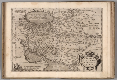
Author
Ortelius, Abraham, 1527-1598
Full Title
Persici Sive Sophorum Regni Typus. Cum privilegio.
List No
10000.107
Author
Ortelius, Abraham, 1527-1598
Full Title
Turcici Imperii Descriptio. Concordia parvae res crescunt, Discordia maxime dilabuntur: Cum privilegio.
List No
10000.109
Author
Ortelius, Abraham, 1527-1598
Full Title
Palestinae Sive Totius Terrae Promissionis Nova Descriptio Auctore Tilemanno Stella Sigenens.
List No
10000.111
Note
Map shows the wandering of the Jews from Egypt through the Sinai Desert and finally to the River Jordan. Each number on the route is one year.
Full Title
Asia Minor. From various authorities. J.H. Seymour sc. Published by Thomas & Andrews. (1812)
List No
0028.021
Note
Engraved map, uncolored. Relief shown by hachures. Shows settlements, rivers, etc.
Author
Arrowsmith, John
Full Title
Turkey in Asia, by J. Arrowsmith. London, pubd. 15 Feby. 1832 by J. Arrowsmith, 35 Essex Street, Strand.
List No
0036.028
Note
Engraved map. Hand colored boundaries. Relief shown by hachures.
Author
[Arrowsmith, John, Burnes, Alexander, Sir.]
Full Title
Central Asia; comprising Bokhara, Cabool, Persia, the River Indus, & countries eastward of it. Constructed from numerous authentic documents, but principally from the original M.S. surveys of Lieut. Alex. Burnes, F.R.S. to whom this map is most respectfully dedicated, by his obliged servant, J. Arrowsmith. June 1834. London, pubd. 16 June by J. Arrowsmith, 35 Essex Street, Strand.
List No
0036.029
Note
Engraved map. Hand colored boundaries. Relief shown by hachures. Shows routes of Alexander Burnes. Eastern portion is a past-on on printed on thin paper.
Author
Brue, Adrien Hubert, 1786-1832
Full Title
Carte generale de l'Egypte ancienne, de la Palestine et de l'Arabie Petree par A.H. Brue, Geographe de S.A.R. Monsieur. A Paris, Chez l'Auteur, rue des Macons Sorbonne, no. 9, et chez les principaux marchands de geographie. Avril 1822.
List No
0096.004
Note
Hand colored engraved map. Relief shown by hachures. Includes table.
Author
Brue, Adrien Hubert, 1786-1832
Full Title
Carte de la Palestine sous la domination romaine, dressee par A. Brue, Geographe du Roi, d'apres les observations astronomiques et les voyages le plus recente. (with) Les douze tribus. Paris, 1828. Chez l'Auteur, rue des Macons-Sorbonne, no. 9, et chez les principaux marchands de cartes geographiques. L'Eau-forte des montagnes par E.P. Michel.
List No
0096.005
Note
Hand colored engraved map. Relief shown by hachures. Includes descriptive note.
Author
Brue, Adrien Hubert, 1786-1832
Full Title
Carte generale de l'Asie-Mineure, de l'Armenie, de la Syrie, de la Mesopotamie, du Caucase &a. par A.H. Brue, Geographe de S.A.R. Monsieur. A Paris, Chez l'Auteur, rue des Macons-Sorbonne, no. 9, et chez les principaux marchands de geographie. Mars 1822.
List No
0096.007
Note
Hand colored engraved map. Relief shown by hachures.
Author
Brue, Adrien Hubert, 1786-1832
Full Title
Carte generale de la Turquie d'Asie, de la Perse, de l'Arabie, du Caboul et du Turkestan Independant. Par A. Brue, Geographe du Roi. A Paris, Chez l'Auteur, rue des Macons-Sorbonne, no. 9, et chez les principaux marchands de geographie. Xbre 1822. Revue en 1826.
List No
0096.044
Note
Hand colored engraved map. Relief shown by hachures. Prime meridian: Paris.
Author
Finley, Anthony
Full Title
Palestine. Young & Delleker Sc. Published by A. Finley, Philada. (to accompany) A New General Atlas Comprising a Complete Set of Maps, representing the Grand Divisions Of The Globe ... Philadelphia: Published by Anthony Finley. 1827.
List No
0282.060
Note
Full color map of Palestine, Israel or the Holy Land. Covers the region from Sidon and Damascus in the north to the southern tip of the Dead Sea or Zoar. Divided with color coding according to the Biblical tribes of Israel. Includes explanation. Relief shown pictorially. Prime meridians are Washington and Greenwich. Shows cities, river systems, deserts and mountains.
Author
Johnston, Alexander Keith, 1804-1871
Full Title
Turkey in Asia, Asia Minor, and Transcaucasia. By Keith Johnston, F.R.S.E. Engraved & printed by W. & A.K. Johnston, Edinburgh. William Blackwood & Sons, Edinburgh & London, (1861)
List No
0373.033
Note
Engraved map. Boundaries hand col.; hydrography printed in blue. Relief shown by hachures. "Keith Johnston's general atlas 29."
Author
Johnston, Alexander Keith, 1804-1871
Full Title
Palestine or the Holy Land by Keith Johnston, F.R.S.E. Engraved & printed by W. & A.K. Johnston, Edinburgh. William Blackwood & Sons, Edinburgh & London, (1861)
List No
0373.034
Note
Engraved map. Boundaries hand col.; hydrography printed in blue. Relief shown by hachures. Shows battle sites, etc. Includes list of Arabic terms with their English equivalents. "Keith Johnston's general atlas 30."
Author
Larousse
Full Title
Asie Occidentale.
List No
0418.219
Author
Lizars, Daniel
Full Title
Turkey in Asia. Published by D. Lizars, Edinburgh. (1831?)
List No
0436.044
Note
Hand colored engraved map. Relief shown pictorially.
Author
Lizars, Daniel
Full Title
Arabia with the adjacent countries of Egypt & Nubia. Published by D. Lizars, Edinburgh. (1831?)
List No
0436.045
Note
Hand colored engraved map. Relief shown by hachures. Shows settlements, caravan routes, oases, etc.
Author
Lizars, Daniel
Full Title
Persia. Published by D. Lizars, Edinburgh. (1831?)
List No
0436.046
Note
Hand colored engraved map. Relief shown by hachures.
Author
Lizars, William Home, 1788-1859
Full Title
Arabia with the adjacent countries of Egypt & Nubia. Published by W. Lizars, Edinburgh. (to accompany) Lizars' Edinburgh Geographical General Atlas ... 1841.
List No
0438.056
Note
Double page engraved hand colored in outline. Relief shown by hachures. Shows political boundaries, towns, roads, rivers and mountains.
Author
Lizars, William Home, 1788-1859
Full Title
Persia. Published by W. Lizars, Edinburgh. (to accompany) Lizars' Edinburgh Geographical General Atlas ... 1841.
List No
0438.057
Note
Double page engraved hand colored in outline. Relief shown by hachures. Shows administrative boundaries, towns, roads, rivers and mountains.
Author
Malte-Brun, Conrad, 1775-1826
Full Title
Geographie des Hebreux, 1831. No. 1. Longitude du Meridien Lutece. Grave par Thierry.
List No
0458.001
Note
Engraved map with country boundaries trimmed in color. Major relief shown by hachures. Rivers, lakes, islands, peoples, and regions shown. Includes 3 scales.
Author
Malte-Brun, Conrad, 1775-1826
Full Title
Geographie d'Herodote, 1831. No. 3. Longitude du Meridien de Lutece. Grave par Thierry.
List No
0458.003
Note
Engraved map with continent boundaries trimmed in color. Major relief shown by hachures. Rivers, lakes, islands, peoples, and regions shown. Text in Latin.
Author
Malte-Brun, Conrad, 1775-1826
Full Title
Systemes Geographiques de Ptolemee, de Strabon & d'Eratosthene, 1831. No. 4. Grave par Thierry.
List No
0458.004
Note
Engraved map with continent boundaries trimmed in color. Major relief shown by hachures. Rivers, lakes, islands, peoples, and regions shown. In three sections: System of Ptolemy at 1:70,000,000; System of Eratosthene at 1:140,000,000; System of Strabon at 1: 140,000,000. Text in Latin.
Author
Malte-Brun, Conrad, 1775-1826
Full Title
Empire d'Alexandre. No. 5. Longitude du Meridien de Lutece. Grave par Thierry. (1837)
List No
0458.005
Note
Engraved map with continent boundaries trimmed in color. Major relief shown by hachures. Rivers, lakes, islands, peoples, and regions shown. Text in Latin.
Author
Malte-Brun, Conrad, 1775-1826
Full Title
Monde Connu des Anciens, au IIe Siecle de l'Ere Chretienne. No. 6. Longitude du Meridien de I'lle de Fer. Grave par Thierry. (1837)
List No
0458.006
Note
Engraved map with continent boundaries trimmed in color. Major relief shown by hachures. Rivers, lakes, islands, and regions shown. Shows 14 scales. Text in Latin.
Author
Malte-Brun, Conrad, 1775-1826
Full Title
Asie Ancienne, 1831. No. 8. Longitude du Meridien de Lutece. Grave par Thierry.
List No
0458.008
Note
Engraved map with continent boundaries trimmed in color. Major relief shown by hachures. Rivers, lakes, islands, and regions shown. Text in Latin.
Author
[Desbuissons, L.E., Migeon, J.]
Full Title
Turquie D'Asie et Persie. Grave par L. Smith. Dresse Sous La Direction De J. Migeon Par Ch. Lacoste. Migeon, editeur, imp, r. du Moulin Vert, Paris. Ecrit par A. Bizet. (1892). Fillatreau del. and Soudain sc. (for vignette).
List No
0507.045
Note
Full color by country. Relief shown by hachures. Vignette of Damas.
Author
Mitchell, Samuel Augustus
Full Title
Persia, Arabia, &c.
List No
0545.070
Note
Full color map by provinces. Includes explanation chart, showing capitals, important towns, etc. Relief shown by hachures. Prime meridian is Greenwich.
Author
Mitchell, Samuel Augustus Jr.
Full Title
Map of Persia, Turkey in Asia. Afghanistan, Beloochistan. Entered ... 1867 by S. Augustus Mitchell, Jr. ... Pennsylvania. (inset map) Palestine or the Holy Land.
List No
0579.058
Note
Full color map by region. Relief shown by hachures. Prime meridians are Greenwich and Washington, D.C.
Author
Mitchell, Samuel Augustus
Full Title
Map of Persia, Arabia, Turkey in Asia, Afghanistan, Beloochistan. Entered ... 1879 by S. Augustus Mitchell ... Washington. (1880)
List No
0586.066
Note
Hand colored. Relief shown by hachures. Shows settlements, rivers, etc.
Author
[Gamble, William H., Mitchell, Samuel Augustus]
Full Title
A new map of Palestine or the Holy Land. (with) Modern Jerusalem. Drawn and engraved by W.H. Gamble, Philada. Entered ... 1879 by S. Augustus Mitchell ... Washington. (1880)
List No
0586.067
Note
Hand colored map with inset. Relief shown by hachures. Shows political divisions, roads, settlements, rivers, etc.
Author
Mitchell, Samuel Augustus Jr.
Full Title
Map of Persia, Arabia, Turkey in Asia, Afghanistan, Beloochistan. Copyright by S. Augustus Mitchell 1884.
List No
0592.067
Note
Hand colored. Relief shown by hachures. Shows settlements, rivers, etc.
Full Title
Map of Persia, Arabia, Turkey in Asia, Afghanistan, Beloochistan. Copyright 1887 by Wm. M. Bradley & Bro. (1890)
List No
0594.065
Note
Hand colored. Relief shown by hachures. Shows settlements, rivers, etc.
Author
Pinkerton, John, 1758-1826
Full Title
Turkey in Asia. Drawn under the direction of Mr. Pinkerton by L. Hebert. Neele sculpt. 352 Strand. London: published Sepr. 1st. 1813, by Cadell & Davies, Strand & Longman, Hurst, Rees, Orme, & Brown, Paternoster Row.
List No
0732.033
Note
Engraved map. Full hand col. Relief shown by hachures. "Pinkerton's modern atlas."
|