|
REFINE
Browse All : World Atlas of Israel from 1967
1-5 of 5
Author
Polish Army Topography Service
Full Title
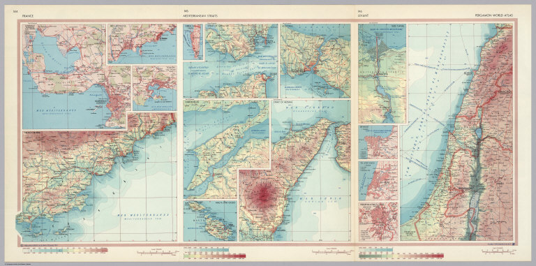
France. Mediterranean Straits. Levant. Pergamon World Atlas. Pergamon Press, Ltd. & P.W.N. Poland 1967. Sluzba Topograficzna W.P.
List No
0737.097
Note
Double-fold map shows three areas in detail: (1) France has 1:500,000 locales of Cote d'Azur, Marseille (Marseilles), Nice, (and) Monaco, French Riviera, and Toulon; (2) Mediterranean Straits has 1:500,000 Gibraltar, Strait of Gibraltar, Dardanelles, Malta and Gozo, Strait of Messina, and Bosporus (Istanbul); and (3) Levant has varying scales including Tel-Aviv-Fayo, Beyrout (Beirut), Suez Canal, and Yerushalayim, El Quds (Jerusalem).
Author
Polish Army Topography Service
Full Title
Turkey, Israel, Cyprus, Lebanon, Syria, Iraq, Jordan. Pergamon World Atlas. Pergamon Press, Ltd. & P.W.N. Poland 1967. Sluzba Topograficzna W.P.
List No
0737.165
Note
Twenty-five small maps and graphics showing: agriculture, relief types, crops, population, livestock, climate, industry, power, industrial goods, land use, industry, mining, and foreign trade.
Author
USSR (Union of Soviet Socialist Republics).
Full Title
(Map Title Page) 149-150. East Mediterranean Lands and Iraq. 151. Palestine and Lebanon.
List No
1603.160
Author
USSR (Union of Soviet Socialist Republics).
Full Title
149-150. East Mediterranean Lands and Iraq. Baghdad. The World Atlas.
List No
1603.161
Note
City vicinity map at scale 1:250,000.
Author
USSR (Union of Soviet Socialist Republics).
Full Title
151. Palestine and Lebanon. Beirut. The World Atlas.
List No
1603.162
1-5 of 5
|