|
REFINE
Browse All : World Atlas of Falkland Islands
1-19 of 19
Author
[Arrowsmith, John, 1790-1873, Fitzroy, Robert, 1805-1865]
Full Title
The Falkland Islands, surveyed by Captns. Robert Fitz Roy R.N. William Robinson, R.N. and Barth W. James Sullivan, R.N. 1848. John Arrowsmith 10 Soho Square 1849. London, Pub 15 Augt. 1849, by John Arrowsmith, 10 Soho Square.
List No
14506.131
Note
Map representing the Falkland Islands. Shows cities, roads, bodies of water, drainage, coastlines, islands, and depths. Includes a legend,as well as latitudinal and longitudinal lines. With ancillary map: [The World]. Map is 50 x 62 cm, on double sheet 56 x 67 cm.
Author
Colton, G.W.
Full Title
Patagonia (with) South Orkney Or Powell's Group. (with) Falkland Islands (with) South Georgia Island. Published By J.H. Colton & Co. No. 172 William St. New York. Entered ... 1855 by J.H. Colton & Co. ... New York. No. 63.
List No
0149.068
Note
Patagonia and each group of islands is shown on a separate uncolored map (four total) surrounded by a decorative border.
Author
Kitchin, Thomas
Full Title
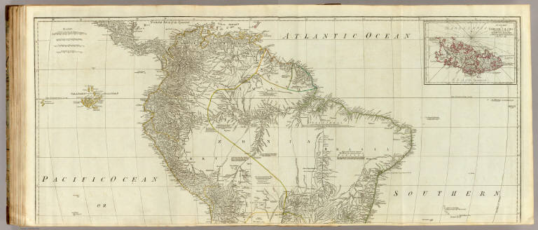
(A map of South America, containing Tierra-Firma, Guyana, New Granada, Amazonia, Brasil, Peru, Paraguay, Chaco, Tucuman, Chili and Patagonia. Northern section. From Mr. d'Anville with several improvements and additions, and the newest discoveries. London, printed for Robert Sayer, no. 53 Fleet Street, as the Act directs, July the 1st 1787)
List No
0411.045
Note
Engraved map in outline color. Printed on 2 sheets. Relief shown pictorially; depths by soundings. Includes descriptive notes. Inset map at [ca. 1:2,000,000]: A chart of the Falkland's Islands, named by the French Malouine Islands, and discovered by Hawkins in the year 1595. Prime meridian: Ferro. David Rumsey Collection copy mounted as 1 sheet.
Author
Kitchin, Thomas
Full Title
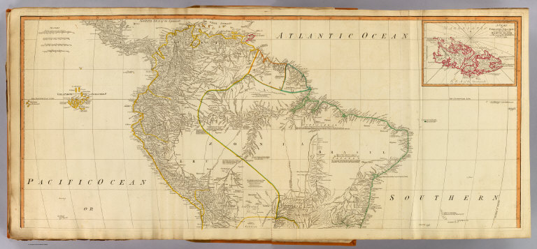
(Composite of) A map of South America, containing Tierra-Firma, Guyana, New Granada, Amazonia, Brasil, Peru, Paraguay, Chaco, Tucuman, Chili and Patagonia. From Mr. d'Anville with several improvements and additions, and the newest discoveries. London, printed for Robert Sayer, no. 53 Fleet Street, as the Act directs, July the 1st 1787.
List No
0411.047
Note
Engraved map in outline color. Printed on 4 sheets. Relief shown pictorially; depths by soundings. Inset map at [ca. 1:2,000,000]: A chart of the Falkland's Islands, named by the French Malouine Islands, and discovered by Hawkins in the year 1595. Includes descriptive notes and text "Division of South America with a summary account of its trade," and large ornamental cartouche. Prime meridian: Ferro. David Rumsey Collection copy mounted as 2 sheets. (W 103--W 20/N 13--S 56)
Author
[Martin, R.M., Tallis, J. & F.]
Full Title
Falkland Islands And Patagonia. The Illustrations by H. Winkles & Engraved by W. Lacey. The Map Drawn & Engraved by J. Rapkin.
List No
0466.078
Note
Two separate maps on one page, both in outline color. The top map of the Falklands show the Jason islands, penguins and sea eagles. The bottom map includes an illustration depicting the Fugeans and another showing Christmas Sound. Leafy border surrounds both maps.
Author
Society for the Diffusion of Useful Knowledge (Great Britain)
Full Title
South America sheet V. Patagonia. (with) Isle of Georgia. (with) The South Shetlands and Orkneys. Published under the superintendence of the Society for the Diffusion of Useful Knowledge. Engraved by J. & C. Walker. London, published by Chapman & Hall, 186 Strand, April 2nd, 1838. (1844) Printed by J. & C. Walker.
List No
0890.152
Note
Engraved map. Relief shown by hachures and spot heights. Boundaries hand col. Covers also the Falkland Islands. David Rumsey Collection copy incorrectly bound in atlas as no. 154 (should be 153)
Author
[Stieler, Adolf, Habenicht, H., Petermann, A, Petermann, A.]
Full Title
Nr. 99. Sued-Amerika, Bl. 5. ... H. Habenicht. (insets) Panama. Valparaiso. Santiago. Lima.
List No
0962.215
Author
[Stieler, Adolf, Haack, H.]
Full Title
108. Suedchile - Patagonien. (insets) Santiago. Valparaiso.
List No
12248.226
Author
[Schraembl, Franz Anton, D'Anville]
Full Title
26. Karte von Sued-America (northern sheet), Ferfasst von Herrn d'Anville, Geographen des Koenig von Frankreich, Nach den neuesten Entdeckungen verbessert herausgegeben von Herrn F.A. Schraembl. MDCCLXXXVI. (inset) Malouinische oder Falklands Inseln.
List No
12498.045
Author
Stanford, Edward, 1827-1904
Full Title
80. The Falkland Islands, surveyed by Captns. Robert Fitz Roy, R. N., William Robinson, R. N., and Barth W. James Sulivan, R. N. : On Mercator's projection. London: Edward Stanford, 55 Charing Cross, S.W.
List No
14053.042
Note
Map of the Falkland Islands, in colored lithograph and on double plate. Shows bays, bluffs, rocks, shoals, cays, and soundings in fathoms. Features arrows illustrating floods and ebbs. Relief illustrated with hachures. Includes a legend indicating, for instance: broken, fine, mud, shells, stones. With explanation, stating: Roman figures (VII) show the times of high water ... Kelp which ships should avoid. Descriptive text throughout, e.g.: Fine valley well watered. With inset: (World map). 51 x 65 cm, on sheet 56 x 68 cm. In Vol. I.
Author
[Colton, G.W., Fisher, Richard Swainson]
Full Title
(Text Page) Falkland Islands.
List No
1690.166
Note
Includes inset map of Falkland Islands.
Author
Vandermaelen, Philippe, 1795-1869
Full Title
Iles Malouines ou Falkland. Amer. Merid. no. 41. (Dresse par Ph. Vandermaelen, lithographie par H. Ode. Cinquieme partie. - Amer. merid. Bruxelles. 1827)
List No
2212.325
Note
Hand col. lithographed map. Covers also parts of coast of Santa Cruz Province from Punta Medanosa to Cabo San Francisco de Paula. Includes text: Note sur les Iles Malouines -- Note sur Buenos-Ayres. Pour le commencement voyez la carte no. 37.
Full Title
(A map of South America containing Tierra-Firma, Guayana, New Granada, Amazonia, Brasil, Peru, Paraguay, Chaco, Tucuman, Chili and Patagonia, from Mr. d'Anville with several improvements and additions, and the newest discoveries. North half. (with) A chart of Falkland's Islands named by the French Malouine Islands and discovered by Hawkins, in the year 1593. London, Published by Laurie & Whittle, No. 53 Fleet Street, as the act directs 12th May, 1794)
List No
2310.089
Note
Hand colored engraved map with inset. Relief shown pictorially; depths by soundings. Shows settlements, roads, Indian tribes, etc. Includes descriptive notes. Prime meridian: Ferro. Printed on 2 sheets; joined.
Author
[Anville, Jean Baptiste Bourguignon d, 1697-1782, Robert Laurie & James Whittle]
Full Title
(Composite of) A map of South America containing Tierra-Firma, Guayana, New Granada, Amazonia, Brasil, Peru, Paraguay, Chaco, Tucuman, Chili and Patagonia, from Mr. d'Anville with several improvements and additions, and the newest discoveries. (with) A chart of Falkland's Islands named by the French Malouine Islands and discovered by Hawkins, in the year 1593. London, Published by Laurie & Whittle, No. 53 Fleet Street, as the act directs 12th May, 1794.
List No
2310.091
Note
Digital composite of 2 hand colored engraved maps with inset. Relief shown pictorially; depths by soundings. Shows settlements, roads, Indian tribes, etc. Includes text "Divisions of South America with a summary account of its trade," descriptive notes and illustrated cartouche. Prime meridian: Ferro. Printed on 4 sheets; joined as 2.
Author
Colton, G.W.
Full Title
Colton's Patagonia. South Orkney or Powell's Group. Falkland Islands. South Georgia Island. Published By G. W & C. B. Colton & Co. No. 172 William St. New York.
List No
4587.077
Note
Prime meridians are Washington D.C. and Greenwich.
Author
Radefeld, Carl Christian Franz, 1788-1874
Full Title
Sudlichster Theil von America enthaltend Patagonia, Feuerland & Falklands Gruppe, 1844. Entworf. u. gez. v. Hauptm. Radefeld. (with) Das Antarctische Continent. Verlag des Bibliograph. Instituts zu Hildburghsn., Amsterdam, Paris u. Philadelphia, (1860)
List No
4807.174
Note
Engraved map. Boundaries hand col. Relief shown by hachures and spot heights. Scale of inset map (ca. 1:120,000,000). "Meyers Hand Atlas No. 13." Prime meridian: Ferro.
Author
Garnier, F. A., 1803-1863
Full Title
Patagonie, et Detroit de Magellan, Terres Australes. Atlas spheroidal & universel de geographie dresse par F.A. Garnier, geographe. Vve. Jules Renouard, Editeur, Rue de Tournon, no. 6, Paris. 1860. Sarazin, imp., r. Git-le-Coeur, 8, Paris.
List No
5023.059
Note
Full col. Relief shown by hachures. Shows tribes, etc. Covers also Falkland Islands and a part of Uruguay. Inset: Carte des Terres Australes. Prime meridian: Paris. On globe in cartouche: Sphericite de la terre.
Author
[Edward Stanford Ltd., Fitzroy, Robert, Robinson, William, Stanford, Edward, Sullivan, Bartholomew James]
Full Title
The Falkland Islands, surveyed by Captns. Robert Fitz Roy, R.N., William Robinson, R.N. and Barthw. James Sullivan, R.N. London atlas series. Stanford's Geographical Establishment. London : Edward Stanford, 26 & 27, Cockspur St., Charing Cross, S.W. (1901)
List No
5075.095
Note
Full color. Relief shown by hachures and spot heights; depths by soundings. Shows settlements, times of high tides, kelp beds, etc.
Author
W. & A.K. Johnston Limited
Full Title
South Argentina.
List No
6921.141
1-19 of 19
|