|
Author
Monte (Monti), Urbano, 1544-1613
Full Title
Tavola XXIIII. Che Ha Sua Superiore La Tavola. XII. Libro Terzo.
List No
10130.026
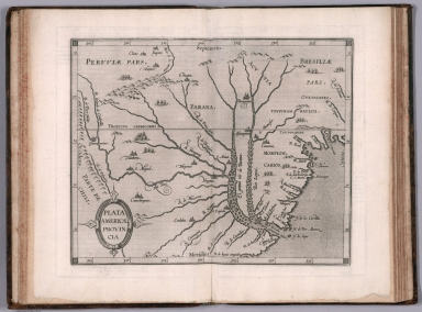
Author
[Wytfliet, Corneille, Magini, Giovanni Antonio]
Full Title
Plata Americae provincia. (to accompany) Histoire universelle des Indes occidentales et orientales, et de la conversion des Indiens : divisee en trois parties par Cornille Wytfliet & Anthoine Magin & autres historiens. Premiere Partie. A Douay, Chez Francois Fabri, l'An 1611.
List No
11622.020
Note
Uncolored engraved double page map of the Rio de la Plata region. Covers Argentina, Uruguay and the southern part of Brazil. Shows cities, towns, landmarks, rivers, capes, bays and mountains. Relief shown pictorially. Includes decorative title cartouche.
Author
Arrowsmith, John
Full Title
Brazil, by J. Arrowsmith. London, pubd. Feby. 15, 1832 by J. Arrowsmith, 35 Essex Street, Strand.
List No
0036.049
Note
Engraved map. Hand colored boundaries. Relief shown by hachures. Shows political divisions, roads, Indian tribes, etc. Includes the Guianas, Paraguay and Uruguay.
Author
Brue, Adrien Hubert, 1786-1832
Full Title
Carte du Bresil et d'une partie des pays adjacents. Redigee par A. Brue, Geographe du Roi. Paris, 1826. Chez l'Auteur, rue des Macons-Sorbonne, no. 9, et chez les principaux m(archan)ds de cartes geographiques.
List No
0096.066
Note
Hand colored engraved map. Relief shown by hachures. Prime meridian: Paris. Extension of map at left pasted on. Covers also Paraguay and Uruguay.
Author
Colton, G.W.
Full Title
Brazil And Guayana (with) two inset maps: Pernambuco and Rio de Janeiro. Published By J.H. Colton & Co. No. 172 William St. New York. Entered ... 1855 by J.H. Colton & Co. ... New York. No. 61.
List No
0149.066
Note
In full color by region.
Author
Colton, G.W.
Full Title
Colton's Brazil and Guayana. (inset) Rio de Janeiro and Pernambuco. Published By J. H. Colton. No. 172 William St. New York.
List No
0151.070
Note
Prime meridians are Greenwich and Washington D.C. Relief shown by hachures.
Author
Colton, G.W.
Full Title
Colton's Brazil and Guayana. (inset) Pernambuco and Rio de Janeiro. Published By G. W & C. B. Colton & Co. No. 172 William St. New York.
List No
0152.072
Note
Prime meridians are Washington D.C. and Greenwich.
Author
[Dower, John, Higgins, W.M.]
Full Title
Brazil.
List No
0247.130
Author
[Bowen, Emanuel, Gibson, John]
Full Title
Brasil. (to accompany) Atlas Minimus or a New Set of Pocket Maps of the Several Empires, Kingdoms and States of the Known World, with Historical Extracts relative to each. Drawn and Engraved by J. Gibson from the Best Authorities, Revis'd, Corrected and Improv'd by Eman: Bowen Geographer to His Majesty.
List No
0300.054
Note
First edition. The "Historical Extracts" are short bits of text printed on the maps giving relevant geographical information. A revised edition was published in London in 1792. In 1759, another edition was published adding separate geographical descriptions and correcting some of the maps (see our copy). The Philadelphia 1798 edition by Mathew Carey incorporates the 1759 edition text word for word (excepting the maps of United States which Carey omits in favor of his pocket atlas of the U.S.). Gibson and Bowen made the four sheet map of North America (Stevens 49), and Gibson made the four sheet map of America (Stevens 3).
Author
Johnston, Alexander Keith
Full Title
South America (northern sheet). (with) Galapagos Isles. By Keith Johnston, F.R.S.E. Keith Johnston's General Atlas. Engraved, Printed, and Published by W. & A.K. Johnston, Edinburgh & London.
List No
0377.054
Note
Countries and provinces outlined in color. Relief shown by hachures. Five scales. One inset.
Author
Johnston, Alexander Keith
Full Title
South America (southern sheet). By Keith Johnston, F.R.S.E. Keith Johnston's General Atlas. Engraved, Printed, and Published by W. & A.K. Johnston, Edinburgh & London.
List No
0377.055
Note
Countries and provinces outlined in color. Relief shown by hachures. Five scales.
Author
Lizars, Daniel
Full Title
Lower Peru, Brazil & Paraguay. Published by D. Lizars, Edinburgh. (1831?)
List No
0436.064
Note
Hand colored engraved map. Relief shown by hachures. Shows settlements, rivers, etc.
Author
Lizars, William Home, 1788-1859
Full Title
Lower Peru, Brazil & Paraguay. Published by W. Lizars, Edinburgh. (to accompany) Lizars' Edinburgh Geographical General Atlas ... 1841.
List No
0438.079
Note
Double page engraved hand colored in outline. Shows political boundaries, cities, Indian settlements, rivers and mountains. Relief shown by hachures. Prime meridian is Greenwich.
Author
Malte-Brun, Conrad, 1775-1826
Full Title
Carte de Bresil, 1836. No. 65. Grave par Thierry.
List No
0458.067
Note
Engraved map. Countries and states trimmed in color. Rivers, lakes, islands, and peoples shown. Major relief shown by hachures. Includes 4 scales.
Author
[Martin, R.M., Tallis, J. & F.]
Full Title
Brazil. The Illustrations by H. Winkles & Engraved by W. Lacey. The Map Drawn & Engraved by J. Rapkin.
List No
0466.079
Note
Region in outline color surrounded by drawings of boats on the Rio Negro, Cape St. Antonio and three city views: St. Catharina, Monte Video and Rio de Janeiro.
Author
Mitchell, Samuel Augustus
Full Title
Brazil. (with) two inset maps: Paraguay and Environs of Rio Janeiro.
List No
0537.041
Note
In full color.
Author
Mitchell, Samuel Augustus
Full Title
Brazil. (2 inset maps) Paraguay and Environs of Rio Janeiro.
List No
0545.045
Note
Full and outline color map. Includes explanation chart, showing capitals, important towns, etc. Prime meridian is Washington, D.C. Relief shown by hachures.
Author
Mitchell, Samuel Augustus
Full Title
Map Of Brazil, Bolivia, Paraguay, And Uruguay. 50. (with) two inset maps: Harbor Of Rio Janeiro. 51. Harbor of Bahia. 52. (and) Map of Chili. 53. (with) inset map Island Of Juan Fernandez. 54. Entered ... 1860, by S. Augustus Mitchell, Jr. ... Pennsylvania.
List No
0565.031
Note
In full color by region.
Author
Mitchell, Samuel Augustus Jr.
Full Title
Map of Brazil, Bolivia, Paraguay, and Uruguay. (with four insets) 59. Harbor of Rio Janeiro. 60. Harbor of Bahia. 61. Map of Chile. 62. Island of Juan Fernadez. Entered ... 1860 by S. Augustus Mitchell, Jr. ... Pennsylvania.
List No
0572.044
Note
Full color map by country. Relief shown by hachures. Prime meridians are Greenwich and Washington, D.C.
Author
Mitchell, Samuel Augustus Jr.
Full Title
Map of Brazil, Bolivia, Paraguay, and Uruguay. (inset maps) 65. Harbor of Rio Janeiro. 66. Harbor of Bahia. 67. Map of Chili. 68. Island of Juan Fernandez. Entered ... 1867 by S. Augustus Mitchell, Jr. ... Pennsylvania.
List No
0579.049
Note
Color map. Relief shown by hachures. Prime meridians are Greenwich and Washington, D.C.
Author
Mitchell, Samuel Augustus
Full Title
Map of Brazil, Bolivia, Paraguay, and Uruguay. (with) Map of Chili. (with) Harbor of Bahia. (with) Harbor of Rio Janeiro. (with) Island of Juan Fernandez. Entered ... 1879 by S. Augustus Mitchell ... Washington. (1880)
List No
0586.056
Note
Hand colored map with 4 insets. Relief shown by hachures. Shows states and departments, settlements, railroads, etc. Prime meridians: Greenwich and Washington.
Author
Mitchell, Samuel Augustus Jr.
Full Title
Map of Brazil, Bolivia, Paraguay, and Uruguay. (with) Map of Chili. (with) Harbor of Bahia. (with) Harbor of Rio Janeiro. (with) Island of Juan Fernandez. Copyright 1886 by Wm. M. Bradley & Bro.
List No
0592.057
Note
Hand colored map with 4 insets. Relief shown by hachures. Shows states and departments, settlements, railroads, etc. Prime meridians: Greenwich and Washington.
Full Title
Map of Brazil, Bolivia, Paraguay, and Uruguay. (with) Map of Chili. (with) Harbor of Bahia. (with) Harbor of Rio Janeiro. (with) Island of Juan Fernandez. Copyright 1887 by Wm. M. Bradley & Bro. (1890)
List No
0594.055
Note
Hand colored map with 4 insets. Relief shown by hachures. Shows states and departments, settlements, railroads, etc. Prime meridians: Greenwich and Washington.
Author
[Morse, Charles W., Colby, Charles A.]
Full Title
Brazil, Peru, Bolivia, Chile, La Plata, Paraguay, and Uruguay. (inset) Western Part of Peru.
List No
0623.046
Author
Polish Army Topography Service
Full Title
Brazil - East - Central. (inset) Brasilia. (inset) Rio De Janeiro. Pergamon World Atlas. Pergamon Press, Ltd. & P.W.N. Poland 1967. Sluzba Topograficzna W.P.
List No
0737.223
Note
Detailed physical and political map.
Author
Polish Army Topography Service
Full Title
Rio De La Plata. Brazil - Sao Paulo - Rio De Janeiro. Pergamon World Atlas. Pergamon Press, Ltd. & P.W.N. Poland 1967. Sluzba Topograficzna W.P.
List No
0737.224
Note
Two detailed political and physical maps showing the vicinities of Rio de Janeiro and Sao Paulo.
Author
Society for the Diffusion of Useful Knowledge (Great Britain)
Full Title
South America sheet III. South Brazil with Paraguay and Uruguay. Published under the superintendence of the Society for the Diffusion of Useful Knowledge. Engraved by J. & C. Walker. London, published by Baldwin & Cradock, 47 Paternoster Row, June 1st, 1837. (London: Chapman & Hall, 1844)
List No
0890.150
Note
Engraved map. Relief shown by hachures. Boundaries hand col. Sources: Spis & Martius, Cazal, Roussin, Barral, Parchappe &c. David Rumsey Collection copy incorrectly bound in atlas as no. 152 (should be 151)
Author
Stanford, Edward
Full Title
Part of Brazil.
List No
0949.112
Note
Countries in full color. Relief shown by hachures and spot heights. Shows settlements, Indian tribes, railroads, submarine telegraph cables, etc.
Author
[Stieler, Adolf, Habenicht, H., Salzmann, H., Petermann, A.]
Full Title
Nr. 98. Sued-Amerika, Bl. 4. ... von H. Habenicht und H. Salzmann.
List No
0962.213
Author
Tanner, Henry S.
Full Title
Brazil. (insets) Paraguay. Environs of Rio Janeiro.
List No
0976.039
Note
Date estimated. Prime meridian Washington.
Author
Tanner, Henry S.
Full Title
Brazil. (with) two inset maps: Paraguay and Environs of Rio Janeiro. Published by H.S. Tanner, Philadelphia. (above neat line) Tanner's Universal Atlas.
List No
0977.034
Note
In full color by region.
Author
Tanner, Henry S.
Full Title
Brazil. (insets) Paraguay. Environs of Rio Janeiro.
List No
0980.042
Note
Date estimated. Prime meridian Washington.
Author
Blaeu, Joan, 1596-1673
Full Title
Brasilia
List No
10017.656
Note
60 Duytsche mylen 15 op een graedt = 4.2 cm [et al.]
Author
Blaeu, Joan, 1596-1673
Full Title
Sinvs Omnivm Sanctorvm
List No
10017.657
Note
Mensura duroum miliarium Germanicorum Mate van twee Duÿtsche Mÿlen = 7.6 cm
Author
Blaeu, Joan, 1596-1673
Full Title
Praefectra De Cirîiî
List No
10017.658
Note
5 Milliaria horaria quorum novemdecim uni gradui latitud. respondent = 6.8 cm
Author
Blaeu, Joan, 1596-1673
Full Title
Praefecturae Paranambucae Pars Borealis
List No
10017.659
Note
4 Milliaria Germanica 15. uni gradui respondentia = 6.8 cm [et al.]
Author
Blaeu, Joan, 1596-1673
Full Title
Praefecturae Paranambucae Pars Meridionalis
List No
10017.660
Note
5 Milliaria horaria quorum novemdecim uni gradui latitud. respondent = 6.8 cm
Author
Blaeu, Joan, 1596-1673
Full Title
Praefectura De Paraiba, Et Rio Grande
List No
10017.661
Note
8 Milliaria horaria quorum novemdecim uni gradui latitud. respondent = 10.8 cm
Author
Fer, Nicolas de, 1646-1720
Full Title
Le Bresil dont les co��tes sont divise��es en capitaineries Dresse�� sur les dernie��res re��lations des filibustiers et fameux voyageurs
List No
10022.106
Author
[Martin, R.M., Tallis, J. & F.]
Full Title
Brazil. The Illustrations by H. Winkles & Engraved by W. Lacey. The Map Drawn & Engraved by J. Rapkin.
List No
10095.080
Note
Region in outline color surrounded by drawings of boats on the Rio Negro, Cape St. Antonio and three city views: St. Catharina, Monte Video and Rio de Janeiro.
Full Title
South America. (with) Rio de Janeiro and Espirito Santo. (with) South-east Brazil and Uruguay. (with) Chile. (Published at the office of "The Times," London, 1895)
List No
1010.066
Note
Color maps with inset. Relief shown by hachures and spot heights. Shows settlements, railroads, etc. Scale of insets: 1:9,500,000-1:10,000,000.
Author
[Touring club italiano, Funk & Wagnalls Company.]
Full Title
(Legend to) Brasile, Bolivia, Paraguay, Guaiana. Propr. Artistico-letteraria del T.C.I. Ufficio cartografico del T.C.I. (1929)
List No
1012CZ
Note
Explanation to map.
Author
[Touring club italiano, Funk & Wagnalls Company.]
Full Title
Brasile, Bolivia, Paraguay, Guaiana. Propr. Artistico-letteraria del T.C.I. Ufficio cartografico del T.C.I. (1929)
List No
1012.084
Note
Color map. Relief shown by hachures and spot heights; depths by isolines. Includes inset of the Rio de Janeiro region at 1:250,000 scale.
Author
[Touring club italiano, Funk & Wagnalls Company.]
Full Title
(Legend to) Brasile Meridionale e Uruguay, Brasil meridional e Uruguay. Propr. Artistico-letteraria del T.C.I. Ufficio cartografico del T.C.I. (1929)
List No
1012DA
Note
Explanation to map.
Author
[Touring club italiano, Funk & Wagnalls Company.]
Full Title
Brasile Meridionale e Uruguay, Brasil meridional e Uruguay. Propr. Artistico-letteraria del T.C.I. Ufficio cartografico del T.C.I. (1929)
List No
1012.085
Note
Color map. Relief shown by hachures; depths by isolines. Includes inset of the Montevideo region at 1:250,000 scale. Southern part of map shown on inset.
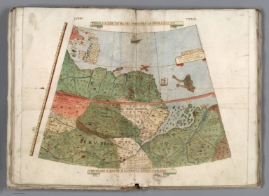
Author
Monte (Monti), Urbano, 1544-1613
Full Title
Tavola XXIII. Che Ha Sua Superiore La Tavola. XI.E.XII. Libro Terzo.
List No
10130.025
Author
[Blaeu, Joan, 1596-1673, publisher., Marggraf, Georg, 1610-1644, Baerle, Caspar van, 1584-1648, Post, Frans Jansz, 1612-1680]
Full Title
Brasilia qua parte paret Belgis.
List No
10151.042
Note
1 map : copperplate engraving on 9 sheets, hand colour. Oriented with north at the right. Title at the top of the map, framed by two fruit swags. Suspended below the title are the arms of the Netherlands (left), Dutch Brazil (centre) and the Prince of Orange (right). Four rows of images in the Brazilian interior (top right), the top row devoted to local flora and fauna, the lower three to landscape views of indigenous settlements and practices. These illustrations were supplied by Frans Post, one of the artists John Maurice encouraged to settle in Dutch Brazil. See J. de Sousa-Leão, 'Frans Post in Brazil', Burlington Magazine, LXXX, 1942, pp. 58-61. Introduction to the map in a large cartouche at the far left, surrounded by martial arms, cornucopias made of thick skin (including one which emits steam), and the arms of John Maurice, Prince of Nassau-Siegen (1604-79), governor of the Dutch possessions in Brazil between 1637 and 1644. Scaled inset map of the Brazilian coastline below the cartouche ('MARITIMA BRASILIÆ UNIVERSÆ'), on a scroll made of the same, thick material. Key on a sheet at the bottom edge of the map. Cartouche in the bottom right corner, titled 'PRÆFECTURÆ DE PARAIBA, ET RIO GRANDE'. Accompanied by three descriptions of Dutch Brazil below the map, in Latin (top), Dutch (middle) and French (bottom). The text is based on Caspar Barlaeus' (see note below). In the 1630s Blaeu replaced Visscher as the favoured cartographer of the Dutch West India Company, just in time to benefit from the Company's forays into the newly conquered territories of Dutch Brazil. In 1642 he produced a map of the colony for his new atlas, and six years later he published this large wall map, which was supplemented with Post's illustrations and Georg Marggraf's researches into the Brazilian interior.
Author
[Mercator, Gerhard, 1512-1594, Hondius, Jodocus, 1563-1612, Hondius, Hendrik, 1597-1651]
Full Title
Accuratissima Brasiliae Tabula. Amstelodami Henricus Hondius excudit
List No
10621.209
Author
[Andriveau-Goujon, J., Brue, Adrien Hubert, 1786-1832]
Full Title
Carte du Bresil et d'une partie des pays adjacents. Redigee par A. Brue, Geographe du Roi ... Paris, 1826. Chez l'Auteur, rue des Macons-Sorbonne, no. 9, et chez les principaux m(archan)ds de cartes geographiques. (to accompany) Atlas de choix ou Recueil de cartes de geographie ancienne et moderne.
List No
11124.044
Note
Outline hand color engraved map. Extension of map at left pasted on. Covers also Paraguay and Uruguay. Shows political boundaries, towns, villages, roads, etc. Relief shown by hachures. Prime meridian is Paris. Includes color coded reference.
Author
[Ptolemy, Claudius, Ruscelli,Girolamo, Rosaccio, Giuseppe]
Full Title
Brasil Nvova tavola. Descrittione dell'America. Libro Quarto. (to accompany) Geographia di Clavdio Tolomeo alessandrino, tradotta di Greco nell'idioma volgare Italiano da Girolamo Ruscelli ... In Venetia, MDXCIX (1599) Appresso gli heredi di M. Sessa.
List No
11299.070
Note
Engraved map of Brazil. Relief shown pictorially.
|