|
Author
Hoffmann, Johann
Full Title
Austria & Stiria.
List No
15665.006
Note
This map is the same as the map used in "Europaelsch-Geographlsche Spiel-charte" but appeared in the book "Catholischer Raphael/ Das 1st: Cathollsches Rels-Bet-Buchlein..." published in 1677.
Author
Hoffmann, Johann
Full Title
Suevia
List No
15665.011
Note
This map is the same as the map used in "Europaelsch-Geographlsche Spiel-charte" but appeared in the book "Catholischer Raphael/ Das 1st: Cathollsches Rels-Bet-Buchlein..." published in 1677.
Author
Philip, George, 1870-1937.
Full Title
The Austro-Hungarian Empire Including Bosnia & Hertzegovina.
List No
15487.044
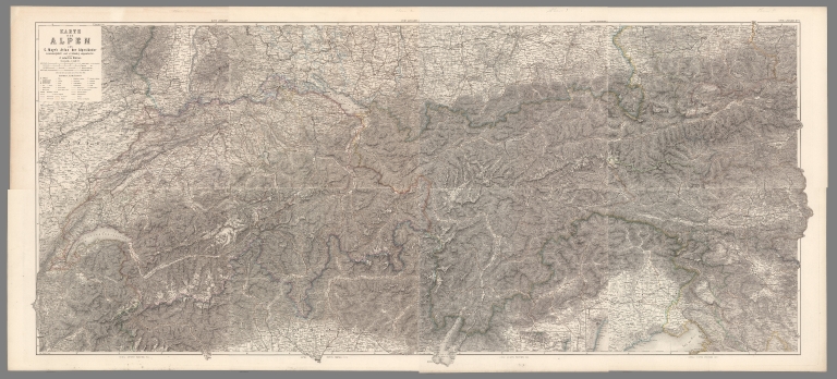
Author
Imhof, Eduard, 1895-1986
Full Title
Alpenländer.
List No
14401.024
Note
Map of the Alpine countries: Austria, France, Germany, Italy, Liechtenstein, Monaco, Slovenia, and Switzerland, in 1969. Shows cities, railways, roads, topography, valleys, glaciers, bodies of water, drainage, coastlines, islands and water depths. Relief shown with contour lines, shading and spot heights. Includes latitudinal and longitudinal lines, a legend, bar scale and scale statement. Colored lithograph. Map is 29 x 39 cm, on double sheet 33 x 44 cm. (Title taken from table of contents.) Appears in section entitled Alpenländer und Österreich [= Alpine countries and Austria].
Author
Imhof, Eduard, 1895-1986
Full Title
Geologie.
List No
14401.030
Note
Map of the Alpine countries - Austria, France, Germany, Italy, Liechtenstein, Monaco, Slovenia, and Switzerland - featuring geology, in 1969. Also shows cities, bodies of water, drainage, coastlines, islands and water depths. Includes latitudinal and longitudinal lines, a legend, bar scale and scale statement. Colored lithograph. Map is 28 x 39 cm, on double sheet 33 x 44 cm. Appears in section entitled Alpenländer und Österreich [= Alpine countries and Austria].
Author
شكوفه مقبل [Şukufe Mukbil]
Full Title
(Austro-Hungary)
List No
10992.010
Note
Dimensions are sheet size.
Author
Stieler, Adolf, 1775–1836
Full Title
(Composite to) Karte der Alpen aus C. Mayr's Atlas der Alpenlander zusammengestellt und vollständig umgearbeitet. 8 colorirte Blätter. Mayr's Alpenkarte II. No. 4. Gotha: Justus Perthes 1875.
List No
13563.055
Note
1 map in 8 plates. Part I:1-4. Part II, No. 1-4. Compiled from Mayr's Atlas der Alpenlander and completely revised.
Author
[Stieler, Adolf, Vogel, C.]
Full Title
(Composite Map) Oesterreich_Ungarn in 4 Blaettern, Blatt 4.
List No
2207.019
Author
Stieler, Adolf
Full Title
(Composite of) Nos. XXI, XXVII, XXIX, XXXI, XXXII. Stieler's Hand-Atlas Deutschland ....
List No
2507.127
Note
Composite of five maps of parts of Germany.
Author
[Brockhaus, F.A., Leeder, Ehrenfried, Leutemann, Heinrich]
Full Title
Oesterreich.
List No
6819.067
Note
Lavishly illustrated around margins of map with high quality vignettes of animals, structures and people. Relief shown in hachures.
Author
[Ortelius, Abraham, 1527-1598, Lazius, Wolfgang, 1514-1565]
Full Title
Austriae Ducatus Chorographia, Wolfgango Lazio Auctore. Cum privilegio.
List No
10000.063
Author
Ortelius, Abraham, 1527-1598
Full Title
Salisburgensis Iurisdictionis, locorumque vicinorum vera descriptio Auctore Marco Secznagel Salisburgensis. Cum privilegio. (inset view) Urbis Salisburgensis Genuina Descriptio. (upper left poem) Qui patriæ adfert ingenio suæ Illustre nomen, Laudibus excolens Dignus favore est, præmioque Quem sequens veneretur ætas Cum Marcus ergo fecerit hoc opus Grato tuum, te quæso, foue sinu Salczburga ciuem, gestiensque Posteritatis honore cinge.
List No
10000.065
Note
Map of the area around Salzburg, Austria, with an inset view of the city.
Author
Appleton, D. & Co.
Full Title
Austria - Hungary. Copyright 1891 by Appleton & Co. (insets) Environs of Budapest; Triest; Prague; Vienna. (to accompany) The Library Atlas Of Modern Geography ... New York, D. Appleton And Company 1892. (on upper margin) Austria 25.
List No
0026.060
Note
Color map on 2 sheets. Shows administrative divisions, major cities, roads, railways, canals, forts and fortifications, principal steam routes and distances from place to place, battle fields, forts and fortification, etc. Includes reference. Relief shown by hachures and spot heights in feet. Prime meridian is Greenwich.
Author
Arrowsmith, Aaron
Full Title
Austrian Dominions. From Arrowsmith's map of Europe. Hooker sculpsit. (Boston: Published by Thomas & Andrews. 1812)
List No
0028.009
Note
Engraved map, hand colored. Relief shown by hachures. Shows administrative divisions, cities, rivers, etc.
Full Title
Germany south of the Mayn. Engraved by Thomas Marshall. (Boston: Published by Thomas & Andrews. 1812)
List No
0028.018
Note
Engraved map, uncolored. Relief shown by hachures. Shows duchies, etc., settlements, rivers, etc.
Author
Arrowsmith, John
Full Title
Austrian Empire, by J. Arrowsmith. London, pubd. 15 Feby. 1832 by J. Arrowsmith, 35 Essex Street, Strand.
List No
0036.015
Note
Engraved map. Hand colored boundaries. Relief shown by hachures.
Author
Brue, Adrien Hubert, 1786-1832
Full Title
Carte generale de l'Empire d'Allemagne, des royaumes de Hongrie, de Gallicie, de Prusse, et des Provinces-Unies de Pays-Bas; en 1789. Redigee pour la lecture de l'histoire du moyen age, par A. Brue, Geographe du Roi. Paris, 1826. A Paris, Chez l'Auteur, rue des Macons-Sorbonne, no. 9, et chez les principaux m(archan)ds de cartes geographiques.
List No
0096.030
Note
Hand colored engraved map. Relief shown by hachures. Prime meridian: Paris.
Author
Brue, Adrien Hubert, 1786-1832
Full Title
Carte generale de l'Empire d'Autriche, de la Monarchie Prussienne, de la Confederation Germanique et du Royme. de Pologne, par A.H. Brue, Geographe de S.A.R. Monsieur. A Paris, Chez l'Auteur, rue des Macons Sorbonne, no. 9, et chez les principaux marchands de geographie. Novembre 1821.
List No
0096.031
Note
Hand colored engraved map. Relief shown by hachures. Prime meridian: Paris.
Author
Brue, Adrien Hubert, 1786-1832
Full Title
Carte generale physique et routiere de la Monarchie Autrichienne dressee par A. Brue, Geographe du Roi. Paris, 1827. Chez l'Auteur, rue des Macons-Sorbonne, no. 9, et chez les principaux m(archan)ds de cartes geographiques.
List No
0096.034
Note
Hand colored engraved map. Relief shown by hachures. Prime meridian: Paris.
Author
Colton, G.W.
Full Title
Austria. (with) Vicinity Of Vienna. Published By J.H. Colton & Co. No. 172 William St. New York. Entered ... 1855 by J.H. Colton & Co. ... New York. No. 17.
List No
0149.084
Note
In full color stretching from Milan in the west to the edge of Transylvania in the east.
Author
Colton, G.W.
Full Title
Colton's Austria. (inset) Vicinity of Vienna. Published By J. H. Colton. No. 172 William St. New York.
List No
0151.090
Note
Prime meridians are Greenwich and Washington D.C. Relief shown by hachures.
Author
Colton, G.W.
Full Title
Colton's Austria. (inset) Vicinity of Vienna. Published By G. W & C. B. Colton & Co. No. 172 William St. New York.
List No
0152.092
Note
Prime meridians are Greenwich and Washington D. C.
Author
Cram, George Franklin
Full Title
Austria.
List No
0210.073
Note
Prime meridians Greenwich and Washington.
Author
[Dower, John, Higgins, W.M.]
Full Title
Austrian Empire.
List No
0247.051
Author
Finley, Anthony
Full Title
Austria. Young & Delleker Sc. Published by A. Finley, Philada. (to accompany) A New General Atlas Comprising a Complete Set of Maps, representing the Grand Divisions Of The Globe ... Philadelphia: Published by Anthony Finley. 1827.
List No
0282.048
Note
Full color map on sheet 35x27. Relief shown pictorially. Prime meridians are Washington and Greenwich. Includes reference. Shows administrative divisions, major cities and rivers.
Author
Finley, Anthony
Full Title
Austria. Published by A. Finley Philada. Young & Delleker Sc.
List No
0285.045
Note
Full color.
Author
Johnson, A.J.
Full Title
Johnson's Austria, Turkey In Europe And Greece. By Johnson And Ward. (inset) Candia (Crete).
List No
0352.059
Note
Full color map. With heavy outline color. Includes a vignette of the city of Constantinople. Relief shown pictorially. Prime meridians are Greenwich and Washington D.C.
Author
Johnson, A.J.
Full Title
Johnson's Austria, Turkey in Europe, and Greece. Entered ... 1867.
List No
0358.062
Author
Johnston, Alexander Keith, 1804-1871
Full Title
Austrian Empire, western sheet, by Keith Johnston, F.R.S.E. (with) Vienna, Wien and its environs. Engraved & printed by W. & A.K. Johnston, Edinburgh. William Blackwood & Sons, Edinburgh & London, (1861)
List No
0373.023
Note
Engraved map. Boundaries hand col.; hydrography printed in blue. Relief shown by hachures. Scale of inset map (ca. 1:65,000). "Keith Johnston's general atlas 20."
Author
Johnston, Alexander Keith, 1804-1871
Full Title
(Composite of) Austrian Empire by Keith Johnston, F.R.S.E. (with) Vienna, Wien and its environs. Engraved & printed by W. & A.K. Johnston, Edinburgh. William Blackwood & Sons, Edinburgh & London, (1861)
List No
0373.025
Note
Two engraved maps. Boundaries hand col.; hydrography printed in blue. Relief shown by hachures. Scale of Vienna inset map (ca. 1:65,000). Includes inset "Continuation of Dalmatia on same scale." "Keith Johnston's general atlas" 20-21.
Author
Johnston, Alexander Keith
Full Title
Austro-Hungarian Monarchy (western sheet). (with) Vienna. By Keith Johnston, F.R.S.E. Keith Johnston's General Atlas. Engraved, Printed, and Published by W. & A.K. Johnston, Edinburgh & London.
List No
0377.023
Note
States and counties outlined in color. Relief shown by hachures. Eight scales. One inset.
Author
Johnston, Alexander Keith
Full Title
Austro-Hungarian Monarchy (eastern sheet). By Keith Johnston, F.R.S.E. Keith Johnston's General Atlas. Printed, and Published by W. & A.K. Johnston, Edinburgh & London.
List No
0377.024
Note
States and counties outlined in color. Relief shown by hachures. Eight scales.
Author
Johnston, Alexander Keith
Full Title
(Composite of) Austro-Hungarian Monarchy. By Keith Johnston, F.R.S.E. Keith Johnston's General Atlas. Engraved, Printed, and Published by W. & A.K. Johnston, Edinburgh & London.
List No
0377.025
Note
States and counties outlined in color. Relief shown by hachures. Eight scales.
Author
Delarochette, Louis Stanislas d'Arcy
Full Title
(Map of the Empire of Germany, including all the states comprehended under that name: with the Kingdom of Prussia, &c. Southern section. By L. Delarochette). T. Kitchin, sculpt. (London, printed for Robt. Sayer, Map & Print Seller, opposite Fetter Lane in Fleet Street, 1790?)
List No
0411.023
Note
Engraved map in outline color. Printed on 2 sheets with titles: The Circles of Lower Rhine, Franconia, Swabia, Bavaria, with the southern parts of the Circles of ... -- Eastern parts of Bohemia, and of the Circle of Austria ... Shows vegetation, etc. Relief shown pictorially. Prime meridian: Ferro. Ornamental title cartouche. David Rumsey Collection copy mounted as 1 sheet; portions of sheet titles in upper margin missing.
Author
Delarochette, Louis Stanislas d'Arcy
Full Title
(Composite of) Map of the Empire of Germany, including all the states comprehended under that name: with the Kingdom of Prussia, &c. By L. Delarochette. T. Kitchin, sculpt. London, printed for Robt. Sayer, Map & Print Seller, opposite Fetter Lane in Fleet Street, (1790?)
List No
0411.024
Note
Engraved map in outline color. Printed on 4 sheets. Shows vegetation, banks, etc. Relief shown pictorially. Prime meridian: Ferro. Ornamental title cartouche. David Rumsey Collection copy mounted as 2 sheets; portions of sheet titles in upper margin of lower sheets missing.
Author
Larousse
Full Title
Autriche-Hongrie.
List No
0418.169
Author
Lizars, Daniel
Full Title
Germany. Austrian dominions. Published by D. Lizars, Edinburgh. (1831?)
List No
0436.029
Note
Hand colored engraved map. Relief shown by hachures.
Author
Lizars, William Home, 1788-1859
Full Title
Germany. Austria dominions. Published by W. Lizars, Edinburgh. (to accompany) Lizars' Edinburgh Geographical General Atlas ... 1841.
List No
0438.038
Note
Double page engraved hand colored in outline map. Relief shown by hachures. Shows towns, roads, rivers, forests and mountains. Prime meridian is Greenwich.
Author
Malte-Brun, Conrad, 1775-1826
Full Title
Empire d'Autriche, 1834. No. 46. Grave par Thierry.
List No
0458.044
Note
Engraved map. States and districts trimmed in color. Rivers and lakes shown. Major relief shown by hachures. Includes 3 scales.
Author
[Martin, R.M., Tallis, J. & F.]
Full Title
Austria. The Illustrations by H. Warren & Engraved by J.H. Kernot. The Map Drawn & Engraved by J. Rapkin.
List No
0466.017
Note
Country in outline color by region. Illustrations include Vienna, St. Stephens Church and the return of the Sennerin. Vines with grapes and wheat encircle the map.
Author
[Desbuissons, L.E., Migeon, J.]
Full Title
Autriche-Hongrie. Grave par L. Smith. Dresse Sous La Direction De J. Migeon Par Ch. Lacoste. Migeon, editeur, imp, r. du Moulin Vert, Paris. Ecrit par A. Bizet. (1892). Fillatreau del. and Barbier sc. (for vignette).
List No
0507.034
Note
Full color by state. Relief shown by hachures. Vignette of Vienna.
Author
Johnson, A.J.
Full Title
Johnson's Austria, Turkey In Europe And Greece. By Johnson And Ward. (inset) Candia (Crete).
List No
0535.056
Note
In full color, with uncolored view of the city of Constantinople. Relief shown by hachures and sketches. Meridians Greenwich and Washington D.C.
Author
Mitchell, Samuel Augustus
Full Title
Austrian Empire. (with) Environs of Vienna.
List No
0537.057
Note
In full color by region.
Author
Mitchell, Samuel Augustus
Full Title
Austrian Empire. (inset map) Environs of Vienna.
List No
0545.061
Note
Full color map. Includes explanation chart, showing capitals, important towns, railroads, etc. Relief shown by hachures. prime meridian is Greenwich.
Author
Mitchell, Samuel Augustus
Full Title
Prussia, And The German States. 66. Entered ... 1860, by S. Augustus Mitchell, Jr. ... Pennsylvania.
List No
0565.037
Note
In full color by region. Note on map: "All within the Red Boundary belongs to the Germanic Confederation."
Author
Mitchell, Samuel Augustus
Full Title
Map Of The Austrian Empire, Italian States. Turkey In Europe, And Greece. 67. (with) inset map Maltese Islands. 68. Entered ... 1860, by S. Augustus Mitchell, Jr. ... Pennsylvania.
List No
0565.038
Note
Full color by nation and internal region.
Author
Mitchell, Samuel Augustus Jr.
Full Title
Prussia, and the German States. Entered ... 1860 by S. Augustus Mitchell, Jr. ... Pennsylvania.
List No
0572.050
Note
Full color map by political divisions. Note: "All within the Red Boundary belongs to the Germanic Confederation". Relief shown by hachures. Prime meridians are Greenwich and Washington, D.C.
Author
Mitchell, Samuel Augustus Jr.
Full Title
Map of the Austrian Empire, Italian States. Turkey in Europe, and Greece. (with inset map) 76. Maltese Islands. Entered ... 1860 by S. Augustus Mitchell, Jr. ... Pennsylvania.
List No
0572.051
Note
Full color map by political divisions. Relief shown by hachures. Prime meridians are Greenwich and Washington, D.C.
Author
Mitchell, Samuel Augustus Jr.
Full Title
Map of Austrian Empire, Italian State. Turkey in Europe, and Greece. (inset map) 82. Maltese Islands. Entered ... 1867 by S. Augustus Mitchell, Jr. ... Pennsylvania.
List No
0579.056
Note
Full color map by region. Relief shown by hachures. Prime meridians are Greenwich and Washington, D.C.
Author
Mitchell, Samuel Augustus
Full Title
Map of the Austrian Empire, Italian States, Turkey in Europe, and Greece. (with) Maltese Islands. Entered ... 1879 by S. Augustus Mitchell ... Washington. (1880)
List No
0586.063
Note
Hand colored map with inset. Relief shown by hachures. Shows political divisions, settlements, railroads, rivers, etc. Prime meridians: Greenwich and Washington.
|