|
Author
[U.S. Coast and Geodetic Survey, U.S. Army Air Forces]
Full Title
Composite South Pole 6 Sheets World Aeronautical Charts UPS South (Universal Polar Sterographic).
List No
15328.047
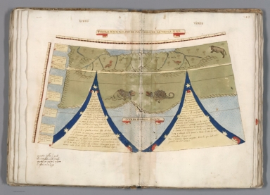
Author
Monte (Monti), Urbano, 1544-1613
Full Title
Tavola XXXXII. Che Ha Sua Superiore La Tavola. XXIIII. Libro Terzo.
List No
10130.044
Note
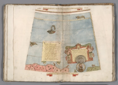
The legend on the left is a sonnet about the map and on the right side another legend in an elaborate frame explaining the shape of the world map and dating the work at 1587. Below the frame is an oval portrait of Monte at the age of 45, which covers another portrait of Monte slightly altered and at age 43. The existence of the top portrait at age 45 would indicate that some alternations of the 1587 work may have been made in 1789. This image shows the portrait age 45. See 10130.045 for the portrait age 43.
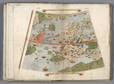
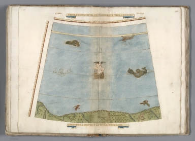
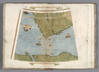
Author
Monte (Monti), Urbano, 1544-1613
Full Title
Tavola XXXXIII. Che Ha Sua Superiore La Tavola. XXV. Libro Terzo.
List No
10130.046
Note
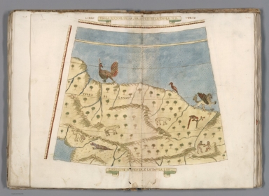
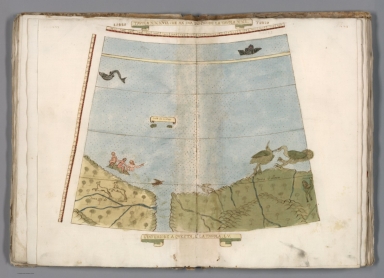
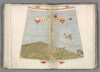
This and the other final 18 tables of the world map depict Antarctica peopled with fantastic creatures, imaginary islands, monsters, and many legends describing the various countries of the world.
Author
Greenleaf, Jeremiah
Full Title
Southern Hemisphere.
List No
15176.008
Note
Polar projection. Engraved. In full color by land mass. Meridian Greenwich.
Author
Du Val, Pierre, 1619-1683
Full Title
Terres dites Antarctiques autrement Australes et Inconnues.
List No
12503.021
Author
[Wyld, James, 1812-1887, Wyld, James, 1790-1836]
Full Title
Southern Hemisphere. London. Published by Jas. Wyld. (to accompany) A new general atlas of modern geography : consisting of a complete collection of maps of the four quarters of the globe ...
List No
13170.009
Note
Circular double page engraved map, hand colored in outline. Relief shown pictorially. Prime meridian is Greenwich.
Author
Stanford, Edward
Full Title
The Antarctic Regions.
List No
0949.013
Note
Countries in full color. Shows names of principal antarctic navigators and dates of exploration.
Author
Colton, G.W.
Full Title
Southern Regions.
List No
2441.009
Author
Rand McNally and Company
Full Title
North Polar Regions. South Polar Regions.
List No
2790.008
Note
Two maps on one sheet.
Author
[Stieler, Adolf, Petermann, A., Habenicht, H.]
Full Title
Nr. 6. Sued-Polar-Karte ... von A. Petermann.
List No
0962.017
Author
[Munster, Sebastian, 1448–1552, Ptolemy, Claudius, Pirckheimer, Willibald, 1470-1530]
Full Title
Typus Orbis Universalis. (to accompany) Geographia universalis, vetus et nova, complectens Claudii Ptolemaei Alexandrini enarrationis libros VIII ... Basileae apud Henricum Petrum Mense Martio anno M.D. XL (1540).
List No
11623.009
Note
Woodcut uncolored map of the world. The first map to name the pacific Ocean “Mare Pacificum”. Shows windheads around the map sea monsters, rivers and mountains. Relief shown pictorially.
Author
[Wytfliet, Corneille, Magini, Giovanni Antonio]
Full Title
Chica sive Patagonica et Australis Terra. (to accompany) Histoire universelle des Indes occidentales et orientales, et de la conversion des Indiens : divisee en trois parties par Cornille Wytfliet & Anthoine Magin & autres historiens. Premiere Partie. A Douay, Chez Francois Fabri, l'An 1611.
List No
11622.013
Note
Uncolored engraved double page map divided in two sections. Shows Strait of Magellan or Patagonia and at the bottom shows a polar view of the Terra Australis with Southern Africa and Madagascar. Relief shown pictorially. Includes decorative title cartouche.
Author
[Linschoten, Jan Huygen van, 1563-1611, Paludanus, Bernard, 1550-1633, Plancius, Petro, Doetecum, Jan van]
Full Title
Orbis Terrarum Typus de Integro Multis in Locis Emendatus. Carte generale de tout l'Unevers.
List No
12236.008
Note
Foldout. This map is among the first world maps to use highly decorated borders, setting a style of world maps that would continue for the next century.
Author
[Ptolemy, Claudius, Gastaldi, Giacomo, Mattioli, Pietro Andrea, 1500-1577, Pedrezano, Giovanbattista]
Full Title
Carta Marina Nova tabula. (to accompany) Ptolemeo. La geografia di Claudio Ptolemeo alessandrino ... In Venetia, ... per Gioan. Baptista Pedrezano ... Anni x. M.D.XLVIII (1548).
List No
11479.131
Note
Engraved nautical chart of the world with coastal detail. The chart shows America and Asia connected as one land mass. Montagna Verde appears in NY State. Tierra Del Bacalaos, Tierra el Laborador shown in North America. Tierra Del Fuego in the south. Africa shown in detail with place names. Place names shown in Mexico, Brazil and Peru.
Author
Blaeu, Willem Janszoon, 1571-1638
Full Title
Nova Totius Terrarum Orbis Geographica ac Hydrographica Tabula.
List No
12202.003
Author
Ortelius, Abraham, 1527-1598
Full Title
Typus Orbis Terrarum. Franciscus Hogenbergus sculpsit. Cum Privilegio. Quid ei potest videri magnum in rebus humanis, cui aeternitas omnis, totiusque magnitudo. Cicero:
List No
10000.011
Author
Ortelius, Abraham, 1527-1598
Full Title
Americae Sive Novi Orbis, Nova Descriptio.Cum Privilegio.
List No
10000.013
Author
Brue, Adrien Hubert, 1786-1832
Full Title
Mappemonde projetee sur l'horizon de Paris et sur son antipode. Mappemonde sur la projection polaire. Dressees par A. Brue, Geographe du Roi. Paris, 1828. Chez l'Auteur, rue des Macons-Sorbonne, no. 9, et chez les principaux marchands de cartes geographiques.
List No
0096.017
Note
Two hand colored engraved maps. Prime meridian: Paris. Contents: Hemisphere sur l'horizon de Paris -- Hemisphere sur l'horizon de l'antipode de Paris -- Hemisphere boreal -- Hemisphere austral.
Author
Colton, G.W.
Full Title
Southern Regions. Published by J.H. Colton And Co. 172 William St. New York. Entered ... 1855 by J.H. Colton & Co. ... New York. No. XIII.
List No
0149.010
Note
Antarctica using a polar projection. Routes of the explorers shown including dates of exploration. Uncolored.
Author
Colton, G.W.
Full Title
Northern Regions. Southern Regions. Published by J. H. Colton. No. 172 William St. New York.
List No
0151.015
Note
Map showing Arctic and Antarctic Regions. Prime meridians are Greenwich and Washington D. C. Printed in black and white.
Author
Colton, G.W.
Full Title
Northern Regions. Southern Regions. Published by G. W & C. B. Colton & Co., No. 172 William St. New York.
List No
0152.014
Note
Map showing Arctic and Antarctic Regions. Prime meridians are Greenwich and Washington D.C.
Author
Pinkerton, John, 1758-1826
Full Title
Southern Hemisphere. Drawn under the direction of Mr. Pinkerton by L. Hebert. Neele sculpt. 352 Strand. London: published August 31st. 1812 by Cadell & Davies, Strand & Longman, Hurst, Rees, Orme, & Brown, Paternoster Row.
List No
0732.004
Note
Engraved map. Full hand col. Relief shown by hachures. "Pinkerton's modern atlas."
Author
Polish Army Topography Service
Full Title
Atlantic Ocean. Antarctica. Pergamon World Atlas. Pergamon Press, Ltd. & P.W.N. Poland 1967. Sluzba Topograficzna W.P.
List No
0737.049
Note
Shows ocean currents, bathymetry, and topography. Antarctica map at 1:20,000,000 shows routes of scientific expeditions before 1957, bathymetry, topography, and ownership.
Author
Raisz, Erwin
Full Title
Arctica. (and) Antarctica. (inset) The Arctic Winter. (inset) Greenland. (inset) Shelf Ice. (to accompany) Atlas Of Global Geography. By Erwin Raisz. Lectures in Cartography, Institute Of Geographical Exploration, Harvard University, Cambridge, Mass. ... Global Press Corporation, Publishers. New York, N.Y. Sole Distributors: Harper & Brothers, New York. (on verso) Copyright 1944, by Global Press Corporation.
List No
0744.015
Note
Color maps. Accompanied by text. With paper dust jacket. On the jacket it states that this is an "entirely new kind of atlas - A beautiful and informative book of 'global' maps, giving a plane's-eye view of tomorrow's geography..."
Author
Society for the Diffusion of Useful Knowledge (Great Britain)
Full Title
(World on gnomonic projection. VI. From South Pole to 450 S. Lat.). No.6. Published by Baldwin & Cradock, 47 Paternoster Row June 1831. Under the superintendence of the Society for the Diffusion of Useful Knowledge. Engraved by J. & C. Walker.
List No
0890.009
Note
Engraved map. No. 6 of 6 sheets. Country boundaries hand col. Relief shown by hachures. Shows tidal information including cotidal isolines. Issued earlier and separately. Title from contents page.
Author
Society for the Diffusion of Useful Knowledge (Great Britain)
Full Title
South America sheet V. Patagonia. (with) Isle of Georgia. (with) The South Shetlands and Orkneys. Published under the superintendence of the Society for the Diffusion of Useful Knowledge. Engraved by J. & C. Walker. London, published by Chapman & Hall, 186 Strand, April 2nd, 1838. (1844) Printed by J. & C. Walker.
List No
0890.152
Note
Engraved map. Relief shown by hachures and spot heights. Boundaries hand col. Covers also the Falkland Islands. David Rumsey Collection copy incorrectly bound in atlas as no. 154 (should be 153)
Author
[Stieler, Adolf, Petermann, A.]
Full Title
Stieler's Hand-Atlas ... No. 42a. Sud-Polar-Karte.
List No
0960.079
Note
Shows routes of marine exploration.
Author
[Stieler, Adolf, Petermann, A., Habenicht, H.]
Full Title
6. Sued-Polar-Karte.
List No
0961.017
Author
[Ortelius, Abraham, 1527-1598, Vrients, Jan Baptista]
Full Title
Maris Pacifici, (quod vulg�� Mar del Zur) cum regionibus circumiacentibus, insulisque in eodem passim sparsis, novissima descriptio. Cum privilegiis Imp. & Reg. Maiestatum, nec non Cancellariae Brabantiae, ad decennium. Spe Et Metv Genio Et Ingenio Nobili Dn. Nicolao Roccoxio, Patricio Antverpiensi, Eivsdemqve Vrbis Senatori, Abrahamus Ortelius Regi�� Mts. geographus sub. merito dedicabat. 1589.
List No
10001.067
Author
Thomson, John
Full Title
Southern Hemisphere. Kirkwood sculp. Drawn & engraved for John Thompson Co.'s New general atlas, 12 August 1814.
List No
1007.004
Note
Engraved map. Hand colored. Relief shown pictorially.
Author
[Buchanan, George, Thomson, John]
Full Title
Southern Hemisphere projected on the plane of the horizon of London. By Geo. Buchanan. J. & G. Menzies sculpt., Edinr. Projected & engraved for Thomson's New general atlas, 20th Sept. 1816.
List No
1007.008
Note
Engraved map. Outline hand color. Relief shown by hachures. "N.B. The scale only measures with sufficient accuracy distances in the direction of the meridians."
Full Title
Polynesian Groups (composed of) Fiji, Viti, Islands; Sandwich, Hawaii, Islands; Samoa or Navigator Islands. South Polar Regions. (with) Kerguelen Island. (with) Victoria Land. (Published at the office of "The Times," London, 1895)
List No
1010.075
Note
Four color maps with 3 insets. Relief shown by hachures and spot heights. Show settlements, etc. Includes inset of "County of Rutland" for comparison.
Author
[Touring club italiano, Funk & Wagnalls Company.]
Full Title
Terre polari. (Propr. Artistico-letteraria del T.C.I. Ufficio cartografico del T.C.I. 1929)
List No
1012.002
Note
Two color maps. Relief shown by spot heights.
Author
Monte (Monti), Urbano, 1544-1613
Full Title
Tavola XVIII. Che Ha Sua Superiore La Tavola Ottava. Libro Terzo.
List No
10130.020
Author
Monte (Monti), Urbano, 1544-1613
Full Title
Tavola XVIIII. Che Ha Sua Superiore La Tavola Nonaa. Libro Terzo.
List No
10130.021
Author
Monte (Monti), Urbano, 1544-1613
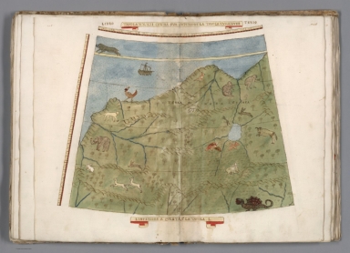
Full Title
Tavola XXVI. Che Ha Sua Superiore La Tavola. XIII. E.XIIII. Libro Terzo.
List No
10130.028
Author
Monte (Monti), Urbano, 1544-1613
Full Title
Tavola XXVII. Che Ha Sua Superiore La Tavola. XIIII. Libro Terzo.
List No
10130.029
Author
Monte (Monti), Urbano, 1544-1613
Full Title
Tavola XXVIII. Che Ha Sua Superiore La Tavola. XV. Libro Terzo.
List No
10130.030
Author
Monte (Monti), Urbano, 1544-1613
Full Title
Tavola XXVIIII. Che Ha Sua Superiore La Tavola. XV. E.XVI. Libro Terzo.
List No
10130.031
Author
Monte (Monti), Urbano, 1544-1613
Full Title
Tavola XXX. Che Ha Sua Superiore La Tavola .XVI. Libro Terzo.
List No
10130.032
Author
Monte (Monti), Urbano, 1544-1613
Full Title
Tavola XXXI. Che Ha Sua Superiore La Tavola .XVII. Libro Terzo.
List No
10130.033
Author
Monte (Monti), Urbano, 1544-1613
Full Title
Tavola XXXII. Che Ha Sua Superiore La Tavola .XVII. E.XVIII. Libro Terzo.
List No
10130.034
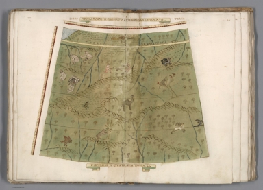
Author
Monte (Monti), Urbano, 1544-1613
Full Title
vola XXXIII. Che Ha Sua Superiore La Tavola. XVIII. Libro Terzo.
List No
10130.035
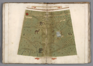
Author
Monte (Monti), Urbano, 1544-1613
Full Title
Tavola XXXIIII. Che Ha Sua Superiore La Tavola. XVIIII. Libro Terzo.
List No
10130.036
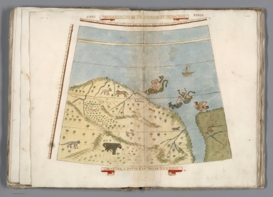
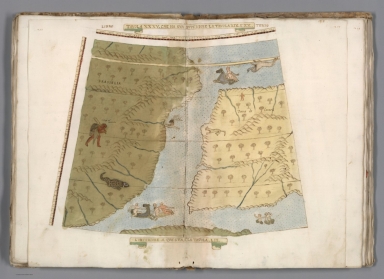
Author
Monte (Monti), Urbano, 1544-1613
Full Title
Tavola XXXV. Che Ha Sua Superiore La Tavola. XIX. E.XX.. Libro Terzo.
List No
10130.037
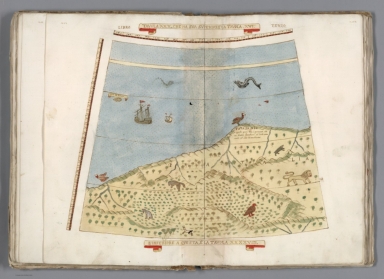
Author
Monte (Monti), Urbano, 1544-1613
Full Title
Tavola XXXVI. Che Ha Sua Superiore La Tavola. XX. Libro Terzo.
List No
10130.038
Author
Monte (Monti), Urbano, 1544-1613
Full Title
Tavola XXXVII. Che Ha Sua Superiore La Tavola. XXI. Libro Terzo.
List No
10130.039
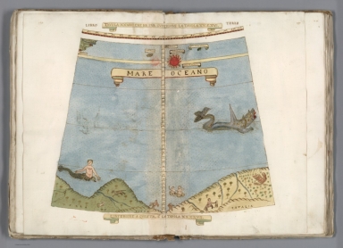
Author
Monte (Monti), Urbano, 1544-1613
Full Title
Tavola XXXVIII. Che Ha Sua Superiore La Tavola. XXI. E.XXII. Libro Terzo.
List No
10130.040
Author
Monte (Monti), Urbano, 1544-1613
Full Title
Tavola XXXVIIII. Che Ha Sua Superiore La Tavola. XXII. Libro Terzo.
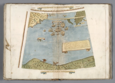
List No
10130.041
Note
The long legend describes the first circumnavigation of the globe by Magellan, 1519-1522.
Author
Monte (Monti), Urbano, 1544-1613
Full Title
Tavola XXXXII. Che Ha Sua Superiore La Tavola. XXIIII. Libro Terzo.
List No
10130.045
Note
The legend on the left is a sonnet about the map and on the right side another legend in an elaborate frame explaining the shape of the world map and dating the work at 1587. Below the frame is an oval portrait of Monte at the age of 45, which covers another portrait of Monte slightly altered and at age 43. The existence of the top portrait at age 45 would indicate that some alternations of the 1587 work may have been made in 1789. This image shows the portrait age 43. See 10130.044 for the portrait age 45.
|