|
REFINE
Browse All : World Atlas of America and United States
1-3 of 3
Author
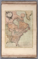
[Reilly, Franz Johann Joseph von (1766-1820), Kininger, Vinzenz Georg]
Full Title
Karte von Amerika. Nach d'Anville und Pownall. Neu verzeichnet herausgegeben von Franz Joh. Jos. von Reilly. Zu finden im von Reilly'schen Landkarten und Kunstwerke Verschleiss Komptoir. Wien, 1795. Gestochen von Kil. Ponheimer. (insets) Karte von der Republik der Vereingten Dreyzehen Staaten in Nord Amerika. (with) Das Nordliche Polarland. (with untitled insets) (Alaska and portion of Russia). (to accompany) Grosser Deutscher Atlas.
List No
11151.009
Note
Double page engraved hand color map of America. Engraved by Kilian Ponheimer. Main map shows "Quivira" as northwestern region of modern-day United States. Northern California is marked as New Albion or "Neu Albion." Along the far northwest coast of North America are notes about geographical discoveries, explorers' landings and dates including Sir Francis Drake and Captain George Dixon. Shows Native American tribes settlements throughout the map. Includes 3 insets of the United States and Canada. Shows political boundaries, capitals, cities and towns. Includes text at top of inset map of Alaska. Inset map of the United States shows several states including "Georgien" "Sud Carolina" "Nord Carolina" "Virginien," "Pennsylvanien" "Neu York", Massachusets" "Connecticut" and "Neu Main. Inset map of the North Pole covers Greenland, Hudson's Bay and Baffin's Bay. Relief shown pictorially.
Author
[Lattre, Jean, 1743 -1793, Bonne, Rigobert, 1727-1794]
Full Title
Partie de l'Amerique Septentrionale : qui comprend le Canada, la Louisiane, le Labrador, le Groenland, les Etats-Unis et la Floride &c. Par Mr. Bonne. 1776. (to accompany) Atlas Geographique contenant la Mappemonde et les quatre parties, avec les differents Etats, avec apprpbation & privilage du Roy MDCC.LXIII (1763).
List No
11335.042
Note
Engraved outlined hand color map. Includes place names, and descriptive notes. Relief shown pictorially. Sheets also numbered XXXIV.
Author
Legrand, Augustin
Full Title
Exposition geographique XIV Tableau : Amerique. 2me. Degre d'enseignement. 3me. Partie. (to accompany) 1839 Exposition geographique ... Par Augustin Legrand ... Paris. (insets) Supplement pour les Etats- Unis. (with) Les Antillrd : Carte Supplementaire. (with) Oceanie: Monde maritime 5me. Section.
List No
13118.015
Note
Hand colored in outline map of America. Shows political and administrative boundaries, capitals, major cities and rivers. Includes notes. Relief shown by hachures and pictorially. Prime meridian is Paris. Includes color coded key to European possessions in West Indies and Oceania.
1-3 of 3
|