|
Author
[Depot General de la Marine, Tofino de San Miguel, Vicente, 1732-1795]
Full Title
Carte Du Detroit De Gibraltar
List No
15934.205
Note
Hydrographie Française 5
Author
Depot General de la Marine
Full Title
Cote Meridionale D'Espagne depuis Cadiz jusqu'au Cap de Palos et Cote Septentrionale D'Afrique
List No
15934.210
Note
Hydrographie Française 5
Author
Arrowsmith, John, 1790-1873
Full Title
(Composite map of) Map of the West coast of Africa comprising Guinea, and the British possessions at Sierra Leone, on the Gambia and the Gold Coast, together with the countries within the courses of the rivers Senegal, Gambia & Kowara, compiled from official documents, by J. Arrowsmith, 1858. London. Pubd. 17th April 1858, by John Arrowsmith, 10 Soho Square.
List No
14506.042
Note
Composite map representing West Africa. Shows political boundaries, cities, roads, topography, deserts, bodies of water, drainage, coastlines, and islands. Relief shown with hachures. Includes latitudinal and longitudinal lines. Hand-colored engraving.
Author
[Hughes, William, 1818-1876, Weller, Edward, 1819-1884]
Full Title
Africa. By Edwd. Weller, F.R.G.S. George Philip & Son, London & Liverpool.
List No
14487.031
Note
Map representing Africa. Shows political boundaries, cities, topography, bodies of water, drainage, and coastlines. Relief shown with hachures. Includes latitudinal and longitudinal lines, as well as bar scales given in English miles and kilometers. Colored lithograph. Map is 53 x 61 cm, on double sheet 56 x 70 cm.
Author
Logerot, A. (Auguste)
Full Title
Afrique. A. Logerot ; Ce 8 Janvier 1856.
List No
14489.041
Note
Manuscript map representing Africa. Shows select regions, cities, mountain ranges, deserts, drainage, coastlines, and islands. Relief shown with shading. Ink, pencil, and watercolor on paper. Map is 22 x 28 cm, on sheet 24 x 31 cm. (Page number written as “43” for page 44 in volume.)
Author
Blondeau, active 18th century-19th century
Full Title
Afrique. Blondeau sculp.
List No
14318.006
Note
Map of Africa. Shows continental and national boundaries, cities, topography, vegetation, deserts, coastlines, major lakes, drainage and islands. Relief shown pictorially. Includes latitudinal and longitudinal lines. Hand-colored engraving. Map is 19 x 22 cm, on sheet 22 x 26 cm.
Author
Andriveau-Goujon, Eugene
Full Title
Afrique. Paris - 1862. E. Andriveau-Goujon. Rue du Bac. 21. Impie. de Louis Antoine. Gravee par Smith et Gerin. (to accompany) Atlas classique et universel de geograparphie ancienne et moderne ... Nouvelle edition. 1863.
List No
13421.054
Note
Hand color map. Relief shown by hachures. Includes color coded reference to European colonies.
Author
Andriveau-Goujon, Eugene
Full Title
(Composite Map) Algerie, d'apres les cartes de l'Etat-major et les documents du Ministere de la Guerre. E. Andriveau-Goujon, Editeur. Paris, Rue du Bac. 21.1862. Paris, Impie. de Louis Antoine. Gravee par Ms. Gerin, Dalmont, Smith et Fontaine. (to accompany) Atlas classique et universel de geograparphie ancienne et moderne ... Nouvelle edition. 1863.
List No
13421.057
Note
Composite map of sheets 43-44: Algerie.
Author
Andriveau-Goujon, E. (Eugène), 1832-1897
Full Title
(19) Carte générale de l'Afrique d'après les derraeres découvertes. Publiée par E. Andriveau-Goujon, 4, Rue du Bac, Paris, 1881. Nouvelle edition. Gravée par Smith et Gérin; les ecritures par P. Rousset.
List No
14008.023
Note
Hand-colored, engraved map of Africa, showing showing political boundaries, roads and railroads (on double plate with decorative border). Includes legend indicating colonies (English, French, Spanish, Portuguese and of the Sultan of Zanzibar), as well as 5 bar scales. "No. 20" in upper right. With 8 insets: (Iles Canaries) -- (Madère) -- (Iles du Cap Vért) -- (Ile de l'Ascension) -- (Ile Ste. Hélène) -- (Ile Mayotte) -- (Iles Nossi-Be) -- (Iles Mascareignes).
Author
W. & A.K. Johnston Limited
Full Title
Africa. Edinburgh: W. & A.K. Johnston ; Glasgow: Robert Weir ; Lumsden & Son.
List No
14296.045
Note
Map of Africa and vicinity. Shows political boundaries, cities, routes, topography, deserts, drainage, coastlines and islands. Relief shown pictorially. Includes latitudinal and longitudinal lines, as well as a bar scale. "Long. W. from Greenwich." With a statistical table featuring surface area, population and religion. Map is 29 x 21 cm, on sheet 35 x 27 cm. Hand-colored engraving. In second section of atlas, Modern maps.
Author
Philip, George, 1870-1937.
Full Title
Africa.
List No
15487.096
Author
Philip, George, 1870-1937.
Full Title
Central Africa.
List No
15487.099
Author
Elwe, Jan Barend
Full Title
L'Afrique divisée en ses Empire Royaumes et Etats dressées sur les dernieres observations. A Amsterdam. Chés J. B. Elwe. MDCCXCII.
List No
14478.049
Note
Map of Africa and vicinity. Shows countries, regions, cities, topography, vegetation, deserts, bodies of water, drainage, coastlines and islands. Relief shown pictorially. Includes six bar scales, latitudinal and longitudinal lines. With decorative cartouches. Hand-colored engraving. Map is 44 x 57 cm, on double sheet 58 x 70 cm.
Author
[U.S. Coast and Geodetic Survey, U.S. Army Air Forces]
Full Title
North Central Africa
List No
15328.008
Author
Pistacchi, Andre
Full Title
Africa. Africa map by Andrea Pistacchi.
List No
14405.002
Note
Pictorial map of Africa, depicting adventures of the character Corto Maltese. Also shows indigenous territories, cities, routes, topography, deserts, bodies of water, drainage, coastlines and islands. Relief shown with hachures. Features illustrations of people, animals and plants. Includes numerous inset maps of various types, as well as images of stamps and other ephemera surrounding the continent. With vignette portraits of historical and literary figures, such as David Livingstone and Lawrence of Arabia. Descriptive text throughout, including notes on colonial explorations. Colored lithograph. Map is 64 x 68 cm, on sheet 69 x 74 cm, folded to 23 x 19 cm. "Allegato al n. 2 di Corto Maltese 1986 ... "
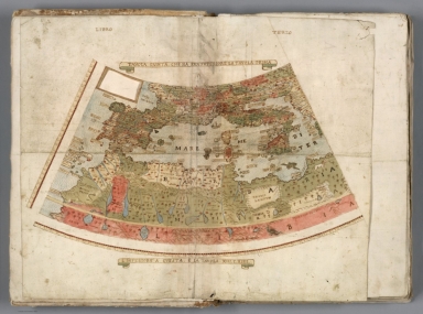
Author
Monte (Monti), Urbano, 1544-1613
Full Title
Tavola Quinta, Che Ha Sua Superiore La Tavola Prima. Libro Terzo.
List No
10130.007
Note
The note box has been cut out, indicating perhaps an intended revision that did not occur.
Author
[3, Soviet Union. Glavnoe upravlenie geodezii i kartografii]
Full Title
Африка, Физическая = Afrika, Fizicheskaia. 191-192. Atlas Mira : 1954.
List No
13682.205
Note
Physical map of Africa. Relief shown by gradient tints, contours and spot heights. Depths shown by gradient tints, isolines and soundings.
Author
[Faden, William, 1749-1836, Anville, Jean Baptiste Bourguignon d, 1697-1782, Boulton, S.]
Full Title
(Composite Map to) Africa, with all its states, kingdoms, republics, regions, islands, &ca. Improved and inlarged from d'Anville''s Map; to which have been added a particular chart of the Gold Coast, wherein are distinguished all the European forts and factories, by S. Boulton, and also a summary description relative to the trade and natural produce, manners and customs of the African continent and islands. London, published by Laurie & Whittle, No. 53 Fleet-Street, as the Act directs, 12th May, 1794.
List No
14383.050
Note
Composite map of Africa, as of 1794. Shows political boundaries, cities, roads, topography, bodies of water, drainage, coastlines and islands. Relief shown pictorially. Includes latitudinal and longitudinal lines, as well as seven bar scales and arrows indicating the direction of ocean currents. With two inset maps: Azores -- A particular chart of the Gold Coast. Decorative cartouche. Descriptive text throughout, including notes on exploration and other history. Hand-colored engraving. Map is 104 x 122 cm, on two fold-out sheets, together 110 x 131 cm. With stamp: Liverpool Library.
Author
Berey, Nicolas
Full Title
Carte L'Afrique Corrigee, et augmentee, desus toutes les aultres cy devant faictes .
List No
15185.005
Author
Weiland, C. F. (Carl Ferdinand), 1782-1847
Full Title
Africa entworfen und gezeichnet von C. F. Weiland. Weimar, im Verlag des Geogr. Instituts, 1827.
List No
14365.050
Note
Map of Africa, as of 1827. Shows political boundaries (including European colonies), cities, topography, deserts, bodies of water, drainage, coastlines, shoals and islands. Relief shown with hachures. Includes latitudinal and longitudinal lines, as well as a legend, three bar scales and descriptive text throughout. Hand-colored engraving. Map is 32 x 38 cm, on sheet 45 x 57 cm. (Plate number taken from table of contents.)
Author
Desilver, Roberto
Full Title
Africa.
List No
14368.007
Note
Map of Africa. Shows political boundaries, cities, topography, bodies of water, drainage, coastlines and islands. Relief shown pictorially. Includes latitudinal and longitudinal lines, as well as a bar scale and compass rose with north oriented toward top of sheet. With title cartouche. Hand-colored engraving. Map is 33 x 35 cm, on double sheet 45 x 55 cm.
Author
[Portugal. Ministério das Colónias, Portugal. Junta de Investigações Coloniais]
Full Title
Viagens marítimas de descobrimento ao longo da costa ocidental da África. Gravada e impressa no Instituto Geographico e Cadastral, em 1946. Ministério das Colónias, Junta das Missões Geográficas e de Investigações Coloniais.
List No
14369.010
Note
Map of Africa, featuring maritime voyages of Portuguese exploration along the west coast. Also shows cities, bodies of water, drainage, coastlines and islands. Includes latitudinal and longitudinal lines, as well as explanatory notes. Colored lithograph. Map is 35 x 24 cm, on sheet 48 x 34 cm.
Author
Munster, Sebastian, 1448–1552
Full Title
Africae Tabula
List No
15058.051
Author
[Raif Efendi, Mahmud, Faden, William (1749-1836)]
Full Title
(Africa)
List No
15054.063
Note
For the source map by Faden see https://www.davidrumsey.com/luna/servlet/s/w67781
Author
[Ptolemy, Claudius, Mercator, Gerhard, 1512-1594, Pirckheimer, Willibald, Mylius, Arnold]
Full Title
AFRICAE: I. TAB
List No
10991.180
Note
Hand colored outline map of North Africa. Showing landmarks, major cities and towns, rivers and parks. Relief shown pictorially.
Author
[Ptolemy, Claudius, Mercator, Gerhard, 1512-1594, Pirckheimer, Willibald, Mylius, Arnold]
Full Title
AFR: II. TAB
List No
10991.182
Note
Hand colored outline map of North Africa. Showing landmarks, major cities and towns, rivers and parks. Relief shown pictorially.
Author
[Ptolemy, Claudius, Mercator, Gerhard, 1512-1594, Pirckheimer, Willibald, Mylius, Arnold]
Full Title
AFR: III. TAB
List No
10991.184
Note
Hand colored outline map of North Africa. Showing landmarks, major cities and towns, rivers and parks. Relief shown pictorially.
Author
[Ptolemy, Claudius, Mercator, Gerhard, 1512-1594, Pirckheimer, Willibald, Mylius, Arnold]
Full Title
APPENDIX III. TABVLAE AFR.
List No
10991.185
Note
Hand colored outline map of North Africa. Showing landmarks, major cities and towns, rivers and parks. Relief shown pictorially.
Author
[Ptolemy, Claudius, Mercator, Gerhard, 1512-1594, Pirckheimer, Willibald, Mylius, Arnold]
Full Title
AFR: IIII. TAB
List No
10991.187
Author
[Nolin, Jean Baptiste, 1648-1708, Coronelli, Vincenzo (1650-1718), Du Tralage, Jean Nicolas, -169]
Full Title
Afrique selon les Relations les plus Nouvelles dresseé et dediée par le P. Coronelli Cosmographe de la Serenissime Republique de Venise. Corrigée et augmentée par le Sr. Tillemon. A Monseigneur le Duc de Brissac Pair de France. A Paris, Chez Jean Baptiste Nolin, sur le Quay de l’Horloge du Palais Vers le Pont Neuf, à l'enseigne de la Place des Victoires. Avec Privilege du Roy. 1689.
List No
14353.045
Note
Map of Africa. Title translates to: Africa according to the most recent revelations. Shows political boundaries, cities, topography, deserts, lakes, drainage, coastlines, shoals and islands. Relief shown pictorially. Includes latitudinal and longitudinal lines, as well as a legend, six bar scales and explanatory notes. Decorative cartouche with indigenous figure and fauna. Black and white engraving with hand-colored borders. Map is 44 x 59 cm, on double sheet 50 x 67 cm. (Plate number handwritten in ink on verso.)
Author
Vuillemin, Alexandre
Full Title
Geographie commercial et industriel : Nouvelle carte illustree de l'Afrique : presentant les grandes divisions physiques, la distribution geographique des vegetaux et des minéraux, les ports de commerce, villes industrielles et fortifiees des differents etats. Dressee par A. Vuillemin. Gravee par Langevin. Paris, Chez Fatout, Editeur. 1857. Grave sur acier, la topographie par Gerin, le trait au burin par F. Lefevre, Les illustrations dessinees par A. Testard et gravees par Guesnu. Imp. par Mangeon. Paris. (to accompany) Atlas de geographie commercial et industriel.
List No
13375.005
Note
Engraved outline hand color map of Africa. Includes 18 vignette views of different countries in Africa and 2 sections of fruits and plants in panels at sides. Includes tables, legend and notes.
Author
Society for the Diffusion of Useful Knowledge (Great Britain)
Full Title
Africa.
List No
10911.064
Author
[Pasa, Ali Seref, Esref, Hafiz Ali]
Full Title
Afrika Kıtası = Continent of Africa. 1309 (1893). Tabie ve Nnashiri Hasan Ferid.(to accompany) Yeni cografya atlasi - ىگى جغرافىا آطلسى = New geographical atlas. Dersa'adet (Istanbul), 1307-1309 (1891-1893).
List No
13621.007
Note
Map of Africa, shows political boundaries.
Author
[Pasa, Ali Seref, Esref, Hafiz Ali]
Full Title
(West Africa) (to accompany) Yeni cografya atlasi - ىگى جغرافىا آطلسى = New geographical atlas. Dersa'adet (Istanbul), 1307-1309 (1891-1893).
List No
13621.031
Author
Hafız Ali Eşref
Full Title
Afriqa = Africa. (to accompany) Yeni atlas = First atlas. Mülâzim-i evvel Hafız Ali Eşref. Paris. 1285 (1868).
List No
13529.008
Note
Color map. Shows political boundaries.
Author
Silishchensky, Mitrofan Ivanovich 1878 - 1944
Full Title
Afrika. Ekonomichesko-Politicheskaia karta. Prof. M. I. Silishchenskiy. Gos. Kartogr. Institut NTU-VSNKH-SSR. Kartografiya Leningrad. (to accompany) Geograficheskiy atlas Chast 1.
List No
13461.026
Note
Economical and political map of Africa. Includes legend and color coded key.
Author
Abdulqader, M.
Full Title
Afrika = Africa. (to accompany) Küçük Coğrafya = (School atlas of geography). ikinci kisim. Murtabi M. Abdulqader. 1325 (1907).
List No
13530.017
Note
Color map of Africa. Shows political boundaries, major cities, rivers and mountains. Relief shown by hachures. Includes vignettes of flags of various African countries.
Author
Abdulqader, M.
Full Title
(Text Page to) Afrika-i Osmanî.ve Arabistan = Ottoman Empire in Africa and Arabia. (to accompany) Küçük Coğrafya = (School atlas of geography). ikinci kisim. Murtabi M. Abdulqader. 1325 (1907).
List No
13530.018
Note
Descriptive text to Ottoman Empire in Africa and Arabia.
Author
Abdulqader, M.
Full Title
Afrika-i Osmanî. = Ottoman Empire in Africa. (to accompany) Küçük Coğrafya = (School atlas of geography). ikinci kisim. Murtabi M. Abdulqader. 1325 (1907).
List No
13530.019
Note
Color map of Ottoman Empire in Africa. Shows political boundaries, major cities, rivers and mountains. Relief shown by hachures. Includes vignettes of traditional costumes and Ottoman flag.
Author
Abdulqader, M.
Full Title
(Text Page to) Memalik Osomania = Ottoman Empire. (to accompany) Küçük Coğrafya = (School atlas of geography). ikinci kisim. Murtabi M. Abdulqader. 1325 (1907).
List No
13530.020
Note
Descriptive text to Ottoman Empire.
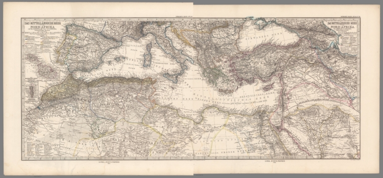
Author
Stieler, Adolf, 1775–1836
Full Title
(Composite of) Das Mittellandische Meer Und Nord-Afrika Im Maassstabe von 1:7.500.000. Von A. Petermann. Stieler's Hand-Atlas. Von A. Petermann. Gotha : Justus Perthes. 1875.
List No
13563.021
Note
Composite map of nos. 13-14 of Mediterranean region, Southern Europe and Northern Africa and Southwest Asia. Three inset maps show Malta, Gibraltar, and the Nile Delta and Isthmus of Suez.
Author
[Lizars, William Home, 1788-1859, Lizars, Daniel]
Full Title
Taken from the most celebrated modern geographers : Africa. Corrected to present period by astronomical observations. D. Lizars script. et sculpt. Published by T. Brown & W. & D. Lizars, Edinbr. (to accompany) New Edinburgh general atlas ... The maps drawn and engraved by W. & D. Lizars.
List No
13230.047
Note
Hand colored engraved map on 4 sheets. Relief shown by hachures and pictorially. Prime meridian is Greenwich.
Author
[Lizars, William Home, 1788-1859, Lizars, Daniel]
Full Title
Egypt. Published by T. Brown & W. & D. Lizars, Edinburgh. (to accompany) New Edinburgh general atlas ... The maps drawn and engraved by W. & D. Lizars.
List No
13230.048
Note
Hand colored engraved map, with inset map: Delta enlarged. Relief shown by hachures. Prime meridian is Greenwich.
Author
Willdey, George
Full Title
Africa : corrected from observations of Mess. of ye Royal Societies at London and Paris. By C. Price. 1711. Sold by George Willdey.
List No
13539.007
Note
Engraved hand color in outline map of Africa, with uncolored decorative title cartouche depicting animals. Inset views of natives, flora and fauna and advertisement for Willdey's instruments and trade goods. made and sold by George Willdey. Includes dedication with decorative cartouche and annotations.
Author
[Mercator, Gerhard, 1512-1594, Hondius, Jodocus, 1563-1612, Hondius, Hendrik, 1597-1651]
Full Title
Africa Ex magna orbis terre descriptione. Gerardi Mercatoris desumpta, Studio & Iunioris. Cum Privilegio.
List No
10534.033
Author
[Mercator, Gerhard, 1512-1594, Hondius, Jodocus, 1563-1612, Hondius, Hendrik, 1597-1651]
Full Title
Nova Africae Tabula. Auctore Jodoco Hondio Excusum in aedibus Auctoris Amsterodami.
List No
10534.321
Author
[Lattre, Jean, 1743 -1793, Janvier, Jean Denis]
Full Title
L'Afrique : divisee en ses principaux etats. Par le Sr. Janvier. A Paris, Chez Lattre Graveur. 1762. (to accompany) Atlas moderne ou collection de cartes sur toutes les parties du globe terrestre.
List No
13420.035
Note
Engraved outlined hand color map. Shows political boundaries and place names. Relief shown pictorially. Includes ornamental title cartouche.
Author
[Mercator, Gerhard, 1512-1594, Hondius, Jodocus, 1563-1612]
Full Title
Africa Ex magna orbis terre descriptione. Gerardi Mercatoris desumpta, Studio & Iunioris. Cum Privilegio.
List No
10501.052
Author
[Mercator, Gerhard, 1512-1594, Hondius, Jodocus, 1563-1612]
Full Title
Nova Africae Tabula. Auctore Jodoco Hondio Excusum in aedibus Auctoris Amsterodami.
List No
10501.452
Author
[Stieler, Adolf, Lueddecke, R.]
Full Title
(Composite Map) Afrika in 6 Blaetten.
List No
2207.040
|