|
Author
Andriveau-Goujon, Eugene
Full Title
Mappemonde en deux hemispheres. 1862. Publiee par E. Andriveau-Goujon, Rue du Bac. 21. Paris. Grave par Ch. Dyonette. Ecrit par P. Rousset. Impie. de Louis Antoine. (to accompany) Atlas classique et universel de geographie ancienne et moderne ... Nouvelle edition. 1863.
List No
13421.022
Note
Hand color folded double atmosphere map of the world. Shows European colonies. Relief shown by hachures.
Author
Andriveau-Goujon, Eugene
Full Title
Palestine ancienne & moderne, d'apres les sources les plus authentiques. Par E. Andriveau. Paris - 1862. E. Andriveau-Goujon. Rue du Bac. 21. Paris, Imprimie. de Louis Antoine. Grave le trait et les montagnes par Gérin; les Ecritures par P. Rousset. Les Eaux par Mme. Fontaine. (to accompany) Atlas classique et universel de geograparphie ancienne et moderne ... Nouvelle edition. 1863.
List No
13421.047
Note
Hand color map. Insets:Sinai -- Golfe de Suez -- Cross section of the Palestine from the source of the Jordan to the Red Sea -- Panoramic view of the mountains of Palestine -- Jeusalem d'apres le plan de G. Williams. Covers portions of Israel, Jordan, Syria and Lebanon. Shows roads and trails. Relief shown by hachures. Includes tables and text.
Author
Andriveau-Goujon, Eugene
Full Title
(Composite Map) Asie Orientale comprenant L'Empire Chinois et le Japon, les Etats de L'Indo-Chine et le Grand Archipel d'Asie. (to accompany) Atlas classique et universel de geograparphie ancienne et moderne ... Nouvelle edition. 1863.
List No
13421.051
Note
Composite map of sheets 38-39: Asie Orientale.
Author
Andriveau-Goujon, Eugene
Full Title
Afrique. Paris - 1862. E. Andriveau-Goujon. Rue du Bac. 21. Impie. de Louis Antoine. Gravee par Smith et Gerin. (to accompany) Atlas classique et universel de geograparphie ancienne et moderne ... Nouvelle edition. 1863.
List No
13421.054
Note
Hand color map. Relief shown by hachures. Includes color coded reference to European colonies.
Author
Andriveau-Goujon, Eugene
Full Title
(Composite Map) Algerie, d'apres les cartes de l'Etat-major et les documents du Ministere de la Guerre. E. Andriveau-Goujon, Editeur. Paris, Rue du Bac. 21.1862. Paris, Impie. de Louis Antoine. Gravee par Ms. Gerin, Dalmont, Smith et Fontaine. (to accompany) Atlas classique et universel de geograparphie ancienne et moderne ... Nouvelle edition. 1863.
List No
13421.057
Note
Composite map of sheets 43-44: Algerie.
Author
Andriveau-Goujon, Eugene
Full Title
(Composite Map) Carte Generale des Etats - Unis et du Mexique : Comprenant L'Amerique Centrale Et Les Antilles. E. Andriveau-Goujon, Editeur. Paris, Rue Du Bac, 21. 1862. (to accompany) Atlas classique et universel de geograparphie ancienne et moderne ... Nouvelle edition. 1863.
List No
13421.062
Note
Composite map of sheets 47-48: Etats - Unis et du Mexique.
Author
Reynolds, James, 1817-1876
Full Title
(Covers to) A series of large colored diagrams illustrative of physical geography, compiled from the best authorities; comprising the physical features of the land. The phenomena and movements of the waters. The distribution of the rain. Diagram of climates. The volcanic system of the globe. London : Published by James Reynolds, 174, Strand.
List No
14338.001
Note
Covers to A series of large colored diagrams illustrative of physical geography. Bound within beige paper covers. Includes title, imprint and two seals - one with a scene of Roman figures, the other with text: 1862 Londini ; Honoris Causa. "Prize medal awarded for Reynolds's educational diagrams, Class XXIX. International Exhibition 1862" and "Price nine shillings."
Author
Reynolds, James, 1817-1876
Full Title
(Composite Text to) Descriptive notes to accompany Reynold's geographical diagrams. London : James Reynolds, 174, Strand.
List No
14338.002
Note
Composite text to descriptive notes accompanying A series of large colored diagrams illustrative of physical geography. Booklet bound within atlas, preceding maps. Includes sections: Physical features of the land -- Mountains -- Mountain chains -- Plateaus of table-lands -- Plains -- Deserts -- General structure of the continents -- Relief of the continents -- Movements of the waters -- Waves -- Tides -- Marine currents -- Influence of the marine currents -- Depth of the ocean -- River systems -- Distribution of the winds -- Trade winds -- Periodical winds -- Monsoons -- Etesian winds -- Land and sea breezes -- Variable winds -- Hot winds -- Storm winds -- Hurricanes and tyfoons -- Utility of the winds -- Distribution of rain -- Rainless districts -- Regions of periodical rain -- Zone of constant precipitation -- Regions of variable rain -- Snow -- Distribution of climates -- Isothermal lines -- Region of greatest heat -- Region of greatest cold -- Climate in ascending regions -- Volcanic system of the globe -- Earthquakes -- Earthquake regions -- Volcanoes -- Distribution of volcanoes -- Volcanic eruptions -- Fire springs and fire-hills -- Geysers. Spans pages [1]-16, with imprint on final page. Each page is 22 x 14 cm.
Author
Reynolds, James, 1817-1876
Full Title
Physical features of the land. Published by James Reynolds, 174 Strand, London.
List No
14338.003
Note
World map showing physical geography around the globe. Features mountain chains, peaks, plateaus ("table lands"), plains, valleys, lowlands, vegetation, deserts, drainage, coastlines and islands. Relief shown with hachures. Includes latitudinal and longitudinal lines, as well as a legend and explanatory notes throughout. Colored engraving double plate. Map is 43 x 69 cm, on sheet 51 x 77 cm. Descriptive notes in accompanying booklet preceding maps.
Author
Reynolds, James, 1817-1876
Full Title
Movements of the waters. Published by James Reynolds, 174 Strand, London.
List No
14338.004
Note
World map showing the movement of water around the globe. Features ocean currents, tides, river systems, vegetation, deserts, drainage, coastlines and islands. Relief shown with hachures. Includes latitudinal and longitudinal lines, as well as arrows indicating the direction of water, a legend and explanatory notes throughout. Colored engraving double plate double plate. Map is 43 x 69 cm, on sheet 51 x 77 cm. Descriptive notes in accompanying booklet preceding maps.
Author
Reynolds, James, 1817-1876
Full Title
Distribution of the winds. Published by James Reynolds, 174 Strand, London.
List No
14338.005
Note
World map showing the distribution of winds around the globe. Features different types of winds and weather systems (such as monsoons and hurricanes), vegetation, deserts, drainage, coastlines and islands. Relief shown with hachures. Includes latitudinal and longitudinal lines, as well as arrows indicating the direction of winds, a compass rose and explanatory notes throughout. Colored engraving double plate. Map is 43 x 69 cm, on sheet 51 x 77 cm. Descriptive notes in accompanying booklet preceding maps.
Author
Reynolds, James, 1817-1876
Full Title
Distribution of the rain. Published by James Reynolds, 174 Strand, London.
List No
14338.006
Note
World map showing the distribution of rain around the globe. Features comparative amounts of rain, vegetation, deserts, drainage, coastlines and islands. Relief shown with hachures. Includes latitudinal and longitudinal lines, as well as bands indicating areas where snow falls, and explanatory notes throughout. Colored engraving double plate. Map is 43 x 69 cm, on sheet 51 x 77 cm. Descriptive notes in accompanying booklet preceding maps.
Author
Reynolds, James, 1817-1876
Full Title
Distribution of the climates. Published by James Reynolds, 174 Strand, London.
List No
14338.007
Note
World map showing the distribution of climates around the globe. Features comparative features of different climates (such as ice and heat), vegetation, deserts, drainage, coastlines and islands. Relief shown with hachures. Includes latitudinal and longitudinal lines, as well as isotherms indicating mean annual temperature, and explanatory notes throughout. Colored engraving double plate. Map is 43 x 69 cm, on sheet 51 x 77 cm. Descriptive notes in accompanying booklet preceding maps.
Author
Reynolds, James, 1817-1876
Full Title
Volcanic system of the globe. Published by James Reynolds, 174 Strand, London.
List No
14338.008
Note
World map showing volcanic systems around the globe. Features comparative active volcanoes, extinct volcanoes, earthquake regions, vegetation, deserts, drainage, coastlines and islands. Relief shown with hachures. Includes latitudinal and longitudinal lines, as well as a legend, and explanatory notes throughout. Colored engraving double plate. Map is 43 x 69 cm, on sheet 51 x 77 cm. Descriptive notes in accompanying booklet preceding maps.
Author
Reynolds, James, 1817-1876
Full Title
(Covers to) Coloured tableau presenting a view of nature in all climates : Illustrating and explaining the climatological phenomena of the various regions of the globe; the grand cause of differences of climate; the equinoctial angles of the sun's rays in all latitudes; the co-incident effects of light and heat on the distribution of organic life; the influence of climate on man, health, disease, longevity civilization, &c. London : Published by James Reynolds, 174, Strand.
List No
14340.001
Note
Covers to View of nature in all climates. Bound within beige paper covers. Includes title, imprint and two seals - one with a scene of Roman figures, the other with text: 1862 Londini ; Honoris Causa. "Prize medal awarded for Reynolds's educational diagrams, Class XXIX. International Exhibition 1862" and "Price 4s. 6d."
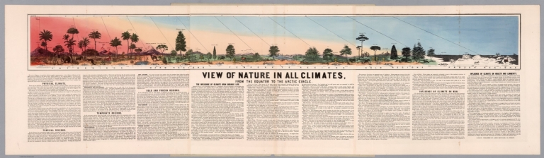
Author
[Reynolds, James, 1817-1876, Emslie, John, 1813-1875]
Full Title
View of nature in all climates, from the equator to the arctic circle. Feby. 24, 1859. London : Published by James Reynolds, 174, Strand.
List No
14340.002
Note
View of nature in different climates around the globe. Shows the equinoctial angles of the sun's rays and the effects of light and heat on plant and animal life in all regions from the equator to the Arctic circle. Features the distribution of organic life in a horizontal orientation, with plants - such as oak and pine trees - and animals - lions and polar bears - that live in different climates, as well as landmarks, such as the Alps. With descriptive text beneath view, including sections: Physical climate -- Tropical regions -- Temperate regions -- Cold and frozen regions -- The influence of climate upon organic life -- Influence of climate on man -- Influence of climate on health and longevity. Colored engraving by John Emslie. View is 17 x 161 cm, on fold-out sheet 51 x 175 cm.
Author
Johnson, A.J.
Full Title
Johnson's Map of the Vicinity of Richmond, and Peninsular Campaign in Virginia. Showing also the Interesting Localities along the James, Chickahominy, and York Rivers. Compiled from the Official Maps of the War Department. By Johnson and Ward.
List No
0352.025
Note
In full color by county. Shows roads, railroads, settlements, and swamps. Prime meridians are Greenwich and Washington D.C. Relief shown by hachures. Depth shown by soundings.
Author
Johnson, A.J.
Full Title
Johnson's Map of the Vicinity of Richmond, and Peninsular Campaign in Virginia (American Civil War) ... By Johnson and Ward.
List No
0535.024
Note
In full color by county. Shows roads, railroads, settlements, swamps and water depth soundings. Meridians Greenwich and Washington D.C.
Author
Johnson, A.J.
Full Title
Johnson's Georgetown and the City of Washington, the Capital of the United States of America. By Johnson and Ward.
List No
0535.025
Note
In full color by county. Includes vignettes of the Smithsonian Institution, Washington Monument, and the Capitol.
Author
Andriveau-Goujon, Eugene
Full Title
Europe. Paris - 1862. E. Andriveau-Goujon, Rue du Bac. 21. Paris. Impie. de Chardon. (to accompany) Atlas classique et universel de geographie ancienne et moderne ... Nouvelle edition. 1863.
List No
13421.023
Note
Hand color map. Shows political boundaries and major cities. Relief shown by hachures.
Author
Andriveau-Goujon, Eugene
Full Title
Etats Scandinaves. Paris - E. Andriveau-Goujon, Editeur - 1862. Rue du Bac. 21. Grave le Trait par Smith ; la Topographie par Gerin ; les Ecritures par P. Rousset. Les Eaux par Mme Fontaine - Paris Impie de Chardon Jeune. (to accompany) Atlas classique et universel de geographie ancienne et moderne ... Nouvelle edition. 1863.
List No
13421.025
Note
Hand color map, with inset of continuation map. Shows political and administrative boundaries, capitals, cities, towns, rivers, canals, rods and railroads. Relief shown by hachures. Includes color coded reference, legend and explanation.
Author
Andriveau-Goujon, Eugene
Full Title
Isles Britanniques. Paris - 1862. E. Andriveau-Goujon, Editeur. Rue du Bac. 21. Grave le Trait par Smith ; les montagnes par Gerin ; les Ecritures par P. Rousset. Les Eaux par Mme Fontaine - Paris Impie de Louis Antoine. (to accompany) Atlas classique et universel de geographie ancienne et moderne ... Nouvelle edition. 1863.
List No
13421.026
Note
Hand color map, with inset map: inset of Shetland Isles. Shows political and administrative boundaries. Relief shown by hachures. Includes legend, table and explanation.
Author
Andriveau-Goujon, Eugene
Full Title
Belgique, Hollande & bords du Rhin. Paris - 1862. E. Andriveau-Goujon, Editeur. Rue du Bac. 21. Gravee par P. Rousset, Th. Gobert et Fontaine. Dressee et dessinee par A. Vuillemin. Imp. Alfred Chardon Jne. (to accompany) Atlas classique et universel de geograparphie ancienne et moderne ... Nouvelle edition. 1863.
List No
13421.027
Note
Hand color map. Shows political and administrative boundaries. Relief shown by hachures. Includes legend, table and explanation.
Author
Andriveau-Goujon, Eugene
Full Title
Suisse : d'apres L'Etat-Major Federal et les nouvelles Cartes Cantonales. Paris - 1862. E. Andriveau-Goujon. Rue du Bac. 21. Paris, Impie. de Louis Antoine. Grave le trait par Smith; la topographie par Gerin; les Ecritures par P. Rousset. Les Eaux par Fontaine. (to accompany) Atlas classique et universel de geograparphie ancienne et moderne ... Nouvelle edition. 1863.
List No
13421.035
Note
Hand color folded map. Shows administrative boundaries. Relief shown by hachures. Includes legend.
Author
Andriveau-Goujon, Eugene
Full Title
Italie. Paris - 1862. E. Andriveau-Goujon. Rue du Bac. 21. Paris, Impie. de Louis Antoine. Grave le trait par Smith; les montagne par Gerin; les Ecritures par P. Rousset. Les Eaux par Mme. Fontaine. (to accompany) Atlas classique et universel de geograparphie ancienne et moderne ... Nouvelle edition. 1863.
List No
13421.036
Note
Hand color folded map. Shows administrative boundaries, roads and railroads. Relief shown by hachures.
Author
Andriveau-Goujon, Eugene
Full Title
Allemagne ou Europe Centrale. Paris - 1862. E. Andriveau-Goujon. Rue du Bac. 21. Le chemins de fer par Alfred Potiquet. Dressee et dessinee par A. Vuillemin. Le chemins de fer par Alfred Potiquet. Grave par Smith; Gerin; Dalmont. Imp. Louis Antoine. (to accompany) Atlas classique et universel de geograparphie ancienne et moderne ... Nouvelle edition. 1863.
List No
13421.038
Note
Hand color map. Shows administrative boundaries, roads and railroads. Relief shown by hachures. Includes legend and table of abbreviations.
Author
Andriveau-Goujon, Eugene
Full Title
Asie Meridionale : comprenant la presqu'île de l'Inde, la Perse, l'Afghanistan et le Beloutchistan. Paris - 1862. E. Andriveau-Goujon. Rue du Bac. 21. Dressee par A. Vuillemin. Grave le trait et les montagnes par Gerin; les Ecritures par P. Rousset. Les Eaux par Mme. Fontaine. Imp. A. Chardon. (to accompany) Atlas classique et universel de geograparphie ancienne et moderne ... Nouvelle edition. 1863.
List No
13421.048
Note
Hand color map. Shows political boundaries and possessions of European in South Asia. Relief shown by hachures. Includes explanation.
Author
Andriveau-Goujon, Eugene
Full Title
Asie Orientale comprenant L'Empire Chinois et le Japon, les Etats de L'Indo-Chine et le Grand Archipel d'Asie. (to accompany) Atlas classique et universel de geograparphie ancienne et moderne ... Nouvelle edition. 1863.
List No
13421.049
Note
1 hand color map on 2 sheets. Northern part of East Asia. Title from sheet 39. Shows political boundaries. Relief shown by hachures.
Author
Andriveau-Goujon, Eugene
Full Title
Asie Orientale comprenant L'Empire Chinois et le Japon, les Etats de L'Indo-Chine et le Grand Archipel d'Asie. (to accompany) Atlas classique et universel de geograparphie ancienne et moderne ... Nouvelle edition. 1863.
List No
13421.050
Note
1 hand color map on 2 sheets. Southern part of East Asia. Title from sheet 39. Shows political boundaries. Relief shown by hachures.
Author
Andriveau-Goujon, Eugene
Full Title
Indes Neerlandaises ou Grand Archipel D'Asie. Paris - 1862. E. Andriveau-Goujon. Rue du Bac. 21. Grave chez Erhard. Impie. Lemercier. (to accompany) Atlas classique et universel de geograparphie ancienne et moderne ... Nouvelle edition. 1863.
List No
13421.052
Note
Hand color map of the Dutch Indies, the Philippines, Southeast Asia, Spice Islands and the Northern Part of Australia. Relief shown by hachures. Includes table and color coded reference to European colonies.
Author
Andriveau-Goujon, Eugene
Full Title
Oceanie. Paris - 1862. E. Andriveau-Goujon. Rue du Bac. 21. Impie. de Louis Antoine. Gravee par Melle. Flauhaut et Smith ; les ecritures par P. Rousset ; les eaux par Mme. Fontaine. (to accompany) Atlas classique et universel de geograparphie ancienne et moderne ... Nouvelle edition. 1863.
List No
13421.053
Note
Hand color map of Oceania. Relief shown by hachures. Includes color coded reference to European colonies.
Author
Andriveau-Goujon, Eugene
Full Title
Algerie, d'apres les cartes de l'Etat-major et les documents du Ministere de la Guerre. E. Andriveau-Goujon, Editeur. Paris, Rue du Bac. 21.1862. Paris, Impie. de Louis Antoine. Gravee par Ms. Gerin, Dalmont, Smith et Fontaine. (to accompany) Atlas classique et universel de geograparphie ancienne et moderne ... Nouvelle edition. 1863.
List No
13421.055
Note
1 hand color map on 2 sheets. Western part. Inset: Carte d'ensemble des rapports entre la France l'Algerie, la Senegambie et le Nord de l'Afrique. Shows boundaries, major cities, roads, railways, forts, etc. Relief shown by hachures. Includes color coded reference to European colonies in North Africa, legend and text.
Author
Andriveau-Goujon, Eugene
Full Title
Algerie, d'apres les cartes de l'Etat-major et les documents du Ministere de la Guerre. E. Andriveau-Goujon, Editeur. Paris, Rue du Bac. 21.1862. Paris, Impie. de Louis Antoine. Gravee par Ms. Gerin, Dalmont, Smith et Fontaine. (to accompany) Atlas classique et universel de geograparphie ancienne et moderne ... Nouvelle edition. 1863.
List No
13421.056
Note
1 hand color map on 2 sheets. Eastern part. Inset: Carte d'ensemble des rapports entre la France l'Algerie, la Senegambie et le Nord de l'Afrique. Shows boundaries, major cities, roads, railways, forts, etc. Relief shown by hachures. Includes color coded reference to European colonies in North Africa, legend and text.
Author
Andriveau-Goujon, Eugene
Full Title
Carte Generale des Etats - Unis et du Mexique : Comprenant L'Amerique Centrale Et Les Antilles. E. Andriveau-Goujon, Editeur. Paris, Rue Du Bac, 21. 1862. (to accompany) Atlas classique et universel de geograparphie ancienne et moderne ... Nouvelle edition. 1863.
List No
13421.060
Note
1 hand color map on 2 sheets, Western part. Includes 4 Insets. Title from plate 48, Eastern part. Shows political and administrative boundaries, roads, railways, rivers and mountains. Relief shown by hachures. Prime meridian: Paris. Includes color coded reference to European possessions and legend.
Author
Andriveau-Goujon, Eugene
Full Title
Carte Generale des Etats - Unis et du Mexique : Comprenant L'Amerique Centrale Et Les Antilles. E. Andriveau-Goujon, Editeur. Paris, Rue Du Bac, 21. 1862. (to accompany) Atlas classique et universel de geograparphie ancienne et moderne ... Nouvelle edition. 1863.
List No
13421.061
Note
1 hand color map on 2 sheets, Eastern part. Includes 4 Insets. Title from plate 48, Eastern part. Shows political and administrative boundaries, roads, railways, rivers and mountains. Relief shown by hachures. Prime meridian: Paris. Includes color coded reference to European possessions and legend.
Author
Andriveau-Goujon, Eugene
Full Title
Amerique du Sud. Paris - 1862. E. Andriveau-Goujon, Editeur. Rue Du Bac, 21. Paris, Impie. de Louis Antoine. Gravee par Smith et Gerin ; les ecritures par P. Rousset ; les eaux par Mme. Fontaine. (to accompany) Atlas classique et universel de geograparphie ancienne et moderne ... Nouvelle edition. 1863.
List No
13421.063
Note
Hand color map. Insets: Iles Gallapagos -- Terres Australes. Shows political boundaries, roads, rivers and mountains. Relief shown by hachures.
Author
Geographisches Institut (Weimar, Germany)
Full Title
Frankreich. Bearbeitet von C. Graf. Terrain gez. v. A. Muller, gest. v. C. Ohmann, 1862. Situation u. schrift v. Dellinger u. E. Biedermann. Weimar: Geographisches Institut. (to accompany) Hand - Atlas Der Erde Und Des Himmels.
List No
2595.038
Note
Outline hand color map. Color coded by region. Shows cities and towns, roads, railroads, rivers, etc. Includes legend, abbreviations, and list of Departments. Relief shown by hachures. Prime meridians are Ferro and Paris.
Author
Geographisches Institut (Weimar, Germany)
Full Title
Frankreich : Mit Piedmont, Schweiz, Baden, Wortemberg, Rhein-Provinz, Hessen und Belgien. Revidirt, 1862. Weimar: Geographisches Institut. (to accompany) Hand - Atlas Der Erde Und Des Himmels.
List No
2595.039
Note
Outline hand color map in 4 plates, 111x118.5, each 55x59 or smaller. Title from lower right plate. Insets on sheet 3. Color coded by region. Shows cities and towns, roads, railroads, rivers, etc. Includes legend. Relief shown by hachures. Prime meridians are Ferro and Paris.
Author
Geographisches Institut (Weimar, Germany)
Full Title
Frankreich : Mit Piedmont, Schweiz, Baden, Wortemberg, Rhein-Provinz, Hessen und Belgien. Revidirt, 1862. Weimar: Geographisches Institut. (to accompany) Hand - Atlas Der Erde Und Des Himmels.
List No
2595.040
Note
Outline hand color map in 4 plates, 111x118.5, each 55x59 or smaller. Title from lower right plate. Insets on sheet 3. Color coded by region. Shows cities and towns, roads, railroads, rivers, etc. Includes legend. Relief shown by hachures. Prime meridians are Ferro and Paris.
Author
Geographisches Institut (Weimar, Germany)
Full Title
Frankreich : Mit Piedmont, Schweiz, Baden, Wortemberg, Rhein-Provinz, Hessen und Belgien. Revidirt, 1862. Weimar: Geographisches Institut. (insets) Frankreich. (with) Umgegend von Paris. (to accompany) Hand - Atlas Der Erde Und Des Himmels.
List No
2595.041
Note
Outline hand color map in 4 plates, 111x118.5, each 55x59 or smaller. Title from lower right plate. Insets on sheet 3. Color coded by region. Shows cities and towns, roads, railroads, rivers, etc. Includes legend. Relief shown by hachures. Prime meridians are Ferro and Paris.
Author
Geographisches Institut (Weimar, Germany)
Full Title
Frankreich : Mit Piedmont, Schweiz, Baden, Wortemberg, Rhein-Provinz, Hessen und Belgien. Revidirt, 1862. Weimar: Geographisches Institut. (to accompany) Hand - Atlas Der Erde Und Des Himmels.
List No
2595.042
Note
Outline hand color map in 4 plates, 111x118.5, each 55x59 or smaller. Title from lower right plate. Insets on sheet 3. Color coded by region. Shows cities and towns, roads, railroads, rivers, etc. Includes legend. Relief shown by hachures. Prime meridians are Ferro and Paris.
Author
Geographisches Institut (Weimar, Germany)
Full Title
(Composite of ) Frankreich : Mit Piedmont, Schweiz, Baden, Wortemberg, Rhein-Provinz, Hessen und Belgien. Revidirt, 1862. Weimar: Geographisches Institut. (to accompany) Hand - Atlas Der Erde Und Des Himmels.
List No
2595.043
Note
Composite map of all four sheets. Outline hand color map in 4 plates, 111x118.5, each 55x59 or smaller. Title from lower right plate. Insets on sheet 3. Color coded by region. Shows cities and towns, roads, railroads, rivers, etc. Includes legend. Relief shown by hachures. Prime meridians are Ferro and Paris.
Author
Colton, G.W.
Full Title
Colton's Iowa.
List No
3800.105
Author
Johnson, Alvin Jewett, 1827-1884.
Full Title
Johnson's map of the vicinity of Richmond, and Peninsular Campaign in Virginia. Showing also the interesting localities along the James, Chickahominiy and York Rivers. Compiled from the official maps of the War Department. Published by Alvin J. Johnson & Son, New York. Entered ... 1862, by A.J. Johnson ... New York. (to accompany) Johnson's New Illustrated Family Atlas Of The World ... MDCCCLXXX (1880).
List No
4830.079
Note
Engraved hand colored in outline map on 2 sheets. Shows towns, roads, railroads, rivers, lakes, bays, islands, and swamps. The Peninsula Campaign (also known as the Peninsular Campaign) of the American Civil War was a major Union operation launched in southeastern Virginia from March through July 1862. Relief shown by hachures. Depth shown by soundings and isolines.
Author
[Dufour, Auguste-Henri (1798-1865), Dyonnet, Charles]
Full Title
Empire Romain : Dresse par A.H. Dufour. 1862. Gravee par Ch. Dyonnet. Paris, Armand Le Chevalier, Rue Richelieu, 60. Impe. par Louis Antonie, r. de Cluny 1, Paris. (to accompany) Atlas Universel, Physique, Historique Et Politique De Geographie Ancienne Et Moderne. (on upper margin) Geographie ancienne Pl. 4.
List No
5020.007
Note
Outline hand color map of the Roman Empire. Regions are distinguished by muted pastel colors. Shows the extent of the empire, rivers, lakes, mountains, provinces, and important cities. Relief shown by hachures. Prime meridian is Paris.
Author
[Dufour, Auguste-Henri (1798-1865), Dyonnet, Charles]
Full Title
Asie : Dresse par A.H. Dufour. Gravee par Ch. Dyonnet 1862. Armand Le Chevalier, 60 Rue Richelieu, Paris. Impe. par Louis Antonie, r. de Cluny 1, Paris. (to accompany) Atlas Universel, Physique, Historique Et Politique De Geographie Ancienne Et Moderne. Pl. 32. (on upper margin) Geographie moderne. Pl. 23.
List No
5020.036
Note
Outline hand color map. Shows political divisions, cities and towns, major roads, rivers, etc. Relief shown by hachures. Prime meridian is Paris. Includes notes.
Author
Garnier, F. A., 1803-1863
Full Title
(Covers to) Atlas spheroidal et universel de geographie dresse a l'aide des documents officiels, recemment publies en France et a l'etranger par M.F.A. Garnier, Membre de la Societe de Geographie, etc. Paris, Veuve Jules Renouard, Libraire, Editeur de A. Balbi, Abrege de Geographie; A. Guibert, Dictionnaire de Geographie; Dufour et Jomard, Le Globe, etc. Rue de Tournon, 6, Faubourg Saint-Germain. MDCCCLXII.
List No
5023A
Note
This atlas is exceptional for its "spheroidal" maps of the globe, showing the various continents and poles, shaded to give the effect of a sphere floating in space. The remaining maps are also very well executed and colored, mostly by hand, a few in colored litho. In recent years, this atlas has become rare in the trade. This is the only atlas that Garnier produced, according to Phillips. Tooley lists an 1860 edition. Covers are quarter leather marbled paper covered boards with a paper label; the burgundy leather spine is embossed with "F.A. Garnier. Atlas Universel et Spheroidal de Geographie" in gilt. On verso of half-title: Paris -- Imprimerie de P.-A. Bourdier et Cie., Rue Mazarine, 30.
Author
Garnier, F. A., 1803-1863
Full Title
(Half Title Page to) Atlas spheroidal et universel de geographie dresse a l'aide des documents officiels, recemment publies en France et a l'etranger par M.F.A. Garnier, Membre de la Societe de Geographie, etc. Paris, Veuve Jules Renouard, Libraire, Editeur de A. Balbi, Abrege de Geographie; A. Guibert, Dictionnaire de Geographie; Dufour et Jomard, Le Globe, etc. Rue de Tournon, 6, Faubourg Saint-Germain. MDCCCLXII.
List No
5023B
Note
This atlas is exceptional for its "spheroidal" maps of the globe, showing the various continents and poles, shaded to give the effect of a sphere floating in space. The remaining maps are also very well executed and colored, mostly by hand, a few in colored litho. In recent years, this atlas has become rare in the trade. This is the only atlas that Garnier produced, according to Phillips. Tooley lists an 1860 edition. Covers are quarter leather marbled paper covered boards with a paper label; the burgundy leather spine is embossed with "F.A. Garnier. Atlas Universel et Spheroidal de Geographie" in gilt. On verso of half-title: Paris -- Imprimerie de P.-A. Bourdier et Cie., Rue Mazarine, 30.
Author
Garnier, F. A., 1803-1863
Full Title
(Title Page to) Atlas spheroidal et universel de geographie dresse a l'aide des documents officiels, recemment publies en France et a l'etranger par M.F.A. Garnier, Membre de la Societe de Geographie, etc. Paris, Veuve Jules Renouard, Libraire, Editeur de A. Balbi, Abrege de Geographie; A. Guibert, Dictionnaire de Geographie; Dufour et Jomard, Le Globe, etc. Rue de Tournon, 6, Faubourg Saint-Germain. MDCCCLXII.
List No
5023C
Note
This atlas is exceptional for its "spheroidal" maps of the globe, showing the various continents and poles, shaded to give the effect of a sphere floating in space. The remaining maps are also very well executed and colored, mostly by hand, a few in colored litho. In recent years, this atlas has become rare in the trade. This is the only atlas that Garnier produced, according to Phillips. Tooley lists an 1860 edition. Covers are quarter leather marbled paper covered boards with a paper label; the burgundy leather spine is embossed with "F.A. Garnier. Atlas Universel et Spheroidal de Geographie" in gilt. On verso of half-title: Paris -- Imprimerie de P.-A. Bourdier et Cie., Rue Mazarine, 30.
Author
Garnier, F. A., 1803-1863
Full Title
(Contents to) Atlas spheroidal et universel de geographie dresse a l'aide des documents officiels, recemment publies en France et a l'etranger par M.F.A. Garnier, Membre de la Societe de Geographie, etc. Paris, Veuve Jules Renouard, Libraire, Editeur de A. Balbi, Abrege de Geographie; A. Guibert, Dictionnaire de Geographie; Dufour et Jomard, Le Globe, etc. Rue de Tournon, 6, Faubourg Saint-Germain. MDCCCLXII.
List No
5023D
Note
This atlas is exceptional for its "spheroidal" maps of the globe, showing the various continents and poles, shaded to give the effect of a sphere floating in space. The remaining maps are also very well executed and colored, mostly by hand, a few in colored litho. In recent years, this atlas has become rare in the trade. This is the only atlas that Garnier produced, according to Phillips. Tooley lists an 1860 edition. Covers are quarter leather marbled paper covered boards with a paper label; the burgundy leather spine is embossed with "F.A. Garnier. Atlas Universel et Spheroidal de Geographie" in gilt. On verso of half-title: Paris -- Imprimerie de P.-A. Bourdier et Cie., Rue Mazarine, 30.
|