|
Author
[Arrowsmith, John, 1790-1873, Fitzroy, Robert, 1805-1865]
Full Title
The registration districts of the metropolis 1843. John Arrowsmith, 10 Soho Square.
List No
14506.132
Note
Map representing London. Shows districts, roads, buildings, parks, and drainage. Includes a legend and informational text. Map is 53 x 67 cm, on double sheet 56 x 68 cm.
Author
[Morse, Charles W., Colby, Charles A.]
Full Title
Nova-Scotia, New Brunswick &c.
List No
0623.010
Author
[Morse, Charles W., Colby, Charles A.]
Full Title
South Carolina.
List No
0623.024
Author
[Murchison, Roderick Impey, Sir, 1792-1871, Society for the Diffusion of Useful Knowledge (Great Britain)]
Full Title
Geological map of England and Wales. Published under the superintendence of the Society for the Diffusion of Useful Knowledge. 1843. Arranged by Roderick Impey Murchison ... S.P. Woodward del. Col(oure)d. by T. Malby. J. & C. Walker sculpt. Published by Chapman & Hall 186 Strand Decr. 15th. 1843. (1844)
List No
0890.012
Note
Engraved map. Geologic units hand col. Also shows railroads, canals, navigable rivers and dip of strata.
Author
Society for the Diffusion of Useful Knowledge (Great Britain)
Full Title
The Netherlands, de Nederlanden, and Belgium, La Belgique. Published for the Society for the Diffusion of Useful Knowledge, by Chapman & Hall, 186 Strand, October 1, 1843. J & C. Walker sculpt. (1844)
List No
0890.029
Note
Engraved map. Provincial boundaries hand col. Shows railroads, populations of large towns, etc. Includes table of provinces with area, population and population per square mile.
Author
Society for the Diffusion of Useful Knowledge (Great Britain)
Full Title
The Turkish Empire in Europe and Asia with the Kingdom of Greece. Engraved by J. & C. Walker. Published by the Society for the Diffusion of Useful Knowledge, 42 Bedford Sqre. Octr. 15th. 1843. (London: Chapman & Hall, 1844)
List No
0890.071
Note
Engraved map. Relief shown by hachures. Country borders and lakes hand col.
Author
[Smith, William, Sir, 1813-1893, Society for the Diffusion of Useful Knowledge (Great Britain)]
Full Title
Grecian Archipelago, ancient, by William Smith L.L.D. Published under the superintendence of the Society for the Diffusion of Useful Knowledge. Engraved by J. & C. Walker. Published by Chapman & Hall 186 Strand April 1st. 1843 (1844)
List No
0890.072
Note
Engraved map. Relief shown by hachures. Coastal waters hand col.
Author
Society for the Diffusion of Useful Knowledge (Great Britain)
Full Title
Ancient Syria. By W. Hughes, Prof. Geogr(aph)y, Coll. for Civ. Engrs. (with) Part of Arabia including Mount Sinai and the wanderings of the Israelites on the same scale. Published under the superintendence of the Society for the Diffusion of Useful Knowledge. (Engraved by) W. Hughes, 1843. London, published March 15th. 1843 by Chapman & Hall, 186, Strand (1844)
List No
0890.082
Note
Engraved map. Relief shown by hachures. Country borders hand col.
Author
Society for the Diffusion of Useful Knowledge (Great Britain)
Full Title
Syria. By W. Hughes, Prof. Geogr(aph)y, Coll. for Civ. Engrs. Published under the superintendence of the Society for the Diffusion of Useful Knowledge. (Engraved by) W. Hughes, 1842. London, published Jany. 10th. 1843 by Chapman & Hall, 186, Strand (1844)
List No
0890.083
Note
Engraved map. Relief shown by hachures. Country borders hand col. Includes inset: Continuation from the Dead Sea to Mount Sinai on the same scale.
Author
Society for the Diffusion of Useful Knowledge (Great Britain)
Full Title
Palestine in the time of Our Saviour. By W. Hughes, Prof. Geogr(aph)y, Coll. for Civ. Engrs. (with) Plan showing the probable extent of ancient Jerusalem. Published under the superintendence of the Society for the Diffusion of Useful Knowledge. (Engraved by) W. Hughes, 1842. London, published Jany. 10th. 1843 by Chapman & Hall, 186, Strand (1844)
List No
0890.084
Note
Engraved map. Relief shown by hachures. Country borders hand col. Scale of inset map (ca. 1:31,000)
Author
Society for the Diffusion of Useful Knowledge (Great Britain)
Full Title
Palestine with the Hauran and the adjacent districts By W. Hughes, Prof. Geogr(aph)y, Coll. for Civ. Engrs. (with) Modern plan of Jerusalem. Published under the superintendence of the Society for the Diffusion of Useful Knowledge. (Engraved by) W. Hughes, 1843. London, published April 15th. 1843 by Chapman & Hall, 186, Strand (1844)
List No
0890.085
Note
Engraved map. Relief shown by hachures. Country borders hand col. Scale of inset map (ca. 1:31,000). Sources: Robinson, Burckhardt, Jacotin and others.
Author
Society for the Diffusion of Useful Knowledge (Great Britain)
Full Title
Arabia with Egypt, Nubia and Abyssinia. J. & C. Walker sculpt. Published by the Society for the Diffusion of Useful Knowledge, 42 Bedford Sqre. Octr. 15th. 1843. (London: Chapman & Hall, 1844)
List No
0890.086
Note
Engraved map. Relief shown by hachures. Country borders hand col.
Author
Society for the Diffusion of Useful Knowledge (Great Britain)
Full Title
China. Engraved by J. & C. Walker. Published for the Society for the Diffusion of Useful Knowledge by Chapman & Hall, 186 Strand, October 1, 1843. (1844)
List No
0890.106
Note
Engraved map. Relief shown by hachures. Provincial boundaries hand col. "The interior chiefly from Du Halde and the Jesuits 1710 to 1718 and the sea coast from modern authorities."
Author
Society for the Diffusion of Useful Knowledge (Great Britain)
Full Title
North America. Published under the superintendence of the Society for the Diffusion of Useful Knowledge. Engraved by J. & C. Walker. Published by Chapman & Hall, 186 Strand, Feby. 25th. 1843. (1844)
List No
0890.125
Note
Engraved map. Relief shown by hachures. Country boundaries hand col.
Author
Society for the Diffusion of Useful Knowledge (Great Britain)
Full Title
London. 1843. Drawn & engraved from authentic documents & personal observation by B.R. Davies, 16 George Street, Euston Square. London, published Nov. 1, 1843 under the superintendence of the Society for the Diffusion of Useful Knowledge, by Chapman & Hall, 186 Strand (1844)
List No
0890.184
Note
Engraved map. Hand col. David Rumsey Collection copy of atlas also includes 1836 ed.
Author
[Picquet, Ch., Brue]
Full Title
Carte Generale du Perou du Haut-Perou, du Chili et de la Plata.
List No
12050.067
Author
[Rodini, Giuseppe, Marzolla, Benedetto]
Full Title
Egitto ed Arabia Petrea.
List No
12502.020
Note
This map by Marzolla may have been added to the atlas.
Author
Geirnaert, P.F.
Full Title
Carte de l'eveche de Liege, dediee e Monseigneur Corn. Rich. Ant. van Bommel. ... Par P. F. Geirnaert. Etablishment Geographique de Bruxlles, fonde par Ph. Vandermaelen. (to accompany) Atlas geographique ... 3eme partie, Geographie moderne actuelle ... 1823.
List No
13006.030
Note
Outline hand colored folded map of bishopric of Liege. by P. F. Geirnaert. Shows districts, major cities, towns, villages, rivers, canals, creeks, roads, etc. Includes key to symbols. Date estimated.
Author
Arrowsmith, John, 1790-1873
Full Title
The Sandwich Islands, from various official documents. Compiled by John Arrowsmith. London. Pubd. Novr. 7th 1843 by John Arrowsmith, 10 Soho Square.
List No
14506.090
Note
Map representing current-day Hawaii. Shows political boundaries, cities, roads, topography, drainage, coastlines, islands, and water depths. Relief shown with hachures. Includes a legend, latitudinal and longitudinal lines, as well as a bar scale given in English miles. With five inset maps: Plan of Honolulu or Honoruru Harbour. Surveyed by Lieutt. C.R. Malden R.N. 1825. -- Plan of Kairua Bay. -- Walakea or Byron Bay, surveyed by Lieutt. C.R. Malden R.N. 1825. -- Hanalai Bay surveyed by Captn. Belcher R.N. 1838. -- Pearl Lochs on the south coast of Woahoo. Hand-colored engraving. Map is 22 x 32 cm, on sheet 56 x 38 cm.
Author
[Black, Adam & Charles, Hall, Sidney, Hughes, William]
Full Title
The Countries embraced within the Travels of St. Paul. By W. Hughes 1843. Lower Egypt with the Peninsula of Mt. Sinai and the Journeys of the Israelites. Edinburgh, Published by A. &. C. Black. W. Hughes
List No
2305.072
Note
Two maps on one sheet. Travels of St. Paul at a scale of 1:8,400,000. Lower Egypt at a scale of 1:2,450,000. Engraved. Relief shown with hachures. Regions tinted.
Author
Berghaus, Heinrich
Full Title
Vermischtes zur Hydrographie: Schwankungen des Ostsee Standes, Strom Neigungen, &c. &c. 2te Abtheilung: Hydrographie, No. 10. Potsdam, gez. u. gest. in der geogr. Kunstschule. Gotha, bei Justus Perthes. 1843.
List No
2515.021
Note
Numerous charts showing miscellaneous hydrographic information about the rivers of Europe.
Author
Berghaus, Heinrich
Full Title
Europa in Geologischer Beziehung nach den Hauptmassen der Gebirgs-Formationen. 3te Abtheilung: Geologie, No. 4. Gotha, bei J. Perthes. 1843.
List No
2515.031
Note
A geologic map of Europe showing active volcanoes, and the oldest and newest mountain ranges on the continent. In full color.
Author
Berghaus, Heinrich
Full Title
Karte von Sud-Amerika zur Ubersicht der Unebenheiten des Bodens. 3te Abtheilung: Geologie, No. 5. Potsdam, gez. u. gest. in der geogr. Kunstschule. Gotha, bei Justus Perthes, 1843.
List No
2515.032
Note
Map showing the topography of South America. Includes three inset maps: The southern tip of South America, the mountain region of Quito, Ecuador, and part of Bolivia. In outline color.
Author
Berghaus, Heinrich
Full Title
Geologische Karte von Deutschland und den anlieg. Landern nach des Bergmeister's H. Credner Zusamenstellung. 1843. 3te Abtheilung: Geologie, No. 12. Gotha, bei J. Perthes.
List No
2515.039
Note
A full color geologic map of Germany accompanied by two keys.
Author
Berghaus, Heinrich
Full Title
Spezial-Karte vom Riesen-Gebirge. 3te Abtheilung: Geologie, No. 13. Gezeichnet u. gestochen in der geogr. Kunstschule zu Potsdam. Gotha, J. Perthes, 1843.
List No
2515.040
Note
Geologic map of the Reisengebirge (or Krkonose, Karkonosze or Giant Mountains) in the Czech Republic and Poland.
Author
Marzolla, Benedetto
Full Title
Carta generale del mondo conosciuto dagli antichi. Napoli 1843. Reale Litografia Militare, Benedetto Marzolla, impiegato nel Rle. Officio Topografico esgui col pennello su pietra.
List No
4714.002
Note
Lithographed map. Country borders hand col. Relief shown by hachures. Prime meridian: Paris.
Author
Marzolla, Benedetto
Full Title
Descrizione del globo in due emisferi nella quale sono indicate tutte le scoperte finora fatte, compilata, ed eseguita col pennello su pietra da Benedetto Marzolla, 1843. Napoli, Reale Litografia Militare.
List No
4714.008
Note
Lithographed map. Borders hand col. Relief shown by hachures. Includes tables of geographical data. Prime meridian: Paris.
Author
Marzolla, Benedetto
Full Title
Carta generale di Affrica. Benedetto Marzolla esegui col pennello su pietra, Napoli 1843.
List No
4714.031
Note
Lithographed map. Borders hand col. Relief shown by hachures. Includes notes and statistical tables. Prime meridian: Paris.
Author
Marzolla, Benedetto
Full Title
Egitto ed Arabia Petrea. Benedetto Marzolla esegui, 1843.
List No
4714.035
Note
Lithographed map. Hand col. Relief shown by hachures. Includes notes and statistical tables. Prime meridian: Paris.
Author
Delamarche, Felix.
Full Title
L'Empire Romai et les Barbares du Nord au IVeme Siecle ...1843.
List No
4758.020
Author
Delamarche, Felix.
Full Title
Carte de L'Empire Carlovingien et des Empires Arabes ... 1843. (inset) Partage de L'Empire Carlovingies.
List No
4758.022
Author
Delamarche, Felix.
Full Title
Carte de la Suisse ou Helvetie ... 1843.
List No
4758.030
Author
Delamarche, Felix.
Full Title
Carte de L'Afrique ... 1843. (inset) Carte de L'Egypte, de la Nubie de L'Abissinie, du Kordofan et du Barfour.
List No
4758.038
Author
Radefeld, Carl Christian Franz, 1788-1874
Full Title
Neueste Karte von Europa entworfen und gezeichnet von Hptm. Radefeld 1843. Stahlstich, Direction v. Kleinknecht, aus der Schweinfurter Geographischen Graviranstalt des Bibliographischen Instituts zu Hildburghausen, Amsterdam, Paris u. Philadelphia, (1860)
List No
4807.010
Note
Engraved map. Countries outlined in hand col. Relief shown by hachures. Prime meridian: Ferro. "Meyers Handatlas No. 3."
Author
Meyer, Joseph, 1796-1856
Full Title
Neueste Karte von Spanien und Portugal 1843. (with) Lissabon. (with) Madrid. Aus der Geographischen Graviranstalt des Bibliographischen Instituts zu Hildburghausen, Amsterdam, Paris u. Philadelphia, (1860)
List No
4807.012
Note
Engraved map. Provincial boundaries hand col. Relief shown by hachures. Scale of inset maps not given. Prime meridian: Ferro. "Meyer's Handatlas No. 5."
Author
Radefeld, Carl Christian Franz, 1788-1874
Full Title
Neueste Karte von Salzburg. Entw. u. gez. v. Hauptm. Radefeld. 1843. Stahlstich, Direction v. Kleinknecht, aus der Schweinfurter Geographischen Graviranstalt des Bibliographischen Instituts zu Hildburghausen, Amsterdam, Paris und Philadelphia, (1860)
List No
4807.067
Note
Engraved map. Administrative boundaries hand col. Relief shown by hachures and spot heights. "Meyer's Hand-Atlas No. 6." Prime meridians: Paris and Ferro.
Author
Meyer, Joseph, 1796-1856
Full Title
Neueste Karte von Siebenburgen. Nach den besten Quellen entworf. u. gezeichn. von Hauptm. Radefeld. 1843. Verlag des Bibliographischen Instituts zu Hildburghausen, Amsterdam, Paris u. Philadelphia, (1860)
List No
4807.072
Note
Engraved map. Administrative boundaries hand col. Relief shown by hachures. "Meyer's Handatlas No. 7." Prime meridians: Ferro and Paris.
Author
Radefeld, Carl Christian Franz, 1788-1874
Full Title
Neueste Karte von America. Nach den bessten Quellen entworf u. gezeich. vom Hauptm. Radefeld. 1843. Stahlstich, Direction v. Kleinknecht aus der Schweinfurter Geographischen Graviranstalt des Bibliograph. Instituts zu Hildburghausen, Amsterdam, Paris und Philadelphia, (1860)
List No
4807.125
Note
Engraved map. Boundaries hand col. Relief shown by hachures. "Meyer's Handatlas No. 2." Prime meridian: Ferro.
Author
Radefeld, Carl Christian Franz, 1788-1874
Full Title
Neueste Karte von Centralamerica und West Indien, 1843. Entworf. u. gezeichn. v. Hauptm. Radefeld. (with) Der Isthmus von Panama. Loyds Aufnahme v. J. 1829. Stahlstich, Direction v. Kleinknecht, aus der Schweinfurter Geographischen Graviranstalt des Bibliographischen Instituts zu Hildburghausen, Amsterdam, Paris und Philadelphia, (1860)
List No
4807.168
Note
Engraved map. Boundaries hand col. Relief shown by hachures. "Meyer's Handatlas No. 4." Prime meridians: Paris and Ferro.
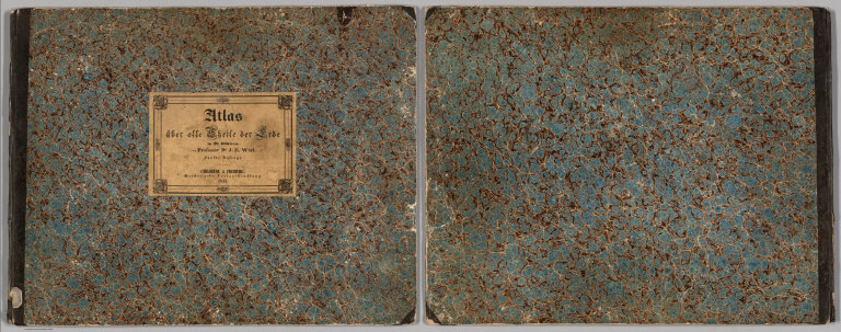
Author
Woerl, Joseph Edmund
Full Title
(Covers and Title to) Atlas ueber alle Theile der Erde in 28 Blaettern von Professor Dr. J.E. Wood fuenfte Auflage. Carlsruhe & Freiburg, Herder's che Verlagshandlung. 1843. (Atlas over all parts of the earth in 28 leaves of Professor Dr. J.E. Wood, fifth edition. Carlsruhe & Freiburg, Herder's Publishing House. In 1843.)
List No
7923.001
Note
Cover serves as a title page as well. Bluish marbled paper covers boards with pale yellow-brown label on front with title text in black.
Author
Woerl, Joseph Edmund
Full Title
Planigloben. (Earth in Hemispheres).
List No
7923.002
Author
Woerl, Joseph Edmund
Full Title
Europa I (Europe).
List No
7923.003
Author
Woerl, Joseph Edmund
Full Title
Europa (II) (Europe).
List No
7923.004
Author
Woerl, Joseph Edmund
Full Title
Die Iberische Halb-Insel: Spanien und Portugal. (Iberian Peninsula: Spain and Portugal).
List No
7923.005
Author
Woerl, Joseph Edmund
Full Title
Frankreich (France).
List No
7923.006
Author
Woerl, Joseph Edmund
Full Title
Grossbritannien (Great Britain).
List No
7923.007
Author
Woerl, Joseph Edmund
Full Title
Die Niederlande. Belgien und Luxemburg. (Netherlands. Belgium. Luxembourg).
List No
7923.008
Author
Woerl, Joseph Edmund
Full Title
Deutschland (I). (Germany).
List No
7923.009
Author
Woerl, Joseph Edmund
Full Title
Deutschland (II). (Germany).
List No
7923.029
Author
Woerl, Joseph Edmund
Full Title
Das Koen: Bayern, Koen: Wuerttemberg. Das Grossherzogth. Baden, Die Fuerstenthuemer Hohenzollern Sigmaringen und Hohenz. Hechingen. (Bavaria. Wuerttemberg.) (insets) Muechen. Stuttgart.
List No
7923.010
|