|
Author
[Placide de Sainte-Helene, 1648-1734, Du Val, Pierre, 1619-1683]
Full Title
(Portrait) R. P. Placidus A Sta. Helena Aug. Disc. Gal. Regis. Geographus. Aetis. 65. 1714. Elizabeth Gaultier Pinxit 1714. Langlois Sculp. (to accompany) Cartes de geographie par Le Rd. Pere Placide.
List No
13031.003
Note
Portrait of Father Placide de Saint Helena, Augustinian, engraved by Langlois after a painting by Elizabeth Gaultier of 1714.
Author
Willdey, George
Full Title
A New and Correct Map of the World : Projected upon the Plane of the Horizon laid down from the Newest Discoveries and most Exact Observations. By Charles C. Price. Sold by George Willdey. 1714.
List No
13539.004
Note
Double hemisphere map of the world, oriented with London at the center of Eastern Hemisphere and its antipode at the center of the Western Hemisphere. Published and sold by George Willdey. Across the top are allegorical images of the 4 continents as women and a decorative title cartouche, surrounded by a different group of 4 allegorical images of women. At the bottom are maps of the Sun (by Kircher) and the Moon (by Cassini), and a decorated dedication cartouche "To his Grace Charles Duke of Shrewsbury …”, along with vignettes depicting instruments and trade goods. California shown as a large island, with all regions to the north marked 'parts unknown.' The western half of 'New Holland' is shown, along with the known coastline of Tasmania. The map depicts the wind directions at sea, with arrows and hachuring, with various notes on wind directions.
Author
Willdey, George
Full Title
Asia : corrected according to ye latest discoveries & observations communicated by Royal Society, London & ye Royal Academy at Paris. By Eman. Bowen. 1714. Sold by George Willdey.
List No
13539.006
Note
Engraved hand color in outline map of Asia, with uncolored title cartouche. Insets: engraved views "The different habits of the people of several nations in these parts", " A lasy of Japan ..." Includes annotations and advertisement text.
Author
Willdey, George
Full Title
A Correct Map of Ireland : Divided into it's Provinces, Counties & Baronies, Shewing the Roads and the Distances of Places in Computed miles by Inspection where Barraques are Erected &c. C. Price, I. Senex & I. Maxwell. Sold by George Willdey 1714.
List No
13539.011
Note
Engraved hand color in outline map, with uncolored decorative cartouches. Includes dedication by C. Price. I. Senex & I. Maxwell. Includes annotations and coat of arms.
Author
[Placide de Sainte-Helene, 1648-1734, Du Val, Pierre, 1619-1683]
Full Title
(Title Page to) Cartes de geographie par Le Rd. Pere Placide, Augustin Dechausse Geographe ordinaire du Roy. N. Guerard inuenit et fecit.
List No
13031.002
Author
[Placide de Sainte-Helene, 1648-1734, Du Val, Pierre, 1619-1683]
Full Title
L'Ameriqve autrement le Novveav Monde et Indes Occidentales. Par P. Du -Val, d'Abbeville Geographe ordinaire du Roy. A Paris Chez Mad.lle Du-Val. Fille de l'Auteur ... 1684. (to accompany) Cartes de geographie par Le Rd. Pere Placide.
List No
13031.006
Note
Engraved detailed map of America, originally engraved in 1655. Covers North and South America, western coasts of Europe and Africa, and a landmass appears at the bottom right labeled Partie de la grande Terre Australe. Showing political divisions, many place names, colonial settlements, missions, Indian tribes, rivers and mountains. Depicts California as an Island, above California is the Destroit d' Anien and the large Terre de Iesso, or land of Jesso. Oceans are named, Mer de Californie, Mer de Canada. Includes annotations, decorative cartouches and explanation. Relief shown pictorially.
Author
[Placide de Sainte-Helene, 1648-1734, Du Val, Pierre, 1619-1683]
Full Title
Le Canada : faict par le Sr. de Champlain ou sont la Nouvelle France, la Nouvelle Angleterre, la Nouvelle Holande, la Nouvelle Svede, la Virginie &c. avec les nations voisines et autres terres nouvellement decouvertes suivant les memoires de P. du Val, geographe du Roy. A Paris. En l'Isle du Palais avec privilege, ... 1677. (to accompany) Cartes de geographie par Le Rd. Pere Placide.
List No
13031.010
Note
Engraved detailed map of Canada, the Great Lakes and Northeastern United States by Samuel de Champlain. Showing political divisions, many place names, the route of the Northwest Passage, rivers and mountains. Includes decorative cartouches, compass rose and index to place names. Relief shown pictorially.
Author
[Placide de Sainte-Helene, 1648-1734, Du Val, Pierre, 1619-1683]
Full Title
Carte du Royaume de Siam et des pays circonvoisins. Par le P. Placide Augustin Deschausse, Geographe ordinaire de sa Majeste. Dediee a Monsieur le chevalier de Chaumont, ambassadeur du roi a Siam. C. Rousset sculp. A Paris, chez M.elle Du-Val ...1686. (to accompany) Cartes de geographie par Le Rd. Pere Placide.
List No
13031.021
Note
Engraved outline hand colored map of the Kingdom of Siam and the neighboring countries. Showing political divisions, many place names, landmarks, rivers and mountains. Map depicts the route from just west of the Sunda Straits and up the east side of the peninsula via the Gulf of Siam. Includes decorative title cartouche, compass rose and vignettes of sailing ships. Relief shown pictorially.
Author
[Placide de Sainte-Helene, 1648-1734, Du Val, Pierre, 1619-1683]
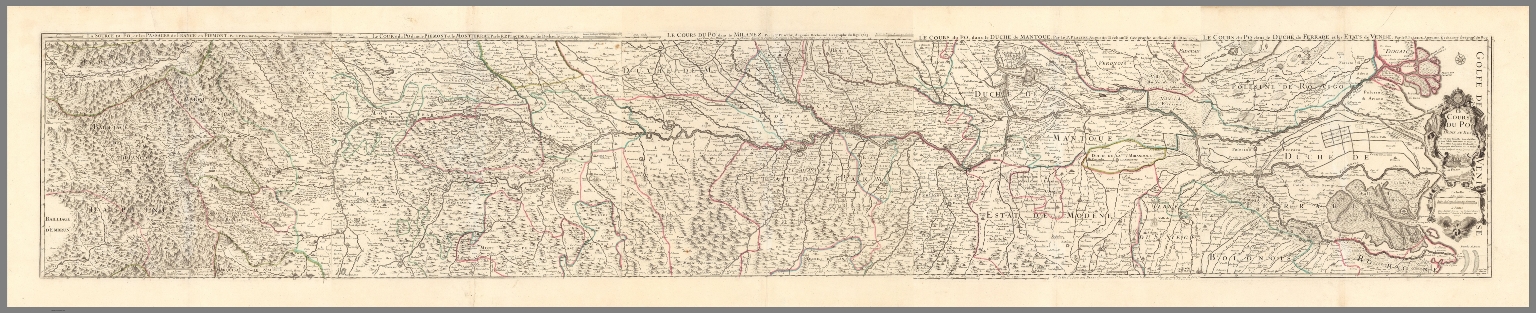
Full Title
(Composite map) Le cours du Po. Dedie au Roy. Par ... le P. Placide, Augustin dechausse, Geographe Ordinaire de sa Majeste ...1703. A Paris, Chez Berey graveuer ... Grave par Berey. (At upper margin) Le cours du Po dans le duche de Ferrare et les etats de Venise. (to accompany) Cartes de geographie par Le Rd. Pere Placide.
List No
13031.044
Note
Composite map on 5 sheets. Illustrating the course of the Po River, in northern Italy.
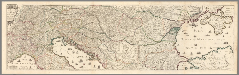
Author
[Placide de Sainte-Helene, 1648-1734, Du Val, Pierre, 1619-1683]
Full Title
(Composite Map) Le cours du Danube. Par ... le P. Placide, Augustin dechausse, Geographe Ordinaire de sa Majeste ... 1703. A Paris, Chez Berey ... C. A. Berey Sculp. (to accompany) Cartes de geographie par Le Rd. Pere Placide.
List No
13031.049
Note
Composite of map on 3 sheets. Illustrating the course of the Danube River, from its source to the Black Sea.
Author
Aa, Pieter van der, 1659-1733
Full Title
(Title Page to) Nouvel Atlas, tres-exact et fort commode pour toutes sortes de personnes, Contenant les Principales Cartes Geographiques. Dresse suivant les nouvelles observations de Mrs. de l'Academie Royale des Sciences, & rectifie sur les Relations les plus recentes des plus fideles voyageurs. A Leide, Chez Pierre Van der Aa, Marchand Libraire. Avec Privilege.
List No
11691.002
Note
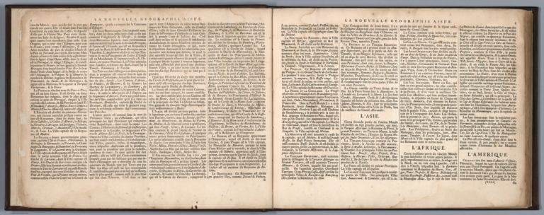
Van de Aa describes this book as a new atlas, which contains the principal geographical maps of modern long-journey voyages which have been made both by sea and by land in all parts of the world, and of the most famous routes for travelers from the year 1246 to 1696, drawn up according to the new observations of members of the Royal Academy of Sciences. Includes engraved hand colored pictorial title and dedication plates; 2 pages of introductory text “Avis au lecteur”, 4 pages of descriptive text; La Nouvelle Geographie Aisee, and manuscript index "Table des Nouvelles carte geographiques ...". Manuscript date "1686" on frontispiece. Pages numbered also in manuscript, 5-100, 98 maps numbered in manuscript, 6-100. Map number 46 is in 3 parts, 46A-46C. Maps are engraved and hand colored. There are many decorative title cartouches, including figures, cherubs, fauna and views. Showing political and administrative boundaries, major cities, towns, villages, rivers, lakes, landmarks, roads, forests and mountains. Relief shown pictorially. Some maps includes compass rose and notations. Bound in full leather covers, with Title "Atlas" embossed in gilt on spine. Pieter van der Aa, a Dutch publisher and printer was best known for his cartographic work. He opened a bookshop and publishing house in Leiden in 1677, and started his first business there in 1683. By 1694 he was made printer to Leiden University, and by 1715, he was appointed the official printer to the town of Leiden. His major work was the massive Galerie Agreable du Monde (1729) a compendium of some 3,000 plates in 66 volumes, published in an edition of 100 sets. Other publications included Atlas Nouveau et Curieux and Atlas Nouvel, both produced in 1714. Van der Aa also produced separately issued maps and reissued maps by other publishers, such as Les Forces de l’Europe (1726), originally published in 1696 by Nicolas de Fer.
Author
Aa, Pieter van der, 1659-1733
Full Title
(Text Page to) Nouvel Atlas, tres-exact et fort commode pour toutes sortes de personnes, Contenant les Principales Cartes Geographiques. Dresse suivant les nouvelles observations de Mrs. de l'Academie Royale des Sciences, & rectifie sur les Relations les plus recentes des plus fideles voyageurs. A Leide, Chez Pierre Van der Aa, Marchand Libraire. Avec Privilege.
List No
11691.003
Note
Van de Aa describes this book as a new atlas, which contains the principal geographical maps of modern long-journey voyages which have been made both by sea and by land in all parts of the world, and of the most famous routes for travelers from the year 1246 to 1696, drawn up according to the new observations of members of the Royal Academy of Sciences. Includes engraved hand colored pictorial title and dedication plates; 2 pages of introductory text “Avis au lecteur”, 4 pages of descriptive text; La Nouvelle Geographie Aisee, and manuscript index "Table des Nouvelles carte geographiques ...". Manuscript date "1686" on frontispiece. Pages numbered also in manuscript, 5-100, 98 maps numbered in manuscript, 6-100. Map number 46 is in 3 parts, 46A-46C. Maps are engraved and hand colored. There are many decorative title cartouches, including figures, cherubs, fauna and views. Showing political and administrative boundaries, major cities, towns, villages, rivers, lakes, landmarks, roads, forests and mountains. Relief shown pictorially. Some maps includes compass rose and notations. Bound in full leather covers, with Title "Atlas" embossed in gilt on spine. Pieter van der Aa, a Dutch publisher and printer was best known for his cartographic work. He opened a bookshop and publishing house in Leiden in 1677, and started his first business there in 1683. By 1694 he was made printer to Leiden University, and by 1715, he was appointed the official printer to the town of Leiden. His major work was the massive Galerie Agreable du Monde (1729) a compendium of some 3,000 plates in 66 volumes, published in an edition of 100 sets. Other publications included Atlas Nouveau et Curieux and Atlas Nouvel, both produced in 1714. Van der Aa also produced separately issued maps and reissued maps by other publishers, such as Les Forces de l’Europe (1726), originally published in 1696 by Nicolas de Fer.
Author
Aa, Pieter van der, 1659-1733
Full Title
Mappe monde : Suivant les nouvelles observations de Messrs ... A Leide, Chez Pierre Van der Aa. (to accompany) Nouvel Atlas, tres-exact et fort commode pour toutes sortes de personnes, Contenant les Principales Cartes Geographiques ...
List No
11691.010
Note
Full color double hemispherical world map, with decorative cartouches and views. Showing routes of Tasman, Magellan, and Mendana. Relief shown pictorially. Includes notation.
Author
Aa, Pieter van der, 1659-1733
Full Title
L'Amerique septentrionale, Suivant les nouvelles observations de Messrs ... A Leide, Chez Pierre Van der Aa. (to accompany) Nouvel Atlas, tres-exact et fort commode pour toutes sortes de personnes, Contenant les Principales Cartes Geographiques ...
List No
11691.101
Note
Full color map of North America and the West Indies. Centered on the Great lakes, covers from Baffin Bay to the Amerique Meridionale, including Florida, New Mexico, New Spain (Mexico), California, Nouvelle France, and the Hudson Bay. California is not clear whether it is an island or not. The Gulf of California is left open ended, Parts of California are identified as New Albion. The exploration routes used by d'Oliver, Cortez, and Drake are shown in dote lines to the west of Mexico. Map showing political and administrative boundaries and settlements. Relief shown pictorially. Includes decorative title cartouche.
Author
Aa, Pieter van der, 1659-1733
Full Title
La Floride, Suivant les nouvelles observations de Messrs ... A Leide, Chez Pierre Van der Aa. (to accompany) Nouvel Atlas, tres-exact et fort commode pour toutes sortes de personnes, Contenant les Principales Cartes Geographiques ...
List No
11691.102
Note
Full color map of Southern States. Covers part of Mexico, New Mexico, Texas, and Florida as far North as Illinois and Philadelphia, includes also the Carolinas, Virgina and Maryland. Map showing political and administrative boundaries, Native American settlements, major towns and villages. Relief shown pictorially. Includes decorative title cartouche.
Author
Aa, Pieter van der, 1659-1733
Full Title
Canada, ou, Nouvelle France, Suivant les nouvelles observations de Messrs ... A Leide, Chez Pierre Van der Aa. (to accompany) Nouvel Atlas, tres-exact et fort commode pour toutes sortes de personnes, Contenant les Principales Cartes Geographiques ...
List No
11691.103
Note
Full color map of Canada. Showing Great lakes and Hudson Bay, administrative boundaries, major towns and villages. The exploratory routes shown in dote lines. Relief shown pictorially. Includes decorative title cartouche and explanation notes.
Author
Fer, Nicolas de, 1646-1720
Full Title
Diocese De L'Archevesche De Paris.
List No
10022.016
Author
Fer, Nicolas de, 1646-1720
Full Title
Le Principaute de Catalogne : divisee en vigueries
List No
10022.068
Author
[Rossi, Giovanni Giacomo de, 1627-1691, Cantelli, Giacomo, 1643-1695, Rossi, Domenico de, 1647-1729, Rossi, Lorenzo Filippo de.]
Full Title
Provincia di Terra di Lavoro : gia delineata dal Magini in ogni sva parte e nvovamente ampliata secondo lo stato presente. Data ata in luce da Domenico de Rossi. e Dedicata all'ill.mo e rev.mo Sig.re Monsig.r Gio. Maria Lancisi ... Lorenzo Filippo de Rossi. Data in luce da Domenico de Rossi dalle sue stampe in Roma alla Pace, con priuilegio del sommo pontefice l'Anno 1714. (To accompany) Mercurio geografico overo Guida geografica in tutte le parti del mondo conforme le tavole di Giacomo Cantelli da Vignola ... Tomo secondo ... l'anno 1692. (Map 134).
List No
11438.115
Note
Outline hand colored map, with decorative cartouche. Relief shown pictorially. Shows administrative divisions, cities, towns, landmarks, churches, forests, rivers and mountains. Includes note and dedication text.
Author
[Rossi, Giovanni Giacomo de, 1627-1691, Cantelli, Giacomo, 1643-1695, Rossi, Domenico de, 1647-1729, Magini, Giovanni Antonio, Pietrasanta, Giuseppe]
Full Title
Provincie del contado di Molise e principato vltra : gia delineate dal Magini e nvovamente ampliate secondo lo stato presente. Date in luce da Domenico de Rossi. Dedicate all'ill.mo e reu.mo Sig.re Monsig.r Troiano Acquauiua d'Aragona cameriero d'onore della S. di N. S. papa Clemente XI. In Roma : nella stamperia alla Pace con priuilegio del som. pont. l'Anno 1714. Giuseppe Pietrasanta incidit. (To accompany) Mercurio geografico overo Guida geografica in tutte le parti del mondo conforme le tavole di Giacomo Cantelli da Vignola ... Tomo secondo ... l'anno 1692. (Map 135).
List No
11438.116
Note
Outline hand colored map, with decorative cartouche. Relief shown pictorially. Shows administrative divisions, cities, towns, landmarks, churches, forests, rivers, volcanoe and mountains. Includes note and dedication text.
Author
[Rossi, Giovanni Giacomo de, 1627-1691, Cantelli, Giacomo, 1643-1695, Rossi, Domenico de, 1647-1729, Magini, Giovanni Antonio, Pietrasanta, Giuseppe]
Full Title
Provincia di Capitanata : gia delineata dal Magini e nvovamente ampliata secondo lo stato presente : e dedicata all'ill.mo Sigre. il Sigr. Barone Carlo Alberto Guidobono Caualchini ... Domenico de Rossi. Data in luce da Domenico de Rossi dalle sue stampe in Roma alla Pace con priuilegio del sommo. pont. l'Anno 1714. Giuseppe Pietrasanta incidit. (To accompany) Mercurio geografico overo Guida geografica in tutte le parti del mondo conforme le tavole di Giacomo Cantelli da Vignola ... Tomo secondo ... l'anno 1692. (Map 136).
List No
11438.117
Note
Outline hand colored map, with decorative cartouche. Relief shown pictorially. Shows administrative divisions, cities, towns, landmarks, churches, forests, rivers, volcanoe and mountains. Includes note and dedication text.
Author
[Rossi, Giovanni Giacomo de, 1627-1691, Cantelli, Giacomo, 1643-1695, Rossi, Domenico de, 1647-1729, Magini, Giovanni Antonio, Pietrasanta, Giuseppe]
Full Title
Provincia del Principato Citra : gia delineata dal Magini e nvovamente ampliata secondo lo stato presente : Data in luce da Domenico de Rossi, e dedicata all'ill.mo Sig.re il Sig.r auocato Diego de Pace. In Roma : nella stamperia alla Pace con priuilegio del sommo. pont. l'Anno 1714. Giuseppe Pietrasanta incidit. (To accompany) Mercurio geografico overo Guida geografica in tutte le parti del mondo conforme le tavole di Giacomo Cantelli da Vignola ... Tomo secondo ... l'anno 1692. (Map 137).
List No
11438.118
Note
Outline hand colored map, with decorative cartouche. Relief shown pictorially. Shows administrative divisions, cities, towns, landmarks, churches, forests, rivers, volcanoe and mountains. Includes note and dedication text.
Author
[Rossi, Giovanni Giacomo de, 1627-1691, Cantelli, Giacomo, 1643-1695, Rossi, Domenico de, 1647-1729, Magini, Giovanni Antonio, Pietrasanta, Giuseppe]
Full Title
Provincie di Basilicata e Terra di Bari : gia delineata dal Magini e nvovamente ampliata secondo lo stato presente : Data in luce da Domenico de Rossi, e dedicate all'ill.mo Sigre. il Sigr. Caualiere Curzio Segardi. Data in luce da Domenico de Rossi, dalle sue stampe in Roma alla Pace con priuilegio del S. P. l'anno 1714. Giuseppe Pietrasanta incidit. (To accompany) Mercurio geografico overo Guida geografica in tutte le parti del mondo conforme le tavole di Giacomo Cantelli da Vignola ... Tomo secondo ... l'anno 1692. (Map 138).
List No
11438.119
Note
Outline hand colored map, with decorative cartouche. Relief shown pictorially. Shows administrative divisions, cities, towns, landmarks, churches, forests, rivers, volcanoe and mountains. Includes note and dedication text.
Author
[Rossi, Giovanni Giacomo de, 1627-1691, Cantelli, Giacomo, 1643-1695, Rossi, Domenico de, 1647-1729, Magini, Giovanni Antonio]
Full Title
Provincia di terra d'Otranto : gia delineata dal Magini e nvovamente ampliata in ogni sva parte secondo lo stato presente : Data in luce da Domenico de Rossi, e dedicata all'imparegiabile virtù, e merito dell'ill.mo, e reu.mo Sig.re Monsig.r Francesco Maria d'Aste ... Data in luce da Domenico de Rossi, dalle sue stampe in Roma alla Pace con priu. del sommo pontefice l'Anno 1714. (To accompany) Mercurio geografico overo Guida geografica in tutte le parti del mondo conforme le tavole di Giacomo Cantelli da Vignola ... Tomo secondo ... l'anno 1692. (Map 139).
List No
11438.120
Note
Outline hand colored map, with decorative cartouche. Relief shown pictorially. Shows administrative divisions, cities, towns, landmarks, churches, forests, rivers, volcanoe and mountains. Includes note and dedication text.
Author
[Rossi, Giovanni Giacomo de, 1627-1691, Cantelli, Giacomo, 1643-1695, Rossi, Domenico de, 1647-1729, Magini, Giovanni Antonio, Pietrasanta, Giuseppe]
Full Title
Provincia di Calabria Citra : gia delineata dal Magini e nvovamente ampliata secondo lo stato presente : Data in luce da Domenico de Rossi, e dedicate all'ill.mo Sig.re il Sig.r Rinaldo Buoninsegni. Nella stamperia di Domenico de Rossi in Roma alla Pace, con priuilegio del sommo pontefice, l'Anno 1714. Giuseppe Pietrasanta incidit. (To accompany) Mercurio geografico overo Guida geografica in tutte le parti del mondo conforme le tavole di Giacomo Cantelli da Vignola ... Tomo secondo ... l'anno 1692. (Map 140).
List No
11438.121
Note
Outline hand colored map, with decorative cartouche. Relief shown pictorially. Shows administrative divisions, cities, towns, landmarks, churches, forests, rivers and mountains. Includes note and dedication text.
Author
[Rossi, Giovanni Giacomo de, 1627-1691, Cantelli, Giacomo, 1643-1695, Rossi, Domenico de, 1647-1729, Magini, Giovanni Antonio, Pietrasanta, Giuseppe]
Full Title
Provincia di Calabria Vltra : gia delineata dal Magini e nvovamente ampliata secondo lo stato presente : Dedicate all' illmo. sigre. il Sigre. Caualre. Giulio del Taia ... Domenico de Rossi. Data in luce da Domenico de Rossi dalle sue stampe in Roma alla Pace con priuil. del S. Pont., l'anno 1714. Giuseppe Pietrasanta incidit. (To accompany) Mercurio geografico overo Guida geografica in tutte le parti del mondo conforme le tavole di Giacomo Cantelli da Vignola ... Tomo secondo ... l'anno 1692. (Map 141).
List No
11438.122
Note
Outline hand colored map, with decorative cartouche. Relief shown pictorially. Shows administrative divisions, cities, towns, landmarks, churches, forests, rivers and mountains. Includes note and dedication text.
Author
Aa, Pieter van der, 1659-1733
Full Title
(Covers to) Nouvel Atlas, tres-exact et fort commode pour toutes sortes de personnes, Contenant les Principales Cartes Geographiques. Dresse suivant les nouvelles observations de Mrs. de l'Academie Royale des Sciences, & rectifie sur les Relations les plus recentes des plus fideles voyageurs. A Leide, Chez Pierre Van der Aa, Marchand Libraire. Avec Privilege.
List No
11691.001
Note
Van de Aa describes this book as a new atlas, which contains the principal geographical maps of modern long-journey voyages which have been made both by sea and by land in all parts of the world, and of the most famous routes for travelers from the year 1246 to 1696, drawn up according to the new observations of members of the Royal Academy of Sciences. Includes engraved hand colored pictorial title and dedication plates; 2 pages of introductory text “Avis au lecteur”, 4 pages of descriptive text; La Nouvelle Geographie Aisee, and manuscript index "Table des Nouvelles carte geographiques ...". Manuscript date "1686" on frontispiece. Pages numbered also in manuscript, 5-100, 98 maps numbered in manuscript, 6-100. Map number 46 is in 3 parts, 46A-46C. Maps are engraved and hand colored. There are many decorative title cartouches, including figures, cherubs, fauna and views. Showing political and administrative boundaries, major cities, towns, villages, rivers, lakes, landmarks, roads, forests and mountains. Relief shown pictorially. Some maps includes compass rose and notations. Bound in full leather covers, with Title "Atlas" embossed in gilt on spine. Pieter van der Aa, a Dutch publisher and printer was best known for his cartographic work. He opened a bookshop and publishing house in Leiden in 1677, and started his first business there in 1683. By 1694 he was made printer to Leiden University, and by 1715, he was appointed the official printer to the town of Leiden. His major work was the massive Galerie Agreable du Monde (1729) a compendium of some 3,000 plates in 66 volumes, published in an edition of 100 sets. Other publications included Atlas Nouveau et Curieux and Atlas Nouvel, both produced in 1714. Van der Aa also produced separately issued maps and reissued maps by other publishers, such as Les Forces de l’Europe (1726), originally published in 1696 by Nicolas de Fer.
Author
Aa, Pieter van der, 1659-1733
Full Title
(Text Page to) Nouvel Atlas, tres-exact et fort commode pour toutes sortes de personnes, Contenant les Principales Cartes Geographiques. Dresse suivant les nouvelles observations de Mrs. de l'Academie Royale des Sciences, & rectifie sur les Relations les plus recentes des plus fideles voyageurs. A Leide, Chez Pierre Van der Aa, Marchand Libraire. Avec Privilege.
List No
11691.004
Note
Van de Aa describes this book as a new atlas, which contains the principal geographical maps of modern long-journey voyages which have been made both by sea and by land in all parts of the world, and of the most famous routes for travelers from the year 1246 to 1696, drawn up according to the new observations of members of the Royal Academy of Sciences. Includes engraved hand colored pictorial title and dedication plates; 2 pages of introductory text “Avis au lecteur”, 4 pages of descriptive text; La Nouvelle Geographie Aisee, and manuscript index "Table des Nouvelles carte geographiques ...". Manuscript date "1686" on frontispiece. Pages numbered also in manuscript, 5-100, 98 maps numbered in manuscript, 6-100. Map number 46 is in 3 parts, 46A-46C. Maps are engraved and hand colored. There are many decorative title cartouches, including figures, cherubs, fauna and views. Showing political and administrative boundaries, major cities, towns, villages, rivers, lakes, landmarks, roads, forests and mountains. Relief shown pictorially. Some maps includes compass rose and notations. Bound in full leather covers, with Title "Atlas" embossed in gilt on spine. Pieter van der Aa, a Dutch publisher and printer was best known for his cartographic work. He opened a bookshop and publishing house in Leiden in 1677, and started his first business there in 1683. By 1694 he was made printer to Leiden University, and by 1715, he was appointed the official printer to the town of Leiden. His major work was the massive Galerie Agreable du Monde (1729) a compendium of some 3,000 plates in 66 volumes, published in an edition of 100 sets. Other publications included Atlas Nouveau et Curieux and Atlas Nouvel, both produced in 1714. Van der Aa also produced separately issued maps and reissued maps by other publishers, such as Les Forces de l’Europe (1726), originally published in 1696 by Nicolas de Fer.
Author
Aa, Pieter van der, 1659-1733
Full Title
(Text Page to) Nouvel Atlas, tres-exact et fort commode pour toutes sortes de personnes, Contenant les Principales Cartes Geographiques. Dresse suivant les nouvelles observations de Mrs. de l'Academie Royale des Sciences, & rectifie sur les Relations les plus recentes des plus fideles voyageurs. A Leide, Chez Pierre Van der Aa, Marchand Libraire. Avec Privilege.
List No
11691.005
Note
Van de Aa describes this book as a new atlas, which contains the principal geographical maps of modern long-journey voyages which have been made both by sea and by land in all parts of the world, and of the most famous routes for travelers from the year 1246 to 1696, drawn up according to the new observations of members of the Royal Academy of Sciences. Includes engraved hand colored pictorial title and dedication plates; 2 pages of introductory text “Avis au lecteur”, 4 pages of descriptive text; La Nouvelle Geographie Aisee, and manuscript index "Table des Nouvelles carte geographiques ...". Manuscript date "1686" on frontispiece. Pages numbered also in manuscript, 5-100, 98 maps numbered in manuscript, 6-100. Map number 46 is in 3 parts, 46A-46C. Maps are engraved and hand colored. There are many decorative title cartouches, including figures, cherubs, fauna and views. Showing political and administrative boundaries, major cities, towns, villages, rivers, lakes, landmarks, roads, forests and mountains. Relief shown pictorially. Some maps includes compass rose and notations. Bound in full leather covers, with Title "Atlas" embossed in gilt on spine. Pieter van der Aa, a Dutch publisher and printer was best known for his cartographic work. He opened a bookshop and publishing house in Leiden in 1677, and started his first business there in 1683. By 1694 he was made printer to Leiden University, and by 1715, he was appointed the official printer to the town of Leiden. His major work was the massive Galerie Agreable du Monde (1729) a compendium of some 3,000 plates in 66 volumes, published in an edition of 100 sets. Other publications included Atlas Nouveau et Curieux and Atlas Nouvel, both produced in 1714. Van der Aa also produced separately issued maps and reissued maps by other publishers, such as Les Forces de l’Europe (1726), originally published in 1696 by Nicolas de Fer.
Author
Aa, Pieter van der, 1659-1733
Full Title
(Text Page to) Nouvel Atlas, tres-exact et fort commode pour toutes sortes de personnes, Contenant les Principales Cartes Geographiques. Dresse suivant les nouvelles observations de Mrs. de l'Academie Royale des Sciences, & rectifie sur les Relations les plus recentes des plus fideles voyageurs. A Leide, Chez Pierre Van der Aa, Marchand Libraire. Avec Privilege.
List No
11691.006
Note
Van de Aa describes this book as a new atlas, which contains the principal geographical maps of modern long-journey voyages which have been made both by sea and by land in all parts of the world, and of the most famous routes for travelers from the year 1246 to 1696, drawn up according to the new observations of members of the Royal Academy of Sciences. Includes engraved hand colored pictorial title and dedication plates; 2 pages of introductory text “Avis au lecteur”, 4 pages of descriptive text; La Nouvelle Geographie Aisee, and manuscript index "Table des Nouvelles carte geographiques ...". Manuscript date "1686" on frontispiece. Pages numbered also in manuscript, 5-100, 98 maps numbered in manuscript, 6-100. Map number 46 is in 3 parts, 46A-46C. Maps are engraved and hand colored. There are many decorative title cartouches, including figures, cherubs, fauna and views. Showing political and administrative boundaries, major cities, towns, villages, rivers, lakes, landmarks, roads, forests and mountains. Relief shown pictorially. Some maps includes compass rose and notations. Bound in full leather covers, with Title "Atlas" embossed in gilt on spine. Pieter van der Aa, a Dutch publisher and printer was best known for his cartographic work. He opened a bookshop and publishing house in Leiden in 1677, and started his first business there in 1683. By 1694 he was made printer to Leiden University, and by 1715, he was appointed the official printer to the town of Leiden. His major work was the massive Galerie Agreable du Monde (1729) a compendium of some 3,000 plates in 66 volumes, published in an edition of 100 sets. Other publications included Atlas Nouveau et Curieux and Atlas Nouvel, both produced in 1714. Van der Aa also produced separately issued maps and reissued maps by other publishers, such as Les Forces de l’Europe (1726), originally published in 1696 by Nicolas de Fer.
Author
Aa, Pieter van der, 1659-1733
Full Title
(Text Page to) Nouvel Atlas, tres-exact et fort commode pour toutes sortes de personnes, Contenant les Principales Cartes Geographiques. Dresse suivant les nouvelles observations de Mrs. de l'Academie Royale des Sciences, & rectifie sur les Relations les plus recentes des plus fideles voyageurs. A Leide, Chez Pierre Van der Aa, Marchand Libraire. Avec Privilege.
List No
11691.007
Note
Van de Aa describes this book as a new atlas, which contains the principal geographical maps of modern long-journey voyages which have been made both by sea and by land in all parts of the world, and of the most famous routes for travelers from the year 1246 to 1696, drawn up according to the new observations of members of the Royal Academy of Sciences. Includes engraved hand colored pictorial title and dedication plates; 2 pages of introductory text “Avis au lecteur”, 4 pages of descriptive text; La Nouvelle Geographie Aisee, and manuscript index "Table des Nouvelles carte geographiques ...". Manuscript date "1686" on frontispiece. Pages numbered also in manuscript, 5-100, 98 maps numbered in manuscript, 6-100. Map number 46 is in 3 parts, 46A-46C. Maps are engraved and hand colored. There are many decorative title cartouches, including figures, cherubs, fauna and views. Showing political and administrative boundaries, major cities, towns, villages, rivers, lakes, landmarks, roads, forests and mountains. Relief shown pictorially. Some maps includes compass rose and notations. Bound in full leather covers, with Title "Atlas" embossed in gilt on spine. Pieter van der Aa, a Dutch publisher and printer was best known for his cartographic work. He opened a bookshop and publishing house in Leiden in 1677, and started his first business there in 1683. By 1694 he was made printer to Leiden University, and by 1715, he was appointed the official printer to the town of Leiden. His major work was the massive Galerie Agreable du Monde (1729) a compendium of some 3,000 plates in 66 volumes, published in an edition of 100 sets. Other publications included Atlas Nouveau et Curieux and Atlas Nouvel, both produced in 1714. Van der Aa also produced separately issued maps and reissued maps by other publishers, such as Les Forces de l’Europe (1726), originally published in 1696 by Nicolas de Fer.
Author
Aa, Pieter van der, 1659-1733
Full Title
(Text Page to) Nouvel Atlas, tres-exact et fort commode pour toutes sortes de personnes, Contenant les Principales Cartes Geographiques. Dresse suivant les nouvelles observations de Mrs. de l'Academie Royale des Sciences, & rectifie sur les Relations les plus recentes des plus fideles voyageurs. A Leide, Chez Pierre Van der Aa, Marchand Libraire. Avec Privilege.
List No
11691.008
Note
Van de Aa describes this book as a new atlas, which contains the principal geographical maps of modern long-journey voyages which have been made both by sea and by land in all parts of the world, and of the most famous routes for travelers from the year 1246 to 1696, drawn up according to the new observations of members of the Royal Academy of Sciences. Includes engraved hand colored pictorial title and dedication plates; 2 pages of introductory text “Avis au lecteur”, 4 pages of descriptive text; La Nouvelle Geographie Aisee, and manuscript index "Table des Nouvelles carte geographiques ...". Manuscript date "1686" on frontispiece. Pages numbered also in manuscript, 5-100, 98 maps numbered in manuscript, 6-100. Map number 46 is in 3 parts, 46A-46C. Maps are engraved and hand colored. There are many decorative title cartouches, including figures, cherubs, fauna and views. Showing political and administrative boundaries, major cities, towns, villages, rivers, lakes, landmarks, roads, forests and mountains. Relief shown pictorially. Some maps includes compass rose and notations. Bound in full leather covers, with Title "Atlas" embossed in gilt on spine. Pieter van der Aa, a Dutch publisher and printer was best known for his cartographic work. He opened a bookshop and publishing house in Leiden in 1677, and started his first business there in 1683. By 1694 he was made printer to Leiden University, and by 1715, he was appointed the official printer to the town of Leiden. His major work was the massive Galerie Agreable du Monde (1729) a compendium of some 3,000 plates in 66 volumes, published in an edition of 100 sets. Other publications included Atlas Nouveau et Curieux and Atlas Nouvel, both produced in 1714. Van der Aa also produced separately issued maps and reissued maps by other publishers, such as Les Forces de l’Europe (1726), originally published in 1696 by Nicolas de Fer.
Author
Aa, Pieter van der, 1659-1733
Full Title
(Index Page to) Nouvel Atlas, tres-exact et fort commode pour toutes sortes de personnes, Contenant les Principales Cartes Geographiques. Dresse suivant les nouvelles observations de Mrs. de l'Academie Royale des Sciences, & rectifie sur les Relations les plus recentes des plus fideles voyageurs. A Leide, Chez Pierre Van der Aa, Marchand Libraire. Avec Privilege.
List No
11691.009
Note
Van de Aa describes this book as a new atlas, which contains the principal geographical maps of modern long-journey voyages which have been made both by sea and by land in all parts of the world, and of the most famous routes for travelers from the year 1246 to 1696, drawn up according to the new observations of members of the Royal Academy of Sciences. Includes engraved hand colored pictorial title and dedication plates; 2 pages of introductory text “Avis au lecteur”, 4 pages of descriptive text; La Nouvelle Geographie Aisee, and manuscript index "Table des Nouvelles carte geographiques ...". Manuscript date "1686" on frontispiece. Pages numbered also in manuscript, 5-100, 98 maps numbered in manuscript, 6-100. Map number 46 is in 3 parts, 46A-46C. Maps are engraved and hand colored. There are many decorative title cartouches, including figures, cherubs, fauna and views. Showing political and administrative boundaries, major cities, towns, villages, rivers, lakes, landmarks, roads, forests and mountains. Relief shown pictorially. Some maps includes compass rose and notations. Bound in full leather covers, with Title "Atlas" embossed in gilt on spine. Pieter van der Aa, a Dutch publisher and printer was best known for his cartographic work. He opened a bookshop and publishing house in Leiden in 1677, and started his first business there in 1683. By 1694 he was made printer to Leiden University, and by 1715, he was appointed the official printer to the town of Leiden. His major work was the massive Galerie Agreable du Monde (1729) a compendium of some 3,000 plates in 66 volumes, published in an edition of 100 sets. Other publications included Atlas Nouveau et Curieux and Atlas Nouvel, both produced in 1714. Van der Aa also produced separately issued maps and reissued maps by other publishers, such as Les Forces de l’Europe (1726), originally published in 1696 by Nicolas de Fer.
Author
Aa, Pieter van der, 1659-1733
Full Title
L'Europe : Suivant les nouvelles observations de Messrs ... A Leide, Chez Pierre Van der Aa. (to accompany) Nouvel Atlas, tres-exact et fort commode pour toutes sortes de personnes, Contenant les Principales Cartes Geographiques ...
List No
11691.011
Note
Full color map of Europe, with decorative cartouche. Showing Political divisions. Relief shown pictorially.
Author
Aa, Pieter van der, 1659-1733
Full Title
Les Isles Britanniques : Suivant les nouvelles observations de Messrs ... A Leide, Chez Pierre Van der Aa. (to accompany) Nouvel Atlas, tres-exact et fort commode pour toutes sortes de personnes, Contenant les Principales Cartes Geographiques ...
List No
11691.012
Note
Full color map of British Isles , with decorative cartouche. Showing Political divisions. Relief shown pictorially. Includes notation.
Author
Aa, Pieter van der, 1659-1733
Full Title
Les Isles Britanniques : Suivant les nouvelles observations de Messrs ... A Leide, Chez Pierre Van der Aa. (to accompany) Nouvel Atlas, tres-exact et fort commode pour toutes sortes de personnes, Contenant les Principales Cartes Geographiques ...
List No
11691.013
Note
Full color map of British Isles, with decorative cartouche. Showing Political divisions. Relief shown pictorially.
Author
Aa, Pieter van der, 1659-1733
Full Title
L'Ecosse : Suivant les nouvelles observations de Messrs ... A Leide, Chez Pierre Van der Aa. (to accompany) Nouvel Atlas, tres-exact et fort commode pour toutes sortes de personnes, Contenant les Principales Cartes Geographiques ...
List No
11691.014
Note
Full color map of Scotland, with decorative cartouche. Showing administrative divisions. Relief shown pictorially.
Author
Aa, Pieter van der, 1659-1733
Full Title
L'Irlande : Suivant les nouvelles observations de Messrs ... A Leide, Chez Pierre Van der Aa. (to accompany) Nouvel Atlas, tres-exact et fort commode pour toutes sortes de personnes, Contenant les Principales Cartes Geographiques ...
List No
11691.015
Note
Full color map of Ireland, with decorative cartouche. Showing administrative divisions. Relief shown pictorially.
Author
Aa, Pieter van der, 1659-1733
Full Title
Scandinavie septentrionale ou couronnes du nord. Suivant les nouvelles observations de Messrs ... A Leide, Chez Pierre Van der Aa. (to accompany) Nouvel Atlas, tres-exact et fort commode pour toutes sortes de personnes, Contenant les Principales Cartes Geographiques ...
List No
11691.016
Note
Full color map of the Northern part of Scandinavia, with decorative cartouche. Showing political divisions. Relief shown pictorially.
Author
Aa, Pieter van der, 1659-1733
Full Title
Scandinavie meridionale ou couronnes du nord. Suivant les nouvelles observations de Messrs ... A Leide, Chez Pierre Van der Aa. (to accompany) Nouvel Atlas, tres-exact et fort commode pour toutes sortes de personnes, Contenant les Principales Cartes Geographiques ...
List No
11691.017
Note
Full color map of the Southern part of Scandinavia, with decorative cartouche. Showing political divisions. Relief shown pictorially.
Author
Aa, Pieter van der, 1659-1733
Full Title
Le Danemarc : Suivant les nouvelles observations de Messrs ... A Leide, Chez Pierre Van der Aa. (to accompany) Nouvel Atlas, tres-exact et fort commode pour toutes sortes de personnes, Contenant les Principales Cartes Geographiques ...
List No
11691.018
Note
Full color map of Denmark, with decorative cartouche. Showing boundaries. Relief shown pictorially.
Author
Aa, Pieter van der, 1659-1733
Full Title
La Norvegue : Suivant les nouvelles observations de Messrs ... A Leide, Chez Pierre Van der Aa. (to accompany) Nouvel Atlas, tres-exact et fort commode pour toutes sortes de personnes, Contenant les Principales Cartes Geographiques ...
List No
11691.019
Note
Full color map of Denmark, with decorative cartouche. Showing administrative boundaries. Relief shown pictorially.
Author
Aa, Pieter van der, 1659-1733
Full Title
La Suede : Suivant les nouvelles observations de Messrs ... A Leide, Chez Pierre Van der Aa. (to accompany) Nouvel Atlas, tres-exact et fort commode pour toutes sortes de personnes, Contenant les Principales Cartes Geographiques ...
List No
11691.020
Note
Full color map of Sweden, with decorative cartouche. Showing administrative boundaries. Relief shown pictorially.
Author
Aa, Pieter van der, 1659-1733
Full Title
La Moscovie septentrionale : Suivant les nouvelles observations de Messrs ... A Leide, Chez Pierre Van der Aa. (to accompany) Nouvel Atlas, tres-exact et fort commode pour toutes sortes de personnes, Contenant les Principales Cartes Geographiques ...
List No
11691.021
Note
Full color map of northern part of European Russia. with decorative cartouche. Showing administrative boundaries. Relief shown pictorially.
Author
Aa, Pieter van der, 1659-1733
Full Title
La Moscovie meridionale : Suivant les nouvelles observations de Messrs ... A Leide, Chez Pierre Van der Aa. (to accompany) Nouvel Atlas, tres-exact et fort commode pour toutes sortes de personnes, Contenant les Principales Cartes Geographiques ...
List No
11691.022
Note
Full color map of Southern part of European Russia. with decorative cartouche. Showing administrative boundaries. Relief shown pictorially.
Author
Aa, Pieter van der, 1659-1733
Full Title
La Pologne, Suivant les nouvelles observations de Messrs ... A Leide, Chez Pierre Van der Aa. (to accompany) Nouvel Atlas, tres-exact et fort commode pour toutes sortes de personnes, Contenant les Principales Cartes Geographiques ...
List No
11691.023
Note
Full color map of Poland. with decorative cartouche. Showing administrative boundaries. Relief shown pictorially.
Author
Aa, Pieter van der, 1659-1733
Full Title
La Prusse, Suivant les nouvelles observations de Messrs ... A Leide, Chez Pierre Van der Aa. (to accompany) Nouvel Atlas, tres-exact et fort commode pour toutes sortes de personnes, Contenant les Principales Cartes Geographiques ...
List No
11691.024
Note
Full color map of Prussia (Germany), Poland and Lithuania, with decorative cartouche. Showing administrative boundaries. Relief shown pictorially.
Author
Aa, Pieter van der, 1659-1733
Full Title
La Hongrie, Suivant les nouvelles observations de Messrs ... A Leide, Chez Pierre Van der Aa. (to accompany) Nouvel Atlas, tres-exact et fort commode pour toutes sortes de personnes, Contenant les Principales Cartes Geographiques ...
List No
11691.025
Note
Full color map of Hungary, with decorative cartouche. Showing administrative boundaries. Relief shown pictorially.
Author
Aa, Pieter van der, 1659-1733
Full Title
L'Allemagne, Suivant les nouvelles observations de Messrs ... A Leide, Chez Pierre Van der Aa. (to accompany) Nouvel Atlas, tres-exact et fort commode pour toutes sortes de personnes, Contenant les Principales Cartes Geographiques ...
List No
11691.026
Note
Full color map of Germany, with decorative cartouche. Showing administrative boundaries. Relief shown pictorially.
Author
Aa, Pieter van der, 1659-1733
Full Title
La Boheme : Suivant les nouvelles observations de Messrs ... A Leide, Chez Pierre Van der Aa. (to accompany) Nouvel Atlas, tres-exact et fort commode pour toutes sortes de personnes, Contenant les Principales Cartes Geographiques ...
List No
11691.027
Note
Full color map of the Bohemia, Czech Republic, with decorative cartouche. Showing administrative boundaries. Relief shown pictorially.
|