|
REFINE
Browse All : World Atlas and Physical and Atlas Map of Russia
1-49 of 49
Author
[Baranov, Anatolij Nikolaevič, Soviet Union. Glavnoe upravlenie geodezii i kartografii]
Full Title
Soiuz Sovetskikh Sotsialisticheskikh Respublik : Fizicheskaia karta. 9-10. Atlas Mira : 1954.
List No
13682.022
Note
Physical map of the USSR. Relief shown by shading, gradient tints, and spot heights; Depths by Depths by bathymetric tints, isolines and soundings. Includes Great Circle nautical Scale and color coded reference.
Author
[Baranov, Anatolij Nikolaevič, Soviet Union. Glavnoe upravlenie geodezii i kartografii]
Full Title
Прибайкалье и Забайкалье = Pribaykal'ye i Zabaykal'ye. 73-74. Atlas Mira : 1954.
List No
13682.087
Note
Physical map of the Trans-Baikal Territory is part of the Siberian Federal District. Relief shown by gradient tints, contours and spotlights. Depth shown by bathymetric tints, isolines and soundings.
Author
[Gorkin, Aleksandr Fedorovich, Motylev, V.E.]
Full Title
Relef Soiuza SSR (profili). (to accompany) Bolshoi Sovietskii Atlas Mira. Moskva 1937.
List No
11008.101
Note
Color relief profile of the Soviet Union. Relief shown gradient tints and spot heights. Includes charts and reference.
Author
[Gorkin, Aleksandr Fedorovich, Motylev, V.E.]
Full Title
Fizicheskaya karta soyuza SSR. (to accompany) Bolshoi Sovietskii Atlas Mira. Moskva 1937.
List No
11008.183
Note
Cover to physical map of the USSR. Relief shown by gradient tints. Depth shown by bathymetric tints.
Author
[Gorkin, Aleksandr Fedorovich, Motylev, V.E.]
Full Title
Fizicheskaia karta yevropeyskoi chasti SSSR. (to accompany) Bolshoi Sovietskii Atlas Mira. Moskva 1937.
List No
11008.098
Note
Color physical map of Russia in Europe on 2 sheets. Showing cities and towns capitals, rivers, lakes, etc. Relief shown by shadings and spot heights. Depth shown by isolines and soundings. Includes explanation to symbols.
Author
[Gorkin, Aleksandr Fedorovich, Motylev, V.E.]
Full Title
Vechnaia merzlota. Chetvertichnye oledeneniia. Tektonicheskaia karta SSSR. (to accompany) Bolshoi Sovietskii Atlas Mira. Moskva 1937.
List No
11008.100
Note
3 color maps on 1 sheet. Including permafrost map, Quaternary glaciation map, and Tectonic map of the USSR. Each map includes color coded reference.
Author
[Gorkin, Aleksandr Fedorovich, Kutafʹev, S. A.]
Full Title
Fizicheskaia karta : Chernogo i Azovskogo Morey. Fizicheskaia karta : Kaspiyskogo Moria. Bolshoi Sovietskii Atlas Mira II. Moskva 1939.
List No
11008.251
Note
Physical maps on double page, 51x61. Covers of the Black and Azov and Caspian Seas. Shows sea currents.
Author
[Gorkin, Aleksandr Fedorovich, Kutafʹev, S. A.]
Full Title
Fizicheskaia karta : Severnoy Chasti Urala. Fizicheskaia karta : Yuzhnoy Chasti Urala. Bolshoi Sovietskii Atlas Mira II. Moskva 1939.
List No
11008.253
Note
2 physical maps on double page, 51x61. Covers the Northern and Southern parts of Urals.
Author
[Gorkin, Aleksandr Fedorovich, Kutafʹev, S. A.]
Full Title
RSFSR : Irkutskaia, Chitinskaia oblast' i Buryat-Mongol'skaia ASSR. Bolshoi Sovietskii Atlas Mira II. Moskva 1939.
List No
11008.271
Note
Double page map of Irkutsk, Chita regions and Buryat-Mongolian ASSR on sheet 51x61. Includes 2 insets. .
Author
[Gorkin, Aleksandr Fedorovich, Kutafʹev, S. A.]
Full Title
Turkmenskaia SSR. Bolshoi Sovietskii Atlas Mira II. Moskva 1939.
List No
11008.311
Note
Map of Turkmenistan on sheet 51x61. Includes 2 insets.
Author
Heck, Johann Georg, -1857
Full Title
Plate 25. Europaeisches Russland.
List No
12190.263
Author
[Sydow, Emil von., 1812-1873, Wagner, Hermann, 1840-1929]
Full Title
Ost-Europa. Gotha : Justus Perthes. Sydow-Wagners method. Schul-Atlas. XXII.
List No
13558.114
Note
Map of Eastern and part of Northern Europe. Bonne'sche Projektion.
Author
[Sydow, Emil von., 1812-1873, Wagner, Hermann, 1840-1929]
Full Title
Moskau. Leningrad. Ost-Europa. Gotha : Justus Perthes. Sydow-Wagners method. Schul-Atlas. XXII.
List No
13558.115
Note
2 maps on 1 sheet.
Author
[Sydow, Emil von., 1812-1873, Wagner, Hermann, 1840-1929]
Full Title
Ost-Europa. Gotha : Justus Perthes. Sydow-Wagners method. Schul-Atlas. XXIII.
List No
13559.120
Note
Map of Eastern and part of Northern Europe. Bonne'sche Projektion.
Author
Brue, Adrien Hubert, 1786-1832
Full Title
Carte generale de la Russie d'Asie et des regions polaires boreales. Par A.H. Brue. Chez l'Auteur ... 1821. (to accompany) Atlas physique et politique des cinq parties du monde, par H. Brue.
List No
13565.029
Note
Outline hand color engraved map of Russia in Asia and Arctic region. Inset: Complement des regions polaires boréales. In upper right margin: "Atlas Universel Pl. 26."
Author
[Baranov, Anatolij Nikolaevič, Soviet Union. Glavnoe upravlenie geodezii i kartografii]
Full Title
Ural. 38-39. Atlas Mira : 1954.
List No
13682.052
Note
Political and physical map of the Ural Mountains Region. Relief shown by gradient tints, contours and spot heights. Showing administrative division, roads and railways.
Author
[Baranov, Anatolij Nikolaevič, Soviet Union. Glavnoe upravlenie geodezii i kartografii]
Full Title
Tsentral'nyy Ural. 40. Atlas Mira : 1954.
List No
13682.053
Note
Political and physical map of the Central Ural Mountains. Relief shown by gradient tints, contours and spot heights. Showing administrative division, roads and railways.
Author
[Baranov, Anatolij Nikolaevič, Soviet Union. Glavnoe upravlenie geodezii i kartografii]
Full Title
Kavkaz. 46-47. Atlas Mira : 1954.
List No
13682.060
Note
Political and physical map of Caucasus. Showing political and regional boundaries, rivers, railways and roads. Relief shown by gradient tints, contours and spot heights. Depth shown by bathymetric tints, isolines and soundings.
Author
[Baranov, Anatolij Nikolaevič, Soviet Union. Glavnoe upravlenie geodezii i kartografii]
Full Title
Западная Сибирь = Zapadnaia Sibir'. 64-65. Atlas Mira : 1954.
List No
13682.078
Note
Physical and political map of Western Siberia. Relief shown by gradient tints, contours and spotlights. Depth shown by bathymetric tints, isolines and soundings.
Author
[Baranov, Anatolij Nikolaevič, Soviet Union. Glavnoe upravlenie geodezii i kartografii]
Full Title
Алтай, Саяны, Тува = Altay, Sayany, Tuva. 67-68. Atlas Mira : 1954.
List No
13682.081
Note
Physical map of Altai, Sayany and Eastern Siberia and Tuva, Southern Siberia. Relief shown by gradient tints, contours and spotlights. Depth shown by bathymetric tints, isolines and soundings.
Author
[Baranov, Anatolij Nikolaevič, Soviet Union. Glavnoe upravlenie geodezii i kartografii]
Full Title
Средняя Сибирь = Srednyaya Sibir'. 70-71. Atlas Mira : 1954.
List No
13682.084
Note
Physical folded map of Central Siberia. Relief shown by gradient tints, contours and spotlights. Depth shown by bathymetric tints, isolines and soundings.
Author
[Baranov, Anatolij Nikolaevič, Soviet Union. Glavnoe upravlenie geodezii i kartografii]
Full Title
Северо-Восток СССР = Severo-Vostok SSSR. 76-77. Atlas Mira : 1954.
List No
13682.090
Note
Physical and political folded map of the North-Eastern USSR. Relief shown by gradient tints, contours and spotlights. Depth shown by bathymetric tints, isolines and soundings.
Author
[Baranov, Anatolij Nikolaevič, Soviet Union. Glavnoe upravlenie geodezii i kartografii]
Full Title
Дальний Восток СССР = Dal'niy Vostok SSSR. 79-80. Atlas Mira : 1954.
List No
13682.093
Note
Physical and political map of the Russian Far East. Shows boundaries. Relief shown by gradient tints, contours and spotlights. Depth shown by bathymetric tints, isolines and soundings.
Author
[Baranov, Anatolij Nikolaevič, Soviet Union. Glavnoe upravlenie geodezii i kartografii]
Full Title
Приморье и Сахалин = Primor'ye i Sakhalin. 82-83. Atlas Mira : 1954.
List No
13682.096
Note
Physical and political map of the Primorye (Maritime Province) and Sakhalin Island. Showing Eastern Siberia, Strait of Tartary, and Sea of Japan. Relief shown by gradient tints, contours and spotlights. Depth shown by bathymetric tints, isolines and soundings.
Author
USSR (Union of Soviet Socialist Republics).
Full Title
13-14. Soviet Union in Europe. The World Atlas.
List No
1603.025
Author
USSR (Union of Soviet Socialist Republics).
Full Title
16-17. RSFSR (Russian Soviet Federated Socialist Republic) in Europe, North. The World Atlas.
List No
1603.028
Author
USSR (Union of Soviet Socialist Republics).
Full Title
19-20. RSFSR (Russian Soviet Federated Socialist Republic) in Europe, Central. The World Atlas.
List No
1603.031
Author
USSR (Union of Soviet Socialist Republics).
Full Title
22-23. RSFSR (Russian Soviet Federated Socialist Republic) in Europe, South. Georgian SSR, Azerbaijan SSR, Armenian SSR. The World Atlas.
List No
1603.034
Author
USSR (Union of Soviet Socialist Republics).
Full Title
24. The Urals. The World Atlas.
List No
1603.035
Author
USSR (Union of Soviet Socialist Republics).
Full Title
31-32. Siberia, West. The World Atlas.
List No
1603.043
Author
USSR (Union of Soviet Socialist Republics).
Full Title
33. Altai and Kuzbass. The World Atlas.
List No
1603.044
Author
USSR (Union of Soviet Socialist Republics).
Full Title
34-35. Siberia, Middle. The World Atlas.
List No
1603.046
Author
USSR (Union of Soviet Socialist Republics).
Full Title
36. South Yenisei Region. The World Atlas.
List No
1603.047
Author
USSR (Union of Soviet Socialist Republics).
Full Title
37-38. Baikal, Transbaikal Regions. The World Atlas.
List No
1603.049
Author
USSR (Union of Soviet Socialist Republics).
Full Title
39. Yakutia, Central and South. The World Atlas.
List No
1603.050
Author
USSR (Union of Soviet Socialist Republics).
Full Title
40-41. RSFSR (Russian Soviet Federated Socialist Republic), North-East. The World Atlas.
List No
1603.052
Author
USSR (Union of Soviet Socialist Republics).
Full Title
42. Kamchatka. The World Atlas.
List No
1603.053
Author
USSR (Union of Soviet Socialist Republics).
Full Title
43-44. Far East, South. The World Atlas.
List No
1603.055
Author
USSR (Union of Soviet Socialist Republics).
Full Title
45. Kuril Islands. The World Atlas.
List No
1603.056
Author
[Instituto Geographico di Agostini, Bayer, Herbert]
Full Title
U.R.S.S. Sezione Europea. (insets) Leningrado; Mosca.
List No
2170.062
Note
Relief shown as combined hachures, shaded relief, and hypsometric tints; bathymetry also tinted.
Author
[Instituto Geographico di Agostini, Bayer, Herbert]
Full Title
U.R.S.S. Sezione Asiatica.
List No
2170.117
Note
Relief shown as combined hachures, shaded relief, and hypsometric tints; bathymetry also tinted. Includes a map of mineral resources.
Author
[Instituto Geographico di Agostini, Bayer, Herbert]
Full Title
Unione Sovietica.
List No
2170.063
Note
Relief shown as combined hachures, shaded relief, and hypsometric tints; bathymetry also tinted. Includes a map of mineral resources.
Author
[Sonnenschein, W. Swan, Allen, Bevan, G.P.]
Full Title
European Russia. W. Swan Sonnenschein & Allen's Plastic School Atlas.
List No
2490.061
Note
Raised relief.
Author
[Sonnenschein, W. Swan, Allen, Bevan, G.P.]
Full Title
European Russia. W. Swan Sonnenschein & Allen's Plastic School Atlas.
List No
2490.062
Note
Image rescanned with directional lighting to highlight raised relief.
Author
[Drioux, Claude-Joseph, Leroy, Charles]
Full Title
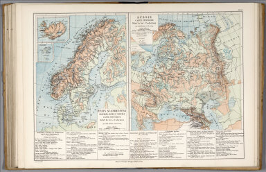
Estats Scandinaves : Danmark, Suede et Norvege : Carte physique : Relief du sol. -- Productions. Echelle 1: 9,400,000. Russie : Carte Physique : Relief du sol. -- Production. echelle 1: 16,320,000. Par M.Mrs. Drioux et Ch. Leroy. Grave par Lamblin. Librairie Classique Eugene Belin Paris. (to accompany) Atlas Universel Et Classique De Geographie ...1886. (insets) Islande ; Is. Foeroe.
List No
3277.044
Note
Two physical maps of Scandinavia and Russia on 2 pages. Shows regions, cities, rivers, lakes, mountains, etc. Relief shown by hachures and spot heights. Depth shown by gradient tints and soundings. Includes elevation table, and notes on production, agriculture, and industry.
Author
[Drioux, Claude-Joseph, Leroy, Charles]
Full Title
Carte politique : Estats Scandinaves : Danmark, Suede et Norvege. Carte politique : Russie. Par M.Mrs. Drioux et Ch. Leroy. Grave par Sonnet. Librairie Classique Eugene Belin Paris. (to accompany) Atlas Universel Et Classique De Geographie ...1886. (insets) Islande ; Is. Foeroe.
List No
3277.045
Note
Two political maps of Scandinavia and Russia on 2 pages. Shows administrative divisions, regions, cities, road, railways, shipping ways, mountains, etc. Relief shown by hachures.
Author
[Bayer, Herbert, Container Corporation of America]
Full Title
U.S.S.R. Europe. (insets) (Vicinity of Leningrad and Moscow).
List No
5842.118
Note
Relief depicted by hachures and hypsometric tints.
Author
[Bayer, Herbert, Container Corporation of America]
Full Title
U.S.S.R. U.S.S.R. Western Asia.
List No
5842.119
Note
Comparisons of U.S.A. and U.S.S.R. economic variables. Map and graphics showing principal resources, population, mineral production, agriculture, and land use. Includes brief history and description of country. Relief depicted by hachures and hypsometric tints. Vicinity maps of Kiev, Odessa, Kherson, Tashkent, Tbilisi, Baku, and Novosibirsk.
Author
McGraw-Hill Book Company
Full Title
Union of Soviet Socialist Republics.
List No
6350.031
Note
Shaded hypsometric relief.
1-49 of 49
|