|
REFINE
Browse All : World Atlas and Physical and Atlas Map of Germany
1-42 of 42
Author
[Sydow, Emil von., 1812-1873, Wagner, Hermann, 1840-1929]
Full Title
Südwest- Deutschland. Gotha : Justus Perthes. Sydow-Wagners method. Schul-Atlas. XXI.
List No
13557.089
Note
Map of Southwestern Germany. Vereinfachte Kegelprojektion.
Author
[Desbuissons, L.E., Migeon, J.]
Full Title
France Physique. Grave par Lecocq. Dresse Sous La Direction De J. Migeon Par Ch. Lacoste. Les Eaux par Fontaine. Ecrit par A. Bizet. (1892). Fillatreau del. and Barbier sc. (for vignette).
List No
0507.017
Note
Full color by watersheds or drainages. Relief shown by hachures. Vignette of Saut du Doubs. Inset of Corsica.
Author
[Desbuissons, L.E., Migeon, J.]
Full Title
France Hypsometrique. Grave par Lecocq. Dresse Sous La Direction De J. Migeon Par Ch. Lacoste. Les Eaux par Fontaine. Ecrit par A. Bizet. (1892). Fillatreau del. and Barbier sc. (for vignette).
List No
0507.018
Note
Full color by elevation. Relief shown by hachures. Vignette of Mont Blanc. Inset of Corsica.
Author
[Ewald, Ludwig 1813-1881, Bauerkeller, Georg Leonhart]
Full Title
No. 32. Deutschland.
List No
12189.054
Author
[Heck, Johann Georg, -1857, Weber, Ph.]
Full Title
Plate 18. Koenigreich Preussen.
List No
12190.256
Author
[Sydow, Emil von., 1812-1873, Wagner, Hermann, 1840-1929]
Full Title
Nordost-Deutschland. Gotha : Justus Perthes. Sydow-Wagners method. Schul-Atlas . XXI.
List No
13557.075
Note
Map of Northeastern Germany, with insets: Breslau; Dresden. Vereinfachte Kegelprojektion.
Author
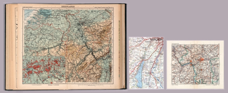
[Sydow, Emil von., 1812-1873, Wagner, Hermann, 1840-1929]
Full Title
Rheinlande. Gotha : Justus Perthes. Sydow-Wagners method. Schul-Atlas. XXI.
List No
13557.078
Note
Map of Rhein region. Vereinfachte Kegelprojektion. Includes 2 insets: Koln, Rheinisch-Westfalisches Industriegeibiet.
Author
[Sydow, Emil von., 1812-1873, Wagner, Hermann, 1840-1929]
Full Title
Mitteldeutschland . Gotha : Justus Perthes. Sydow-Wagners method. Schul-Atlas. XXI.
List No
13557.081
Note
Map of central Germany. Vereinfachte Kegelprojektion.
Author
[Sydow, Emil von., 1812-1873, Wagner, Hermann, 1840-1929]
Full Title
Schlesien und Ostbohmen. Gotha : Justus Perthes. Sydow-Wagners method. Schul-Atlas. XXI.
List No
13557.084
Note
Map of Silesia and Eastern Bohemia, with insets: Oberschlesisches industriegebiet; Prag. Vereinfachte Kegelprojektion.
Author
[Sydow, Emil von., 1812-1873, Wagner, Hermann, 1840-1929]
Full Title
Süddeutschland, Schweiz und Bohmen. Gotha : Justus Perthes. Sydow-Wagners method. Schul-Atlas. XXI.
List No
13557.087
Note
Map of Southern Germany and neighboring counties.
Author
[Sydow, Emil von., 1812-1873, Wagner, Hermann, 1840-1929]
Full Title
Süddeutschland, Schweiz und Bohmen. Gotha : Justus Perthes. Sydow-Wagners method. Schul-Atlas. XXI.
List No
13557.087
Note
Map of Southern Germany and neighboring counties.
Author
[Sydow, Emil von., 1812-1873, Wagner, Hermann, 1840-1929]
Full Title
Nordost-Deutschland. Gotha : Justus Perthes. Sydow-Wagners method. Schul-Atlas . XXII.
List No
13558.069
Note
Map of Northeastern Germany. Vereinfachte Kegelprojektion.
Author
[Sydow, Emil von., 1812-1873, Wagner, Hermann, 1840-1929]
Full Title
Rheinlande. Gotha : Justus Perthes. Sydow-Wagners method. Schul-Atlas. XXII.
List No
13558.072
Note
Map of Rhein region. With inset map: Rheinisch-Westfalisches Industriegeibiet. Vereinfachte Kegelprojektion.
Author
[Sydow, Emil von., 1812-1873, Wagner, Hermann, 1840-1929]
Full Title
Schlesien und Protektorat-Ostteil. Gotha : Justus Perthes. Sydow-Wagners method. Schul-Atlas. XXII.
List No
13558.078
Note
Map of Silesia and Protectorate Eastern Part. With inset: Oberschlesisches industriegebiet. Vereinfachte Kegelprojektion.
Author
[Sydow, Emil von., 1812-1873, Wagner, Hermann, 1840-1929]
Full Title
Süddeutschland, Schweiz, Protektorat. Gotha : Justus Perthes. Sydow-Wagners method. Schul-Atlas. XXII.
List No
13558.081
Note
Map of Southern Germany and neighboring counties. Vereinfachte Kegelprojektion.
Author
[Sydow, Emil von., 1812-1873, Wagner, Hermann, 1840-1929]
Full Title
Südwest- Deutschland. Gotha : Justus Perthes. Sydow-Wagners method. Schul-Atlas. XXII.
List No
13558.084
Note
Map of Southwestern Germany. Vereinfachte Kegelprojektion.
Author
[Sydow, Emil von., 1812-1873, Wagner, Hermann, 1840-1929]
Full Title
Nordost-Deutschland. Gotha : Justus Perthes. Sydow-Wagners method. Schul-Atlas . XXIII.
List No
13559.069
Note
Map of Northeastern Germany. Vereinfachte Kegelprojektion.
Author
[Sydow, Emil von., 1812-1873, Wagner, Hermann, 1840-1929]
Full Title
Rheinlande. Gotha : Justus Perthes. Sydow-Wagners method. Schul-Atlas. XXIII.
List No
13559.072
Note
Map of Rhein region. With inset map: Rheinisch-Westfalisches Industriegeibiet. Vereinfachte Kegelprojektion. Map is accompanied by newspaper clippings of 3 cities: Frankfut and Munchen.
Author
[Sydow, Emil von., 1812-1873, Wagner, Hermann, 1840-1929]
Full Title
Schlesien und Protektorat-Ostteil. Gotha : Justus Perthes. Sydow-Wagners method. Schul-Atlas. XXIII.
List No
13559.079
Note
Map of Silesia and Protectorate Eastern Part. With inset: Oberschlesisches industriegebiet. Vereinfachte Kegelprojektion.
Author
[Sydow, Emil von., 1812-1873, Wagner, Hermann, 1840-1929]
Full Title
Süddeutschland, Schweiz, Protektorat. Gotha : Justus Perthes. Sydow-Wagners method. Schul-Atlas. XXIII.
List No
13559.082
Note
Map of Southern Germany and neighboring counties. Vereinfachte Kegelprojektion.
Author
[Sydow, Emil von., 1812-1873, Wagner, Hermann, 1840-1929]
Full Title
Südwest- Deutschland. Gotha : Justus Perthes. Sydow-Wagners method. Schul-Atlas. XXIII.
List No
13559.085
Note
Map of Southwestern Germany. Vereinfachte Kegelprojektion.
Author
Brue, Adrien Hubert, 1786-1832
Full Title
Carte d'Allemagne, comprenant la Confederation Germanique. Dressee par le Chev. Lapie ... A Paris : chez Basset... 1821. Grave par Chamouin. Ecrit par Lallemand. (to accompany) Atlas physique et politique des cinq parties du monde, par H. Brue.
List No
13565.024
Note
Outline hand color engraved map of Germany. Includes index.
Author
[Baranov, Anatolij Nikolaevič, Soviet Union. Glavnoe upravlenie geodezii i kartografii]
Full Title
Центральная Европа = TSentral'naia Evropa. 118-119. Atlas Mira : 1954.
List No
13682.132
Note
Physical and political map of Central Europe. Showing political boundaries. Relief shown by gradient tints, contours and spot heights. Depth shown by bathymetric tints, isolines and soundings.
Author
[Baranov, Anatolij Nikolaevič, Soviet Union. Glavnoe upravlenie geodezii i kartografii]
Full Title
Германия (Север) = Germaniia (Sever). 121-122. Atlas Mira : 1954.
List No
13682.135
Note
Physical map of Northern Germany. Showing political boundaries and major cities. Relief shown by gradient tints, contours and spot heights. Depth shown by bathymetric tints, isolines and soundings.
Author
[Baranov, Anatolij Nikolaevič, Soviet Union. Glavnoe upravlenie geodezii i kartografii]
Full Title
Германия (Юг) = Germaniia (Iug). 124. Atlas Mira : 1954.
List No
13682.137
Note
Physical map of Southern Germany. Showing administrative divisions, cities, roads, railroads, rivers, canals and lakes. Relief shown by gradient tints, contours and spot heights. Depth shown by soundings.
Author
[Baranov, Anatolij Nikolaevič, Soviet Union. Glavnoe upravlenie geodezii i kartografii]
Full Title
Придунайские Страны = Pridunayskie Strany. 129-130. Atlas Mira : 1954.
List No
13682.143
Note
Physical and political map of Danube River Region from its sources in the Alps to the Black Sea. Showing political and administrative boundaries. Relief shown by gradient tints, contours and spot heights. Depth shown by bathymetric tints, isolines and soundings.
Full Title
Deutschland physikalisch. (Richard Andree. Herausgegeben von der Geographischen Anstalt von Velhagen & Klasing in Leipzig. 1881)
List No
1494.014
Note
Colored map. Relief shown by hachures, spot heights and altitude tints. Shows rivers, lakes, canals, cities, etc. "X.1880."
Full Title
Hohenschichtenkarte von Deutschland. Bevolkerungsdichtigkeit von Deutschland. (Richard Andree. Herausgegeben von der Geographischen Anstalt von Velhagen & Klasing in Leipzig. 1881)
List No
1494.018
Note
Two colored maps. Relief shown by altitude tints and spot heights.
Author
USSR (Union of Soviet Socialist Republics).
Full Title
67-68. North-East France, Belgium, Luxemburg. The World Atlas.
List No
1603.079
Author
USSR (Union of Soviet Socialist Republics).
Full Title
79-80. Europe, Central. The World Atlas.
List No
1603.091
Author
USSR (Union of Soviet Socialist Republics).
Full Title
82-83. Federal Republic of Germany (West Germany). The World Atlas.
List No
1603.094
Note
Vicinity maps of cities.
Author
[Instituto Geographico di Agostini, Bayer, Herbert]
Full Title
Europa Centrale. (insets) Varsavia, and Praha (Prague).
List No
2170.046
Note
Relief shown as combined hachures, shaded relief, and hypsometric tints.
Author
[Sonnenschein, W. Swan, Allen, Bevan, G.P.]
Full Title
Germany. W. Swan Sonnenschein & Allen's Plastic School Atlas.
List No
2490.034
Note
Raised relief. List of Provinces of Prussia keyed to map.
Author
[Sonnenschein, W. Swan, Allen, Bevan, G.P.]
Full Title
Germany. W. Swan Sonnenschein & Allen's Plastic School Atlas.
List No
2490.035
Note
Image rescanned with directional lighting to highlight raised relief. List of Provinces of Prussia keyed to map.
Author
[Drioux, Claude-Joseph, Leroy, Charles]
Full Title
Carte physique de l'Europe Centrale : Allemagne et Prusse : Autriche - Hongrie : Relief du so -- Productions. Par M.Mrs. Drioux et Ch. Leroy. Dessine par Eug. Letot -- Grave par P. Mea. Librairie Classique Eugene Belin Paris. (to accompany) Atlas Universel Et Classique De Geographie ...1886.
List No
3277.039
Note
Color maps on 2 pages. Shows railways, canals and forests. also shows regions, cities, roads, cities, etc. Relief shown by Gradient tints, hachures and spot heights. Includes notes on production, agriculture, and industry, and elevation table.
Author
Dussieux, L.
Full Title
79. Carte Physique (Oro-Hydrographique) de l'Allemagne.
List No
4759.077
Author
Stieler, Adolf
Full Title
No. XXIV. Stieler's Hand-Atlas (No. 18.) Fluss u. Berg-Karte von Deutschland. (River and Mountain Map of Germany).
List No
4973.065
Note
Revision of 1820 edition.
Author
[Bayer, Herbert, Container Corporation of America]
Full Title
Central Europe.
List No
5842.106
Note
Map and graphics showing principal resources, population, occupations, manufacturing, mineral production, agriculture, and land use. Includes brief history and description of state's features. Relief depicted by hachures and hypsometric tints.
Author
[Bayer, Herbert, Container Corporation of America]
Full Title
Southern Central Europe. (insets) (Vicinity of Bern, Basel, Zurich, Trieste Free Territory, and Budapest).
List No
5842.108
Note
Relief depicted by hachures and hypsometric tints.
Author
Stieler, Adolf
Full Title
Fluss- und Berg-Karte von Deutschland und den anliegenden Landern; entw. u. gez. v. Ad. St. 1820. Hasse sc. (upper right margin) Hand-Atl. No. 18. (to accompany) Hand-Atlas uber alle Theile der Erde, nach dem neuesten Zustande und uber das Weltgebaude.
List No
6830.030
Note
Engraved outline hand color map. Relief shown by hachures.
Author
[Ravenstein, August, Dondorf, B.]
Full Title
Allemagne Les royaumes de Neerlande et de Belgique Confederation Suisse. Dessine et modele par Aug. Ravenstein a Francfort s/M. Grave. imprime et estampe par B. Dondorf a Francfort s/M.
List No
8268.017
Note
3D raised relief map of Germany, Netherlands, Belgium and Switzerland. Shows political divisions, major cities and towns. Includes statistical tables, abbreviations, and notes. Prime meridian is Paris.
Author
[Geographisches Institut (Weimar, Germany), Graef, Adolf]
Full Title
Deutschland nach seinen Oro-Hydrographschen Verhaeltnissen. (Germany: Topography and Hydrography.)
List No
9679.014
1-42 of 42
|