|
Author
Arrowsmith, John, 1790-1873
Full Title
The world, on Mercator's projection, by John Arrowsmith. London, pubd. Augt. 22nd. 1861, by J. Arrowsmith, 10 Soho Square.
List No
14506.008
Note
Composite world map. Shows countries, regions and cities, topography, bodies of water, drainage, deserts, coastlines and islands. Relief shown with hachures. Features exploration routes with names of explorers and dates of their voyages. Includes latitudinal and longitudinal lines. Descriptive notes throughout. With two inset maps: [South Pole] -- [North Pole]. Hand-colored engraving. All together, map is 64 x 109 cm, on two double sheets, together 68 x 112 cm.
Author
Arrowsmith, John, 1790-1873
Full Title
Official map of railways in England and Scotland, shewing the existing lines & those in progress; from the maps prepared, by the authority of the Commissioners of Railways; (presented to both houses of parliament) and from the other documents; by John Arrowsmith. 1858. London, pubd. July 1st, 1858, by J. Arrowsmith, 10 Soho Square.
List No
14506.014
Note
Composite map of railways in England and Scotland. Shows counties, cities, railways, bodies of water, drainage, coastlines and islands. Relief shown with hachures. Includes a legend, latitudinal and longitudinal lines, as well as a bar scale given in English miles. Hand-colored engraving. Hand-colored engraving. All together, map is 106 x 67 cm, on two double sheets, together 68 x 112 cm.
Author
Arrowsmith, John, 1790-1873
Full Title
(Composite map of) Map of the West coast of Africa comprising Guinea, and the British possessions at Sierra Leone, on the Gambia and the Gold Coast, together with the countries within the courses of the rivers Senegal, Gambia & Kowara, compiled from official documents, by J. Arrowsmith, 1858. London. Pubd. 17th April 1858, by John Arrowsmith, 10 Soho Square.
List No
14506.042
Note
Composite map representing West Africa. Shows political boundaries, cities, roads, topography, deserts, bodies of water, drainage, coastlines, and islands. Relief shown with hachures. Includes latitudinal and longitudinal lines. Hand-colored engraving.
Author
[Arrowsmith, John, 1790-1873, Murchison, Roderick Impey, Sir, 1792-1871, Yule, Henry, Sir, 1820-1889]
Full Title
(Composite map of) This new map of Burma and the regions adjacent; is inscribed to Sir Roderick Murchison, P.R.G.S. &c. &c. &c. By H. Yule, Captn. Bengal Engrs. London, 1857. John Arrowsmith.
List No
14506.063
Note
Composite map representing current-day Myanmar and part of Thailand. Shows political boundaries, cities, roads, topography, bodies of water, drainage, coastlines, and islands. Relief shown with hachures. Includes a glossary and informational text, as well as latitudinal and longitudinal lines, as well as a bar scale given in English miles. Hand-colored engraving.
Author
[Arrowsmith, John, 1790-1873, Pemberton, J. Despard (Joseph Despard), 1821-1893]
Full Title
(Composite map of) The South Eastern districts of Vancouver Island, from a trigonometrical survey made by order of the honble hudsons bay company. by J. D. Pemberton, Engr. & Survr. to the Company. London, Published 2d. Octr. 1855 by John Arrowsmith, 10 Soho Square.
List No
14506.105
Note
Map representing the Southeastern part of Vancouver Island, Canada. Shows property ownership, cities, roads, topography, bodies of water, drainage, coastlines, and islands. Relief shown with hachures. Includes informational text, latitudinal and longitudinal lines, as well as bar scales given in chains and English miles. With ancillary map: [Gulf of Georgia]. Hand-colored engraving. Map is 43 x 64 cm, on double sheet 56 x 68 cm.
Author
Arrowsmith, John, 1790-1873
Full Title
(Composite map of) Map of the Eastern townships of lower Canada, drawn principally from actual survey for the British American Land Company, by A. Wells. Provincial Land Survr. Dedicated to the Govenor, deputy Governor & Court of Directors of the above company. By John Arrowsmith. London, Published May 22d. 1842, by J.Arrowsmith, 10 Soho Square.
List No
14506.113
Note
Composite map representing the Southeastern part of Québec, Canada. Shows political boundaries, cities, roads, topography, bodies of water, and drainage. Relief shown with hachures. Includes a legend, informational text, latitudinal and longitudinal lines, as well as bar scales given in English miles and French leagues.
Author
[Depot General de la Marine, Beautemps-Beaupré, Charles François, 1766-1854]
Full Title
(Composite map of) (North and South Sheets) Carte Particuliere Des Cotes De France (Embouchure De La Loire)
List No
15934.148
Note
Hydrographie Française 4
Author
Depot General de la Marine
Full Title
(Composite map to) Reconnoissance Hydrographique De La Cote Nord De France (Rade De Dunkerque Et Ses Environs) (West and East Sheets)
List No
15934.100
Note
Hydrographie Française 3
Author
[Depot General de la Marine, MacKenzie, Murdoch]
Full Title
(Composite map of) Carte Des Rades De Ste Helene Et Spithead (and) Carte De Selsea-Bill
List No
15934.060
Note
Hydrographie Française 2
Author
Depot General de la Marine
Full Title
(Composite map of) (North and South Sheets) Carte Reduite De La Mer Du Nord.
List No
15934.006
Note
Hydrographie Française 1
Author
Depot General de la Marine
Full Title
Carte Reduite De La Mer Baltique VI e Feuille Contenant Le Golfe De Finlande
List No
15934.033
Note
Hydrographie Française 1
Author
[Depot General de la Marine, Beautemps Beaupré, Charles François]
Full Title
(Composite map of) (Sheets 1 - 2) Carte Reduite Des Cotes Des Pays-Bas (depuis Ostende jusqu'a Hellevoetsluis)
List No
15934.040
Note
Hydrographie Française 1
Author
Depot General de la Marine
Full Title
(Composite map of) (Sheets 1 - 3) Reconnoissance Du Cours Du Hont ou Wester Schelde (Escault Occidental) depuis Antwerpen (Anvers) jusqu'a l'Embouchure
List No
15934.044
Note
Hydrographie Française 1
Author
Andriveau-Goujon, Eugene
Full Title
(Composite Map) Carte orographique, hydrographique et routiere de L'empire Francais : comprenant le bassin du Rhin et la region des Alpes occidentales, d'apres les etats-majors Francais et etrangers. Publee par E. Andriveau-Goujon. Rue du Bac. 21. Paris. 1861. Dressee et dessinee par A. Vuillemin. Le chemins de fer par Alfred Potiquet. Grave par Acier, le trait par Smith; la topographie par Gerin; les Ecritures par P. Rousset. Les Eaux par Fontaine. (to accompany) Atlas classique et universel de geograparphie ancienne et moderne ... Nouvelle edition. 1863.
List No
13421.034
Note
Composite map: 1 hand color map on 4 sheets
Author
Andriveau-Goujon, Eugene
Full Title
(Composite Map) Asie Orientale comprenant L'Empire Chinois et le Japon, les Etats de L'Indo-Chine et le Grand Archipel d'Asie. (to accompany) Atlas classique et universel de geograparphie ancienne et moderne ... Nouvelle edition. 1863.
List No
13421.051
Note
Composite map of sheets 38-39: Asie Orientale.
Author
Andriveau-Goujon, Eugene
Full Title
(Composite Map) Algerie, d'apres les cartes de l'Etat-major et les documents du Ministere de la Guerre. E. Andriveau-Goujon, Editeur. Paris, Rue du Bac. 21.1862. Paris, Impie. de Louis Antoine. Gravee par Ms. Gerin, Dalmont, Smith et Fontaine. (to accompany) Atlas classique et universel de geograparphie ancienne et moderne ... Nouvelle edition. 1863.
List No
13421.057
Note
Composite map of sheets 43-44: Algerie.
Author
Andriveau-Goujon, Eugene
Full Title
(Composite Map) Carte Generale des Etats - Unis et du Mexique : Comprenant L'Amerique Centrale Et Les Antilles. E. Andriveau-Goujon, Editeur. Paris, Rue Du Bac, 21. 1862. (to accompany) Atlas classique et universel de geograparphie ancienne et moderne ... Nouvelle edition. 1863.
List No
13421.062
Note
Composite map of sheets 47-48: Etats - Unis et du Mexique.
Author
Hoffmann, Johann
Full Title
(Composite map of) 52 images of "Europaelsch-Geographlsche Spiel-charte"
List No
15665.016
Note
This is a composite image of 52 reproductions of the "Europaelsch-Geographlsche Spiel-charte" from the collection of the National Library of Norway https://www.nb.no/en/
Author
Cram, George Franklin, 1841-1928
Full Title
(Composite Map to) New York : Western half. -- New York : Eastern half. 1899, by Geo. F. Cram.
List No
14372.022
Note
Composite map of New York (western and eastern halves). Shows political boundaries, counties, towns, railroads, steamship lines, topography, bodies of water, drainage, coastlines and islands. Relief shown with hachures. Includes keys with explanations, latitudinal and longitudinal lines, as well as bar scales given in miles. With alphanumeric grid corresponding to "Index of New York" on pages 27-29, 32-35, 38-41 and 44. Colored lithograph. Together, maps are 56 x 80 cm, on two double sheets 67 x 90 cm. "Index of maps" and "Index of cities" in margins, providing navigation for atlas as a whole.
Author
Cram, George Franklin, 1841-1928
Full Title
(Composite Map to) Western half of Pennsylvania. -- Eastern half of Pennsylvania. 1899, by Geo. F. Cram.
List No
14372.036
Note
Composite map of Pennsylvania (western and eastern halves). Shows political boundaries, counties, towns, railroads, steamship lines, topography, bodies of water, drainage, coastlines and islands. Relief shown with hachures. Includes keys with explanations, latitudinal and longitudinal lines, as well as bar scales given in miles. With alphanumeric grid corresponding to "Index of Pennsylvania" on pages 45-55, 58-61 and 64-67. Colored lithograph. Together, maps are 54 x 85 cm, on two double sheets 67 x 90 cm. "Index of maps" and "Index of cities" in margins, providing navigation for atlas as a whole.
Author
Cram, George Franklin, 1841-1928
Full Title
(Composite Map to) Western half of Virginia and West Virginia. -- Eastern half of Virginia and West Virginia. 1899, by Geo. F. Cram.
List No
14372.056
Note
Composite map of Virginia and West Virginia (western and eastern halves). Shows political boundaries, counties, towns, railroads, steamship lines, topography, bodies of water, drainage, coastlines and islands. Relief shown with hachures. Includes keys with explanations, latitudinal and longitudinal lines, as well as bar scales given in miles. With alphanumeric grid corresponding to "Index of Virginia" on pages 85-93 and 96-98, and "Index of West Virginia" on pages 99, 102-105 and 108-110. Colored lithograph. Together, maps are 55 x 85 cm, on two double sheets 67 x 90 cm. "Index of maps" and "Index of cities" in margins, providing navigation for atlas as a whole.
Author
Cram, George Franklin, 1841-1928
Full Title
(Composite Map to) Ohio : North half. -- Ohio : [South half]. 1899, by Geo. F. Cram.
List No
14372.067
Note
Composite map of Ohio (northern and southern halves). Shows political boundaries, counties, towns, railroads, steamship lines, topography, bodies of water, drainage, coastlines and islands. Relief shown with hachures. Includes keys with explanations, latitudinal and longitudinal lines, as well as bar scales given in miles. With alphanumeric grid corresponding to "Index of Ohio" on pages 111-113, 116-119, 122-125 and 128. Colored lithograph. Together, maps are 80 x 55 cm, on two double sheets 90 x 67 cm. "Index of maps" and "Index of cities" in margins, providing navigation for atlas as a whole.
Author
Cram, George Franklin, 1841-1928
Full Title
(Composite Map to) Western half of Texas. -- Eastern half of Texas. 1899, by Geo. F. Cram.
List No
14372.187
Note
Composite map of Texas (western and eastern halves). Shows political boundaries, counties, towns, railroads, steamship lines, topography, bodies of water, drainage, coastlines and islands. Relief shown with hachures. Includes keys with explanations, latitudinal and longitudinal lines, as well as bar scales given in miles. With alphanumeric grid corresponding to "Index of Texas" on pages 341, 344-347, 350-353 and 356. Colored lithograph. Together, map is 57 x 81 cm, on two double sheets 67 x 90 cm. "Index of maps" and "Index of cities" in margins, providing navigation for atlas as a whole.
Author
Cram, George Franklin, 1841-1928
Full Title
(Composite Map to) California and Nevada : Northern half. -- California and Nevada : Southern half. 1899, by Geo. F. Cram.
List No
14372.205
Note
Composite map of California and Nevada (northern and southern halves). Shows political boundaries, counties, towns, railroads, topography, bodies of water, drainage, coastlines and islands. Relief shown with hachures. Includes keys with explanations, latitudinal and longitudinal lines, as well as bar scales given in miles. With alphanumeric grid corresponding to "Index of Nevada" on page 371; "Index of California" on pages 374-375, 378-379 and 382. Colored lithograph. Together, maps are 82 x 57 cm, on two double sheets 90 x 67 cm. "Index of maps" and "Index of cities" in margins, providing navigation for atlas as a whole.
Author
Cram, George Franklin, 1841-1928
Full Title
(Composite Map to) Western part of Washington. -- Eastern part of Washington. 1899, by Geo. F. Cram.
List No
14372.223
Note
Composite map of Washington (western and eastern halves). Shows political boundaries, counties, towns, Indian reservations, mines, railroads, topography, bodies of water, drainage, coastlines and islands. Relief shown with hachures. Includes keys with explanations, latitudinal and longitudinal lines, as well as bar scales given in miles. With alphanumeric grid corresponding to "Index of Washington" on pages 403 and 406-407. Colored lithograph. Together, map is 55 x 80 cm, on two double sheets 67 x 90 cm. "Index of maps" and "Index of cities" in margins, providing navigation for atlas as a whole.
Author
Cram, George Franklin, 1841-1928
Full Title
(Composite Map to) Western half of Nova Scotia. -- Eastern half of Nova Scotia. 1899, by Geo. F. Cram.
List No
14372.247
Note
Composite map of Nova Scotia, Canada (western and eastern halves). Shows political boundaries, counties, towns, railroads, topography, bodies of water, drainage, coastlines and islands. Relief shown with hachures. Includes keys with explanations, latitudinal and longitudinal lines, as well as bar scales given in miles. With alphanumeric grid corresponding to "Index of Nova Scotia" on pages 435 and 438-439. Colored lithograph. Together, map is 55 x 80 cm, on double sheet 67 x 90 cm. "Index of maps" and "Index of cities" in margins, providing navigation for atlas as a whole.
Author
Andriveau-Goujon, E. (Eugène), 1832-1897
Full Title
(Composite to) Carte orographique hydrographique et routière de la France comprenant le Bassin du Rhin et la Région des Alpes occidentales réduite de la nouvelle carte de France de l'État-Major dressée au Dépôt de la Guerre. Publiée par E. Andriveau-Goujon, Rue du Bac, 4, Paris, 1881. Gravé sur Acier; le trait par Smith; la topographie par Gérin; les ecritures par P. Rousset; les eaux par Fontaine; Impie. Alfred Chardon Jne.
List No
14008.013
Note
Hand-colored, engraved fold-out map of France, showing political boundaries, roads and railroads (on double plate with decorative border, on two consecutive sheets: 8 and 9). Includes legend, as well as 3 bar scales and a scale statement. With inset: (Bouches de Bonifacio).
Author
Philip, George, 1870-1937.
Full Title
(Composite map to) North West and South West Germany.
List No
15487.043
Author
Philip, George, 1870-1937.
Full Title
(Composite map to) Canada (East and West Sheets)
List No
15487.115
Author
Philip, George, 1870-1937.
Full Title
(Composite map to) South America (Northern and Southern Sheets).
List No
15487.141
Author
[Elwe, Jan Barend, L'Isle, Guillaume de, 1675-1726]
Full Title
(Composite Map to) Carte des Courones du Nord. Dediée au tres Puissant et tres Invincible Prince Charles XII Roy de Suede, des Gots et des Vandales Grand Duc de Finlande &c. Par son tres humble et tres obeisant serviteur Guillaume del'Isle de l'Academie Rle. des Sciences a Amsterdam Chéz Jan Bt. Elwe. MDCCXCII.
List No
14478.033
Note
Composite map of Scandinavia and vicinity, featuring Norway Sweden and Finland. Shows countries, regions, cities, topography, vegetation, bodies of water, drainage, coastlines and islands. Relief shown pictorially. Includes compass roses with north oriented toward top of sheet, four bar scales, latitudinal and longitudinal lines. With a decorative cartouche. Hand-colored engraving. Composite map is 91 x 60 cm, on two double sheets, together 116 x 70 cm.
Author
[Elwe, Jan Barend, L'Isle, Guillaume de, 1675-1726]
Full Title
(Composite Map to) Partie meridionale de Moscovie dressée par G. de L'Isle rectisié & augmente. Chez Jan Barend Elwe. A Amsterdam. -- Cartie nouvelle de Moscovie represente la partie septenntrionale dressée par G. de L'Isle rectisié & augmente. A Amsterdam. Chés Jan B. Elwe. MDCCXCII.
List No
14478.038
Note
Composite map of the Moscow Region, Russia. Shows regions, cities, railways, topography, vegetation, bodies of water, drainage, shorelines, coastlines and islands. Relief shown pictorially. Includes a compass rose with north oriented toward top of sheet, three bar scales, latitudinal and longitudinal lines, and descriptive notes throughout.. With decorative cartouches. Hand-colored engraving. Composite map is 80 x 55 cm, on two double sheets, together 116 x 70 cm.
Author
Elwe, Jan Barend
Full Title
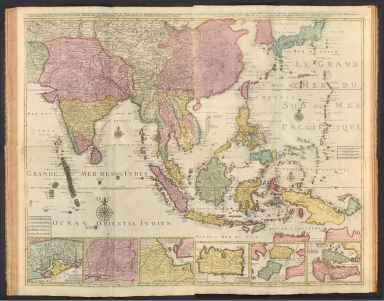
(Composite Map to) 1 Partie de la nouvelle grande carte des Indes Orientales, contenant les Terres du Mogol, Surate, Malabar, Cormandel, Bengale, Aracan, Pegu, Siam, Camboje, Tonquin, & une partie de la Chine -- 2 Partie de la nouvelle grande carte des Indes Orientales, contenant les Empires de la Chine & du Japon, les Isles Philippines, Couchin, & les Isles Marianes -- 3 Partie de la nouvelle grande carte des Indes Orientales, contenant les Isles Maldives, Ceyi, An, Malacca, Sumatra &c. avec les terres adjacentes de Couchin, Negombo, Colombo & Sourabaia -- 4 Partie de la nouvelle grande carte des Indes Orientales, contenant les Isles de Borneo, Java, Celebes, Mindanao, Gilolo, Molucques, La Nouvelle Guinée, La Nouvelle Bretagne, & les Nouvelles Philippines; avec les Isles de Sumbawa, Serbira, Solor, Bouton & Pangesane dressée avec soin, sur pluseurs cartes manuscrites, par un habile connoisseur; & publiée a Amsterdam par Jan Bt. Elwe. MDCCXCII.
List No
14478.048
Note
Composite map of Asia, including the Mughal Empire [current-day India, Pakistan and Afghanistan], the Malabar, Coromandel, Bengal and Aracan regions, Siam [current-day Thailand], Camdodia, Tonquin [current-day Vietnam], China, Japan, the Philippines, the Mariana Islands, Maldives, Ceylon [current-day Sri Lanka], Malaysia, Sumatra (Indonesia), Borneo, Java, Celebes [Sulawesi], Gilolo [Halmahera], the Maluku Islands (Indonesia), Mindanao (Philippines) and Papua New Guinea. Shows countries, regions, cities, topography, vegetation, bodies of water, drainage, coastlines and islands. Relief shown pictorially. Includes compass roses with north oriented toward top of sheet, bar scales, latitudinal and longitudinal lines, and descriptive notes throughout. Inset maps: Carte de Royaume de Couchin de Coilan et de Cranganor -- Carte de Nigombo, Colombo -- Carte de Princepaute de Soerabaye et Terre de Grissik -- Isle de Sumbawa -- Isles de Serbira et de Solor -- Isles de Bouton et Pangesane. Hand-colored engraving. Composite map is 98 x 118 cm, on four double sheets, together 116 x 140 cm.
Author
[U.S. Coast and Geodetic Survey, U.S. Army Air Forces]
Full Title
Composite North Pole 6 Sheets World Aeronautical Charts Polar Sterographic Projection.
List No
15328.046
Author
[U.S. Coast and Geodetic Survey, U.S. Army Air Forces]
Full Title
Composite 43 World Aeronautical Charts. Robinson Projection.
List No
15328.050
Author
[U.S. Coast and Geodetic Survey, U.S. Army Air Forces]
Full Title
Composite South Pole 6 Sheets World Aeronautical Charts UPS South (Universal Polar Sterographic).
List No
15328.047
Author
[U.S. Coast and Geodetic Survey, U.S. Army Air Forces]
Full Title
Composite 43 World Aeronautical Charts. Mollweide Projection.
List No
15328.049
Author
[U.S. Coast and Geodetic Survey, U.S. Army Air Forces]
Full Title
Composite 43 World Aeronautical Charts. Geographic Projection.
List No
15328.045
Author
Monte (Monti), Urbano, 1544-1613
Full Title
(Composite map of) Tavola 1-60. (Map of the World) (with additional spheres and labels in the four corners).
List No
10130.087
Note
Composite map of the first ring of four sheets around the north pole, the second ring of 8 sheets, the third ring of 12 sheets, the fourth ring of 18 sheets, the fifth ring of 18 sheets, and the legends and diagrams in the four corners.
Author
Monte (Monti), Urbano, 1544-1613
Full Title
(Composite map of) Tavola 1-4. (Map of the World)
List No
10130.077
Note
Composite map of the first ring of four sheets around the north pole.
Author
Monte (Monti), Urbano, 1544-1613
Full Title
(Composite map of) Tavola 1-12. (Map of the World)
List No
10130.079
Note
Composite map of the first ring of four sheets around the north pole and the second ring of 8 sheets.
Author
Monte (Monti), Urbano, 1544-1613
Full Title
(Composite map of) Tavola 1-24. (Map of the World)
List No
10130.081
Note
Composite map of the first ring of four sheets around the north pole, the second ring of 8 sheets, and the third ring of 12 sheets.
Author
Monte (Monti), Urbano, 1544-1613
Full Title
(Composite map of) Tavola 1-42. (Map of the World)
List No
10130.083
Note
Composite map of the first ring of four sheets around the north pole, the second ring of 8 sheets, the third ring of 12 sheets, and the fourth ring of 18 sheets.
Author
Monte (Monti), Urbano, 1544-1613
Full Title
(Composite map of) Tavola 1-60. (Map of the World)
List No
10130.085
Note
Composite map of the first ring of four sheets around the north pole, the second ring of 8 sheets, the third ring of 12 sheets, the fourth ring of 18 sheets, and the fifth ring of 18 sheets.
Author
Monte (Monti), Urbano, 1544-1613
Full Title
(Composite map of) Tavola 1-60. (Map of the World) (Re-projected in Pseudocylindrical used by Abraham Ortelius, 1570)
List No
10130.091
Note
Re-projected in Pseudocylindrical used by Abraham Ortelius, 1570, simulated here with a Robinson projection. Composite map of the first ring of four sheets around the north pole, the second ring of 8 sheets, the third ring of 12 sheets, the fourth ring of 18 sheets, and the fifth ring of 18 sheets.
Author
Monte (Monti), Urbano, 1544-1613
Full Title
(Composite map of) Tavola 1-60. (Map of the World) (Re-projected in Mercator used by Gerardus Mercator, 1569)
List No
10130.092
Note
Re-projected in Mercator used by Gerardus Mercator, 1569. Composite map of the first ring of four sheets around the north pole, the second ring of 8 sheets, the third ring of 12 sheets, the fourth ring of 18 sheets, and the fifth ring of 18 sheets.
Author
Monte (Monti), Urbano, 1544-1613
Full Title
(Composite map of) Tavola 1-60. (Map of the World) (Re-projected in Plate Carree or Geographic, Marinus of Tyre, Ptolemy)
List No
10130.093
Note
Re-projected in Plate Carree or Geographic, Marinus of Tyre, Ptolemy. Composite map of the first ring of four sheets around the north pole, the second ring of 8 sheets, the third ring of 12 sheets, the fourth ring of 18 sheets, and the fifth ring of 18 sheets.
Author
Monte (Monti), Urbano, 1544-1613
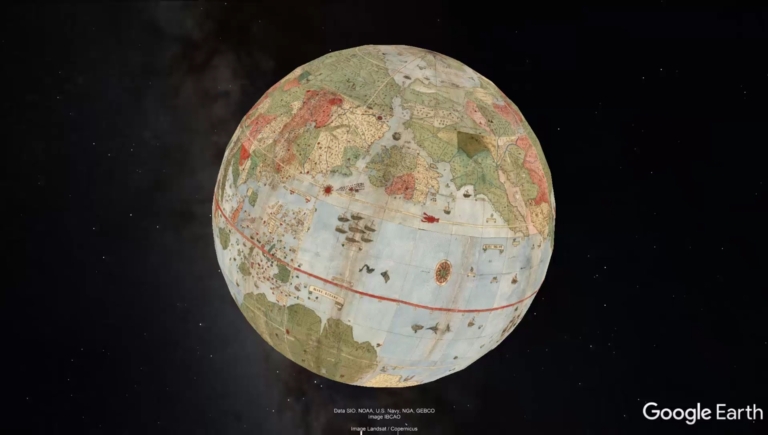
Full Title
(Composite map of) Tavola 1-60. (Map of the World) (In Google Earth)
List No
10130.094
Note
In Google Earth. Composite map of the first ring of four sheets around the north pole, the second ring of 8 sheets, the third ring of 12 sheets, the fourth ring of 18 sheets, and the fifth ring of 18 sheets.
Author
Faden, William, 1749-1836
Full Title
(Composite Map to) Western New World or Hemisphere. 3d. Edition. Engrav'd by Willm. Faden. London publish'd according to Act of Parliament, 28th October, 1790 by William Faden, Geographer to the King, Charing Cross. -- Eastern Old World or Hemisphere. 3d. Edition. Engrav'd by Willm. Faden. London publish'd according to Act of Parliament, Decr. 1st. 1790 by William Faden, Geographer to the King, Charing Cross.
List No
14383.006
Note
Composite map of the Western and Eastern Hemispheres, or "New World" and "Old World" as of 1790, in circular format. Third editions. Maps show continental boundaries, cities, topography, bodies of water, drainage, coastlines, islands and field ice. Maps feature routes of exploration, with explorer names and dates of voyages, such as, "Cooks track 1773" and "Cooks track 1774". Relief shown pictorially. Includes latitudinal and longitudinal lines. Hand-colored engraving. Together, maps are 34 x 70 cm, on double sheet 55 x 76 cm. With stamp: Liverpool Library.
Author
Faden, William, 1749-1836
Full Title
(Composite Map to) Northern Hemisphere. Engrav'd by Willm. Faden. London publish'd according to Act of Parliament, Decr. 1st. 1790 by William Faden, Geographer to the King, Charing Cross. -- Southern Hemisphere. Engrav'd by Willm. Faden. London publish'd according to Act of Parliament, Jany. 1, 1790 by William Faden, Geographer to the King, Charing Cross.
List No
14383.009
Note
Composite map of the Northern and Southern Hemispheres as of 1790, in circular format. Maps show continental boundaries, cities, topography, bodies of water, drainage, coastlines, islands and field ice. Maps feature routes of exploration, with explorer names and dates of voyages, such as, Cooks track to America in 1778" and "Cooks track 1773". Relief shown pictorially. Includes latitudinal and longitudinal lines. Hand-colored engraving. Together, maps are 34 x 70 cm, on double sheet 55 x 76 cm. Each map with stamp: Liverpool Library.
|


![Composite Map: Ohio : North half. -- Ohio : [South half].](https://www.davidrumsey.com/rumsey/Size2/RUMSEY~8~1/205/14372067.jpg)