|
Author
Arrowsmith, John, 1790-1873
Full Title
(Covers to) The London atlas, 1861.
List No
14506.001
Note
Covers to The London atlas of universal geography. Bound in black leather with gilt title, border, and spine title.
Author
Arrowsmith, John, 1790-1873
Full Title
(Title Page to) The London atlas of universal geography, exhibiting the physical & political divisions of the various countries of the world, constructed from original materials. Is most respectfully dedicated to his venerable friends John Middleton Esqr. as a testimony of gratitude and esteem, by his much obliged & humble servant, John Arrowsmith, F.R.G.S. & R.A.S. 10, Soho Square, London. London, pubd. by J. Arrowsmith, 10 Soho Square, 1858.
List No
14506.002
Note
Title page to The London atlas of universal geography.
Author
Arrowsmith, John, 1790-1873
Full Title
(Contents to) Contents.
List No
14506.003
Note
Manuscript table of contents to The London atlas of universal geography. Lists maps by title with associated plate numbers.
Author
Arrowsmith, John, 1790-1873
Full Title
The world, on Mercator's projection, by John Arrowsmith. London, pubd. Augt. 22nd. 1861, by J. Arrowsmith, 10 Soho Square.
List No
14506.008
Note
Composite world map. Shows countries, regions and cities, topography, bodies of water, drainage, deserts, coastlines and islands. Relief shown with hachures. Features exploration routes with names of explorers and dates of their voyages. Includes latitudinal and longitudinal lines. Descriptive notes throughout. With two inset maps: [South Pole] -- [North Pole]. Hand-colored engraving. All together, map is 64 x 109 cm, on two double sheets, together 68 x 112 cm.
Author
Arrowsmith, John, 1790-1873
Full Title
The inland navigation, rail roads, geology, and minerlas of England & Wales, by J. Arrowsmith. London, pubd. 15 Feby. 1842, by J. Arrowsmith, 10 Soho Square.
List No
14506.011
Note
Map representing England and Wales. Shows counties, cities, railways, topography, bodies of water, drainage, coastlines and islands. Relief shown with hachures. Includes a legend, table of geological groups, lines of navigation, and latitudinal and longitudinal lines, as well as bar scales given in geographical and English miles. Hand-colored engraving. Map is 63 x 50 cm, on double sheet 68 x 56 cm.
Author
Arrowsmith, John, 1790-1873
Full Title
Official map of railways in England and Scotland, shewing the existing lines & those in progress; from the maps prepared, by the authority of the Commissioners of Railways; (presented to both houses of parliament) and from the other documents; by John Arrowsmith. 1858. London, pubd. July 1st, 1858, by J. Arrowsmith, 10 Soho Square.
List No
14506.014
Note
Composite map of railways in England and Scotland. Shows counties, cities, railways, bodies of water, drainage, coastlines and islands. Relief shown with hachures. Includes a legend, latitudinal and longitudinal lines, as well as a bar scale given in English miles. Hand-colored engraving. Hand-colored engraving. All together, map is 106 x 67 cm, on two double sheets, together 68 x 112 cm.
Author
Arrowsmith, John, 1790-1873
Full Title
Southern portion of the Crimea, from surveys made by order of the Russian government. John Arrowsmith, 10 Soho Square. London. Pubd. 6th June 1854, by John Arrowsmith, 10 Soho Square.
List No
14506.028
Note
Map representing the southern part of Crimea. Shows political boundaries, cities, roads, topography, bodies of water, drainage, coastlines and islands. Relief shown with hachures. Includes latitudinal and longitudinal lines, as well as bar scales given in English miles and Russian versts. Includes informational text throughout. With two inset maps: [Black Sea.] -- Sebastapol inlet & harbour from Russian survey. Hand-colored engraving. Map is 61 x 78 cm, on fold-out sheet 68 x 84 cm.
Author
Arrowsmith, John, 1790-1873
Full Title
Map of the Ionian Islands and Malta : Compiled from surveys & original documents in the colonial office, the ordnance department &c by John Arrowsmith. London. Pubd. 8th. August. 1858, by John Arrowsmith, 10 Soho Square.
List No
14506.036
Note
Map representing the Ionian Islands of Greece, and Malta. Shows political boundaries, cities, roads, topography, bodies of water, drainage, coastlines, and islands. Relief shown with hachures. Includes latitudinal and longitudinal lines, as well as a bar scale given in English miles. With informational text and three ancillary maps: [Cerigo.] -- Map of the Maltese Islands from actual surveys. -- [Map of sailing routes between Cairo, Malta, Ionian Islands, London, and various points in Europe]. Hand-colored engraving. Map is 62 x 53 cm, on double sheet 68 x 56 cm.
Author
Arrowsmith, John, 1790-1873
Full Title
(Composite map of) Map of the West coast of Africa comprising Guinea, and the British possessions at Sierra Leone, on the Gambia and the Gold Coast, together with the countries within the courses of the rivers Senegal, Gambia & Kowara, compiled from official documents, by J. Arrowsmith, 1858. London. Pubd. 17th April 1858, by John Arrowsmith, 10 Soho Square.
List No
14506.042
Note
Composite map representing West Africa. Shows political boundaries, cities, roads, topography, deserts, bodies of water, drainage, coastlines, and islands. Relief shown with hachures. Includes latitudinal and longitudinal lines. Hand-colored engraving.
Author
Arrowsmith, John, 1790-1873
Full Title
Madagascar, from original drawings, sketches, diaries & oral information; by J.A. Lloyd Esqre. F.R.S., F.R.G.S. &c. &c. Survr. Genl. of the Maurituus. John Arrowsmith 10 Soho Square, 1850. Lond. Pubd. Feby. 5th. 1850. by John Arrowsmith, 10 Soho Square.
List No
14506.048
Note
Map representing Madagascar. Shows political boundaries, indigenous territory, cities, roads, topography, bodies of water, drainage, coastlines, and islands. Relief shown with hachures. Includes latitudinal and longitudinal lines. With a plan and view of Hova Fort Tamatave. With inset map: Plan of an attack on the defences & town of Tamatave by H.M. Ship Conway, Captn. W. Kelly, in concert with the French Corvettes Berceau & Zelée, Commodore Desfossés & Commander Fierick, June 15th. 1845. Hand-colored engraving. Map is 63 x 49 cm, on double sheet 68 x 56 cm.
Author
Fraser, F.A. Mackenzie
Full Title
To Lieut. Genl. the honble. Sir Charles Colville G.C.B. G.C.H. K.C.T&S. &c. &c. &c. Late governor and commander in chief of Mauritius and its dependencies. This map is by permission, most respectfully dedicated by his much obliged and very obedient servant F.A. Mackenzie Fraser Major H.P. unattached sometime Mily. Secy. afterwards acting Dy. Adjt. Genl. in that Island. 1835. Engraved by WH. Lizars. Edinr.
List No
14506.049
Note
Map representing Mauritius. Shows cities, roads, topography, coastlines, and islands. Relief shown with hachures. Includes a legend, a compass rose with north oriented toward top of sheet, X and X lines, as well as a bar scale given in English miles. With three tables: Population in 1827. -- Returns of sugar exported. -- Table of height of principal mountains. Hand-colored engraving. Map is 61 x 48 cm, on double sheet 68 x 56 cm.
Author
Arrowsmith, John, 1790-1873
Full Title
Nubia and Abyssinia, by J. Arrowsmith. London. Pubd. 15 Feby. 1858, by J. Arrowsmith, 10 Soho Square.
List No
14506.050
Note
Map representing current-day Eritrea, Ethiopia, Djibouti, and parts of Sudan, Yemen, Somalia, and Saudi Arabia. Shows political boundaries, indigenous territory, cities, roads, topography, deserts, bodies of water, drainage, coastlines, and islands. Relief shown with hachures. Includes latitudinal and longitudinal lines, as well as bar scales given in geographical and English miles. Hand-colored engraving. Map is 51 x 60 cm, on double sheet 56 x 68 cm.
Author
Arrowsmith, John, 1790-1873
Full Title
The Caspian Sea, Khivah, and the surrounding country. Compiled from the best sources by John Arrowsmith. London, pubd. Jany. 1st. 1858, by John Arrowsmith, 10, Soho Square.
List No
14506.056
Note
Map representing current-day Uzbekistan, Kazakhstan, and Turkmenistan. Shows political boundaries, cities, roads, topography, deserts, bodies of water, drainage, coastlines, and islands. Relief shown with hachures. Includes latitudinal and longitudinal lines. Hand-colored engraving. Map is 63 x 52 cm, on double sheet 68 x 56 cm.
Author
Arrowsmith, John, 1790-1873
Full Title
India, by J. Arrowsmith. London. Pubd. 15 Feby. 1857, by J. Arrowsmith, 10 Soho Square.
List No
14506.057
Note
Map representing current-day India, Nepal, Bhutan, Bangladesh, Sri Lanka, and Republic of Maldives. Shows political boundaries, cities, roads, topography, bodies of water, drainage, coastlines, and islands. Relief shown with hachures. Includes a legend, latitudinal and longitudinal lines, as well as bar scales given in cosses, geographical and English miles. Hand-colored engraving. Map is 62 x 52 cm, on double sheet 67 x 56 cm.
Author
[Arrowsmith, John, 1790-1873, Murchison, Roderick Impey, Sir, 1792-1871, Yule, Henry, Sir, 1820-1889]
Full Title
(Composite map of) This new map of Burma and the regions adjacent; is inscribed to Sir Roderick Murchison, P.R.G.S. &c. &c. &c. By H. Yule, Captn. Bengal Engrs. London, 1857. John Arrowsmith.
List No
14506.063
Note
Composite map representing current-day Myanmar and part of Thailand. Shows political boundaries, cities, roads, topography, bodies of water, drainage, coastlines, and islands. Relief shown with hachures. Includes a glossary and informational text, as well as latitudinal and longitudinal lines, as well as a bar scale given in English miles. Hand-colored engraving.
Author
[Arrowsmith, John, 1790-1873, Roe, John Septimus, 1797-1878]
Full Title
Cockburn Sound, by J.S. Roe Esqr. London. Pubd. Jany. 1842, by John Arrowsmith, 10 Soho Square.
List No
14506.076
Note
Nautical chart representing Cockburn Sound, Australia. Shows property ownership, cities, roads, topography, water depths, bodies of water, drainage, coastlines, and islands. Relief shown with hachures. Includes informational text, navigation routes, as well as a compass rose with north oriented toward top of sheet, and a bar scale given in nautical miles. With five four ancillary maps: Kingstown (In Rottnest I.) -- King Georges Sound with its harbours; from Captn. Flanders' survey (1802) improved by documentsin the Colonial Office to 1833. -- [Point William.]. -- Survey of the coast about Peel Harbour by J.S. Roe, Esqr. Survr. Genl. 1838. Hand-colored engraving. Map is 52 x 32 cm, on sheet 56 x 39 cm.
Author
[Arrowsmith, John, 1790-1873, Urquhart, W. S. (William Spence), 1877-1964, Read, C.R.]
Full Title
Trigonometrical survey of the gold bearing region near Mount Alexander in the province of Victoria, Australia. By W.S. Urquhart, Depy. Survr. Genl. with additions by C.R. Read Esqr. John Arrowsmith, 10 Soho Square. London, Published July 4th, 1853, by John Arrowsmith, 10 Soho Square.
List No
14506.079
Note
Map representing the region near Mount Alexander, Australia. Shows political boundaries, cities, roads, topography, bodies of water, and drainage. Relief shown with hachures. Includes a legend, informational text, a compass rose with north oriented toward top of sheet, as well as a bar scale given in English miles. With two ancillary maps: [Victoria.] -- Plan of Ballarat Township shewing the gold diggings surveyed by W.S. Urquhart Asst, Surr. Hand-colored engraving. Map is 71 x 38 cm, on fold-out sheet 77 x 56 cm.
Author
[Arrowsmith, John, 1790-1873, Frome, Captain]
Full Title
South Australia shewing the division into counties of the settled portions of the province with situation of mines of copper & lead from the surveys of Captn. Frome Rl. Engrs. Survr. Genl. of the Colony 1858. John Arrowsmith 10 Soho Square. London, Pubd. 20 March 1858, by John Arrowsmith, 10 Soho Square. for Duttons "South Australia, and its Mines."
List No
14506.082
Note
Map representing the central coast of South Australia. Shows political boundaries, cities, roads, mines, topography, bodies of water, drainage, coastlines, and islands. Relief shown with hachures. Includes informational text, as well as latitudinal and longitudinal lines. With inset map: Plan of Port Adelaide with soundings. 1846. Soundings taken at low water. With ancillary map: [Australia]. Hand-colored engraving. Map is 62 x 51 cm, on double sheet 67 x 56 cm.
Author
[Arrowsmith, John, 1790-1873, Light, Wm.]
Full Title
The district of Adelaide, South Australia; as divided into country sections. From the trigonometrical surveys of Colonel Light late Survr. Genl. John Arrowsmith 10 Soho Square. 1839. London, Published Feb. 18th 1840, by John Arrowsmith, 10 Soho Square.
List No
14506.085
Note
Map representing Adelaide, Australia. Shows property boundaries, roads, topography, drainage, and coastlines. Relief shown with hachures. Includes a legend, a compass rose with north oriented toward top of sheet, as well as a bar scale given in miles. Hand-colored engraving. Map is 62 x 51 cm, on double sheet 67 x 56 cm.
Author
[Arrowsmith, John, 1790-1873, McLaren, J.]
Full Title
Country South of Adelaide from O’Halloran Hill to Mt. Terrible including district C. and portions of districts B. and D. Surveyed by J. Mc. Laren Esqr. John Arrowsmith 10 Soho Square 1840. London, Published Septr. 1st. 1842, by John Arrowsmith, 10, Soho Square.
List No
14506.086
Note
Map representing the current-day suburbs south of Adelaide, Australia. Shows property boundaries, roads, topography, drainage, and coastlines. Relief shown with hachures. Includes a compass rose with north oriented toward top of sheet, as well as a bar scale given in chains and miles. Hand-colored engraving. The southernmost section of the map appears on a loose sheet inserted here in the volume. All together, map is 69 x 50 cm, on double sheet 67 x 56 cm and loose sheet 23 x 56 cm.
Author
Arrowsmith, John, 1790-1873
Full Title
The harbour and city of Auckland the capital of New Zealand with the districts of the rivers Kai Para, Waitemata, Tamaki, Wairoa, Waihou, or Thames, Mercury Bay Kawia, Piako, Waipa, Waikato, Manakao, Tauranga, &c. compiled from various Surveys. By John Arrowsmith. London Pubd. 2nd June 1842. by John Arrowsmith, 10 Soho Square.
List No
14506.087
Note
Map representing Auckland, New Zealand. Shows topography, drainage, coastlines, islands, and depths. Relief shown with hachures. Includes latitudinal and longitudinal lines. With two inset maps: Auckland, the capital of New Zealand. Surveyed by Felton Mathew Esqr. Survr. Genl. of New Zealand, 1841. -- Trigonometrical survey of the harbour of Waitemata, & the Isthmus which separates the waters of the Thames from those of Manakao. By Capt. Owen Stanley R.N. & Felton Mathew Esqr. 1841. Hand-colored engraving. Map is 63 x 53 cm, on double sheet 68 x 56 cm.
Author
Arrowsmith, John, 1790-1873
Full Title
Map and chart of Norfolk Island from the actual survey, 1840. London. Pubd. 15th June 1842 - by J. Arrowsmith, 10 Soho Square.
List No
14506.089
Note
Map representing Norfolk Island, Australia. Shows political boundaries, cities, roads, topography, drainage, coastlines, islands, and water depths. Relief shown with hachures. Includes informational text, a compass rose with north oriented toward top of sheet, as well as a bar scale given in chains and English miles. With ancillary map: Phillip Island. Hand-colored engraving. Map is 47 x 61 cm, on double sheet 56 x 68 cm.
Author
Arrowsmith, John, 1790-1873
Full Title
The provinces of British Columbia & Vancouver Island; with portions of the United States & Hudson's Bay territories, compiled from original documents by John Arrowsmith. 1859. London. Pubd. 1st June 1859, by John Arrowsmith, 10 Soho Square.
List No
14506.096
Note
Map representing Vancouver Island and British Columbia, Canada. Shows political boundaries, roads, cities, topography, bodies of water, drainage, coastlines, and islands. Relief shown with hachures. Includes informational text, latitudinal and longitudinal lines, as well as bar scales given in geographical and English miles. With ancillary map: Queen Charlotte Islands. Hand-colored engraving. Map is 60 x 53 cm, on double sheet 68 x 56 cm.
Author
[Arrowsmith, John, 1790-1873, Franklin, John, 1786-1847, Parry, William Edward, Sir, 1790-1855, M'Clintock, Francis Leopold, Sir, 1819-1907]
Full Title
Sir John Franklin's Arctic discoveries, between Baffin Bay & Cape Bathurst, combined with those of Sir Edward Parry in 1819 and the several searching expeditions, concluding with that of Sir Francis L.M. Clintock in 1859. Constructed by John Arrowsmith. London. Published Jan. 17, 1860, by J. Arrowsmith, 10 Soho Square.
List No
14506.098
Note
Map representing the Arctic Archipelago, also known as Nunavat and the Northwest Territories, Canada. Shows cities, topography, bodies of water, drainage, coastlines, and islands. Relief shown with hachures. Includes a legend, informational and historical text, expedition routes, latitudinal and longitudinal lines, as well as bar scales given in geographical and English miles. With two inset maps: Sketch of Bellot Strait by Capt. Allen Young. -- [Union Bay]. Hand-colored engraving. Map is 52 x 65 cm, on double sheet 56 x 68 cm.
Author
[Arrowsmith, John, 1790-1873, Franklin, John, 1786-1847, Parry, William Edward, Sir, 1790-1855, M'Clintock, Francis Leopold, Sir, 1819-1907]
Full Title
The Arctic Shores of America and part of Asia; shewing the tracks & discoveries of H.M.S. Hela & Griper, from Baffin Bay to Melville Island, commanded by Sir Edw Party 1819 & 20. & of H.M.S. Investigator, from Behring Strait to Mercy Bay, commanded by Capt. McClure, 1850, 51, 52 & 53. Completing the discovery of the North West Passage. also the coasts discovered or examined by the officers of the expeditions sent in search of Sir John Franklin. Drawn from official documents by John Arrowsmith, 10 Soho Square. London, pubd. 1859 by J. Arrowsmith, 10 Soho Square. -- Discoveries in the Arctic Sea, between Baffin Bay & Cape Bathurst, from Official documents. Drawn by J. Arrowsmith. London, pubd. 1859 by J. Arrowsmith, 10 Soho Square.
List No
14506.099
Note
Two maps representing the Arctic, joined at the center. Shows cities, bodies of water, drainage, coastlines, and islands. Includes a legend, informational and historical text, expedition routes, latitudinal and longitudinal lines. Hand-colored engraving. Together, maps are 21 x 64 cm, on double sheet 56 x 68 cm.
Author
[Arrowsmith, John, 1790-1873, Rae, John, 1813-1893, Parry, William Edward, Sir, 1790-1855]
Full Title
Discoveries of the honble. Hudson's Bay Cos. Arctic expedition, to the north of Repulse Bay; conducted by John Rae Esq 1846 & 1847; also his late journey from Repulse Bay, crossing by Franklin Isthmus to Rae Strait 1853-4. Shewing in connection, the discoveries made by Parry, Ross, Back, & the honble. Company's expedition conducted by Dease & Simpson 1838-1839. Adjusted & drawn by John Arrowsmith. London, Pub Jany. 1st 1848, by John Arrowsmith, 10 Soho Square - additions to 1854.
List No
14506.100
Note
Map representing the Arctic Archipelago, also known as Nunavat and the Northwest Territories, Canada. Shows cities, topography, bodies of water, drainage, coastlines, and islands. Relief shown with hachures. Includes a legend, informational and historical text, expedition routes, latitudinal and longitudinal lines, as well as a bar scale given in English miles. With ancillary map: Continuation of the River Quoich to Chesterfield Inlet Discovered & Surveyed by Dr. Rae 1853. Hand-colored engraving. Map is 51 x 61 cm, on double sheet 56 x 68 cm.
Author
[Arrowsmith, John, 1790-1873, Rae, John, 1813-1893]
Full Title
Chart of the Arctic coast, examined by Rae in Spring & Summer 1851. London, Pubd. June 10th 1852 by John Arrowsmith 10 Soho Square. J. Arrowsmith.
List No
14506.101
Note
Map representing the Southern part of the Arctic Archipelago, also known as Nunavat and the Northwest Territories, Canada. Shows cities, topography, bodies of water, drainage, coastlines, and islands. Relief shown with hachures. Includes a legend, historical text, expedition routes, as well as latitudinal and longitudinal lines. Hand-colored engraving. Map is 32 x 72 cm, on fold-out sheet 56 x 80 cm.
Author
Arrowsmith, John, 1790-1873
Full Title
Map of Vancouver Island and the adjacent coasts, compiled from the surveys of Vancouver, Kellett, Simpson, Galiano, Valdez &c.&c.&c. by J. Arrowsmith. London, Pubd. April 14th 1858, by J. Arrowsmith, 10, Soho Square.
List No
14506.102
Note
Map representing Vancouver Island, Canada and the surrounding coastline. Shows political boundaries, cities, topography, bodies of water, drainage, coastlines, and islands. Relief shown with hachures. Includes informational text, latitudinal and longitudinal lines, as well as bar scales given in geographical and English miles. With three inset maps: Victoria district. -- Plan of Friendly Cove, in Nootka Sound, by Sir Edwd. Belcher. -- Continuation of Admiralty Inlet & Puget Sound. With ancillary map: [World]. Hand-colored engraving. Map is 53 x 61 cm, on double sheet 56 x 67 cm.
Author
[Arrowsmith, John, 1790-1873, Pemberton, J. Despard (Joseph Despard), 1821-1893]
Full Title
(Composite map of) The South Eastern districts of Vancouver Island, from a trigonometrical survey made by order of the honble hudsons bay company. by J. D. Pemberton, Engr. & Survr. to the Company. London, Published 2d. Octr. 1855 by John Arrowsmith, 10 Soho Square.
List No
14506.105
Note
Map representing the Southeastern part of Vancouver Island, Canada. Shows property ownership, cities, roads, topography, bodies of water, drainage, coastlines, and islands. Relief shown with hachures. Includes informational text, latitudinal and longitudinal lines, as well as bar scales given in chains and English miles. With ancillary map: [Gulf of Georgia]. Hand-colored engraving. Map is 43 x 64 cm, on double sheet 56 x 68 cm.
Author
Arrowsmith, John, 1790-1873
Full Title
(Composite map of) Map of the Eastern townships of lower Canada, drawn principally from actual survey for the British American Land Company, by A. Wells. Provincial Land Survr. Dedicated to the Govenor, deputy Governor & Court of Directors of the above company. By John Arrowsmith. London, Published May 22d. 1842, by J.Arrowsmith, 10 Soho Square.
List No
14506.113
Note
Composite map representing the Southeastern part of Québec, Canada. Shows political boundaries, cities, roads, topography, bodies of water, and drainage. Relief shown with hachures. Includes a legend, informational text, latitudinal and longitudinal lines, as well as bar scales given in English miles and French leagues.
Author
Arrowsmith, John, 1790-1873
Full Title
Map of Texas, compiled from Surveys recorded in the Land Office of Texas, and other Official Surveys, by John Arrowsmith. Soho Square, London. London Pubd. 8th June, 1858, by John Arrowsmith. 10 Soho Square.
List No
14506.117
Note
Map representing Texas, United States of America. Shows political boundaries, topography, cities, roads, bodies of water, drainage, coastlines, and islands. Relief shown with hachures. Includes latitudinal and longitudinal lines, as well as a bar scale given in English miles. With inset map: Plan of Galveston Bay from a M.S. With ancillary map: [Western United States and Mexico]. Map is 62 x 51 cm, on double sheet 68 x 56 cm.
Author
Arrowsmith, John, 1790-1873
Full Title
Map of the Bahama Islands from official documents compiled by John Arrowsmith. London Pubd. May 10th. 1858, by John Arrowsmith, 10 Soho Square.
List No
14506.120
Note
Map representing the Bahamas. Shows political boundaries, cities, roads, bodies of water, drainage, coastlines, islands, and depths. Includes latitudinal and longitudinal lines, as well as a bar scale given in English miles. With two inset maps: Island of New Providence. -- Nassau. Map is 49 x 64 cm, on double sheet 56 x 68 cm.
Author
[Arrowsmith, John, 1790-1873, Fitzroy, Robert, 1805-1865]
Full Title
The Falkland Islands, surveyed by Captns. Robert Fitz Roy R.N. William Robinson, R.N. and Barth W. James Sullivan, R.N. 1848. John Arrowsmith 10 Soho Square 1849. London, Pub 15 Augt. 1849, by John Arrowsmith, 10 Soho Square.
List No
14506.131
Note
Map representing the Falkland Islands. Shows cities, roads, bodies of water, drainage, coastlines, islands, and depths. Includes a legend,as well as latitudinal and longitudinal lines. With ancillary map: [The World]. Map is 50 x 62 cm, on double sheet 56 x 67 cm.
Author
[Arrowsmith, John, 1790-1873, Fitzroy, Robert, 1805-1865]
Full Title
The registration districts of the metropolis 1843. John Arrowsmith, 10 Soho Square.
List No
14506.132
Note
Map representing London. Shows districts, roads, buildings, parks, and drainage. Includes a legend and informational text. Map is 53 x 67 cm, on double sheet 56 x 68 cm.
Author
Depot General de la Marine
Full Title
(Covers to) Hydrographie Française 4
List No
15934.137
Note
Hydrographie Française 4
Author
[Depot General de la Marine, Beautemps-Beaupré, Charles François, 1766-1854]
Full Title
Carte Particuliere Des Cotes De France (Baie De Quiberon Et Morbihan)
List No
15934.138
Note
Hydrographie Française 4
Author
[Depot General de la Marine, Beautemps-Beaupré, Charles François, 1766-1854]
Full Title
Plan Des Entrees Du Morbihan Et De La Rivierie De Crac'h
List No
15934.139
Note
Hydrographie Française 4
Author
[Depot General de la Marine, Beautemps-Beaupré, Charles François, 1766-1854]
Full Title
Carte Particuliere Des Cotes De France (Belle-Ile, Presqu'ille De Quiberon, Iles Houat Et Haedik, Pte Du Gtand Mont
List No
15934.140
Note
Hydrographie Française 4
Author
[Depot General de la Marine, Beautemps-Beaupré, Charles François, 1766-1854]
Full Title
Carte Particuliere Des Cotes De France (Partie Comprise Entre La Pointe Du Grand-Mont Et La Pointe Du Croisic)
List No
15934.141
Note
Hydrographie Française 4
Author
[Depot General de la Marine, Beautemps-Beaupré, Charles François, 1766-1854]
Full Title
Plan De La Rade Et Du Port De Penerf
List No
15934.142
Note
Hydrographie Française 4
Author
[Depot General de la Marine, Beautemps-Beaupré, Charles François, 1766-1854]
Full Title
Plan De L'Entree De La Vilaine
List No
15934.143
Note
Hydrographie Française 4
Author
[Depot General de la Marine, Beautemps-Beaupré, Charles François, 1766-1854]
Full Title
Plan De La Rade Et Du Port Du Croisic
List No
15934.144
Note
Hydrographie Française 4
Author
[Depot General de la Marine, Beautemps-Beaupré, Charles François, 1766-1854]
Full Title
Carte Des Cotes De France (Embouchure De La Loire)
List No
15934.145
Note
Hydrographie Française 4
Author
[Depot General de la Marine, Beautemps-Beaupré, Charles François, 1766-1854]
Full Title
(North Sheet) Carte Particuliere Des Cotes De France (Embouchure De La Loire)
List No
15934.146
Note
Hydrographie Française 4
Author
[Depot General de la Marine, Beautemps-Beaupré, Charles François, 1766-1854]
Full Title
(South Sheet) Carte Particuliere Des Cotes De France (Embouchure De La Loire)
List No
15934.147
Note
Hydrographie Française 4 No title on this sheet.
Author
[Depot General de la Marine, Beautemps-Beaupré, Charles François, 1766-1854]
Full Title
(Composite map of) (North and South Sheets) Carte Particuliere Des Cotes De France (Embouchure De La Loire)
List No
15934.148
Note
Hydrographie Française 4
Author
[Depot General de la Marine, Beautemps-Beaupré, Charles François, 1766-1854]
Full Title
Carte Particuliere Des Cotes De France (Cours De La Loire, Depuis Nantes Jusqu'a Son Embouchure)
List No
15934.149
Note
Hydrographie Française 4
Author
[Depot General de la Marine, Beautemps-Beaupré, Charles François, 1766-1854]
Full Title
lan Des Rades De Saint Nazaire Et De Mindin (Embouchure De La Loire)
List No
15934.150
Note
Hydrographie Française 4
Author
[Depot General de la Marine, Beautemps-Beaupré, Charles François, 1766-1854]
Full Title
Carte Particuliere Des Cotes De France (Baie De Bourgneuf Et Goulet De Fromantine)
List No
15934.151
Note
Hydrographie Française 4
Author
[Depot General de la Marine, Beautemps-Beaupré, Charles François, 1766-1854]
Full Title
Plan Du Goulet De Fromantine
List No
15934.152
Note
Hydrographie Française 4
Author
[Depot General de la Marine, Beautemps-Beaupré, Charles François, 1766-1854]
Full Title
Carte Particuliere Des Cotes De France (Ile D'Yeu, Pont D'Yeu Et Goulet De Fromantine)
List No
15934.153
Note
Hydrographie Française 4
Author
Depot General de la Marine
Full Title
Plan De La Rade Et Du Port De Saint Gilles Sur Vie (with) Plan Du Port Breton (Ile D'Yeu)
List No
15934.154
Note
Hydrographie Française 4
Author
[Depot General de la Marine, Beautemps-Beaupré, Charles François, 1766-1854]
Full Title
Carte Des Cotes De France (Partie Comprise Entre L'Ile D'Yeu Et La Pointe Des Baleines)
List No
15934.155
Note
Hydrographie Française 4
Author
[Depot General de la Marine, Beautemps-Beaupré, Charles François, 1766-1854]
Full Title
Carte Particuliere Des Cotes De France (Partie Orientale De L'Ile D'Yeu, Pont D'Yeu Et Environs De Saint Gilles Sur Vie)
List No
15934.156
Note
Hydrographie Française 4
Author
[Depot General de la Marine, Beautemps-Beaupré, Charles François, 1766-1854]
Full Title
Plan Du Port Et De La Rade Des Sables D'Olonne
List No
15934.157
Note
Hydrographie Française 4
Author
[Depot General de la Marine, Beautemps-Beaupré, Charles François, 1766-1854]
Full Title
Carte Particuliere Des Cotes De France (Environs Des Sables D'Olonne Et Entree Du Pertuis Breton)
List No
15934.158
Note
Hydrographie Française 4
Author
[Depot General de la Marine, Beautemps-Beaupré, Charles François, 1766-1854]
Full Title
Carte Des Cotes De France (Pwetuis-Breton, D'Antioche Et Pertuis De Maumusson
List No
15934.159
Note
Hydrographie Française 4
Author
[Depot General de la Marine, Beautemps-Beaupré, Charles François, 1766-1854]
Full Title
Carte Particuiere Des Cotes De France (Partie Occidental De L'Ile De Re, Entree Du Pertuis Breton, Entree Du Pertious D'Antioche)
List No
15934.160
Note
Hydrographie Française 4
Author
[Depot General de la Marine, Beautemps-Beaupré, Charles François, 1766-1854]
Full Title
Carte Particuliere Des Cotes De France (Interieur Du Pertuis Breton)
List No
15934.161
Note
Hydrographie Française 4
Author
[Depot General de la Marine, Beautemps-Beaupré, Charles François, 1766-1854]
Full Title
Plan De La Rade De Saint Martin Et Ses Environs (Ile De Re)
List No
15934.162
Note
Hydrographie Française 4
Author
[Depot General de la Marine, Beautemps-Beaupré, Charles François, 1766-1854]
Full Title
Plan Du Mouillage De L'Aiguillon (Pertuis Breton)
List No
15934.163
Note
Hydrographie Française 4
Author
[Depot General de la Marine, Beautemps-Beaupré, Charles François, 1766-1854]
Full Title
Carte Particuliere Des Cotes De France (Entree Du Peruis D'Antioche)
List No
15934.164
Note
Hydrographie Française 4
Author
[Depot General de la Marine, Beautemps-Beaupré, Charles François, 1766-1854]
Full Title
Carte Particuliere Des Cotes De France (Interieur Du Pertuis D'Antioche, Environs De La Rochelle, Rade Des Basques, Rade De L'Ile D'Aix, Rade Des Trousses, Entree De La Charente)
List No
15934.165
Note
Hydrographie Française 4
Author
[Depot General de la Marine, Beautemps-Beaupré, Charles François, 1766-1854]
Full Title
Plan Des Environs De La Rochelle
List No
15934.166
Note
Hydrographie Française 4
Author
[Depot General de la Marine, Beautemps-Beaupré, Charles François, 1766-1854]
Full Title
Plan De L'Embouchure De La Charente et Des Rades De L'Ile D"Aix Et Des Trousses
List No
15934.167
Note
Hydrographie Française 4
Author
[Depot General de la Marine, Beautemps-Beaupré, Charles François, 1766-1854]
Full Title
Plan Du Cours De La Charente depuis Rochefort jusqu'a L'Ile Madame
List No
15934.168
Note
Hydrographie Française 4
Author
[Depot General de la Marine, Beautemps-Beaupré, Charles François, 1766-1854]
Full Title
Carte Particuliere Des Cotes De France (Pertuis De Maumusson)
List No
15934.169
Note
Hydrographie Française 4
Author
[Depot General de la Marine, Beautemps-Beaupré, Charles François, 1766-1854]
Full Title
Carte Des Cotes De France (Embouchure De La Gironde Et Ses Environs)
List No
15934.170
Note
Hydrographie Française 4 Shows the Corduan Lighthouse, the oldest lighthouse in France.
Author
[Depot General de la Marine, Beautemps-Beaupré, Charles François, 1766-1854]
Full Title
Carte Des Cotes De France (Embouchure De La Gironde)
List No
15934.171
Note
Hydrographie Française 4
Author
[Depot General de la Marine, Beautemps-Beaupré, Charles François, 1766-1854]
Full Title
Carte Des Cotes De France (Cours De La Gironde, Et Partie De La Gironde Et De La Dordogne)
List No
15934.172
Note
Hydrographie Française 4
Author
[Depot General de la Marine, Beautemps-Beaupré, Charles François, 1766-1854]
Full Title
Carte Particuliere Des Cotes De France (Interieur De La Gironde, Premiere Feuille)
List No
15934.173
Note
Hydrographie Française 4
Author
[Depot General de la Marine, Beautemps-Beaupré, Charles François, 1766-1854]
Full Title
Carte Particuliere Des Cotes De France (Interieur De La Gironde, Deuxieme Feuille)
List No
15934.174
Note
Hydrographie Française 4
Author
[Depot General de la Marine, Beautemps-Beaupré, Charles François, 1766-1854]
Full Title
Carte Particuliere Des Cotes De France (Cours De La Gironde DePuis Bordeaux Jusq'au Bec D'Ambes Et Cours De La Dordogne Depuis Libourne Jusqu'a La Meme Pointe)
List No
15934.175
Note
Hydrographie Française 4
Author
[Depot General de la Marine, Beautemps-Beaupré, Charles François, 1766-1854]
Full Title
Plan Du Cours De La Garonne depuis le Pont de Bordeaux jusqu'au Mouillage de Lormont
List No
15934.176
Note
Hydrographie Française 4
Author
[Depot General de la Marine, Beautemps-Beaupré, Charles François, 1766-1854]
Full Title
Carte Des Cotes De France (Environs Du Bassin D'Arcachon)
List No
15934.177
Note
Hydrographie Française 4
Author
[Depot General de la Marine, Beautemps-Beaupré, Charles François, 1766-1854]
Full Title
Carte Particuliere Des Cotes De France (Bassin D'Arcachon)
List No
15934.178
Note
Hydrographie Française 4
Author
Depot General de la Marine
Full Title
(Covers to) Hydrographie Française 3
List No
15934.092
Note
Hydrographie Française 3
Author
Depot General de la Marine
Full Title
Carte Reduite De La Manche
List No
15934.093
Note
Hydrographie Française 3 Nautical chart of the English Channel, first surveyed in 1798, and updated in 1802.
Author
[Depot General de la Marine, Le Saulnier de Vauhello, Hippolyte, 1796-1858]
Full Title
Carte Generale Des Sondes D'Atterages Des Cotes Occidentales De France Et Des Cotes Septentrionales D'Espagne
List No
15934.094
Note
Hydrographie Française 3
Author
[Depot General de la Marine, Le Saulnier de Vauhello, Hippolyte, 1796-1858]
Full Title
Carte Particuliere Des Sondes De "Entree De La Manche Et Des Atterages Des Cotes Occi. De France Depuis L'Ile d'Ouessant jusqu'a L'Ile D'Yeu
List No
15934.095
Note
Hydrographie Française 3
Author
[Depot General de la Marine, Le Saulnier de Vauhello, Hippolyte, 1796-1858]
Full Title
Carte Particuliere Des Sondes D'Atterages Des Cote Occidentales De France Depuis L'Ile D'Yeu jusqu'a L'Embouchure de la Bidassoa.
List No
15934.096
Note
Hydrographie Française 3
Author
[Depot General de la Marine, Beautemps-Beaupré, Charles François, 1766-1854]
Full Title
Reconnoissance Hydrographique De La Cote Nord De France... Premier Partie
List No
15934.097
Note
Hydrographie Française 3
Author
[Depot General de la Marine, Beautemps-Beaupré, Charles François, 1766-1854]
Full Title
Reconnoissance Hydrographique De La Cote Nord De France (Rade De Dunkerque Et Ses Environs) (West Sheet)
List No
15934.098
Note
Hydrographie Française 3
Author
Depot General de la Marine
Full Title
Reconnoissance Hydrographique De La Cote Nord De France (Rade De Dunkerque Et Ses Environs) (East Sheet)
List No
15934.099
Note
Hydrographie Française 3
Author
Depot General de la Marine
Full Title
(Composite map to) Reconnoissance Hydrographique De La Cote Nord De France (Rade De Dunkerque Et Ses Environs) (West and East Sheets)
List No
15934.100
Note
Hydrographie Française 3
Author
[Depot General de la Marine, Méchain, Pierre]
Full Title
Cotes De France: Departement Du Pas De Calais depuis la Pte. d'Oye jusqu'a Ambleteuse.
List No
15934.101
Note
Hydrographie Française 3
Author
[Depot General de la Marine, La Couldre de La Bretonnière, Louis-Bon-Jean, Méchain, Pierre]
List No
15934.102
Note
Hydrographie Française 3
Author
[Depot General de la Marine, La Couldre de La Bretonnière, Louis-Bon-Jean, Méchain, Pierre]
Full Title
Cotes De France: Departemens De La Somme Et De La Seine Inferieure depuis l'entree de la Somme jusqu'a Fecamp..
List No
15934.103
Note
Hydrographie Française 3
Author
[Depot General de la Marine, La Couldre de La Bretonnière, Louis-Bon-Jean, Méchain, Pierre]
Full Title
Cotes De France: Departement De La Seine Inferieure, depuis Fecamp jusqu'a Dives...
List No
15934.104
Note
Hydrographie Française 3
Author
[Depot General de la Marine, La Couldre de La Bretonnière, Louis-Bon-Jean, Méchain, Pierre]
Full Title
Cotes De France: Departement Du Calvados, depuis le Havre De Grace jusqu'a Isigny...
List No
15934.105
Note
Hydrographie Française 3
Author
[Depot General de la Marine, La Couldre de La Bretonnière, Louis-Bon-Jean, Méchain, Pierre]
Full Title
Cotes De France: Departement De La Manche, depuis Isigny et le Gd. Vay jusqu'au Cap Carteret..
List No
15934.106
Note
Hydrographie Française 3
Author
[Depot General de la Marine, La Couldre de La Bretonnière, Louis-Bon-Jean, Méchain, Pierre]
Full Title
Cotes De France: Departemens De La Manche et De L'Ille Et Vilaine, depuis le Cap Carteret jusqu'a l'Ile des Embiez...
List No
15934.107
Note
Hydrographie Française 3
Author
Depot General de la Marine
Full Title
Carte Generale des Costes de Bretagne.
List No
15934.108
Note
Hydrographie Française 3 Date estimated.
Author
Depot General de la Marine
Full Title
Carte Particuliere des Costes de Bretagne Depuis Granville jusques au Cap de Frehel
List No
15934.109
Note
Hydrographie Française 3 Date estimated.
Author
Depot General de la Marine
Full Title
Carte Particuliere des Costes de Bretagne Depuis le Cap de Frehel, Jusques a Perros, & l'Isle Tome
List No
15934.110
Note
Hydrographie Française 3 Dates estimated
Author
Depot General de la Marine
Full Title
Carte Particuliere des Costes de Bretagne Qui comprend Morlaix Saint Paul de Leon les Sept Isles et l'Isle de Bas
List No
15934.111
Note
Hydrographie Française 3 Date estimated.
Author
Depot General de la Marine
Full Title
Carte Particuliere des Costes de Bretagne depuis l'Anse de Goulven jusqu'a L'Isle D'Ouessant.
List No
15934.112
Note
Hydrographie Française 3 Date estimated
Author
[Depot General de la Marine, Beautemps-Beaupré, Charles François, 1766-1854]
Full Title
Carte Des Cotes De France (Environs De Brest)
List No
15934.113
Note
Hydrographie Française 3
Author
[Depot General de la Marine, Beautemps-Beaupré, Charles François, 1766-1854]
Full Title
Carte Particuliere Des Cotes De France (Partie Septentrionale Du Chenal Du Four Et Environs De L'Isle D'Ouessant)
List No
15934.114
Note
Hydrographie Française 3
Author
[Depot General de la Marine, Beautemps-Beaupré, Charles François, 1766-1854]
Full Title
Carte Particuliere Des Cotes De France (Entree De La Rade De Brest Et Partie Meridionale Du Chenal Du Four)
List No
15934.115
Note
Hydrographie Française 3
Author
Depot General de la Marine
Full Title
Plan Des Environs D"Argenton Leve en 1818 (with) Plan De Laberildut Leve en 1816
List No
15934.116
Note
Hydrographie Française 3 Two charts on one sheet.
Author
[Depot General de la Marine, Beautemps-Beaupré, Charles François, 1766-1854]
Full Title
Plan De La Chaussee Des Pierres Noires
List No
15934.117
Note
Hydrographie Française 3
Author
Depot General de la Marine
Full Title
Plan Du Port Du Conquet Leve en 1816 (with) Plan Du Port De Camaret Leve en 1816
List No
15934.118
Note
Hydrographie Française 3 Two charts on one sheet.
Author
[Depot General de la Marine, Beautemps-Beaupré, Charles François, 1766-1854]
Full Title
Plan Du Goulet De Brest
List No
15934.119
Note
Hydrographie Française 3
Author
[Depot General de la Marine, Beautemps-Beaupré, Charles François, 1766-1854]
Full Title
Carte Particuliere Des Cotes De France (Rade De Brest Et Baie De Douarnenez)
List No
15934.120
Note
Hydrographie Française 3
Author
Depot General de la Marine
Full Title
Plan Des Passages Du Toulinguet, Du Petit Leach Et Du Corbeau Leve en 1816 (with) Plan Des Environs Du Cap De La Chevre (Beg Ar C'Hoar) Leve en 1816
List No
15934.121
Note
Hydrographie Française 3 Two charts on one sheet.
Author
Depot General de la Marine
Full Title
Plan Des Environs De Douarnenez Leve en 1817
List No
15934.122
Note
Hydrographie Française 3
Author
[Depot General de la Marine, Beautemps-Beaupré, Charles François, 1766-1854]
Full Title
Carte Particuliere De La Chaussee De Sein Et Du Passage Du Raz De Sein
List No
15934.123
Note
Hydrographie Française 3
Author
Depot General de la Marine
Full Title
Plan Du Tevennec (Raz de Sein) Leve en 1817 (with) Plan Du Port De L'Ile De Sein
List No
15934.124
Note
Hydrographie Française 3 Two charts on one sheet.
Author
[Depot General de la Marine, Beautemps-Beaupré, Charles François, 1766-1854]
Full Title
Carte Particuliere Des Cotes De France (Baie D"Audierne)
List No
15934.125
Note
Hydrographie Française 3
Author
Depot General de la Marine
Full Title
Plan Du Port D'Audierne Lefe en 1818 (with) Plan De L'Anse De La Torche (Baie d'Audierne) Leve en 1818
List No
15934.126
Note
Hydrographie Française 3 Two charts on one sheet.
Author
[Depot General de la Marine, Beautemps-Beaupré, Charles François, 1766-1854]
Full Title
Plan Des Roches De Penmarch
List No
15934.127
Note
Hydrographie Française 3
Author
[Depot General de la Marine, Beautemps-Beaupré, Charles François, 1766-1854]
Full Title
Des Cotes De France (Partie Comprise Entre Le Raz De Sein Et Lorient)
List No
15934.128
Note
Hydrographie Française 3
Author
[Depot General de la Marine, Beautemps-Beaupré, Charles François, 1766-1854]
Full Title
Carte Particuliere Des Cotes De France (Iles De Glenan, Baie De La Forest, Anse De Benodet Et Partie Des Roches De Penmarch)
List No
15934.129
Note
Hydrographie Française 3
Author
[Depot General de la Marine, Beautemps-Beaupré, Charles François, 1766-1854]
Full Title
Plan De L'Entree De L'Odet (Riviere de Quimper)
List No
15934.130
Note
Hydrographie Française 3
Author
Depot General de la Marine
Full Title
Plan Du Port De Loctudy (Entree de la Riviere de Pont-l'Abbe) Leve en 1818
List No
15934.131
Note
Hydrographie Française 3
Author
[Depot General de la Marine, Beautemps-Beaupré, Charles François, 1766-1854]
Full Title
Plan De Concarneau
List No
15934.132
Note
Hydrographie Française 3
Author
Depot General de la Marine
Full Title
Carte Particuliere Des Cotes De France (Entree Du Port De Lorent, Ile De Groix, Anse Du Pouldu, Entree De L'Aven Et Basse Jaune
List No
15934.133
Note
Hydrographie Française 3
Author
Depot General de la Marine
Full Title
Plan Des Passes Et Rades De Lorient Et De Port-Louis
List No
15934.134
Note
Hydrographie Française 3
Author
[Depot General de la Marine, Beautemps-Beaupré, Charles François, 1766-1854]
List No
15934.135
Note
Hydrographie Française 3
Author
[Depot General de la Marine, Beautemps-Beaupré, Charles François, 1766-1854]
Full Title
Carte Particuliere Des Cotes De France (Entree Du Port De Lorient, Presqu'ile De Quiberon Et Partie Septentle. De Belle-Ile)
List No
15934.136
Note
Hydrographie Française 3
Author
Hughes, William, 1818-1876
Full Title
(Covers to) Philips' general atlas of the world.
List No
14487.001
Note
Covers to Philips' general atlas of the world. Bound in boards with red leather spine and corners. With gilt title on front cover and spine. Front cover features a world map, presented as spherical Northern and Southern Hemispheres.
Author
Hughes, William, 1818-1876
Full Title
(Title Page to) Philips' general atlas of the world; a series of new and authentic maps, engraved from original drawings, compiled from national surveys and the woks of eminent travellers and explorers. Edited by William Hughes, F.R.G.S. Accompanied by a valuable index of reference. London: George Philip and Son, 32, Fleet Street; Liverpool: Caxton Buildings, South John Street.
List No
14487.002
Note
Title page to Philips' general atlas of the world. Includes a description of contents, statement of responsibility, and imprint.
Author
[Hughes, William, 1818-1876, Bartholomew, John, 1831-1893]
Full Title
The world on a plane of a meridian. -- The world on the plane of the equator. -- The world on the plane of the horizon of London. By J. Bartholomew, F.R.G.S. George Philip & Son, London & Liverpool.
List No
14487.004
Note
Three maps representing the world, with hemispheres divided between the Western and Eastern Hemispheres, as well as the Southern and Northern Hemispheres, on both the plane of the equator, and the plane of the horizon of London. Maps show political boundaries, cities, topography, bodies of water, drainage, coastlines, and islands. Relief shown with hachures. Maps include latitudinal and longitudinal lines. Scales differ. Colored lithograph. Together, maps are 50 x 60 cm, on double sheet 56 x 70 cm.
Author
[Hughes, William, 1818-1876, Bartholomew, John, 1831-1893]
Full Title
The world on Mercator's projection. By J. Bartholomew, F.R.G.S. George Philip & Son, London & Liverpool.
List No
14487.005
Note
Map representing the world. Shows political boundaries, cities, topography, bodies of water, drainage, coastlines, and islands. Relief shown with hachures. Includes sailing routes and distances. With latitudinal and longitudinal lines. Colored lithograph. Map is 51 x 63 cm, on double sheet 56 x 70 cm.
Author
Hughes, William, 1818-1876
Full Title
The British Empire in 1864 : On a uniform scale of 1:20,000,000 : North America -- The British Islands -- India -- Ascension -- St. Helena -- Falkland -- Bermuda -- Mauritius -- Sketch map of the world, showing the relative positions of the various portions of The British Empire. -- Gibraltar -- Malta -- Heligoland -- Aden -- Hong Kong -- Labuan -- New Zealand -- West Indies -- West Africa -- South Africa -- Norfolk -- Australia. By W. Hughes, F.R.G.S. George Philip & Son, London & Liverpool.
List No
14487.007
Note
Twenty-one maps representing the British Empire in 1864. Maps show political boundaries, cities, bodies of water, drainage, coastlines, and islands. Maps include latitudinal and longitudinal lines, as well as bar scales given in English miles and kilometers. With statistical tables showing square meters and population for each map. Colored lithograph. Together, maps are 51 x 61 cm, on double sheet 56 x 70 cm.
Author
Hughes, William, 1818-1876
Full Title
Industrial map of the British Islands exhibiting the chief localities of manufacturing and commercial industry : With the ratio of population in the different counties, and the towns classified according to their respective populations. By W. Hughes, F.R.G.S. George Philip & Son, London & Liverpool.
List No
14487.008
Note
Map representing industry in the British Isles. With two ancillary maps: Map showing the distribution of the chief mineral productions of The British Islands. -- Map showing the comparative density of population in the different parts of the British Islands. Maps show county boundaries, railways, cities, bodies of water, canals, drainage, coastlines, and islands. Maps include latitudinal and longitudinal lines, as well as a legend and bar scales given in English miles and kilometers. With one inset map: Shetland Isds. Colored lithograph. Together, maps are 61 x 51 cm, on double sheet 70 x 56 cm. With handwritten annotations in red.
Author
[Hughes, William, 1818-1876, Bartholomew, John, 1831-1893]
Full Title
Russia in Europe. By J. Bartholomew, F.R.G.S. George Philip & Son, London & Liverpool.
List No
14487.020
Note
Map representing Russia in Europe. Shows political boundaries, cities, topography, railways, roads, bodies of water, drainage, coastlines, and islands. Relief shown with hachures. Includes latitudinal and longitudinal lines, as well as a legend and bar scales given in English miles, geographical miles, kilometers, and Russian versts. Colored lithograph. Map is 61 x 52 cm, on double sheet 70 x 56 cm.
Author
[Hughes, William, 1818-1876, Weller, Edward, 1819-1884]
Full Title
Asia. By Edwd. Weller, F.R.G.S. George Philip & Son, London & Liverpool.
List No
14487.025
Note
Map representing Asia. Shows political boundaries, cities, topography, roads, bodies of water, drainage, and coastlines. Relief shown with hachures. Includes latitudinal and longitudinal lines, as well as bar scales given in English miles and kilometers. Colored lithograph. Map is 55 x 61 cm, on double sheet 56 x 70 cm.
Author
Hughes, William, 1818-1876
Full Title
Turkey in Asia with Russian Armenia and the countries on the Caucasus. By W. Hughes, F.R.G.S. George Philip & Son, London & Liverpool.
List No
14487.026
Note
Map representing Turkey in Asia. Shows political boundaries, cities, topography, railways, roads, bodies of water, drainage, and coastlines. Relief shown with hachures. Includes latitudinal and longitudinal lines, as well as bar scales given in English miles and kilometers. With: Explanation of terms. Colored lithograph. Map is 51 x 64 cm, on double sheet 56 x 70 cm.
Author
[Hughes, William, 1818-1876, Bartholomew, John, 1831-1893]
Full Title
India. By J. Bartholomew, F.R.G.S. George Philip & Son, London & Liverpool.
List No
14487.028
Note
Map representing India. Shows political boundaries, cities, topography, roads, bodies of water, drainage, and coastlines. Relief shown with hachures. Includes latitudinal and longitudinal lines, as well as a legend, and bar scales given in English miles, geographical miles, and kilometers. With one inset map: Continuation of the eastern provinces, (further India). With: Explanation of colours. Colored lithograph. Map is 62 x 51 cm, on double sheet 70 x 56 cm.
Author
[Hughes, William, 1818-1876, Weller, Edward, 1819-1884]
Full Title
Africa. By Edwd. Weller, F.R.G.S. George Philip & Son, London & Liverpool.
List No
14487.031
Note
Map representing Africa. Shows political boundaries, cities, topography, bodies of water, drainage, and coastlines. Relief shown with hachures. Includes latitudinal and longitudinal lines, as well as bar scales given in English miles and kilometers. Colored lithograph. Map is 53 x 61 cm, on double sheet 56 x 70 cm.
Author
[Hughes, William, 1818-1876, Weller, Edward, 1819-1884]
Full Title
North America. By Edwd. Weller, F.R.G.S. George Philip & Son, London & Liverpool.
List No
14487.032
Note
Map representing North America. Shows political boundaries, cities, topography, bodies of water, drainage, and coastlines. Relief shown with hachures. Includes latitudinal and longitudinal lines, as well as bar scales given in English miles and French kilometers. With one inset map: British Columbia. Colored lithograph. Map is 62 x 54 cm, on double sheet 70 x 56 cm.
Author
[Hughes, William, 1818-1876, Bartholomew, John, 1831-1893]
Full Title
The United States of North America. (North Eastern Division.) By J. Bartholomew, F.R.G.S. George Philip & Son, London & Liverpool.
List No
14487.034
Note
Map representing the Northeast part of the United States of America. Maps show political boundaries, cities, topography, railways, bodies of water, drainage, and coastlines. Relief shown with hachures. Maps include latitudinal and longitudinal lines, as well as bar scales given in English miles, geographical miles, and kilometers. With one inset map: Sketch showing the whole area of the United States. Colored lithograph. Together, maps are 51 x 65 cm, on double sheet 56 x 70 cm.
Author
[Hughes, William, 1818-1876, Bartholomew, John, 1831-1893]
Full Title
The Pacific states, the territories and a portion of the north-western states. (United States, No.II (Western Division.). By J. Bartholomew, F.R.G.S. George Philip & Son, London & Liverpool.
List No
14487.035
Note
Map representing the Western part of the United States of America. Shows political boundaries, cities, indigenous territory, topography, railways, bodies of water, drainage, and coastlines. Relief shown with hachures. Includes latitudinal and longitudinal lines, as well as bar scales given in English miles, geographical miles, and kilometers. Colored lithograph. Map is 52 x 62 cm, on double sheet 56 x 70 cm.
Author
[Hughes, William, 1818-1876, Bartholomew, John, 1831-1893]
Full Title
United States of North America : (South Eastern Division.) The Confederate states, with the border states & the adjoining portion of the federal states. By J. Bartholomew, F.R.G.S. George Philip & Son, London & Liverpool.
List No
14487.036
Note
Map representing the Southeast part of the United States of America. Shows political boundaries, cities, indigenous territory, topography, railways, bodies of water, drainage, and coastlines. Relief shown with hachures. Includes latitudinal and longitudinal lines, as well as bar scales given in English miles, geographical miles, and kilometers. Colored lithograph. Map is 52 x 61 cm, on double sheet 56 x 70 cm.
Author
[Hughes, William, 1818-1876, Bartholomew, John, 1831-1893]
Full Title
Australia. By J. Bartholomew, F.R.G.S. George Philip & Son, London & Liverpool.
List No
14487.040
Note
Map representing Australia. Shows political boundaries, cities, topography, deserts, bodies of water, drainage, coastlines, and islands. Relief shown with hachures. Includes latitudinal and longitudinal lines, as well as bar scales given in English miles, geographical miles, and kilometers. Colored lithograph. Map is 52 x 61 cm, on double sheet 56 x 70 cm.
Author
[Hughes, William, 1818-1876, Bartholomew, John, 1831-1893]
Full Title
New South Wales, Victoria, Queensland, and South Australia. By J. Bartholomew, F.R.G.S. George Philip & Son, London & Liverpool.
List No
14487.041
Note
Map representing Eastern Australia. Shows political boundaries, cities, topography, deserts, bodies of water, drainage, coastlines, and islands. Relief shown with hachures. Includes latitudinal and longitudinal lines, as well as bar scales given in English miles, geographical miles, and kilometers. Colored lithograph. Map is 61 x 52 cm, on double sheet 70 x 56 cm.
Author
Hughes, William, 1818-1876
Full Title
Polynesia. : New Zealand -- The Ladrones or Mariana Islands. -- The Sandwich Islds. -- The Galapogos Is. -- The New Hebrides and Santa Cruz Islands. -- The Feejee, Friendly, and Samoa Islands. -- The Marquesas, Society Islands, and Low Archipelago. By W. Hughes, F.R.G.S. George Philip & Son, London & Liverpool.
List No
14487.042
Note
Seven maps representing Polynesia. Maps show political boundaries, cities, topography, bodies of water, drainage, coastlines, and islands. Relief shown with hachure lines and peak heights. Maps include latitudinal and longitudinal lines, as well as bar scales given in English miles and kilometers; scales differ. New Zealand map indexed to indicate the territories of indigenous peoples. With three inset maps: Norfolk I. -- Enlarged map of Auckland and the adjacent country. -- Enlarged plan of the country round Dunedin : and the eastern portion of the Otago gold-fields. Colored lithograph. Together, maps are 52 x 62 cm, on double sheet 56 x 70 cm.
Author
Depot General de la Marine
Full Title
(Covers to) Hydrographie Française 2
List No
15934.048
Note
Hydrographie Française 2
Author
[Depot General de la Marine, Downie, Murdo]
Full Title
Carte Particuliere De La Cote Orientale D'Ecosse depuis St. Abb's Head jusqu'a Duncansby Head
List No
15934.049
Note
Hydrographie Française 2
Author
[Depot General de la Marine, Moore, Hamilton]
Full Title
Carte Particuliere De La Cote Orientale D'Angleterre depuis le Cap Gibraltar jusqu'a Golfe d'Edinburg
List No
15934.050
Note
Hydrographie Française 2
Author
[Depot General de la Marine, Moore, Hamilton]
Full Title
Cote Orientale D'Angleterre depuis Lowestoft, jusqu'a et compris L'Embouchure de l'Humber
List No
15934.051
Note
Hydrographie Française 2
Author
[Depot General de la Marine, Spence, Graeme, Thomas, George]
Full Title
Plan De La Baie De Hollesley
List No
15934.052
Note
Hydrographie Française 2
Author
[Depot General de la Marine, MacKenzie, M.M., Spence, Graeme, Thomas, George]
Full Title
Carte Des Entrees De La Tamise
List No
15934.053
Note
Hydrographie Française 2
Author
[Depot General de la Marine, Spence, Graeme, Thomas, George]
Full Title
Carte De La Rade Des Dunes
List No
15934.054
Note
Hydrographie Française 2
Author
[Depot General de la Marine, Johnstone, Captain, Tapper, M.]
Full Title
Carte De La Cote Meridionale D'Angleterre Depuis Douvres jusqu'a Winchelsea.
List No
15934.055
Note
Hydrographie Française 2
Author
[Depot General de la Marine, Spence, Graeme, Murray, Johm]
Full Title
Carte De La Cote Meridionale D'Angleterre Depuis Winchesea jusqu'a Beachy-Head
List No
15934.056
Note
Hydrographie Française 2
Author
[Depot General de la Marine, Murray, Johm]
Full Title
Carte De La Cote Meridionale D'Angleterre Depuis New Shoreham jusqu'a Selsea Bill
List No
15934.057
Note
Hydrographie Française 2
Author
[Depot General de la Marine, MacKenzie, Murdoch]
Full Title
Carte De Selsea-Bill, Des Owers, et Des Ports De Chichester Et Emsworth.
List No
15934.058
Note
Hydrographie Française 2
Author
[Depot General de la Marine, MacKenzie, Murdoch]
Full Title
Carte Des Rades De Ste Helene Et Spithead. Faisant suite a celle de Selsea-Bill.
List No
15934.059
Note
Hydrographie Française 2
Author
[Depot General de la Marine, MacKenzie, Murdoch]
Full Title
(Composite map of) Carte Des Rades De Ste Helene Et Spithead (and) Carte De Selsea-Bill
List No
15934.060
Note
Hydrographie Française 2
Author
[Depot General de la Marine, MacKenzie, Murdoch]
Full Title
Plan Des Rades Ste Helene, Spithead, et des Ports Portsmouth et Langstone
List No
15934.061
Note
Hydrographie Française 2
Author
[Depot General de la Marine, MacKenzie, Murdoch]
Full Title
Plan D'Une Partie De L'Ile De Wight et De La Cote De Hampshire Depuis la Pointe Gillker jusqu'au Chateau de Calshot
List No
15934.062
Note
Hydrographie Française 2
Author
[Depot General de la Marine, MacKenzie, Murdoch]
Full Title
Plan De La Riviere De Southampton
List No
15934.063
Note
Hydrographie Française 2
Author
[Depot General de la Marine, Price, William]
Full Title
Carte De L'Ile De Wight et De La Cote Adjacente De Hampshire
List No
15934.064
Note
Hydrographie Française 2
Author
[Depot General de la Marine, MacKenzie, Murdoch]
Full Title
Plan De La Partie Occidentale Du Canal qui separe L'Ile De Wight, De La Cote De Hampshire.
List No
15934.065
Note
Hydrographie Française 2
Author
[Depot General de la Marine, MacKenzie, Murdoch]
Full Title
Plan De La Cote Sud De L'Ile De Wight
List No
15934.066
Note
Hydrographie Française 2
Author
[Depot General de la Marine, MacKenzie, Murdoch]
Full Title
Plan De La Cote Meridionale D'Angleterre Depuis la Pt Blackwood de L'Ile de Wight jusqu'a St. Albans Head.
List No
15934.067
Note
Hydrographie Française 2
Author
[Depot General de la Marine, MacKenzie, Murdoch]
Full Title
Plan De La Cote Meridionale D'Angleterre Depuis St Alban Head jusqu'a Abbotsbury.
List No
15934.068
Note
Hydrographie Française 2
Author
[Depot General de la Marine, MacKenzie, Murdoch]
Full Title
Plan De La Cote Meridionale D'Angleterre Depuis Abbotsbury.jusqu'a Sidmouth.
List No
15934.069
Note
Hydrographie Française 2
Author
Depot General de la Marine
Full Title
Plan De Tor-Bay, Babacon-Bay Et De L'Entree De Darmouth
List No
15934.070
Note
Hydrographie Française 2
Author
Depot General de la Marine
Full Title
Plan De Tor-Bay Par le Lieutenant Murdoch MacKenzie
List No
15934.071
Note
Hydrographie Française 2
Author
[Depot General de la Marine, MacKenzie, Murdoch]
Full Title
Carte De La Cote Meridionale D'Angleterre Depuis Plymouth jusqu'au Cap Lizard
List No
15934.072
Note
Hydrographie Française 2
Author
[Depot General de la Marine, MacKenzie, Murdoch]
Full Title
Plan De La Rade Et Du Port De Plymouth
List No
15934.073
Note
Hydrographie Française 2
Author
[Depot General de la Marine, Thomas, George]
Full Title
Plan Du Port De Fowey
List No
15934.074
Note
Hydrographie Française 2
Author
[Depot General de la Marine, Hurd, Thomas]
Full Title
Plan Du Port De Falmouth, de la Riviere d'Helford et de la Cote jusqu'a Manacle Rock.
List No
15934.075
Note
Hydrographie Française 2
Author
[Depot General de la Marine, MacKenzie, Murdoch, Spence, Graeme]
Full Title
Carte De L'Extremite Occidentale D'Angleterre... Et Des Sorlingues
List No
15934.076
Note
Hydrographie Française 2
Author
[Depot General de la Marine, Spence, Graeme]
Full Title
Plan Des Iles Sorlingues
List No
15934.077
Note
Hydrographie Française 2
Author
[Depot General de la Marine, MacKenzie, Murdoch]
Full Title
Carte De La Cote Occidentale D'Angleterre Depuis Le Cap Ste. Agnes jusqu'a la Pte. de Hartland.
List No
15934.078
Note
Hydrographie Française 2
Author
Depot General de la Marine
Full Title
Carte Reduite De L'Entree De La Mer D'Irlande et du Canal De Bristol
List No
15934.079
Note
Hydrographie Française 2
Author
Depot General de la Marine
Full Title
Carte Particuliere Du Canal De Bristol ou Embouchure de la Severne
List No
15934.080
Note
Hydrographie Française 2
Author
[Depot General de la Marine, Huddart, Joseph]
Full Title
Carte Particuliere De La Mer D'Irland appellee communement Canal St. Georges
List No
15934.081
Note
Hydrographie Française 2
Author
[Depot General de la Marine, Thomas, George]
Full Title
Plan De La Baie De Holy-Head
List No
15934.082
Note
Hydrographie Française 2
Author
[Depot General de la Marine, Thomas, George]
Full Title
Plan Du Port Et Des Entrees De Liverpool
List No
15934.083
Note
Hydrographie Française 2
Author
[Depot General de la Marine, Arnold, Stuart Amos]
Full Title
Carte Des Cotes Occidentales D'Irlande
List No
15934.084
Note
Hydrographie Française 2
Author
[Depot General de la Marine, Huddart, Joseph]
Full Title
Carte Particuliere De La Cote Sud-Ouest D'Irlande
List No
15934.085
Note
Hydrographie Française 2
Author
Depot General de la Marine
Full Title
(West Sheet) Carte Particuliere De La Cote Sud-Ouest D'Irlande
List No
15934.086
Note
Hydrographie Française 2
Author
Depot General de la Marine
Full Title
(Composite map of) (West and East Sheets) Carte Particuliere De La Cote Sud-Ouest D'Irlande
List No
15934.087
Note
Hydrographie Française 2
Author
[Depot General de la Marine, Huddart, Joseph]
Full Title
Carte Particuliere De La Cote Ouest D'Irlande depuis Sligo jusqu'a L'Umbouchure du Shannon
List No
15934.088
Note
Hydrographie Française 2
Author
[Depot General de la Marine, Huddart, Joseph]
Full Title
Carte Particuliere De La Cote Nord D'Irlande depuis Belfast jusqu'a Sligo
List No
15934.089
Note
Hydrographie Française 2
Author
Depot General de la Marine
Full Title
Carte Particuliere De La Cote Occidentale D'Ecosse, depuis la Pointe d'Ardnamurchan jusqu'au Mull de Galloway
List No
15934.090
Note
Hydrographie Française 2 Printed on blue paper.
Author
Depot General de la Marine
Full Title
Carte Particuliere De La Cote Occidentale D'Ecosse, depuis le Cap Wrath jusqu'a la Pointe d'Ardnamurchan
List No
15934.091
Note
Hydrographie Française 2
Author
Logerot, A. (Auguste)
Full Title
(Covers to) Atlas elémentaire.
List No
14489.001
Note
Covers to Atlas elémentaire. Folio. Bound in board, covered in marbled papers. With leather spine.
Author
Logerot, A. (Auguste)
Full Title
(Title Page to) Atlas elémentaire fait pour Monsieur A. Logerot, elève au Pensionnat Professionnel de M. Ph. Pompeé pour servir au cours professé por M. Chatteau. 1856-1857, Ivry sur Seine, 1er et 2th anviée.
List No
14489.002
Note
Title page to Atlas elémentaire ... Handwritten in ink with pencil underlines. (Page number inferred.)
Author
Logerot, A. (Auguste)
Full Title
[Map of Europe.] Ce 8 8bre 1856 ; A. Logerot.
List No
14489.003
Note
Manuscript map representing Europe. Shows select regions, mountain ranges, drainage, coastlines, and islands. Relief shown with hachure lines and shading. Indexed to indicate the names of mountain ranges. Ink, pencil, and watercolor on paper. Indexed to indicate locations such as the Tyrolean Alps and Saint-Gotthard Massif. Map is 24 x 30 cm, on sheet 24 x 32 cm.
Author
Logerot, A. (Auguste)
Full Title
[Map of Europe.] Ce 15 8bre 1856 ; A. Logerot.
List No
14489.004
Note
Manuscript map representing Europe. Shows select regions, cities, mountain ranges, drainage, coastlines, and islands. Relief shown with shading. Features watershed areas, which are differentiated by color. Indexed to indicate the names of mountains and lakes. Ink, pencil, and watercolor on paper. Map is 24 x 30 cm, on sheet 24 x 32 cm.
Author
Logerot, A. (Auguste)
Full Title
Mer Blanche. Ce 23 8bre 1856 ; A. Logerot.
List No
14489.005
Note
Manuscript map representing the White Sea. Shows select regions, cities, mountain ranges, drainage, coastlines, and islands. Relief shown with shading. Ink, pencil, and watercolor on paper. Map is 24 x 30 cm, on sheet 24 x 32 cm.
Author
Logerot, A. (Auguste)
Full Title
Rhin Suisse. Ce 18 Fevrier 1857 ; A. Logerot.
List No
14489.015
Note
Manuscript map representing the watershed of the Rhine River in Switzerland. Shows select regions, cities, mountain ranges, drainage, and bodies of water. Relief shown with shading. Ink, pencil, and watercolor on paper. Map is 22 x 28 cm, on sheet 24 x 31 cm.
Author
Logerot, A. (Auguste)
Full Title
[France.] A. Logerot.
List No
14489.021
Note
Manuscript map representing France. Shows select regions, mountain ranges, drainage, coastlines, and islands. Relief shown with shading. Ink, pencil, and watercolor on paper. Map is 23 x 29 cm, on sheet 24 x 31 cm.
Author
Logerot, A. (Auguste)
Full Title
[Armorican Massif, France.] Ce 98 Mai 1857 ; A. Logerot.
List No
14489.025
Note
Manuscript map representing the Armorican Massif in France. Shows select regions, cities, mountain ranges, drainage, coastlines, and islands. Relief shown with shading. Ink, pencil, and watercolor on paper. Map is 21 x 29 cm, on sheet 24 x 31 cm.
Author
Logerot, A. (Auguste)
Full Title
[Loire River.] A. Logerot.
List No
14489.026
Note
Manuscript map representing the Loire River basin in France. Shows select regions, cities, mountain ranges, drainage, coastlines, and islands. Relief shown with shading. Ink, pencil, and watercolor on paper. Map is 23 x 30 cm, on sheet 23 x 30 cm.
Author
Logerot, A. (Auguste)
Full Title
[Loire River.] A. Logerot.
List No
14489.027
Note
Manuscript map representing the Loire River basin in France. Shows select regions, cities, mountain ranges, drainage, coastlines, and islands. Relief shown with shading. Ink, pencil, and watercolor on paper. Map is 23 x 29 cm, on sheet 23 x 30 cm.
Author
Logerot, A. (Auguste)
Full Title
Asie mineure. A. Logerot.
List No
14489.038
Note
Manuscript map representing Asia Minor. Shows select regions, cities, mountain ranges, drainage, coastlines, and islands. Relief shown with shading. Ink, pencil, and watercolor on paper. Map is 21 x 27 cm, on sheet 24 x 31 cm.
Author
Logerot, A. (Auguste)
Full Title
Afrique. A. Logerot ; Ce 8 Janvier 1856.
List No
14489.041
Note
Manuscript map representing Africa. Shows select regions, cities, mountain ranges, deserts, drainage, coastlines, and islands. Relief shown with shading. Ink, pencil, and watercolor on paper. Map is 22 x 28 cm, on sheet 24 x 31 cm. (Page number written as “43” for page 44 in volume.)
Author
Logerot, A. (Auguste)
Full Title
Amerique du Noro. A. Logerot.
List No
14489.042
Note
Manuscript map representing North America. Shows select regions, mountain ranges, coastlines, and islands. Ink, pencil, and watercolor on paper. Map is 30 x 23 cm, on sheet 30 x 23 cm.
Author
Logerot, A. (Auguste)
Full Title
Amérique Septentrionale. A. Logerot.
List No
14489.043
Note
Manuscript map representing North America. Shows select regions, mountain ranges, drainage, bodies of water, coastlines, and islands. Relief shown with shading. Ink, pencil, and watercolor on paper. Map is 27 x 23 cm, on sheet 31 x 23 cm.
Author
Logerot, A. (Auguste)
Full Title
[North and South America.] A. Logerot.
List No
14489.044
Note
Manuscript map representing North and South America. Shows select regions, mountain ranges, drainage, bodies of water, coastlines, and islands. Relief shown with shading. Ink, pencil, and watercolor on paper. Map is 31 x 23 cm, on sheet 31 x 23 cm.
Author
Logerot, A. (Auguste)
Full Title
[South America.] A. Logerot.
List No
14489.045
Note
Manuscript map representing South America. Shows select regions, mountain ranges, drainage, coastlines, and islands. Relief shown with shading. Ink, pencil, and watercolor on paper. Map is 22 x 28 cm, on sheet 30 x 23 cm.
Author
Logerot, A. (Auguste)
Full Title
Océanie. A. Logerot.
List No
14489.046
Note
Manuscript map representing Oceania. Shows select regions, cities, mountain ranges, drainage, coastlines, and islands. Relief shown with shading. Ink, pencil, and watercolor on paper. Map is 22 x 28 cm, on sheet 24 x 30 cm.
Author
Depot General de la Marine
Full Title
(Covers to) Hydrographie Française 1
List No
15934.001
Note
Hydrographie Française 1
Author
Depot General de la Marine
Full Title
Carte Generale De L'Ocean Atlantique ou Occidental
List No
15934.002
Note
Hydrographie Française 1
Author
Depot General de la Marine
Full Title
Carte Reduite Des Mers Du Nord
List No
15934.003
Note
Hydrographie Française 1
Author
Depot General de la Marine
Full Title
(North Sheet) Carte Reduite De La Mer Du Nord.
List No
15934.004
Note
Hydrographie Française 1
Author
Depot General de la Marine
Full Title
(South Sheet) Carte Reduite De La Mer Du Nord.
List No
15934.005
Note
Hydrographie Française 1
Author
Depot General de la Marine
Full Title
(Composite map of) (North and South Sheets) Carte Reduite De La Mer Du Nord.
List No
15934.006
Note
Hydrographie Française 1
Author
[Depot General de la Marine, Løvenørn, Poul]
Full Title
Carte Reduite Des Cotes Occidentales D'Islande depuis Fugle Skiærene jusqu'à Huam Fiord
List No
15934.007
Note
Hydrographie Française 1
Author
[Depot General de la Marine, Løvenørn, Poul]
Full Title
Carte réduite des côtes occidentales d'Islande depuis Sneefields Jökel jusqu'au Cap Nord
List No
15934.008
Note
Hydrographie Française 1
Author
[Depot General de la Marine, Løvenørn, Poul]
Full Title
Carte réduite des côtes occidentales d'Islande depuis Cap Nord jusqua l'lle Malmey
List No
15934.009
Note
Hydrographie Française 1
Author
[Depot General de la Marine, Løvenørn, Poul]
Full Title
Carte réduite des côtes occidentales d'Islande depuis l'lle Malmey jusqu'au Cap Langanaes
List No
15934.010
Note
Hydrographie Française 1
Author
[Depot General de la Marine, Løvenørn, Poul]
Full Title
Carte Reduite Des Cotes Orientales D'Islande Depuuis Vapna - Fiord jusqu'au Cap Ingolfs - Hofde
List No
15934.011
Note
Hydrographie Française 1
Author
[Depot General de la Marine, Løvenørn, Poul]
Full Title
Carte Reduite Des Cotes Orientales D'Islande Depuuis Cap Ingolfs - Hofde jusqu'au Cap Reikianaes
List No
15934.012
Note
Hydrographie Française 1
Author
[Depot General de la Marine, Born, C. L. U.]
Full Title
Plan des Îles Férøë levé géométriquement de 1790 à 1795 par le Capitaine de Born, commandant alors dans ces Îles et publié en 1806 au Dépôt des cartes marines de Danemark
List No
15934.013
Note
Hydrographie Française 1
Author
Depot General de la Marine
Full Title
Carte Particuliere De La Cote Norwege... comprenant le Chenal de Trondheim.
List No
15934.014
Note
Hydrographie Française 1
Author
Depot General de la Marine
Full Title
Carte Particuliere De La Cote Norwege, depuis Grab-Oerne et Christians und jusqu'a Statland
List No
15934.015
Note
Hydrographie Française 1
Author
Depot General de la Marine
Full Title
Carte Particuliere De La Cote Norwege, depuis Statland jusqu'a Alvoe
List No
15934.016
Note
Hydrographie Française 1
Author
Depot General de la Marine
Full Title
Carte Particuliere De La Cote Norwege, depuis Alvoe jusqu'a Egefield
List No
15934.017
Note
Hydrographie Française 1
Author
Depot General de la Marine
Full Title
Carte Particuliere De La Cote Norwege, depuis Egefield jusqu'a Christiansand
List No
15934.018
Note
Hydrographie Française 1
Author
Depot General de la Marine
Full Title
Carte Particuliere De La Cote Norwege, a l'Est de Flekkeroe et Christiansand avec partie de la Cote de Sude
List No
15934.019
Note
Hydrographie Française 1
Author
Depot General de la Marine
Full Title
Carte Reduite Du Skagerak
List No
15934.020
Note
Hydrographie Française 1
Author
Depot General de la Marine
Full Title
Carte Reduite Du Cattegat
List No
15934.021
Note
Hydrographie Française 1
Author
Depot General de la Marine
Full Title
Plan... Little Middlegrund (with) Carte Particuliere... Port de Marstrand (with) Carte... Kongsbacka (with) Plan... Hallands Waederoe (with) Carte... Golfe de Gottembourge
List No
15934.022
Note
Hydrographie Française 1 Five plans on one sheet. Date estimated.
Author
Depot General de la Marine
Full Title
Carte Reduite De La Mer Baltique Iere Feuille
List No
15934.023
Note
Hydrographie Française 1
Author
Depot General de la Marine
Full Title
Carte Reduite Du Sund... Seelande... Skanie... Copenhague
List No
15934.024
Note
Hydrographie Française 1
Author
Depot General de la Marine
Full Title
Carte Reduite Du Grand Belt... Fionie... Seelande... Langeland... Laaland... Falster... Femeren
List No
15934.025
Note
Hydrographie Française 1
Author
Depot General de la Marine
Full Title
Plan De La Baie De Lubeck
List No
15934.026
Note
Hydrographie Française 1
Author
Depot General de la Marine
Full Title
Carte Reduite De La Mer Baltique IIe Feuille
List No
15934.027
Note
Hydrographie Française 1
Author
Depot General de la Marine
Full Title
Plan De La Rade De Dantzik
List No
15934.028
Note
Hydrographie Française 1
Author
Depot General de la Marine
Full Title
Carte Reduite De La Mer Baltique IIIe Feuille
List No
15934.029
Note
Hydrographie Française 1
Author
Depot General de la Marine
Full Title
Carte Reduite De La Mer Baltique IVe Feuille
List No
15934.030
Note
Hydrographie Française 1
Author
Depot General de la Marine
Full Title
Carte Reduite De La Mer Baltique Ve Feuille Contenant Le Golfe De Bothnie
List No
15934.031
Note
Hydrographie Française 1
Author
Depot General de la Marine
Full Title
Carte Reduite De La Mer Baltique VI e Feuille Contenant Le Golfe De Finlande
List No
15934.032
Note
Hydrographie Française 1
Author
Depot General de la Marine
Full Title
Carte Reduite De La Mer Baltique VI e Feuille Contenant Le Golfe De Finlande
List No
15934.033
Note
Hydrographie Française 1
Author
[Depot General de la Marine, Beautemps Beaupré, Charles François]
Full Title
Plan De L'Embouchure De L'Elbe
List No
15934.034
Note
Hydrographie Française 1
Author
[Depot General de la Marine, Beautemps Beaupré, Charles François]
Full Title
Plan De Jahde Et De L'Embouchure Du Weser
List No
15934.035
Note
Hydrographie Française 1
Author
Depot General de la Marine
Full Title
Plan De L'Embouchure De L'Ems
List No
15934.036
Note
Hydrographie Française 1
Author
[Depot General de la Marine, Ryk, M.J.C.]
Full Title
Carte Particuliere Des Passes Du Texel Et De La Rade Du Helder.
List No
15934.037
Note
Hydrographie Française 1
Author
[Depot General de la Marine, Beautemps Beaupré, Charles François]
Full Title
(Sheet 1) Carte Reduite Des Cotes Des Pays-Bas (depuis Ostende jusqu'a Hellevoetsluis)
List No
15934.038
Note
Hydrographie Française 1
Author
[Depot General de la Marine, Beautemps Beaupré, Charles François]
Full Title
(Sheet 2) Carte Reduite Des Cotes Des Pays-Bas (depuis Ostende jusqu'a Hellevoetsluis)
List No
15934.039
Note
Hydrographie Française 1
Author
[Depot General de la Marine, Beautemps Beaupré, Charles François]
Full Title
(Composite map of) (Sheets 1 - 2) Carte Reduite Des Cotes Des Pays-Bas (depuis Ostende jusqu'a Hellevoetsluis)
List No
15934.040
Note
Hydrographie Française 1
Author
[Depot General de la Marine, Beautemps Beaupré, Charles François]
Full Title
(Sheet 1) Reconnoissance Du Cours Du Hont ou Wester Schelde (Escault Occidental) depuis Antwerpen (Anvers) jusqu'a l'Embouchure
List No
15934.041
Note
Hydrographie Française 1
Author
Depot General de la Marine
Full Title
(Sheet 2) Reconnoissance Du Cours Du Hont ou Wester Schelde (Escault Occidental) depuis Antwerpen (Anvers) jusqu'a l'Embouchure
List No
15934.042
Note
Hydrographie Française 1
Author
Depot General de la Marine
Full Title
(Sheet 3) Reconnoissance Du Cours Du Hont ou Wester Schelde (Escault Occidental) depuis Antwerpen (Anvers) jusqu'a l'Embouchure
List No
15934.043
Note
Hydrographie Française 1
Author
Depot General de la Marine
Full Title
(Composite map of) (Sheets 1 - 3) Reconnoissance Du Cours Du Hont ou Wester Schelde (Escault Occidental) depuis Antwerpen (Anvers) jusqu'a l'Embouchure
List No
15934.044
Note
Hydrographie Française 1
Author
[Depot General de la Marine, Beautemps Beaupré, Charles François]
Full Title
Plan De La Petite Rade D'Ostende
List No
15934.045
Note
Hydrographie Française 1
Author
[Depot General de la Marine, Lowenorn, M.]
Full Title
Carte Des Iles Shetland
List No
15934.046
Note
Hydrographie Française 1
Author
Depot General de la Marine
Full Title
Carte Des Isles Orcades Et De La Cote Nord D'Ecosse
List No
15934.047
Note
Hydrographie Française 1
Author
Duval, Henri (Henri Louis Nicolas), 1783-1854
Full Title
(Title Page to) Atlas universel des sciences, par Henri Duval, Chevalier de la Légion-d'Honneur; Professeur d'Histoire, de Géographie, de Belles-Lettres, etc., etc. Adopté par le Conseil Royal de l'Instruction Publique pour les Établissements Universitaires, et par let Grand Chancelier pour les Maisons royales d'Éducation de la Légion-d'Honneur. Paris. Terzuolo, Imprimeur-Libraire, Rue Madame, No 30. MDCCCXXXIX.
List No
14254.003
Note
Title page to Atlas universel des sciences. Title translates to: Universal Atlas of Sciences. Includes imprint, as well as an ornamental image of a globe and a volume entitled "Atlas des Sciences".
Author
Duval, Henri (Henri Louis Nicolas), 1783-1854
Full Title
Mappemonde de géographie moderne. Par Henri Duval, Chevalier de la Légion-d'Honneur; Professeur d'Histoire, de Géographie, de Belles-Lettres, etc., etc. Gravé par Laguillermie rue des Noyers No. 56. Delloye, Libraire, Rue des Filles St. Thomas, No 13, Place de la Bourse. Tous les Exemplaires ont le Timbre de l'Auteur. La lettre gravé par Blanchard.
List No
14254.013
Note
Engraved, hand-colored world map as two circular hemispheres: Eastern and Western, showing political boundaries, cities, topography, coastlines, ocean currents and routes of travel. Title translates to: Modern geography world map. Includes latitudinal and longitudinal lines, as well as a legend. Accompanied by descriptive text - surface area, population and political divisions - in circles within margins. Circles are color-coded in association with each continent, such as green for North America and orange for South America. Also features texts describing the oceans and "Climats astronomiques" [= astronomical climates]. Rings around the hemispheres delineate climatic zones, such as "glaciale artique" [= frigid arctic] and "torride" [= torrid]. With addresses in top corners: L'Auteur, Rue des Martyrs, no 23, Chaussée-d'Antin -- Adopté pour les maisons Royles d'Éducation de la Légion-d'Honneur. Map is 34 x 56 cm, on sheet 42 x 61 cm. In second section: Histoire et géographie modernes [= Modern history and geography].
Author
Duval, Henri (Henri Louis Nicolas), 1783-1854
Full Title
Tableau des mythologies anciennes et modernes. Par Henri Duval, Chevalier de la Légion-d'Honneur; Professeur d'Histoire, de Géographie, de Belles-Lettres, etc., etc. Bazouge et Pigoreau Fils, Libraires, Rue des Grands-Augustins, No 21. Person, Libraire, Rue Pavée-S.-André-des-Arcs, No 13. Terzuolo, Libraire, Rue de Vaugirard, No 11. Tous les Exemplaires ont le Timbre de l'Auteur. Imprimerie de Terzuolo, Successeur de M. Plassan, Rue de Vaugirard, No 11.
List No
14254.041
Note
Engraved, black and white view illustrating ancient and modern mythical figures from around the world, together in the clouds. Title translates to: Table of ancient and modern mythologies. Accompanied by descriptive text in tables within margins. With addresses in top corners: L'Auteur, Rue des Martyrs, no 23, Chaussée-d'Antin -- Adopté pour les maisons Royles d'Éducation de la Légion-d'Honneur. View is 17 x 16 cm, on sheet 42 x 61 cm. In second section: Histoire et géographie modernes [= Modern history and geography].
|


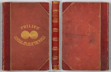
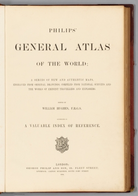


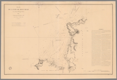


![[Europe.]](https://www.davidrumsey.com/rumsey/Size2/RUMSEY~8~1/213/14489003.jpg)
![[Europe.]](https://www.davidrumsey.com/rumsey/Size2/RUMSEY~8~1/213/14489004.jpg)


![[France.]](https://www.davidrumsey.com/rumsey/Size2/RUMSEY~8~1/213/14489021.jpg)
![[Armorican Massif, France.]](https://www.davidrumsey.com/rumsey/Size2/RUMSEY~8~1/213/14489025.jpg)
![[Loire River.]](https://www.davidrumsey.com/rumsey/Size2/RUMSEY~8~1/213/14489026.jpg)
![[Loire River.]](https://www.davidrumsey.com/rumsey/Size2/RUMSEY~8~1/213/14489027.jpg)


![[North and South America.]](https://www.davidrumsey.com/rumsey/Size2/RUMSEY~8~1/213/14489044.jpg)
![[South America.]](https://www.davidrumsey.com/rumsey/Size2/RUMSEY~8~1/213/14489045.jpg)


