|
Author
[Lattre, Jean, 1743 -1793, Janvier, Jean]
Full Title
L'Amerique, divisee en ses principaux etats, ... par le Sr. Janvier, Geographe ... 1769. (to accompany) Atlas Geographique contenant la Mappemonde et les quatre parties, avec les differents Etats, avec apprpbation & privilage du Roy MDCC.LXIII (1763).
List No
11335.012
Note
Engraved outlined hand color map. Relief shown pictorially. Showing political boundaries and place names. Includes ornamental cartouche and notes.
Author
[Lattre, Jean, 1743 -1793, Bonne, Rigobert, 1727-1794]
Full Title
Partie de l'Amerique Septentrionale : qui comprend le Canada, la Louisiane, le Labrador, le Groenland, les Etats-Unis et la Floride &c. Par Mr. Bonne. 1776. (to accompany) Atlas Geographique contenant la Mappemonde et les quatre parties, avec les differents Etats, avec apprpbation & privilage du Roy MDCC.LXIII (1763).
List No
11335.042
Note
Engraved outlined hand color map. Includes place names, and descriptive notes. Relief shown pictorially. Sheets also numbered XXXIV.
Author
Euler, Leonhard, 1707-1783
Full Title
Tab. Geogr. Americae : ad emendatiora quae adhuc prodierunt exempla jussu Acad. Reg. Scient. et Eleg. Litt. Boruss. descripta. (to accompany) Atlas geographicus omnes orbis terrarum regiones = Atlas geographique representant en XLI cartes toutes les regions de la terre ... Berolini : Ex officina Michaelis MDCCLIII (1753).
List No
11392.049
Note
Hand colored copperplate engraving map on 2 sheets. Showing political boundaries, geographic features, mountains, cities, and principal towns. Showing rivers and lakes, including Lacus Ouinipigon, appear to make way for a Northwest Passage in North America. The northern part of California is labeled Nova Albion. Relief shown pictorially. In lower right corner: 2. America.
Author
[Mazuyer, Gabriel, Lecomte, Georges (1867-1958), Boucher, Lucien (1889-1971)]
Full Title
A. Chiris en Amerique. (to accompany) Les etablissements Antoine Chiris, Dans le Monde. Les Etablissements Antoine Chiris dans le monde; Preface de Georges Lecomte de l'Academie Francaise; Texte historique de G. Mazuyer ; accompagne de 5 cartes illustrees de Lucien Boucher. Edite par les Etablissements Antoine Chiris, 1931.
List No
11452.014
Note
Pictorial map of Americas, showing section of Europe and Africa.
Author
[Janssonius van Waesberge, Johannes, Mercator, Gerhard, 1512-1594, Cloppenburg, Johannes, 1592-1652]
Full Title
America noviter delineata. (to accompany) Atlas sive Cosmographicae Meditationes de Fabrica mundi et fabricati figura. De novo multis in locis emendatus novisque tabulis auctus. Amsterodami, apud Iohannem Ianssonium van Waesberge. Anno, 1673. ( inset) I. S. Thomae.
List No
11487.175
Note
Copper engraved map of Americas. North America is shown with a peninsula California, Hudson Bay is left open to the west for the possibility of a northwest passage to Asia. South America shows with mythical islands of Brazil and Frisland. Map shows towns, villages, landmarks, mountains, and rivers. Relief shown pictorially.
Author
[Zatta, Antonio, active 1757-1797, Zuliani, Giuliano]
Full Title
L'America divisa ne' suoi principali stati : Di Nuovo projezione. Venezia 1776. Presso Antonio Zatta. G. Zuliani incise. (to accompany) Atlante novissimo ... Tomo IIII. Con privilegio dell Eccelimo Senato. (tomo I-IV).
List No
11598.222
Note
Engraved hand-colored in outline, double-page map, with decorative title cartouche. Shows political divisions, settlements, cities, towns, mountains and rivers. Relief shown by hachures. Travel route taken by Captain James Cook in 1768-71 shown with dotted lines. Includes islands in the Pacific, New Zealand, notes on New Zealand and the Northwest portion of the Americas.
Author
[Meyer, Joseph, 1796-1856, David, Jon.]
Full Title
America 1849 : Nach Arrowsmith, Brue und Lapie, mit Benutzung der neuesten Vermessungen. Joh. David sculp. Stich, Druck und Verlag der geographischen Anstalt des Bibliographischen Instituts. (In upper margin) Meyer's Zeitung Atlas. No. 28. (to accompany) Neuester Zeitungs-Atlas fur Alte und Neue Erdkunde. Herausgegeben von J. Meyer.
List No
11652.019
Note
Engraved outline hand color map. Shows political boundaries, cities and towns. Relief shown by hachures. Prime meridian is Ferro.
Author
Marmocchi, Francesco Constantino, 1805-1858
Full Title
Geografia Fisica. Parte second : Africa, Asia e America. (to accompany) Atlante di geografia universale ... Di F.C. Marmocchi. Firenze : per Vincenzo Batelli e Compagni 1842.
List No
11713.052
Note
Colored geologic cross- sections on the conformity of the earth. Part 2nd., showing volcanoes and comparative height of the mountains in Africa, Asia and America.
Author
[Meissas, Achille, 1799-187, Michelot, Auguste Jean Charles, 1792-1854]
Full Title
Amerique: pour la Petite geographie methodique et le Manuel de geographie de MM. Achille Meissas et Auguste Michelot. 1856. A la Librairie de L. Hachette. Grave sur Acier, par Dumortier, Ecrit par P.Rousset - Charle del. (to accompany) Petit atlas universel de geographie Ancienne du Moyen Age et Moderne et de geographie sacree.
List No
11740.016
Note
Colored in outline double page steel engraving map of America. Showing political divisions, capitals, major cities, rivers and mountains. Relief shown pictorially. In upper right: Atlas Complet. No. 6. Includes legend.
Author
[Meissas, Achille, 1799-187, Michelot, Auguste Jean Charles, 1792-1854]
Full Title
Amerique: pour la Petite geographie methodique et le Manuel de geographie de MM. Achille Meissas et Auguste Michelot. 1860. A la Librairie de L. Hachette. Charle del. Dumortier, Sculp. (to accompany) Petit atlas universel de geographie Ancienne du Moyen Age et Moderne et de geographie sacree.
List No
11740.017
Note
Outline map of America on 2 sheets, Supplement to Pl. 6. Political and administrative divisions, capitals and major cities are marked. Relief shown Pictorially. Includes legend.
Author
Visscher, Nicolaes, 1649-1702.
Full Title
Novissima et accuratissima totius Ameriae. Per N. Visscher. (to accompany) Atlas minor sive totius orbis terrarum contracta delinea ex conatibus Nico. Visscher. 1690. (half title page) Atlas Minor sive Geographia Compendiosa, qua Orbis Terrarum.
List No
11755.123
Note
Hand colored in outline engraved map of the Western Hemisphere, showing California as an Island and a small slice of New Zealand at the lower left corner, open ended Great Lake, conjectural Northwest Passage, Straits on Anian. Shows political boundaries, cities, towns, waterways, canals, landmarks Indian settlements and mountains. Includes decorative carouches, compass roses and vignette of natives in South America. Relief shown pictorially.
Author
[Santini, Paolo, Janvier]
Full Title
43. L'Amerique.
List No
12039.126
Author
Seutter, Matthaeus, 1678-1756
Full Title
4. Novis Orbis sive America.
List No
12041.025
Author
Logerot, A.
Full Title
Nouvelle Carte Elementaire de L'Amerique du Nord a l'Usage des Ecoles. Nouvelle Carte Elementaire de L'Amerique du Sud a l'Usage des Ecoles.
List No
12051.018
Author
Palairet, Jean
Full Title
Carte Generale de l'Amerique 1754.
List No
12055.018
Author
Speed, John, 1542-1629
Full Title
America.
List No
12058.177
Author
[Briet, Philip, 1601-1668, Cramoisy, Sebastiani, Cramoisy, Gabrielis]
Full Title
La Division de L'Ocean du Nouveau Monde.
List No
12063.040
Author
Heck, Johann Georg, 1795 -1857
Full Title
55 et 59. Carte Generale des deux Ameriques.
List No
12128.060
Author
Homann, Johann Baptist, 1663-1724
Full Title
Americae.
List No
12138.039
Author
[Ewald, Ludwig 1813-1881, Bauerkeller, Georg Leonhart]
Full Title
No. 31. America.
List No
12189.053
Author
[Ewald, Ludwig 1813-1881, Bauerkeller, Georg Leonhart]
Full Title
No. 37. America ... Uebersicht der Meer - u. Stromgebiete.
List No
12189.059
Author
[Ewald, Ludwig 1813-1881, Bauerkeller, Georg Leonhart]
Full Title
No. 44. America ... Uebersicht der americanischen Staaten und europaeischen Besitzungen.
List No
12189.066
Author
Fer, Nicolas de, 1646-1720
Full Title
L'Amerique, Meridionale et Septentrionale.
List No
12201.131
Author
Blaeu, Willem Janszoon, 1571-1638
Full Title
Americae nova Tabula.
List No
12202.007
Author
Homann, Johann Baptist, 1663-1724
Full Title
Totius Americae Septentrionales et Meridionalis.
List No
12499.059
Author
[Homann, Johann Baptist, 1663-1724, Danckerts, J.]
Full Title
America Septentrionalis et Meridionalis.
List No
12499.209
Author
Johnston, Alexander Keith, 1804-1871
Full Title
River Systems of America. (insets) Niagara River and Falls. Mississippi Delta. Orinoco.
List No
12509.062
Author
Legrand, Augustin
Full Title
Exposition geographique XIV Tableau : Amerique. 2me. Degre d'enseignement. 3me. Partie. (to accompany) 1839 Exposition geographique ... Par Augustin Legrand ... Paris. (insets) Supplement pour les Etats- Unis. (with) Les Antillrd : Carte Supplementaire. (with) Oceanie: Monde maritime 5me. Section.
List No
13118.015
Note
Hand colored in outline map of America. Shows political and administrative boundaries, capitals, major cities and rivers. Includes notes. Relief shown by hachures and pictorially. Prime meridian is Paris. Includes color coded key to European possessions in West Indies and Oceania.
Author
[Wyld, James, 1812-1887, Wyld, James, 1790-1836]
Full Title
Map of America. London. Published by James Wyld 1838. (to accompany) A new general atlas of modern geography : consisting of a complete collection of maps of the four quarters of the globe ...
List No
13170.053
Note
Double page engraved map, hand colored in outline. Shows political boundaries, major cities and towns, Russian-American possessions and The northern coast includes the discoveries of Franklin and Richardson, Dease and Simpson. Relief shown pictorially and by hachures.
Author
Stieler, Adolf, 1775–1836
Full Title
America : gezeichnet von F. v. Stulpnagel. gest v. W. Behrens. Stieler's Hand-Atlas No. 78. Gotha: Justus Perthes. 1874.
List No
13563.101
Note
Outline color map of the Americas.
Author
Andriveau-Goujon, E. (Eugène), 1832-1897
Full Title
Tableau comparatif de la hauteur des montagnes de la longueur du cours des fleures et de l'elevation des principales chûtes d'eau dans les cinq parties di monde faisant partie de l'atlas classique de C. V. Monin.
List No
14008.002
Note
Hand-colored, engraved diagram showing the comparative heights of mountains, lengths of rivers and heights of waterfalls in Europe, Asia, Africa and America. Includes index to mountains in left and right margins (with data and geographic locations), as well as descriptive text below: Observations physiques relatives aux montagnes. Diagram pasted onto verso of front cover, over marbled paper.
Author
[Morden, Robert, approximately 1650-1703, Cockerill, Thomas, active 1674-1702]
Full Title
(Text Page to) Of Maltha (2) -- Of America (1).
List No
14323.173
Note
On left - descriptive text for map, Maltha, on prior page (359). Text spans pages 359-360. On right - map of the Americas. Map includes title: America, by R. Morden. Shows political boundaries, cities, topography, drainage, coastline and islands. Relief shown pictorially. Contains latitudinal and longitudinal lines. Map is 10 x 12 cm, on sheet 15 x 20 cm. Accompanied by descriptive text. Text spans pages 361-364.
Author
Bartholomew, John
Full Title
The Americas. Lambert Zenithal Equal-Area Projection, Centre 20 (degree) N. 75 (degree) W. The Geographical Institute Edinburgh. Edited by John Bartholomew, M.C. LL. D. Copyright - John Bartholomew & Son, LTD.
List No
1552.245
Note
Full color map. Relief shown by shadings. The sea contour is drawn at 200 meters. Prime meridian is Greenwich. No. 1440 and Sep 56 marked on the lower corners of plate. The Times Atlas, and Frotispiece Vol. V on the upper corners of plater.
Author
Cary, John, ca. 1754-1835
Full Title
The Western Hemisphere. London: Published by J. Cary, Engraver & Map-seller, No. 181, Strand, Augst. 1, 1799.
List No
1657.002
Note
Engraved circular map. Country boundaries in outline hand col. Relief shown pictorially. Shows routes of Clerke, Cook, Gores, La Perouse, Pickersgills and Vancouver. Geographic and historic notes throughout the map. "2" pasted on verso.
Author
Cary, John, ca. 1754-1835
Full Title
A new map of America, from the latest authorities. By John Cary, engraver, 1806. London: Published by J. Cary, Engraver & Map-seller, No. 181, Strand, Septr. 1st, 1806.
List No
1657.052
Note
Engraved map. Boundaries in outline hand col. Relief shown pictorially. "50" pasted on verso.
Author
[Geographisches Institut (Weimar, Germany), Kiepert, Heinrich, 1818-1899]
Full Title
America. Bearbeitet und gezeichnet von H. Kiepert. Gestochen v. C. Jungmann. Weimar, Verlag des Geographischen Instituts, 1856.
List No
2077.059
Note
Engraved map. Outline hand col. Relief shown by hachures. Shows settlements, boundaries, ocean currents, etc. Prime meridian: Ferro.
Author
[Anville, Jean Baptiste Bourguignon d, 1697-1782, Faden, William, 1750?-1836]
Full Title
A map of America or the New World, wherein are introduced all the known parts of the Western Hemisphere, from the map of D'Anville; with the necessary alterations, and the addition of the discoveries made since the year 1761. London: published by W. Faden, Geographer to the King and to H.R.H. the Prince of Wales, Charing-Cross, April 12th, 1797. Wm. Palmer sculp.
List No
2104.052
Note
Engraved map. Hand col. Relief shown pictorially. Shows settlements, Indian tribes, 1493 line of demarcation between Spanish and Portuguese possessions, etc. Prime meridian: Ferro. "49" on verso.
Author
Vandermaelen, Philippe, 1795-1869
Full Title
(Composite of) Amer. Sep. no. 1 - 76 and Amer. Merid. no. 1 - 43. (Dresse par Ph. Vandermaelen, lithographie par H. Ode. 1827)
List No
2212.394
Note
This composite of all 119 maps of North and South America was created by georeferencing the maps individually in a Polyconic projection with the central meridian at 88.5 degrees west. Then all the maps were trimmed beyond their neat lines and joined. Relief shown pictorially; depths by soundings. Prime meridian: Paris.
Author
Robert Laurie & James Whittle
Full Title
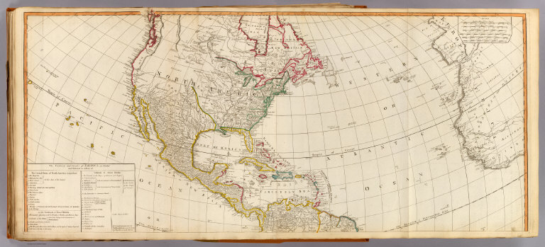
(A new map of the whole continent of America, divided into north and south and West Indies. North half. Wherein are exactly described the United States of North America as well as the several European possessions according to the Preliminaries of Peace signed at Versailles Jan. 20, 1783. Compiled from Mr. d'Anville's maps of that continent, with the addition of the Spanish discoveries in 1775 to the north of California & corrected in the several parts belonging to Great Britain, from the original materials of Governor Pownall, MP. London, Publish'd by Laurie & Whittle, No. 53, Fleet Street, as the act directs 12th May, 1794)
List No
2310.077
Note
Hand colored engraved map. Relief shown pictorially. Shows colonies, cities, Indian tribes, rivers, etc. Includes table: The continent and islands of America as divided and possessed ... Prime meridian: Ferro. Printed on 2 sheets; joined.
Author
[Anville, Jean Baptiste Bourguignon d, 1697-1782, Pownall, Thomas, Robert Laurie & James Whittle]
Full Title
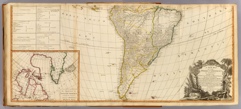
A new map of the whole continent of America, divided into north and south and West Indies. (South half). (with) The supplement to North America containing the countries adjoining to Baffins & Hudsons bays. Wherein are exactly described the United States of North America as well as the several European possessions according to the Preliminaries of Peace signed at Versailles Jan. 20, 1783. Compiled from Mr. d'Anville's maps of that continent, with the addition of the Spanish discoveries in 1775 to the north of California & corrected in the several parts belonging to Great Britain, from the original materials of Governor Pownall, MP. London, Publish'd by Laurie & Whittle, No. 53, Fleet Street, as the act directs 12th May, 1794.
List No
2310.078
Note
Hand colored engraved map with inset. Relief shown pictorially. Shows colonies, cities, Indian tribes, rivers, etc. Includes table: The continent and islands of America as divided and possessed ... Illustrated cartouche. Prime meridian: Ferro. Printed on 2 sheets; joined.
Author
[Anville, Jean Baptiste Bourguignon d, 1697-1782, Pownall, Thomas, Robert Laurie & James Whittle]
Full Title
(Composite of) A new map of the whole continent of America, divided into north and south and West Indies. (South half). (with) The supplement to North America containing the countries adjoining to Baffins & Hudsons bays. Wherein are exactly described the United States of North America as well as the several European possessions according to the Preliminaries of Peace signed at Versailles Jan. 20, 1783. Compiled from Mr. d'Anville's maps of that continent, with the addition of the Spanish discoveries in 1775 to the north of California & corrected in the several parts belonging to Great Britain, from the original materials of Governor Pownall, MP. London, Publish'd by Laurie & Whittle, No. 53, Fleet Street, as the act directs 12th May, 1794.
List No
2310.079
Note
Digital composite of 2 hand colored engraved maps. Relief shown pictorially. Shows colonies, cities, Indian tribes, rivers, etc. Includes table: The continent and islands of America as divided and possessed ... Illustrated cartouche. Prime meridian: Ferro. Printed on 4 sheets; joined as 2.
Author
[Stieler, Adolf, Petermann, A.]
Full Title
Polynesien Und Der Grosse Ocean Im Maassstabe von 1:40.000.000. (Ostliches Blatt) Von A. Petermann. Gezeichnet v. E. Debes. Gest v. C. Stier. Gotha: Justus Perthes 1872.
List No
2449.083
Note
Map of islands in the eastern Pacific Ocean showing the United States and the coastline of South America. 17 inset maps detail the individual islands in the region.
Author
Hunt, Marianne
Full Title
(Text Page to) Amerique Physique. (to accompany) Cours de Geographie. Institution de Mme. Butler. Saint-Omer. Marianne Hunt. 1844.
List No
2503.027
Note
Text to physical geography of America.
Author
Hunt, Marianne
Full Title
(Text Page to) Amerique Physique. (to accompany) Cours de Geographie. Institution de Mme. Butler. Saint-Omer. Marianne Hunt. 1844.
List No
2503.028
Note
Text to physical geography of America.
Author
Hunt, Marianne
Full Title
Amerique Physique. (to accompany) Cours de Geographie. Institution de Mme. Butler. Saint-Omer. Marianne Hunt. 1844. (inset) Is. du N. Shetland Merid.
List No
2503.029
Note
Physical map of America. Outline hand color, on page 27x34. Relief shown by hachures. Includes notes and inset.
Author
Hunt, Marianne
Full Title
(Text Page to) Amerique Physique. (to accompany) Cours de Geographie. Institution de Mme. Butler. Saint-Omer. Marianne Hunt. 1844.
List No
2503.030
Note
Text to Physical geography of America.
Author
Hunt, Marianne
Full Title
(Text Page to) Amerique Physique. (with) Amerique Politique. (to accompany) Cours de Geographie. Institution de Mme. Butler. Saint-Omer. Marianne Hunt. 1844.
List No
2503.031
Note
Text to Physical and political geography of America.
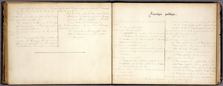
Author
Hunt, Marianne
Full Title
(Text Page to) Amerique Politique. (to accompany) Cours de Geographie. Institution de Mme. Butler. Saint-Omer. Marianne Hunt. 1844.
List No
2503.032
Note
Text to political geography of America.
Author
Hunt, Marianne
Full Title
Amerique Politique. (to accompany) Cours de Geographie. Institution de Mme. Butler. Saint-Omer. Marianne Hunt. 1844.(inset) Is. du N. Shetland Merid.
List No
2503.033
Note
Political map of America. Outline hand color, on page 27x34. Shows political boundaries and major cities. Includes explanation, notes and inset.
Author
Arrowsmith, Aaron Jr.
Full Title
America. London, Published Jany. 4.1825 by A. & S. Arrowsmith, No.10 Soho Square.
List No
2550.041
Note
Hand color map, with colored boundaries. Showing regions, place names, rivers, etc. Relief shown by hachures. Prime meridian is Greenwich.
|