|
Author
Mitchell, Samuel Augustus Jr.
Full Title
County and township map of the state of Maine. Copyright 1882 by Bradley & Company.
List No
0592.012
Note
Hand colored. Relief shown by hachures. Shows settlements, railroads, rivers, etc. Prime meridians: Greenwich and Washington.
Author
Mitchell, Samuel Augustus Jr.
Full Title
County and township map of Vermont and New Hampshire. Copyright 1882 by Bradley & Sons.
List No
0592.013
Note
Hand colored. Relief shown by hachures. Shows settlements, railroads, rivers, etc. Prime meridians: Greenwich and Washington.
Author
Mitchell, Samuel Augustus Jr.
Full Title
County map of the state of New Jersey. Copyright 1882, by Bradley & Company.
List No
0592.018
Note
Hand colored. Relief shown by hachures. Shows settlements, railroads, rivers, etc. Prime meridians: Greenwich and Washington.
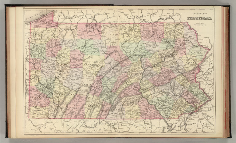
Author
Mitchell, Samuel Augustus Jr.
Full Title
County map of Pennsylvania. Copyright 1882, by Bradley & Company.
List No
0592.019
Note
Hand colored. Relief shown by hachures. Shows settlements, railroads, rivers, etc. Prime meridians: Greenwich and Washington.
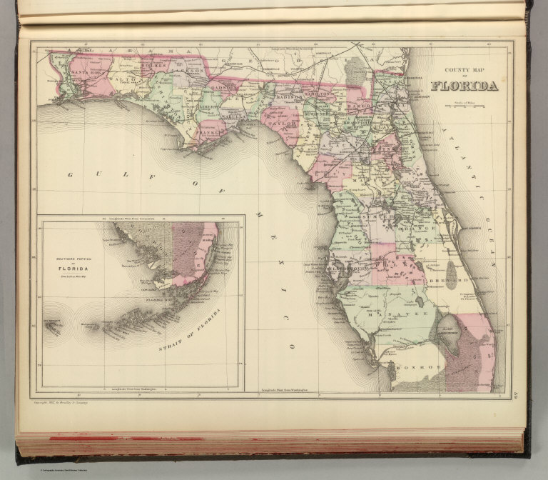
Author
Mitchell, Samuel Augustus Jr.
Full Title
County map of Florida. Copyright 1882 by Bradley & Company.
List No
0592.028
Note
Hand colored. Shows settlements, railroads, rivers, etc. Inset: Southern portion of Florida. Prime meridians: Greenwich and Washington.
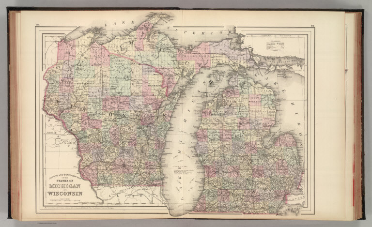
Author
Mitchell, Samuel Augustus Jr.
Full Title
County and township map of the states of Michigan and Wisconsin. Entered ... 1882 by S. Augustus Mitchell....
List No
0592.040
Note
Hand colored map. Shows settlements, railroads, rivers, etc. Prime meridians: Greenwich and Washington.
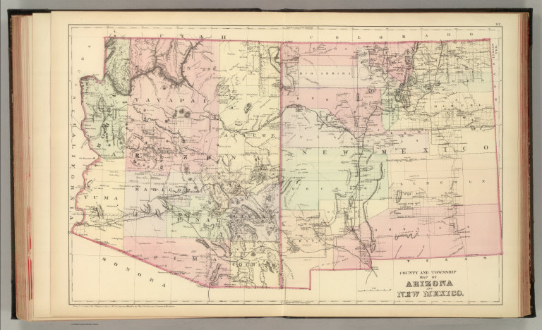
Author
Mitchell, Samuel Augustus Jr.
Full Title
County and township map of Arizona and New Mexico. Entered ... 1882 by S. Augustus Mitchell....
List No
0592.049
Note
Hand colored. Relief shown by hachures. Shows Indian reservations, military reservations, inhabited places, railroads, drainage, etc. Prime meridians: Greenwich and Washington.
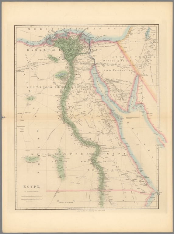
Author
[Arrowsmith, John, 1790-1873, Stanford, Edward, 1827-1904]
Full Title
Egypt. By J. Arrowsmith. London: Edward Stanford, 55 Charing Cross, S.W. May 1st. 1882. (to accompany) Stanford's London Atlas Of Universal Geography. Folio edition.
List No
11741.043
Note
Outline hand color folded map. Showing administrative divisions, cities, towns, landmarks, roads, canals, submarine cables, mountains and rivers. Relief shown by hachures. Prime meridian is Greenwich.
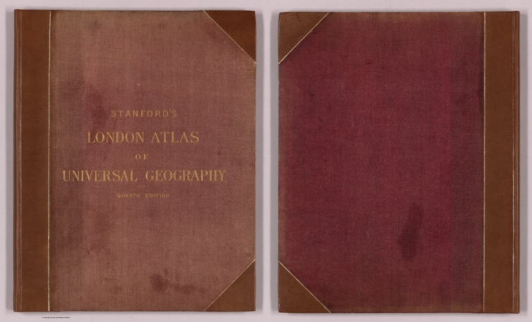
Author
Stanford, Edward, 1827-1904
Full Title
(Covers to) Stanford's London atlas of universal geography : Quarto edition.
List No
14081.001
Note
Covers to Stanford's London atlas of universal geography : Quarto edition. Bound in leather-covered board, with title on front cover in gilt. Spine title, in gilt: London atlas of universal geography. Page edges in gilt.
Author
Stanford, Edward, 1827-1904
Full Title
(Title Page to) London atlas of universal geography.
List No
14081.002
Note
Half title page to Stanford's London atlas of universal geography : Quarto edition. Precedes full title page.
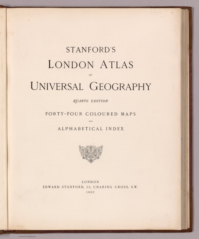
Author
Stanford, Edward, 1827-1904
Full Title
(Title Page to) Stanford's London atlas of universal geography : Quarto edition. Forty-four coloured maps and alphabetical index. London, Edward Stanford, 55 Charing Cross, S.W., 1882.
List No
14081.003
Note
Title page to Stanford's London atlas of universal geography : Quarto edition.
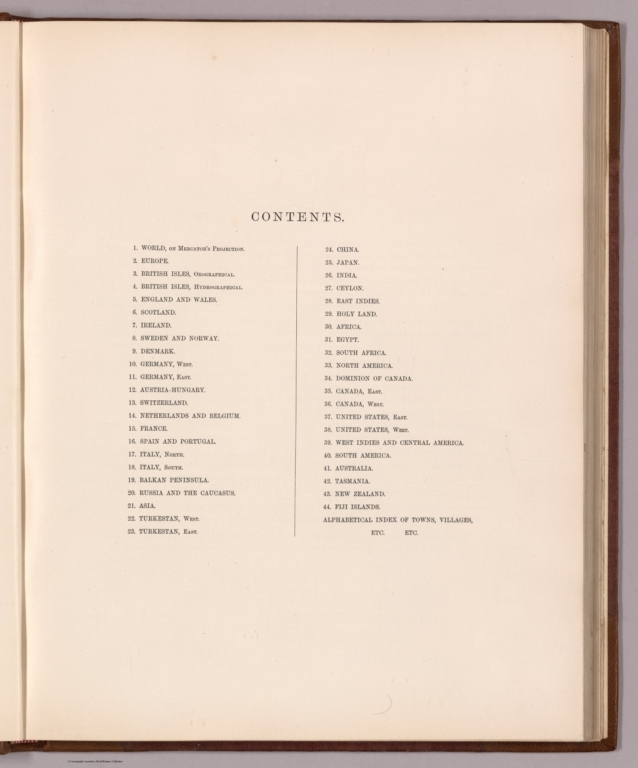
Author
Stanford, Edward, 1827-1904
Full Title
(Contents to) Contents.
List No
14081.004
Note
Table of contents to Stanford's London atlas of universal geography : Quarto edition, listing 44 maps, as well as "Alphabetical index of towns, villages, etc. etc.
Author
Stanford, Edward, 1827-1904
Full Title
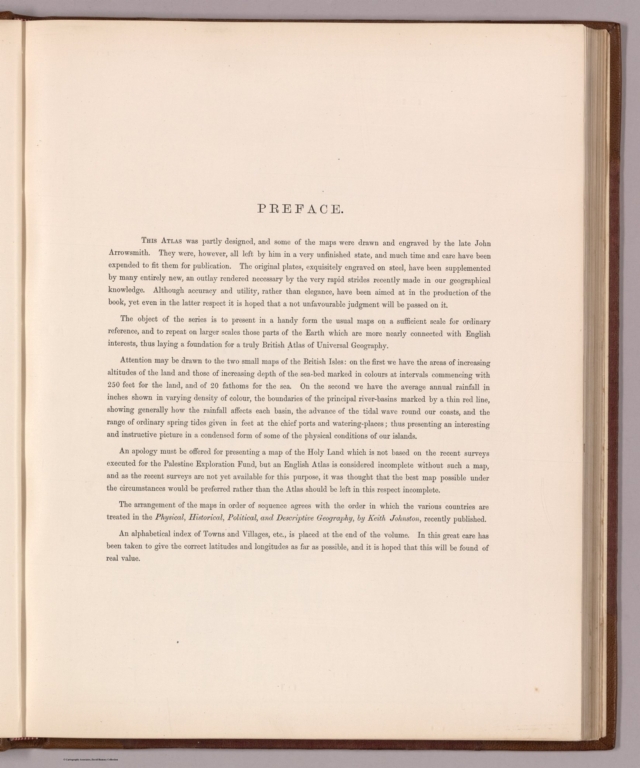
(Text Page to) Preface. May 1887.
List No
14081.005
Note
Preface to Stanford's London atlas of universal geography : Quarto edition, beginning: This atlas was partly designed, and some of the maps were drawn and engraved by the late John Arrowsmith. They were, however, all left by him in a very unfinished state, and much time and care have been expended to fit them for publication. The original plates, exquisitely engraved on steel, have been supplemented by many entirely new, an outlay rendered by the very rapid strides recently made in our geographical knowledge ... The object of the series is to present in a handy form the usual maps on a sufficient scale for ordinary reference, and to repeat on larger scales those parts of the Earth which are more nearly connected with English interests, thus laying a foundation for a truly British Atlas of Universal Geography.
Author
Stanford, Edward, 1827-1904
Full Title
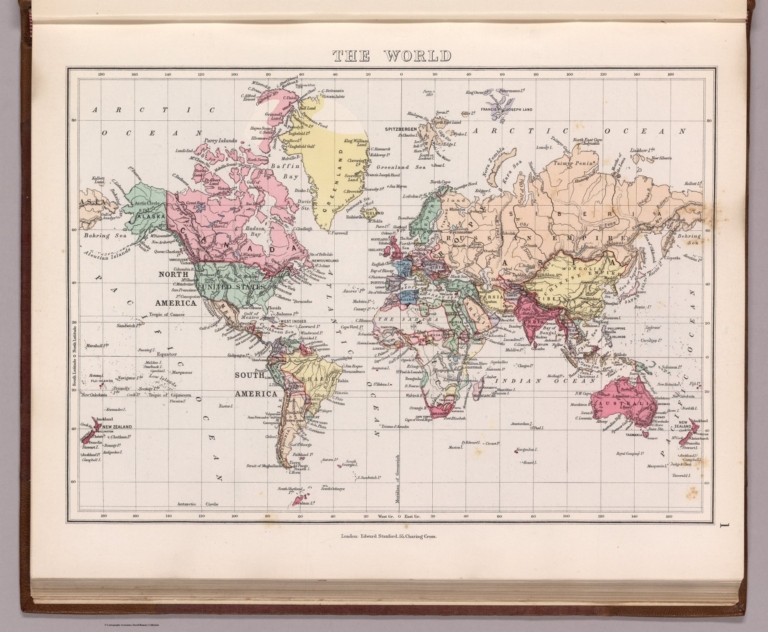
1. The world. London: Edward Stanford, 55, Charing Cross.
List No
14081.006
Note
Steel-engraved map, in color, of the world, on Mercator's projection. Relief illustrated with hachures. Shows political boundaries, topography and drainage. With latitudinal and longitudinal lines. 23 x 33 cm, on sheet 29 x 38 cm.
Author
Stanford, Edward, 1827-1904
Full Title
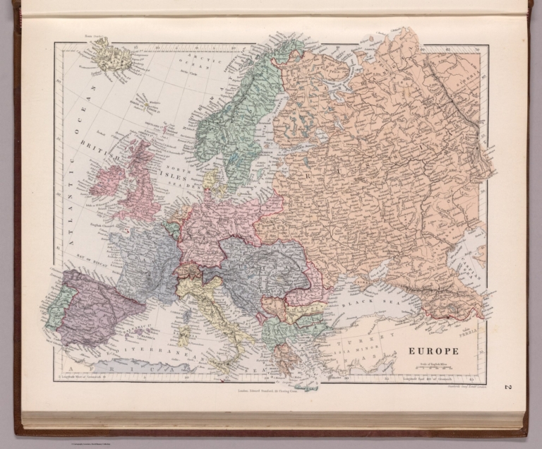
2. Europe. London. Edward Stanford, 55, Charing Cross. Stanford's Geogl. Estabt. London.
List No
14081.007
Note
Steel-engraved map, in color, of Europe. Relief illustrated with hachures. Shows political boundaries, topography and drainage. Includes a bar scale. With latitudinal and longitudinal lines. 28 x 34 cm, on sheet 29 x 38 cm.
Author
Stanford, Edward, 1827-1904
Full Title
3. Orographical map of the British Isles. London, Edward Stanford, 55, Charing Cross. Stanford's Geogl. Estabt.
List No
14081.008
Note
Steel-engraved map, in color, of the British Isles. Relief illustrated with hachures. Shows place names, topography and drainage. Features elevation in feet and soundings in fathoms. Includes a legend and a bar scale. With latitudinal and longitudinal lines. 31 x 27 cm, on sheet 38 x 29 cm.
Author
Stanford, Edward, 1827-1904
Full Title
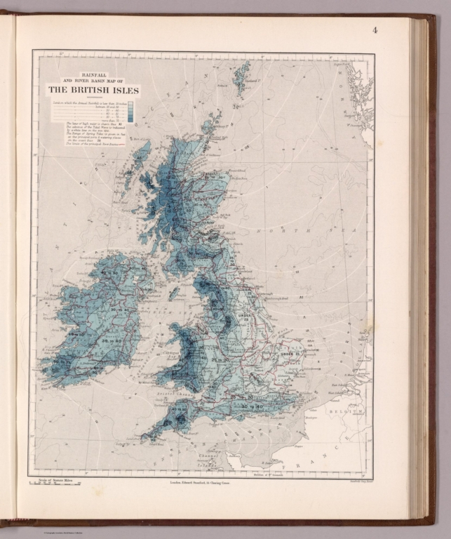
4. Rainfall and river basin map of the British Isles. London, Edward Stanford, 55, Charing Cross. Stanford's Geogl. Estabt.
List No
14081.009
Note
Steel-engraved map, in color, of the British Isles. Relief illustrated with hachures. Shows place names, topography and drainage. Features rainfall, river basins, and soundings in fathoms. Includes a legend and a bar scale, as well as explanatory text. With latitudinal and longitudinal lines. 31 x 27 cm, on sheet 38 x 29 cm.
Author
Stanford, Edward, 1827-1904
Full Title
5. England & Wales. London, Edward Stanford, 55, Charing Cross. Stanford's Geogl. Estabt. London.
List No
14081.010
Note
Steel-engraved map, in color, of England and Wales. Relief illustrated with hachures. Shows political boundaries, railways, topography and drainage. Includes a bar scale. With latitudinal and longitudinal lines. 33 x 28 cm, on sheet 38 x 29 cm.
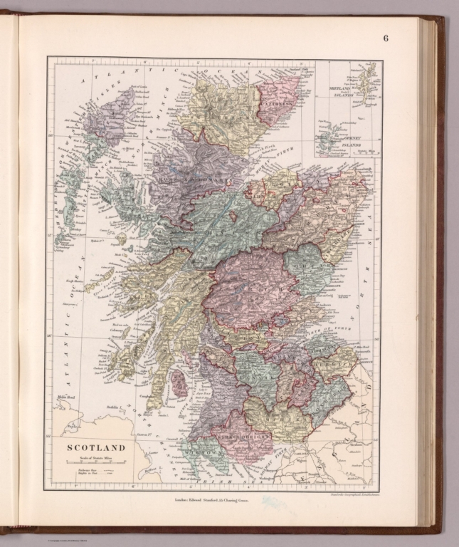
Author
Stanford, Edward, 1827-1904
Full Title
6. Scotland. London, Edward Stanford, 55, Charing Cross. Stanford's Geographical Establishment.
List No
14081.011
Note
Steel-engraved map, in color, of Scotland. Relief illustrated with hachures and spot heights. Shows political boundaries, railways, topography and drainage. Includes a legend and a bar scale. With latitudinal and longitudinal lines. Inset map: (Shetland Islands, Orkney Islands). 31 x 24 cm, on sheet 38 x 29 cm.
Author
Stanford, Edward, 1827-1904
Full Title
7. Ireland. London, Edward Stanford, 55, Charing Cross. Stanford's Geogl. Estabt. London.
List No
14081.012
Note
Steel-engraved map, in color, of Ireland. Relief illustrated with hachures. Shows political boundaries, railways, topography and drainage. Includes a legend and a bar scale. With latitudinal and longitudinal lines. 34 x 27 cm, on sheet 38 x 29 cm.
Author
Stanford, Edward, 1827-1904
Full Title
8. Sweden and Norway. London, Edward Stanford, 55, Charing Cross. Stanford's Geogl. Estabt.
List No
14081.013
Note
Steel-engraved map, in color, of Sweden and Norway. Relief illustrated with hachures. Shows political boundaries, railways, topography, drainage and submarine telegraph cables. Includes a legend and a bar scale. With latitudinal and longitudinal lines. Inset map: Continuation from Tornea to the North Cape. 35 x 28 cm, on sheet 38 x 29 cm.
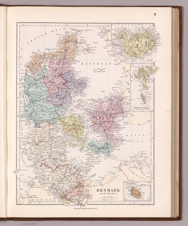
Author
Stanford, Edward, 1827-1904
Full Title
9. Denmark and the Duchies. London, Edward Stanford, 55, Charing Cross. Stanford's Geogl. Estabt. London.
List No
14081.014
Note
Steel-engraved map, in color, of Denmark and the Duchies. Relief illustrated with hachures. Shows political boundaries, railways, topography and drainage. Includes a legend and a bar scale. With latitudinal and longitudinal lines. Three inset maps: Iceland -- Ferröe or Færöe Is. -- Bornholm. 33 x 25 cm, on sheet 38 x 29 cm.
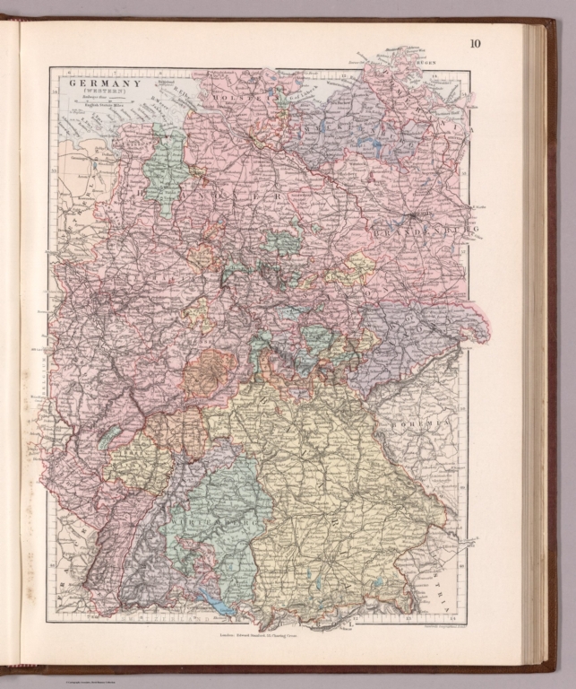
Author
Stanford, Edward, 1827-1904
Full Title
10. Germany (western). London, Edward Stanford, 55, Charing Cross. Stanford's Geographical Estabt.
List No
14081.015
Note
Steel-engraved map, in color, of western Germany. Relief illustrated with hachures and spot heights. Shows political boundaries, railways, topography, drainage and submarine telegraph cables. Includes a legend and a bar scale. With latitudinal and longitudinal lines. 35 x 27 cm, on sheet 38 x 29 cm.
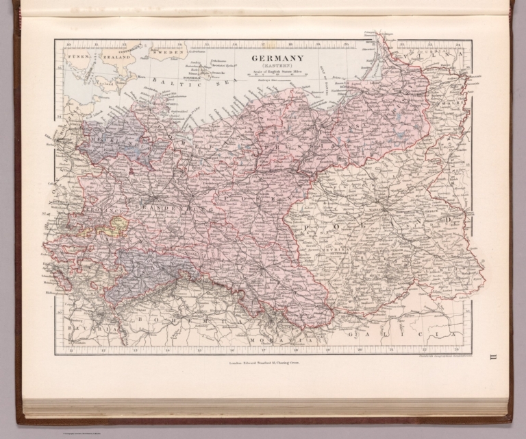
Author
Stanford, Edward, 1827-1904
Full Title
11. Germany (eastern). London, Edward Stanford, 55, Charing Cross. Stanford's Geographical Establishment.
List No
14081.016
Note
Steel-engraved map, in color, of eastern Germany. Relief illustrated with hachures. Shows political boundaries, railways, topography and drainage. Includes a legend and a bar scale. With latitudinal and longitudinal lines. 25 x 35 cm, on sheet 29 x 38 cm.
Author
Stanford, Edward, 1827-1904
Full Title
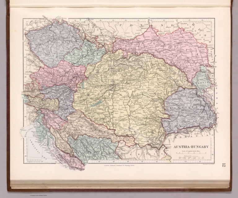
12. Austria-Hungary. London, Edward Stanford, 55, Charing Cross. Stanford's Geogl. Estabt.
List No
14081.017
Note
Steel-engraved map, in color, of Austria-Hungary. Relief illustrated with hachures. Shows political boundaries, railways, topography and drainage. Includes a legend and a bar scale, as well as a key for translations. With latitudinal and longitudinal lines. 27 x 34 cm, on sheet 29 x 38 cm.
Author
Stanford, Edward, 1827-1904
Full Title
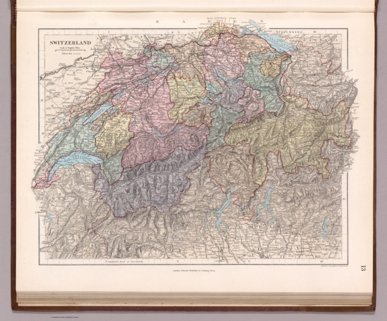
13. Switzerland. London, Edward Stanford, 55, Charing Cross. Stanford's Geographical Establishment.
List No
14081.018
Note
Steel-engraved map, in color, of Switzerland. Relief illustrated with hachures. Shows political boundaries, railways, topography and drainage. Includes a legend and a bar scale. With latitudinal and longitudinal lines. 26 x 35 cm, on sheet 29 x 38 cm.
Author
Stanford, Edward, 1827-1904
Full Title
14. Netherlands and Belgium. London, Edward Stanford, 55, Charing Cross. Stanford's Geogl. Estabt. London.
List No
14081.019
Note
Steel-engraved map, in color, of the Netherlands and Belgium. Relief illustrated with hachures. Shows political boundaries, railways, topography, drainage and submarine telegraph cables. Includes a legend and a bar scale. With latitudinal and longitudinal lines. 33 x 27 cm, on sheet 38 x 29 cm.
Author
Stanford, Edward, 1827-1904
Full Title
15. France. London, Edward Stanford, 55, Charing Cross. Stanford's Geogl. Estabt. London.
List No
14081.020
Note
Steel-engraved map, in color, of France. Relief illustrated with hachures. Shows political boundaries, railways, topography and drainage. Includes a legend and a bar scale. With latitudinal and longitudinal lines. Two inset maps: Sketch of France divided into provinces -- Corsica. 31 x 27 cm, on sheet 38 x 29 cm.
Author
Stanford, Edward, 1827-1904
Full Title
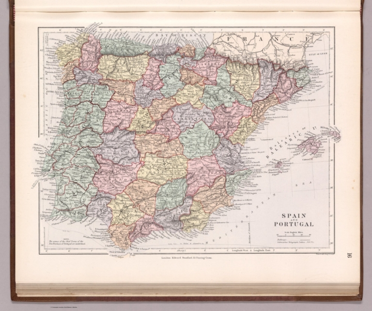
16. Spain and Portugal. London, Edward Stanford, 55, Charing Cross. Stanford's Geogl. Estabt.
List No
14081.021
Note
Steel-engraved map, in color, of Spain and Portugal. Relief illustrated with hachures. Shows political boundaries, railways, topography, drainage and submarine telegraph cables. Includes a legend and a bar scale. With latitudinal and longitudinal lines. 26 x 33 cm, on sheet 29 x 38 cm.
Author
Stanford, Edward, 1827-1904
Full Title
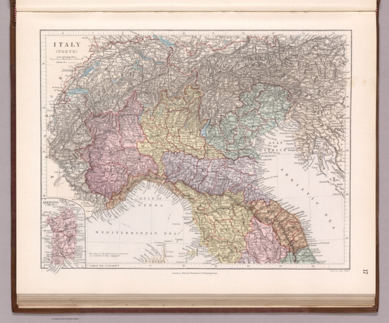
17. Italy (north). London, Edward Stanford, 55, Charing Cross. Stanford's Geogl. Estabt.
List No
14081.022
Note
Steel-engraved map, in color, of northern Italy. Relief illustrated with hachures. Shows political boundaries, railways, topography, drainage and submarine telegraph cables. Includes a legend and a bar scale. With latitudinal and longitudinal lines. 24 x 31 cm, on sheet 29 x 38 cm.
Author
Stanford, Edward, 1827-1904
Full Title
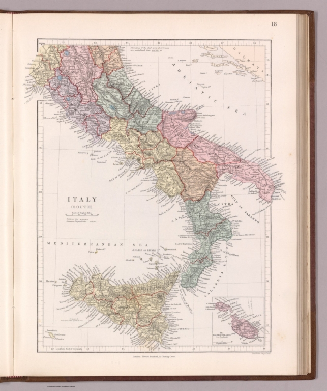
18. Italy (south). London, Edward Stanford, 55, Charing Cross. Stanford's Geogl. Estabt.
List No
14081.023
Note
Steel-engraved map, in color, of southern Italy. Relief illustrated with hachures. Shows political boundaries, railways, topography, drainage and submarine telegraph cables. Includes a legend and a bar scale. With latitudinal and longitudinal lines. Inset map: The Maltese Islands. 32 x 27 cm, on sheet 38 x 29 cm.
Author
Stanford, Edward, 1827-1904
Full Title
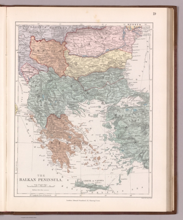
19. The Balkan Peninsula. London, Edward Stanford, 55, Charing Cross. Stanford's Geogl. Estabt.
List No
14081.024
Note
Steel-engraved map, in color, of the Balkan Peninsula. Relief illustrated with hachures. Shows political boundaries, railways, topography, drainage and submarine telegraph cables. Includes a legend and a bar scale. With latitudinal and longitudinal lines. 31 x 25 cm, on sheet 38 x 29 cm.
Author
Stanford, Edward, 1827-1904
Full Title
20. Russia and the Caucasus. London, Edward Stanford, 55, Charing Cross. Stanford's Geographical Establishment.
List No
14081.025
Note
Steel-engraved map, in color, of Russia and the Caucasus. Relief illustrated with hachures. Shows political boundaries, railways, topography, drainage, canals and submarine telegraph cables. Includes a legend and a bar scale. With latitudinal and longitudinal lines. 31 x 24 cm, on sheet 38 x 29 cm.
Author
Stanford, Edward, 1827-1904
Full Title
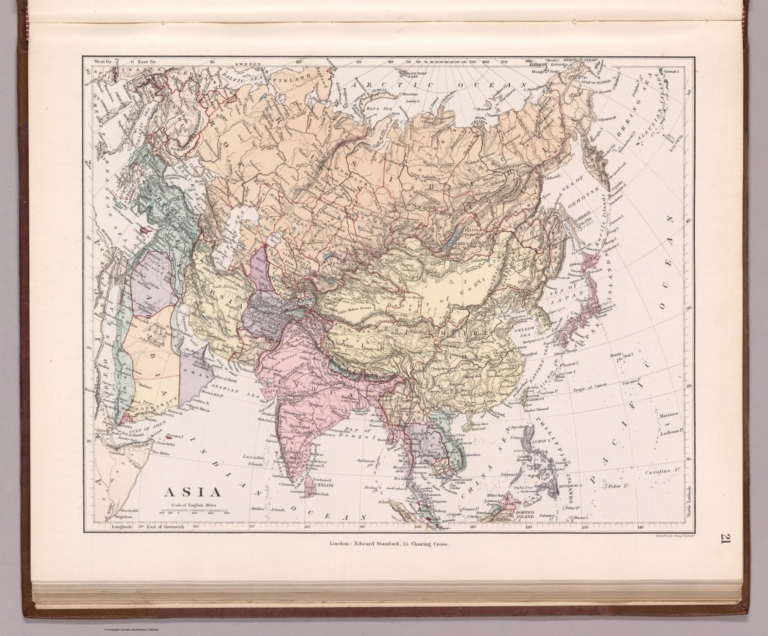
21. Asia. London, Edward Stanford, 55, Charing Cross. Stanford's Geogl. Estabt.
List No
14081.026
Note
Steel-engraved map, in color, of Asia. Relief illustrated with hachures. Shows political boundaries, topography and drainage. Includes a bar scale. With latitudinal and longitudinal lines. 25 x 31 cm, on sheet 29 x 38 cm.
Author
Stanford, Edward, 1827-1904
Full Title
22. Turkestan. London, Edward Stanford, 55, Charing Cross.
List No
14081.027
Note
Steel-engraved map, in color, of western Turkestan. Relief illustrated with hachures. Shows political boundaries, topography, drainage and submarine telegraph cables. Includes three bar scales. With latitudinal and longitudinal lines. 33 x 26 cm, on sheet 38 x 29 cm.
Author
Stanford, Edward, 1827-1904
Full Title
(Composite map of) 22 and 23 Turkestan. London, Edward Stanford, 55, Charing Cross.
List No
14081.052
Note
Steel-engraved map, in color, of western and eastern Turkestan. Relief illustrated with hachures. Shows political boundaries, topography, drainage and submarine telegraph cables. Includes three bar scales. With latitudinal and longitudinal lines.
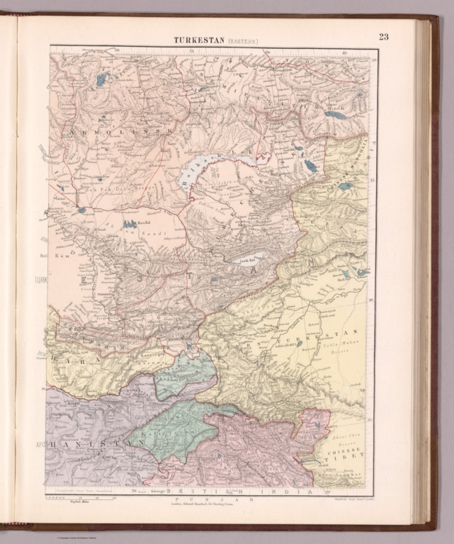
Author
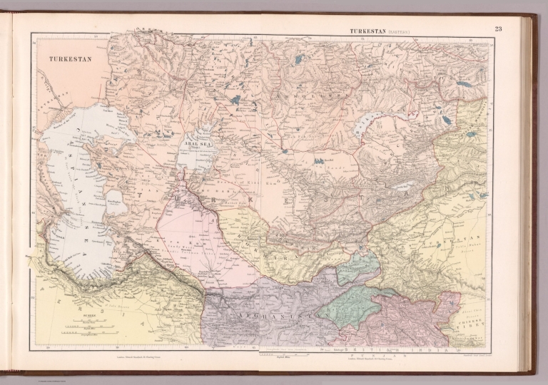
Stanford, Edward, 1827-1904
Full Title
23. Turkestan (eastern). London, Edward Stanford, 55, Charing Cross. Stanford's Geogl. Estabt. London.
List No
14081.028
Note
Steel-engraved map, in color, of eastern Turkestan. Relief illustrated with hachures. Shows political boundaries, topography and drainage. Includes a bar scale. With latitudinal and longitudinal lines. 32 x 25 cm, on sheet 38 x 29 cm.
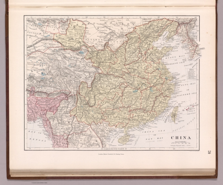
Author
Stanford, Edward, 1827-1904
Full Title
24. China. London, Edward Stanford, 55, Charing Cross. Stanford's Geogl. Estabt. London.
List No
14081.029
Note
Steel-engraved map, in color, of China. Relief illustrated with hachures. Shows political boundaries, topography, drainage and submarine telegraph cables. Includes a legend and a bar scale, as well as an index indicating Korean districts. With latitudinal and longitudinal lines. 24 x 31 cm, on sheet 29 x 38 cm.
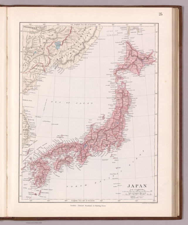
Author
Stanford, Edward, 1827-1904
Full Title
25. Japan. London, Edward Stanford, 55, Charing Cross. Stanford's Geog. Establishment.
List No
14081.030
Note
Steel-engraved map, in color, of Japan. Relief illustrated with hachures. Shows political boundaries, railways, topography, drainage and submarine telegraph cables. Includes a legends and two bar scales. With latitudinal and longitudinal lines. 31 x 25 cm, on sheet 38 x 29 cm.
Author
Stanford, Edward, 1827-1904
Full Title
26. India. London: Published by Edward Stanford, Charing Cross. Stanford's Geographical Establishment.
List No
14081.031
Note
Steel-engraved map, in color, of India. Relief illustrated with hachures. Shows political boundaries, railways, topography, drainage and submarine telegraph cables. Includes a legend and a bar scale. With latitudinal and longitudinal lines. 28 x 26 cm, on sheet 38 x 29 cm.
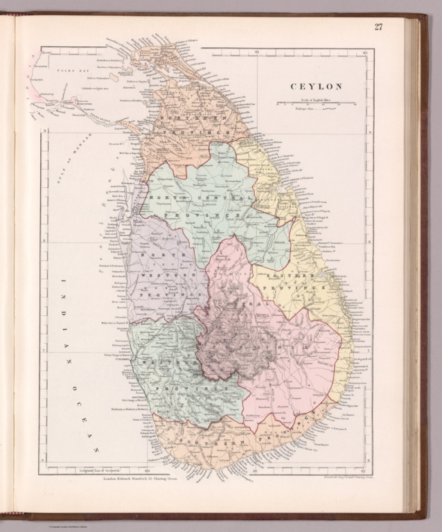
Author
Stanford, Edward, 1827-1904
Full Title
27. Ceylon. London, Edward Stanford, 55, Charing Cross. Stanford's Geogl. Estabt. London.
List No
14081.032
Note
Steel-engraved map, in color, of Ceylon. Relief illustrated with hachures. Shows political boundaries, railways, topography and drainage. Includes a legend and a bar scale. With latitudinal and longitudinal lines. 34 x 27 cm, on sheet 38 x 29 cm.
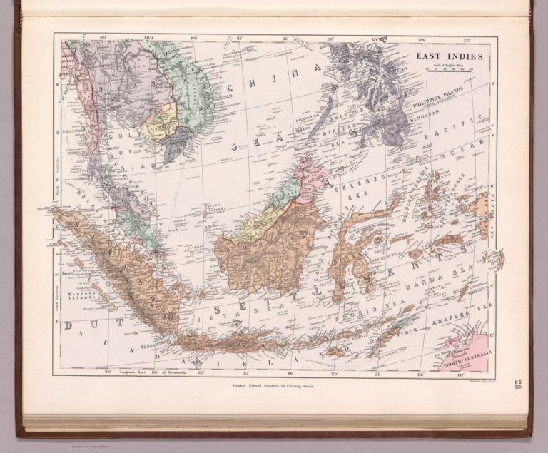
Author
Stanford, Edward, 1827-1904
Full Title
28. East Indies. London: Edward Stanford, 55, Charing Cross. Stanford's Geogl. Estabt.
List No
14081.033
Note
Steel-engraved map, in color, of the East Indies. Relief illustrated with hachures. Shows political boundaries, topography, drainage and submarine telegraph cables. Includes a bar scale. With latitudinal and longitudinal lines. 25 x 34 cm, on sheet 29 x 38 cm.
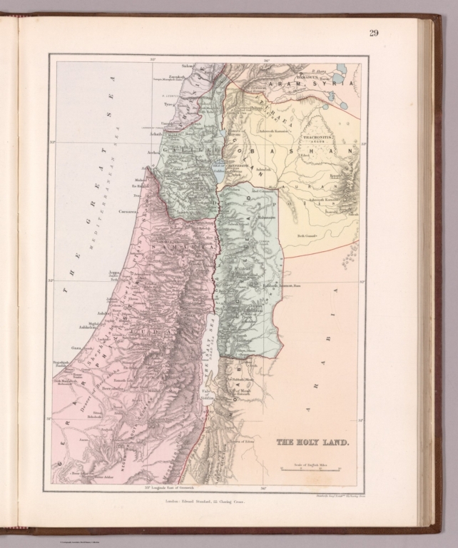
Author
Stanford, Edward, 1827-1904
Full Title
29. Holy Land. London: Edward Stanford, 55, Charing Cross. Stanford's Geogl. Estabmt. 55, Charing Cross.
List No
14081.034
Note
Steel-engraved map, in color, of the Holy Land. Relief illustrated with hachures. Shows political boundaries, topography and drainage. Includes a bar scale. With latitudinal and longitudinal lines. 31 x 23 cm, on sheet 38 x 29 cm.
Author
Stanford, Edward, 1827-1904
Full Title
30. Africa. London: Edward Stanford, 55, Charing Cross. Stanford's Geogl. Estabt. London.
List No
14081.035
Note
Steel-engraved map, in color, of Africa. Relief illustrated with hachures. Shows political boundaries, topography and drainage. Includes a bar scale. With latitudinal and longitudinal lines. 32 x 27 cm, on sheet 38 x 29 cm.
Author
Stanford, Edward, 1827-1904
Full Title
31. Egypt. London: Edward Stanford, 55, Charing Cross. Stanford's Geographical Estabt.
List No
14081.036
Note
Steel-engraved map, in color, of Egypt. Relief illustrated with hachures. Shows political boundaries, railways, topography, drainage and submarine telegraph cables. Includes a legend and a bar scale. With latitudinal and longitudinal lines. 31 x 27 cm, on sheet 38 x 29 cm.
Author
Stanford, Edward, 1827-1904
Full Title
32. South Africa. London: Edward Stanford, 55, Charing Cross. Stanford's Geographical Establishment.
List No
14081.037
Note
Steel-engraved map, in color, of South Africa. Relief illustrated with hachures. Shows political boundaries, railways, topography, drainage and submarine telegraph cables. Includes a legend and a bar scale, as well as a reference to fiscal districts. With latitudinal and longitudinal lines. 24 x 31 cm, on sheet 29 x 38 cm.
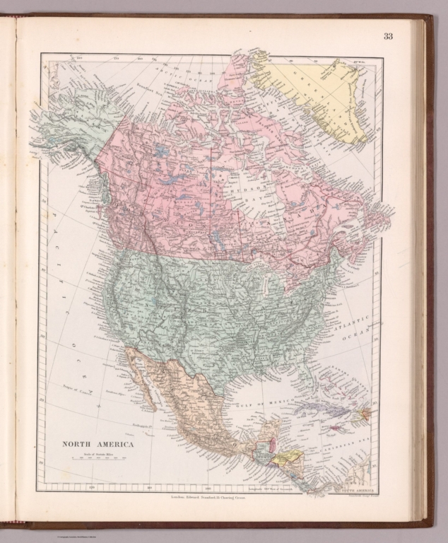
Author
Stanford, Edward, 1827-1904
Full Title
33. North America. London: Edward Stanford, 55, Charing Cross. Stanford's Geogl. Estabt.
List No
14081.038
Note
Steel-engraved map, in color, of North America. Relief illustrated with hachures. Shows political boundaries, topography and drainage. Includes a bar scale. With latitudinal and longitudinal lines. 34 x 28 cm, on sheet 38 x 29 cm.
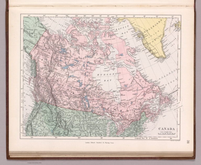
Author
Stanford, Edward, 1827-1904
Full Title
34. Canada. London: Edward Stanford, 55, Charing Cross. Stanford's Geogl. Estabt.
List No
14081.039
Note
Steel-engraved map, in color, of Canada. Relief illustrated with hachures. Shows political boundaries, topography, drainage and submarine telegraph cables. Includes a bar scale. With latitudinal and longitudinal lines. 24 x 32 cm, on sheet 29 x 38 cm.
Author
Stanford, Edward, 1827-1904
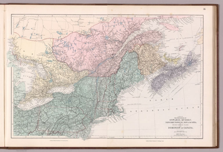
Full Title
35. A map of the provinces of Ontario, Quebec, New Brunswick, Nova Scotia and Prince Edward Island, in the dominion of Canada (east). London: Edward Stanford, 55, Charing Cross. Stanford's Geogl. Estabt. London.
List No
14081.040
Note
Steel-engraved map, in color, of eastern Canada. Relief illustrated with hachures. Shows political boundaries, railways, topography, drainage and submarine telegraph cables. Includes a legend and a bar scale. With latitudinal and longitudinal lines. 32 x 26 cm, on sheet 38 x 29 cm.
Author
Stanford, Edward, 1827-1904
Full Title
(Composte Map of) 35 and 36. A map of the provinces of Ontario, Quebec, New Brunswick, Nova Scotia and Prince Edward Island, in the dominion of Canada (east and west). London: Edward Stanford, 55, Charing Cross. Stanford's Geogl. Estabt. London.
List No
14081.053
Note
Steel-engraved map, in color, of eastern and western Canada. Relief illustrated with hachures. Shows political boundaries, railways, topography, drainage and submarine telegraph cables. Includes a legend and a bar scale. With latitudinal and longitudinal lines.
|