|
REFINE
Browse All : World Atlas from 1799
1-78 of 78
Author
[Depot General de la Marine, Beautemps Beaupré, Charles François]
Full Title
(Sheet 1) Reconnoissance Du Cours Du Hont ou Wester Schelde (Escault Occidental) depuis Antwerpen (Anvers) jusqu'a l'Embouchure
List No
15934.041
Note
Hydrographie Française 1
Author
Depot General de la Marine
Full Title
(Sheet 2) Reconnoissance Du Cours Du Hont ou Wester Schelde (Escault Occidental) depuis Antwerpen (Anvers) jusqu'a l'Embouchure
List No
15934.042
Note
Hydrographie Française 1
Author
Depot General de la Marine
Full Title
(Sheet 3) Reconnoissance Du Cours Du Hont ou Wester Schelde (Escault Occidental) depuis Antwerpen (Anvers) jusqu'a l'Embouchure
List No
15934.043
Note
Hydrographie Française 1
Author
Depot General de la Marine
Full Title
(Composite map of) (Sheets 1 - 3) Reconnoissance Du Cours Du Hont ou Wester Schelde (Escault Occidental) depuis Antwerpen (Anvers) jusqu'a l'Embouchure
List No
15934.044
Note
Hydrographie Française 1
Author
Luffman, John, 1756-1846
Full Title
Cadiz Harbour. Engraved for Luffman's Select plans of the principal cities, ports, harbours, forts, &c. in the world. London, - Engraved and published July 1. 1799, by John Luffman.
List No
13189.003
Note
Hand colored chart. Relief shown by hachures. Depth shown by soundings. Includes historical text at the foot of map.
Author
Luffman, John, 1756-1846
Full Title
Port Royal in Jamaica. Engraved for Luffman's Select plans of the principal cities, ports, harbours, forts, &c. in the world. London, - Engraved and published July 1. 1799, by John Luffman.
List No
13189.005
Note
Hand colored chart. Relief shown by hachures. Depth shown by soundings. Prime meridian is London. Includes historical text at the foot of map.
Author
Luffman, John, 1756-1846
Full Title
Fort Louis. Engraved for Luffman's Select plans of the principal cities, ports, harbours, forts, &c. in the world. London, - Engraved and published July 1. 1799, by John Luffman.
List No
13189.006
Note
Hand colored plan of the city and fortification. Relief shown by hachures. Prime meridian is London. Includes historical text at the foot of map.
Author
Luffman, John, 1756-1846
Full Title
Turin. Engraved for Luffman's Select plans of the principal cities, ports, harbours, forts, &c. in the world. London, - Engraved and published July 1. 1799, by John Luffman.
List No
13189.009
Note
Hand colored plan of the city and fortifications. Includes numbered key to the important sites on the map. Prime meridian is London.
Author
Luffman, John, 1756-1846
Full Title
Hunningen. Engraved for Luffman's Select plans of the principal cities, ports, harbours, forts, &c. in the world. London, - Engraved and published by John Luffman. London. Aug. 1t.1799.
List No
13189.010
Note
Hand colored plan of the city and fortifications. Prime meridian is London. Includes historical text at the foot of map.
Author
Wilkinson, Robert
Full Title
Russia in Europe with the Dismemberments from Poland in 1773, 1793, and 1795.
List No
1201.015
Author
Wilkinson, Robert
Full Title
Poland, with its Dismembered Provinces, Drawn from the Best Authorities.
List No
1201.052
Author
Wilkinson, Robert
Full Title
The Seven United Provinces with their Dependencies.
List No
1201.028
Author
Wilkinson, Robert
Full Title
A New and Accurate Map of the Netherlands or Low Countries.
List No
1201.029
Author
Wilkinson, Robert
Full Title
Russia in Europe with the Dismemberments from Poland in 1773, 1793, and 1795.
List No
1202.015
Author
Wilkinson, Robert
Full Title
The Seven United Provinces with their Dependencies.
List No
1202.029
Author
Wilkinson, Robert
Full Title
A New and Accurate Map of the Netherlands or Low Countries.
List No
1202.030
Author
Luffman, John, 1756-1846
Full Title
The North-West part of Italy. Engraved for Luffman's Select plans of the principal cities, ports, harbours, forts, &c. in the world. London, - Engraved and published July 1. 1799, by John Luffman.
List No
13189.004
Note
Hand colored map. Relief shown pictorially. Prime meridian is London.
Author
Luffman, John, 1756-1846
Full Title
Brest Harbour. Engraved for Luffman's Select plans of the principal cities, ports, harbours, forts, &c. in the world. London, - Engraved and published July 1. 1799, by John Luffman.
List No
13189.007
Note
Hand colored chart. Relief shown by hachures. Depth shown by soundings. Prime meridian is London. Includes historical text at the foot of map.
Author
Luffman, John, 1756-1846
Full Title
The North-East part of Italy. Engraved for Luffman's Select plans of the principal cities, ports, harbours, forts, &c. in the world. London, - Engraved and published July 1. 1799, by John Luffman.
List No
13189.008
Note
Hand colored map. Relief shown pictorially. Prime meridian is London.
Author
Luffman, John, 1756-1846
Full Title
Toulon Harbour. Engraved for Luffman's Select plans of the principal cities, ports, harbours, forts, &c. in the world. London, - Engraved and published Septr. 1, 1799, by John Luffman.
List No
13189.011
Note
Hand colored chart. Relief shown by hachures. Depth shown by soundings. Prime meridian is London. Includes historical text at the foot of map.
Author
Luffman, John, 1756-1846
Full Title
The Northern part of the United Provinces. Engraved for Luffman's Select plans of the principal cities, ports, harbours, forts, &c. in the world. London, - Engraved and published Septr. 1, 1799, by John Luffman.
List No
13189.012
Note
Hand colored map. Relief shown by hachures. Prime meridian is London.
Author
Luffman, John, 1756-1846
Full Title
The Strait and Bay of Gibraltar. Engraved for Luffman's Select plans of the principal cities, ports, harbours, forts, &c. in the world. London, - Engraved and published Septr. 1, 1799, by John Luffman.
List No
13189.013
Note
Hand colored chart. Relief shown by hachures. Depth shown by soundings. Prime meridian is London. Includes historical text at the foot of map.
Author
Luffman, John, 1756-1846
Full Title
Coni. Engraved for Luffman's Select plans of the principal cities, ports, harbours, forts, &c. in the world. London, - Engraved and published Septr. 1, 1799, by John Luffman.
List No
13189.014
Note
Hand colored map of the city and fortifications. Relief shown by hachures. Includes historical text at the foot of map, and numbered key to the important sites on the map
Author
Luffman, John, 1756-1846
Full Title
The Port of Lisbon. Engraved for Luffman's Select plans of the principal cities, ports, harbours, forts, &c. in the world. London, - Engraved and published Septr. 1, 1799, by John Luffman.
List No
13189.015
Note
Hand colored chart. Shows fortifications. Relief shown by hachures. Depth shown by soundings. Includes historical text at the foot of map.
Author
Luffman, John, 1756-1846
Full Title
The Southern part of the United Provinces. Engraved for Luffman's Select plans of the principal cities, ports, harbours, forts, &c. in the world. London, - Engraved and published Oct. 1, 1799, by John Luffman.
List No
13189.016
Note
Hand colored map. Prime meridian is London.
Author
Luffman, John, 1756-1846
Full Title
Corfu. Engraved for Luffman's Select plans of the principal cities, ports, harbours, forts, &c. in the world. London. Engraved and published by John Luffman. Octr. 1, 1799.
List No
13189.017
Note
Hand colored map. Relief shown pictorially. Prime meridian is London. Includes compass rose and historical text at the foot of map.
Author
Luffman, John, 1756-1846
Full Title
Seringapatam. Engraved for Luffman's Select plans of the principal cities, ports, harbours, forts, &c. in the world. London. Engraved and published Octr. 1, 1799, by John Luffman.
List No
13189.018
Note
Hand colored plan. Shows fortifications. Relief shown by hachures. Prime meridian is London. Includes historical text at the foot of map.
Author
Luffman, John, 1756-1846
Full Title
The Bay of Acre. Engraved for Luffman's Select plans of the principal cities, ports, harbours, forts, &c. in the world. London. Engraved and published Novr. 1, 1799, by John Luffman.
List No
13189.019
Note
Hand colored chart of the Bay of Acre, from Cape Carmel to Cape Blanco. Shows fortifications. Depth shown by soundings. Relief shown by pictorially. Prime meridian is London. Includes historical text at the foot of map.
Author
Luffman, John, 1756-1846
Full Title
Mysore. Engraved for Luffman's Select plans of the principal cities, ports, harbours, forts, &c. in the world. London. Engraved and published Novr. 1, 1799, by John Luffman.
List No
13189.020
Note
Hand colored map of Karnataka, originally known as the State of Mysore. Relief shown by pictorially. Prime meridian is London. Includes explanation key.
Author
Luffman, John, 1756-1846
Full Title
Mantua. Engraved for Luffman's Select plans of the principal cities, ports, harbours, forts, &c. in the world. London. Engraved and published Novr. 1, 1799, by John Luffman.
List No
13189.021
Note
Hand colored map. Shows fortifications. Prime meridian is London. Includes historical text at the foot of map and key to the important sites.
Author
Luffman, John, 1756-1846
Full Title
Williamstadt. Engraved for Luffman's Select plans of the principal cities, ports, harbours, forts, &c. in the world. London. Engraved and published Novr. 1, 1799, by John Luffman.
List No
13189.022
Note
Hand colored plan of fortified city in the Dutch province of Drenthe. Prime meridian is London. Includes historical text at the foot of map, and key to the important sites.
Author
Luffman, John, 1756-1846
Full Title
Nieueve Diep. Engraved for Luffman's Select plans of the principal cities, ports, harbours, forts, &c. in the world. London. Engraved and published Novr. 1, 1799, by John Luffman.
List No
13189.023
Note
Hand colored plan of the city and Harbour of Nieuwediep. Prime meridian is London. Relief shown pictorially. Includes historical text at the foot of map.
Author
Luffman, John, 1756-1846
Full Title
Grisons. Engraved for Luffman's Select plans of the principal cities, ports, harbours, forts, &c. in the world. London. Engraved and published Decr. 1, 1799, by John Luffman.
List No
13189.024
Note
Hand colored plan. Prime meridian is London. Relief shown pictorially.
Author
Luffman, John, 1756-1846
Full Title
Milan. Engraved for Luffman's Select plans of the principal cities, ports, harbours, forts, &c. in the world. London. Engraved and published Decr. 1, 1799, by John Luffman.
List No
13189.025
Note
Hand colored plan, Shows fortifications. Prime meridian is London. Includes historical text at the foot of map, and key to the important sites.
Author
Luffman, John, 1756-1846
Full Title
Fort Knocke. Engraved for Luffman's Select plans of the principal cities, ports, harbours, forts, &c. in the world. London. Engraved and published Decr. 1, 1799, by John Luffman.
List No
13189.026
Note
Hand colored plan of fortified city. Prime meridian is London. Includes historical text at the foot of map.
Author
Cassini, Gio. Ma. (Giovanni Maria), 1745-approximately 1824
Full Title
(47) L'Impero Romano occidentale ed orientale diviso nelle sue provincie. In Roma, presso la Calcografia Camerale, 1799.
List No
14000.219
Note
Relief shown pictorially. Includes decorative title cartouche and bar scales. In Volume III.
Author
Cassini, Gio. Ma. (Giovanni Maria), 1745-approximately 1824
Full Title
(49) La Grecia antica divisa ne'suoi stati. In Roma, presso la Calcografia Camerale, 1799.
List No
14000.221
Note
Relief shown pictorially. Includes decorative title cartouche and bar scales. In Volume III.
Author
Cassini, Gio. Ma. (Giovanni Maria), 1745-approximately 1824
Full Title
(52) L'antica Gallia divisa nelle sue provincie. In Roma, presso la Calcografia Camerale, 1799.
List No
14000.224
Note
Relief shown pictorially. Includes decorative title cartouche and bar scales. In Volume III.
Author
Cassini, Gio. Ma. (Giovanni Maria), 1745-approximately 1824
Full Title
(53) L'antica Ispania divisa in tre parti principali, che sono la Tarragonese, la Lusitania e la Betica e suddivisa ne'suoi Popoli. In Roma, presso la Calcografia Camerale, 1799.
List No
14000.225
Note
Relief shown pictorially. Includes decorative title cartouche and bar scales. In Volume III.
Author
Cassini, Gio. Ma. (Giovanni Maria), 1745-approximately 1824
Full Title
(54) La Germania antica divisa ne'suoi Popoli e le Regioni comprese fra il Danubio e il Mare Adriatico. In Roma, presso la Calcografia Camerale, 1799.
List No
14000.226
Note
Relief shown pictorially. Includes decorative title cartouche and bar scales. In Volume III.
Author
Cassini, Gio. Ma. (Giovanni Maria), 1745-approximately 1824
Full Title
(55) Le Isole Britanniche antiche cioe' la Britannia Maggiore o sia Albione e la Britannia Minore o sia Ivernia. In Roma, presso la Calcografia Camerale, 1799.
List No
14000.227
Note
Relief shown pictorially. Includes decorative title cartouche and bar scales. In Volume III.
Author
Cassini, Gio. Ma. (Giovanni Maria), 1745-approximately 1824
Full Title
(56) L'Asia Minore divisa nelle sue parti o provincie. In Roma, presso la Calcografia Camle., 1799.
List No
14000.228
Note
Relief shown pictorially. Includes decorative title cartouche and bar scales. In Volume III.
Author
Cary, John, ca. 1754-1835
Full Title
The Western Hemisphere. London: Published by J. Cary, Engraver & Map-seller, No. 181, Strand, Augst. 1, 1799.
List No
1657.002
Note
Engraved circular map. Country boundaries in outline hand col. Relief shown pictorially. Shows routes of Clerke, Cook, Gores, La Perouse, Pickersgills and Vancouver. Geographic and historic notes throughout the map. "2" pasted on verso.
Author
Cary, John, ca. 1754-1835
Full Title
A new map of Ireland, divided into its provinces and counties; also the opposite coasts of Scotland and Wales; shewing the several ports from whence the packets depart for Ireland. From the latest authorities. By John Cary, engraver, 1799. London: Printed for J. Cary, Engraver & Map-seller, No. 181, Strand, Augst. 1, 1799.
List No
1657.012
Note
Engraved map. County and province boundaries in outline hand col. Relief shown by hachures. Shows distances to Dublin. "11" pasted on verso.
Author
Cary, John, ca. 1754-1835
Full Title
A new map of France, divided into its departments, as decreed by the National Assembly MDCCXC. From the latest authorities. By John Cary, engraver, 1799. London: Printed for J. Cary, Engraver & Map-seller, No. 181, Strand, Augst. 1, 1799.
List No
1657.013
Note
Engraved map. Department boundaries in outline hand col. Relief shown by pictorially. "12" pasted on verso.
Author
Cary, John, ca. 1754-1835
Full Title
A new map of the United Provinces, comprehending Holland, Zealand, Utrecht, Gelders, Over Yssel, Friesland and Groningen, with the lands of Drent, Dutch Flanders & Dutch Brabant &c &c. From the latest authorities. By John Cary, engraver, 1799. London: Printed for J. Cary, Engraver & Map-seller, No. 181, Strand, Augst. 1, 1799.
List No
1657.016
Note
Engraved map. Provincial and international boundaries in outline hand col. Shows the "Broad Fourteen Sand" in the North Sea, etc. "15" pasted on verso.
Author
Cary, John, ca. 1754-1835
Full Title
A new map of Swisserland, divided into its cantons and dependencies, including the Grisons &c. &c. From the latest authorities. By John Cary, engraver, 1799. London: Printed for J. Cary, Engraver & Map-seller, No. 181, Strand, Augst. 1, 1799.
List No
1657.017
Note
Engraved map. Boundaries in outline hand col. Relief shown pictorially. Includes text. "16" pasted on verso.
Author
Cary, John, ca. 1754-1835
Full Title
A new map of Piedmont, the duchies of Savoy and Milan; and the Republic of Genoa; with their subdivisions. From the latest authorities. By John Cary, engraver, 1799. London: Printed for J. Cary, Engraver & Map-seller, No. 181, Strand, Augst. 1, 1799.
List No
1657.018
Note
Engraved map. Boundaries in outline hand col. Relief shown pictorially. Includes text. "17" pasted on verso.
Author
Cary, John, ca. 1754-1835
Full Title
A new map of Italy, including the islands of Sicily, Sardinia and Corsica with the post roads. From the latest authorities. By John Cary, engraver, 1799. London: Published by J. Cary, Engraver & Map-seller, No. 181, Strand, Augst. 1, 1799.
List No
1657.019
Note
Engraved map. Boundaries in outline hand col. Relief shown pictorially. Includes also western part of the Balkan Peninsula and Malta. "18" pasted on verso.
Author
Cary, John, ca. 1754-1835
Full Title
A new map of Germany, divided into its circles; viz. the Upper and Lower Rhine, Swabia, Austria, Bavaria, Upper and Lower Saxony, Franconia and Westphalia. With the Kingdom of Bohemia &c. From the latest authorities. By John Cary, engraver, 1799. London: Published by J. Cary, Engraver & Map-seller, No. 181, Strand, Augst. 1, 1799.
List No
1657.022
Note
Engraved map. Boundaries in outline hand col. "21" pasted on verso.
Author
Cary, John, ca. 1754-1835
Full Title
A new map of the Circle of Westphalia, from the latest authorities. By John Cary, engraver, 1799. London: Printed for J. Cary, Engraver & Map-seller, No. 181, Strand, Augst. 1, 1799.
List No
1657.023
Note
Engraved map. Boundaries in outline hand col. "22" pasted on verso.
Author
Cary, John, ca. 1754-1835
Full Title
A new map of the Circle of Franconia, from the latest authorities. By John Cary, engraver, 1799. London: Printed for J. Cary, Engraver & Map-seller, No. 181, Strand, Augst. 1st., 1799.
List No
1657.027
Note
Engraved map. Boundaries in outline hand col. Shows forests, etc. "26" pasted on verso.
Author
Cary, John, ca. 1754-1835
Full Title
A new map of the circles of the Upper and Lower Rhine, from the latest authorities. By John Cary, engraver, 1799. London: Printed for J. Cary, Engraver & Map-seller, No. 181, Strand, Augst. 1st., 1799.
List No
1657.028
Note
Engraved map. Boundaries in outline hand col. "27" pasted on verso.
Author
Cary, John, ca. 1754-1835
Full Title
A new map of the Circle of Swabia, from the latest authorities. By John Cary, engraver, 1799. London: Printed for J. Cary, Engraver & Map-seller, No. 181, Strand, Augst. 1st., 1799.
List No
1657.029
Note
Engraved map. Boundaries in outline hand col. Relief shown pictorially. "28" pasted on verso.
Author
Cary, John, ca. 1754-1835
Full Title
A new map of the Circle of Bavaria, from the latest authorities. By John Cary, engraver, 1799. London: Printed for J. Cary, Engraver & Map-seller, No. 181, Strand, Aug. 1st., 1799.
List No
1657.030
Note
Engraved map. Boundaries in outline hand col. Relief shown pictorially. Covers also Archbishopric of Salzburg. "29" pasted on verso.
Author
Cary, John, ca. 1754-1835
Full Title
A new map of the County of Tyrol, and the Republic of Venice; Duchy of Mantua &c. &c. from the latest authorities. By John Cary, engraver, 1799. London: Published by J. Cary, Engraver & Map-seller, No. 181, Strand, Augst. 1st., 1799.
List No
1657.032
Note
Engraved map. Boundaries in outline hand col. Relief shown pictorially. "31" pasted on verso.
Author
Cary, John, ca. 1754-1835
Full Title
A new map of Hungary, with its divisions into gespanchafts or counties; the Principality of Transylvania, Croatia &c. from the latest authorities. By John Cary, engraver, 1799. London: Printed for J. Cary, Engraver & Map-seller, No. 181, Strand, Augst. 1st., 1799.
List No
1657.033
Note
Engraved map. Boundaries in outline hand col. Relief shown pictorially. Includes key: References to the gespanchafts or counties. "32" pasted on verso.
Author
Cary, John, ca. 1754-1835
Full Title
A new map of Poland, and the Grand Duchy of Lithuania, shewing their dismemberments and divisions between Austria, Russia and Prussia, in 1772, 1793 & 1795, from the latest authorities. By John Cary, engraver, 1799. London: Printed for J. Cary, Engraver & Map-seller, No. 181, Strand, Aug. 1st., 1799.
List No
1657.036
Note
Engraved map. Boundaries in outline hand col. Relief shown pictorially. Shows forests, etc. "35" pasted on verso.
Author
Cary, John, ca. 1754-1835
Full Title
A new map of the Kingdom of Prussia, with its divisions into provinces and governments; from the latest authorities. By John Cary, engraver, 1799. London: Printed for J. Cary, Engraver & Map-seller, No. 181, Strand, Aug. 1st., 1799.
List No
1657.037
Note
Engraved map. Boundaries in outline hand col. Shows forests, etc. Covers East Prussia. "36" pasted on verso.
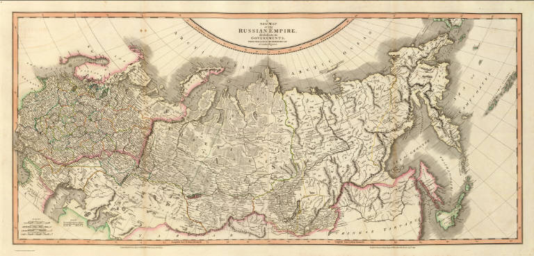
Author
Cary, John, ca. 1754-1835
Full Title
A new (map) of (the) Russian (Empire,) divided (into its) govern(ments;) from the latest (authorities, by) J. Cary, (engraver) (west sheet) London: Printed for J. Cary, Engraver & Map-seller, No. 181, Strand, Aug. 1st., 1799.
List No
1657.038
Note
Engraved map. Boundaries in outline hand col. Relief shown pictorially. Covers the Empire, west of 100oE. "37" pasted on verso.
Author
Cary, John, ca. 1754-1835
Full Title
(A new) map (of) the (Russian) Empire, (divided) into its (govern)ments; (from the latest) authorities, by (J. Cary,) engraver. (east sheet) London: Printed for J. Cary, Engraver & Map-seller, No. 181, Strand, Aug. 1st., 1799.
List No
1657.039
Note
Engraved map. Boundaries in outline hand col. Relief shown pictorially. Covers the Empire, east of 100oE. "38" pasted on verso.
Author
Cary, John, ca. 1754-1835
Full Title
(Composite of) A new map of the Russian Empire, divided into its governments; from the latest authorities, by J. Cary, engraver. London: Printed for J. Cary, Engraver & Map-seller, No. 181, Strand, Aug. 1st., 1799.
List No
1657.040
Note
Engraved map on 2 sheets. Boundaries in outline hand col. Relief shown pictorially. The numbers 37 and 38 pasted on versos.
Author
Faden, William, 1750?-1836
Full Title
The southeastern part of France which includes Roussillon-Languedoc, with a great portion of Rouergue and Auvergne-Provence-Dauphine, and the whole frontier of Italy. London, publish'd by Willm. Faden, Geographer to the King and to H.R.H. the Prince of Wales, Charing Cross, July 1st, 1799.
List No
2104.018
Note
Engraved map. Full hand col. Relief shown by hachures. Shows roads, etc. "18" on verso.
Author
Faden, William, 1750?-1836
Full Title
Nouvelle carte de la Suisse dans laquelle sont exactement distingues les treize cantons, leurs allies, et leurs sujets. Dressee sur les memoires les plus corrects et assujettie aux observations astronomiques. a Londre, chez W. Faden, Charing Cross, 1799. Printed for W. Faden ... as the Act directs.
List No
2104.029
Note
Engraved map. Outline hand col. Relief shown pictorially. Includes "Vue de la Vallee de Chamouny et des glaciers du Cote du Midi, prise de l'Eglise de Chamouny en 1742," "Section des principales montagnes a l'Est-sud-Est, et au Sud de Geneve telles qu'on les voit de la Plaine de cette ville," and descriptive text. Prime meridian: Ferro. "27" on verso.
Author
Faden, William, 1750?-1836
Full Title
A map of the Kingdom of Poland and Grand Dutchy of Lithuania including Samogitia and Curland, divided according to their dismemberments, with the Kingdom of Prussia. (with) Warszawa, Warsaw. By Willm. Faden, Geographer to the King, M DCC XCIX. London, published by W. Faden, Geographer to the King & to H.R.H. the Prince of Wales, Charing Cross, April 2d, 1799. 2d edition.
List No
2104.033
Note
Engraved map with small inset. Full hand col. Relief shown pictorially. Includes descriptive text with population figures. "31" on verso.
Author
Cary, John, ca. 1754-1835
Full Title
A new map of the Russian Empire, divided into its governments; from the latest authorities, by J. Cary, engraver. London, printed for J. Cary, engraver & mapseller, no. 181 Strand, Augst. 1, 1799.
List No
2104.039
Note
Engraved map on 2 sheets. Full hand col. Relief shown pictorially. David Rumsey Collection copy: mounted as 1 sheet. "37" on verso.
Author
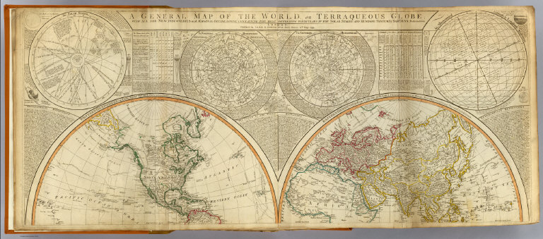
[Anville, Jean Baptiste Bourguignon d, 1697-1782, Dunn, Samuel, Robert Laurie & James Whittle]
Full Title
A general map of the World or terraqueous globe with all the new discoveries and marginal delineations, containing the most interesting particulars of the solar, starry and mundane system, by Saml. Dunn, mathematician. (North half). London, Published by Laurie & Whittle, No. 53, Fleet Street, 12th May, 1799.
List No
2310.002
Note
Hand colored engraved map. Relief shown pictorially. Contents: Western Hemisphere or the New World by Mr. d'Anville, with new discoveries and several additions -- Eastern Hemisphere or the Old World by Mr. d'Anville, with the new discoveries and several additions. Ancillary maps or charts: The Solar System -- The Northern Hemisphere -- The Southern Hemisphere -- An astronomical latitude & longitude analemma. Printed on 2 sheets; joined.
Author
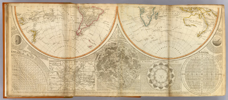
[Anville, Jean Baptiste Bourguignon d, 1697-1782, Dunn, Samuel, Riccioli, Giovanni Battista, Robert Laurie & James Whittle]
Full Title
(A general map of the World or terraqueous globe with all the new discoveries and marginal delineations, containing the most interesting particulars of the solar, starry and mundane system, by Saml. Dunn, mathematician. South half. London, Published by Laurie & Whittle, No. 53, Fleet Street, 12th May, 1799)
List No
2310.003
Note
Hand colored engraved map. Relief shown pictorially. Contents: Western Hemisphere or the New World by Mr. d'Anville, with new discoveries and several additions -- Eastern Hemisphere or the Old World by Mr. d'Anville, with the new discoveries and several additions. Ancillary maps or charts: An universal scale -- A chart of the World according to Mercator's projection, with the rhumb lines -- Selenography or A map of the Moon according to Father Riccioli -- The vicissitude of seasons explained -- The analemma. Printed on 2 sheets; joined.
Author
[Anville, Jean Baptiste Bourguignon d, 1697-1782, Dunn, Samuel, Riccioli, Giovanni Battista, Robert Laurie & James Whittle]
Full Title
(Composite of) A general map of the World or terraqueous globe with all the new discoveries and marginal delineations, containing the most interesting particulars of the solar, starry and mundane system, by Saml. Dunn, mathematician. London, Published by Laurie & Whittle, No. 53, Fleet Street, 12th May, 1799.
List No
2310.004
Note
Digital composite of north and south halves of hand colored engraved map. Relief shown pictorially. Contents: Western Hemisphere or the New World by Mr. d'Anville, with new discoveries and several additions -- Eastern Hemisphere or the Old World by Mr. d'Anville, with the new discoveries and several additions. Ancillary maps or charts: The Solar System -- The Northern Hemisphere -- The Southern Hemisphere -- An astronomical latitude & longitude analemma -- An universal scale -- A chart of the World according to Mercator's projection, with the rhumb lines -- Selenography or A map of the Moon according to Father Riccioli -- The vicissitude of seasons explained -- The analemma. Printed on 4 sheets; joined as 2.
Author
[Caroly, Francesco de, Robert Laurie & James Whittle]
Full Title
A new map of the dominions of the King of Sardinia. (with) Isle and kingdom of Sardinia. (with) Mont Blanc in Faucigni and the subjacent Alps and glaciers. From the original published at Turin with royal approbation, and dedicated to his Sardinian Majesty. By Francis de Caroly; translated with improvements and additions. London, Published by Laurie & Whittle, 53, Fleet Street, 12th May, 1799. Engrav'd by B. Baker, Islington.
List No
2310.031
Note
Hand colored engraved map with 2 insets. Relief shown pictorially.
Author
[Anville, Jean Baptiste Bourguignon d, 1697-1782, Robert Laurie & James Whittle]
Full Title
A new map of the middle and upper parts of Italy, wherein are included the State of the Church, the Grand Duchy of Tuscany; Austrian Lombardy; the states of Parma and Modena, and the republics of Venice, Genoa, Lucca &ca. with the island of Corsica. Drawn with many improvements and additions, from the general map of D'Anville &c. &c. Published 25th March 1799 by Robt. Laurie & Jas. Whittle, No. 53 Fleet Street, London. Jones & Smith sculp., 13 Pleasant Row, Pentonville.
List No
2310.032
Note
Hand colored engraved map. Relief shown pictorially.
Author
[Rizzi Zannoni, Giovanni Antonio Bartolomeo, 1736-1814, Robert Laurie & James Whittle]
Full Title
A new map of Sicily the First or the Kingdom of Naples. Drawn with several additions, from Zannoni's map published by order of the King of the Two Sicilies. Published 12th May, 1799 by Laurie & Whittle, 53, Fleet Street, London. Engraved by B. Baker, Islington.
List No
2310.033
Note
Hand colored engraved map. Relief shown pictorially. Shows cities, towns, archbishop's and bishop's sees, religious houses, castles, roads, rivers, etc. Ornamental cartouche.
Author
[Mylne, Robert, Robert Laurie & James Whittle]
Full Title
The island and Kingdom of Sicily, according to the best observations, & improved; from the map of the Baron de Schmettau, Quarter Master General to the Imperial Army ... ; from the map of Messrs. Don Co. Ventimiglio, and Ao. D'Aedone; and from Mr. Danville, and others. By Robert Mylne, F.R.S., on a journey in MDCCLVII. Published 12th May, 1799 by Laurie & Whittle, 53, Fleet Street, London.
List No
2310.034
Note
Hand colored engraved map. Relief shown by hachures. Includes the Lipari Islands.
Author
Robert Laurie & James Whittle
Full Title
A new map of the Kingdom of Poland, with its dismembered provinces and the Kingdm. of Prussia. London, Published 12th May 1799 by Laurie & Whittle, No. 53, Fleet Street.
List No
2310.048
Note
Hand colored engraved map. Relief shown pictorially.
Author
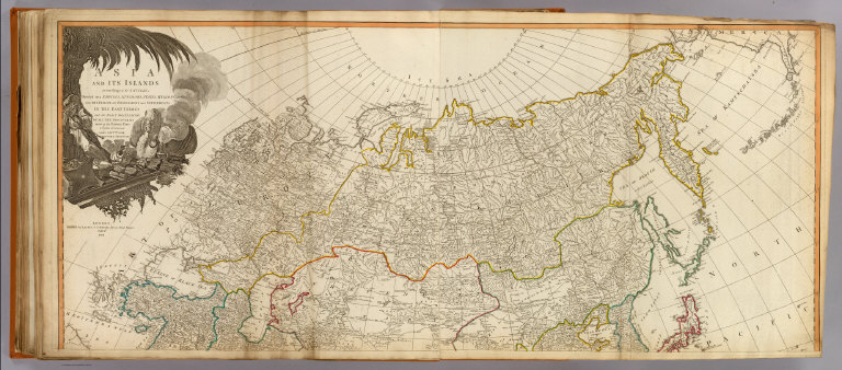
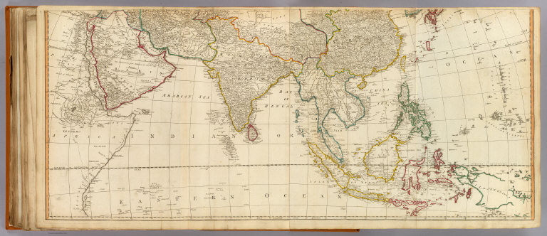
[Anville, Jean Baptiste Bourguignon d, 1697-1782, Robert Laurie & James Whittle]
Full Title
Asia and its islands according to d'Anville; divided into empires, kingdoms, states, regions, &c. &c. with the European possessions and settlements in the East Indies and an exact delineation of all the discoveries made in the eastern parts by the English under Captn. Cook, Vancouver & Peyrouse. (North sheets). London, Publish'd by Laurie & Whittle, No. 53, Fleet Street, Feby. 2d, 1799.
List No
2310.052
Note
Hand colored engraved map. Relief shown pictorially. Includes illustrated cartouche. Printed on 2 sheets; joined.
Full Title
(Asia and its islands according to d'Anville; divided into empires, kingdoms, states, regions, &c. &c. with the European possessions and settlements in the East Indies and an exact delineation of all the discoveries made in the eastern parts by the English under Captn. Cook, Vancouver & Peyrouse. Middle sheets. London, Publish'd by Laurie & Whittle, No. 53, Fleet Street, Feby. 2d, 1799)
List No
2310.053
Note
Hand colored engraved map. Relief shown pictorially. Printed on 2 sheets; joined.
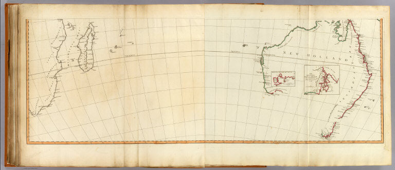
Full Title
(Asia and its islands according to d'Anville; divided into empires, kingdoms, states, regions, &c. &c. with the European possessions and settlements in the East Indies and an exact delineation of all the discoveries made in the eastern parts by the English under Captn. Cook, Vancouver & Peyrouse. South sheets. London, Publish'd by Laurie & Whittle, No. 53, Fleet Street, Feby. 2d, 1799)
List No
2310.054
Note
Digital composite of hand colored engraved map. Relief shown pictorially. Inset maps: Sketch of King Geo. IIIds Sound -- The discoveries made by the ship Duke on the south extremity of New Holland in 1791. Printed on 2 sheets; joined.
Author
[Anville, Jean Baptiste Bourguignon d, 1697-1782, Robert Laurie & James Whittle]
Full Title
(Composite of) Asia and its islands according to d'Anville; divided into empires, kingdoms, states, regions, &c. &c. with the European possessions and settlements in the East Indies and an exact delineation of all the discoveries made in the eastern parts by the English under Captn. Cook, Vancouver & Peyrouse. London, Publish'd by Laurie & Whittle, No. 53, Fleet Street, Feby. 2d, 1799.
List No
2310.055
Note
Digital composite of hand colored engraved map. Relief shown pictorially. Inset maps: Sketch of King Geo. IIIds Sound -- The discoveries made by the ship Duke on the south extremity of New Holland in 1791. Includes illustrated cartouche. Printed on 6 sheets; joined as 3.
1-78 of 78
|