|
Author
Duval, Henri (Henri Louis Nicolas), 1783-1854
Full Title
Tableau de physique et de météorologie. Par Henri Duval, Chevalier de la Légion-d'Honneur; Professeur d'Histoire, de Géographie, de Belles-Lettres, etc., etc. Delloye, Libraire, Place de la Bourse, No 13. Tous les Exemplaires ont le Timbre de l'Auteur. Imprimerie de Terzuolo, Successeur de M. Plassan, Rue de Vaugirard, No 11.
List No
14254.043
Note
Engraved, hand-colored view illustrating physical and meteorological phenomena, including the science of vision, color and lightning. Title translates to: Physics and meteorology table. Accompanied by descriptive text in tables within margins. With addresses in top corners: L'Auteur, Rue des Martyrs, no 23, Chaussée-d'Antin -- Adopté pour les maisons Royles d'Éducation de la Légion-d'Honneur. View is 18 x 19 cm, on sheet 42 x 61 cm. In third section: Sciences [= Science].
Author
Duval, Henri (Henri Louis Nicolas), 1783-1854
Full Title
Tableau de géologie et des révolutions du globe. Par Henri Duval, Chevalier de la Légion-d'Honneur; Professeur d'Histoire, de Géographie, de Belles-Lettres, etc., etc. Gravé par Laguillermie rue des Noyers No. 56. Delloye, Libraire, Place de la Bourse, No 13. Tous les Exemplaires ont le Timbre de l'Auteur. Imprimerie de Terzuolo, Successeur de M. Plassan, Rue de Vaugirard, No 11.
List No
14254.045
Note
Engraved, hand-colored view illustrating the tallest mountains from around the world, as well as volcanoes. Mountains indexed in association with a table giving peak heights. Title translates to: Table of geology and revolutions of the globe. Accompanied by descriptive text in tables within margins, covering geological phenomena, such as volcanoes, minerals and animal fossils. With addresses in top corners: L'Auteur, Rue des Martyrs, no 23, Chaussée-d'Antin -- Adopté pour les maisons Royles d'Éducation de la Légion-d'Honneur. View is 22 x 23 cm, on sheet 42 x 61 cm. In third section: Sciences [= Science].
Author
[Sydow, Emil von., 1812-1873, Wagner, Hermann, 1840-1929]
Full Title
Mitteleuropa Relief. Gotha : Justus Perthes. Sydow-Wagners method. Schul-Atlas. XXIII.
List No
13559.051
Note
Relief map of Central Europe. Vereinfachte Kegelprojektion. Includes inset map of Hamburg. Relief shown by gradient tints, hachures and spot height. Depth shown by bathymetric tints, isolines and sounding.
Author
[Sydow, Emil von., 1812-1873, Wagner, Hermann, 1840-1929]
Full Title
Europa : übersicht des relief. Gotha : Justus Perthes. Sydow-Wagners method. Schul-Atlas. XXI.
List No
13557.044
Note
Geologic map of Europe. Relief shown by gradient tints, hachures and spot heights. Depth shown by bathymetric tints, isolines and soundings. Bonnesche projektion.
Author
[Sydow, Emil von., 1812-1873, Wagner, Hermann, 1840-1929]
Full Title
Mitteleuropa : Relief. Gotha : Justus Perthes. Sydow-Wagners method. Schul-Atlas. XXI.
List No
13557.058
Note
Relief map of Central Europe. Vereinfachte Kegelprojektion. Includes inset map of Hamburg. Shows political boundaries. Relief shown by gradient tints, hachures and spot height. Depth shown by bathymetric tints, isolines and sounding.
Author
[Sydow, Emil von., 1812-1873, Wagner, Hermann, 1840-1929]
Full Title
Südwest- Deutschland. Gotha : Justus Perthes. Sydow-Wagners method. Schul-Atlas. XXI.
List No
13557.089
Note
Map of Southwestern Germany. Vereinfachte Kegelprojektion.
Author
[Sydow, Emil von., 1812-1873, Wagner, Hermann, 1840-1929]
Full Title
Schweizer Alpen. Gotha : Justus Perthes. Sydow-Wagners method. Schul-Atlas : 21 Auflage. 1940.
List No
13557.093
Note
Map of Swiss Alps. With inset maps: Bern and Zurich. Vereinfachte Kegelprojektion.
Author
[Sydow, Emil von., 1812-1873, Wagner, Hermann, 1840-1929]
Full Title
Ungarische Tiefebene und Karpaten. Gotha : Justus Perthes. Sydow-Wagners method. Schul-Atlas. XXI.
List No
13557.095
Note
Map of the Hungarian Plain and Carpatian Mountains. With inset map: Budapest. Vereinfachte Kegelprojektion.
Author
[Sydow, Emil von., 1812-1873, Wagner, Hermann, 1840-1929]
Full Title
Vorderasien und Agypten. Gotha : Justus Perthes. Sydow-Wagners method. Schul-Atlas : 21 Auflage. 1940.
List No
13557.121
Note
Map of Middle East and Egypt. With inset: Frz. Somali. Bonne'sche Projektion.
Author
[Sydow, Emil von., 1812-1873, Wagner, Hermann, 1840-1929]
Full Title
Sudamerika : Sonderkarten zur Landerkunde. Subtropisches Sudamerika. Gotha : Justus Perthes. Sydow-Wagners method. Schul-Atlas : 21 Auflage. 1940.
List No
13557.145
Note
Map of South America. With 6 insets, Showing Isotherm, precipitation, economy, roads and transportation. Bonne'sche Projektion.
Author
Reynolds, James, 1817-1876
Full Title
Physical features of the land. Published by James Reynolds, 174 Strand, London.
List No
14338.003
Note
World map showing physical geography around the globe. Features mountain chains, peaks, plateaus ("table lands"), plains, valleys, lowlands, vegetation, deserts, drainage, coastlines and islands. Relief shown with hachures. Includes latitudinal and longitudinal lines, as well as a legend and explanatory notes throughout. Colored engraving double plate. Map is 43 x 69 cm, on sheet 51 x 77 cm. Descriptive notes in accompanying booklet preceding maps.
Author
[Baranov, Anatolij Nikolaevič, Soviet Union. Glavnoe upravlenie geodezii i kartografii]
Full Title
Fizicheskaia karta Mira. 1-2. Atlas Mira : 1954.
List No
13682.015
Note
Double hemisphere physical folded map of the world. Elevation shown by hypsometric tints and spot heights.
Author
[Baranov, Anatolij Nikolaevič, Soviet Union. Glavnoe upravlenie geodezii i kartografii]
Full Title
Soiuz Sovetskikh Sotsialisticheskikh Respublik : Fizicheskaia karta. 9-10. Atlas Mira : 1954.
List No
13682.022
Note
Physical map of the USSR. Relief shown by shading, gradient tints, and spot heights; Depths by Depths by bathymetric tints, isolines and soundings. Includes Great Circle nautical Scale and color coded reference.
Author
[Baranov, Anatolij Nikolaevič, Soviet Union. Glavnoe upravlenie geodezii i kartografii]
Full Title
Средняя азия (Восток) = Sredniaia Aziia (Vostok). 61-62. Atlas Mira : 1954.
List No
13682.075
Note
Physical map of Central East Asia. Relief shown by gradient tints, contours and spotlights. Depth shown by bathymetric tints, isolines and soundings.
Author
[Baranov, Anatolij Nikolaevič, Soviet Union. Glavnoe upravlenie geodezii i kartografii]
Full Title
Прибайкалье и Забайкалье = Pribaykal'ye i Zabaykal'ye. 73-74. Atlas Mira : 1954.
List No
13682.087
Note
Physical map of the Trans-Baikal Territory is part of the Siberian Federal District. Relief shown by gradient tints, contours and spotlights. Depth shown by bathymetric tints, isolines and soundings.
Author
[Baranov, Anatolij Nikolaevič, Soviet Union. Glavnoe upravlenie geodezii i kartografii]
Full Title
Европа, Физическая карта = Evropa, Fizicheskaia karta. 85-86. Atlas Mira : 1954.
List No
13682.099
Note
Physical map of Europe. Relief shown by gradient tints, contours and spotlights. Depth shown by bathymetric tints, isolines and soundings.
Author
[Baranov, Anatolij Nikolaevič, Soviet Union. Glavnoe upravlenie geodezii i kartografii]
Full Title
Северная италия, Свободная Территория Триест, Швейцария = Severnaia Italiia, Svobodnaia Territoriia Triyest, Shveytsariia. 115-116. Atlas Mira : 1954.
List No
13682.129
Note
Physical map of Northern Italy, Free Territory of Trieste and Switzerland. Showing political boundaries. Relief shown by gradient tints, contours and spot heights. Depth shown by bathymetric tints, isolines and soundings.
Author
[Baranov, Anatolij Nikolaevič, Soviet Union. Glavnoe upravlenie geodezii i kartografii]
Full Title
Азия = Aziia. 138-139. Atlas Mira : 1954.
List No
13682.152
Note
Physical map of Asia. Showing political boundaries. Relief shown by gradient tints, contours and spot heights. Depth shown by bathymetric tints, isolines and soundings.
Author
[Baranov, Anatolij Nikolaevič, Soviet Union. Glavnoe upravlenie geodezii i kartografii]
Full Title
Западный Китай = Zapadnyy Kitay. 156-157. Atlas Mira : 1954.
List No
13682.170
Note
Physical map of Western China. Relief shown by gradient tints, contours and spot heights. Depth shown by bathymetric tints, isolines and soundings.
Author
[3, Soviet Union. Glavnoe upravlenie geodezii i kartografii]
Full Title
Африка, Физическая = Afrika, Fizicheskaia. 191-192. Atlas Mira : 1954.
List No
13682.205
Note
Physical map of Africa. Relief shown by gradient tints, contours and spot heights. Depths shown by gradient tints, isolines and soundings.
Author
[3, Soviet Union. Glavnoe upravlenie geodezii i kartografii]
Full Title
Соединенные Штаты Америки = Soyedinennye Shtaty Ameriki. 227-228. Atlas Mira : 1954.
List No
13682.241
Note
Physical map of the United States. Relief shown by shadings and spot heights. Depths shown by gradient tints, isolines and soundings.
Author
[3, Soviet Union. Glavnoe upravlenie geodezii i kartografii]
Full Title
Запад США = Zapad SShA. 242-243. Atlas Mira : 1954.
List No
13682.256
Note
Physical map of the West of the United States. Showing state boundaries. Relief shown by shadings, contours and spot heights. Depths shown by gradient tints, isolines and soundings.
Author
[3, Soviet Union. Glavnoe upravlenie geodezii i kartografii]
Full Title
Атлантический Океан = Atlanticheskiy Okean. 278-279. Atlas Mira : 1954.
List No
13682.292
Note
Map of the Atlantic Ocean. Showing ocean currents, shipping and exploration routes. Relief shown by gradient tints and spot heights. Depths shown by bathymetric tints, isolines and soundings.
Author
Silishchensky, Mitrofan Ivanovich 1878 - 1944
Full Title
(Title Page to) Geograficheskiy atlas Chast 1. Sostavil Prof. M. I. Silishchenskiy pod redaktsiyey N. N. Baranskogo i V. A. Kamenetskogo. Aktsionernoye obshchestvo "Sovetskaya entsiklopediya" Moskva, 1929.
List No
13461.014
Note
Second title page with physical map of the world.
Author
Silishchensky, Mitrofan Ivanovich 1878 - 1944
Full Title
Velikiy Tikhiy Okean. Fizicheskaya i ekonomicheskaya karta. Prof. M. I. Silishchenskiy. Gos. Kart Inst. NTU-VSNKH-SSR. Kartograiya Leningrad. (to accompany) Geograficheskiy atlas Chast 1.
List No
13461.016
Note
Physical and economical map of Pacific Ocean. Includes legend and table to map symbols. Depth shown by bathymetric tints, isolines and soundings.
Author
Silishchensky, Mitrofan Ivanovich 1878 - 1944
Full Title
Indiyskiy Okean. Ekonomicheskaya i Fizicheskaya karta. Prof. M. I. Silishchenskiy. Gos. Kartogr. Institut NTU-VSNKH-SSR. Kartografiya Leningrad. (to accompany) Geograficheskiy atlas Chast 1.
List No
13461.017
Note
Physical and economical map of Indian Ocean. Includes profile of India ocean. Includes legend and table to map symbols.
Author
Abdulqader, M.
Full Title
Eawarid tabeia ... kharita = Map of natural geographical features. (to accompany) Küçük Coğrafya = (School atlas of geography). ikinci kisim. Murtabi M. Abdulqader. 1325 (1907).
List No
13530.006
Note
Color map. Showing geographical landscape in the form of mountains, rivers, valleys, canyon, lake, sea, island, peninsula, lagoon, etc.
Author
Abdulqader, M.
Full Title
Avrupa : 'ahwal tabia ve siyasi = Europe : Physical and political conditions. (to accompany) Küçük Coğrafya = (School atlas of geography). ikinci kisim. Murtabi M. Abdulqader. 1325 (1907).
List No
13530.009
Note
Color political and physical map of Europe, with inset of location map. Shows political boundaries, major cities , capitals, rivers and mountains. Relief shown by hachures. Includes flags of various European counties.
Author
Abdulqader, M.
Full Title
Avrupa İ Osmanî = European Dominions of the Ottomans. (to accompany) Küçük Coğrafya = (School atlas of geography). ikinci kisim. Murtabi M. Abdulqader. 1325 (1907).
List No
13530.011
Note
Color map of Ottoman Empire or Turkey in Europe. Shows political boundaries, major cities, rivers and mountains. Relief shown by hachures. Includes vignettes illustration of traditional costumes and Turkish flag.
Author
Abdulqader, M.
Full Title
Asya = Asia. (to accompany) Küçük Coğrafya = (School atlas of geography). ikinci kisim. Murtabi M. Abdulqader. 1325 (1907).
List No
13530.013
Note
Color map of Asia Shows political boundaries, major cities, rivers and mountains. Relief shown by hachures. Includes vignettes of flags of various Asian countries.
Author
Abdulqader, M.
Full Title
Asya i Osmanî : Anatuli = Ottoman Dominions in Asia : Anatoli. (to accompany) Küçük Coğrafya = (School atlas of geography). ikinci kisim. Murtabi M. Abdulqader. 1325 (1907).
List No
13530.015
Note
Color map of Ottoman Empire in Asia or Asia Minor. Shows political boundaries, major cities, rivers and mountains. Relief shown by hachures. Includes vignettes illustration of traditional costumes and Turkish flag.
Author
Abdulqader, M.
Full Title
Afrika = Africa. (to accompany) Küçük Coğrafya = (School atlas of geography). ikinci kisim. Murtabi M. Abdulqader. 1325 (1907).
List No
13530.017
Note
Color map of Africa. Shows political boundaries, major cities, rivers and mountains. Relief shown by hachures. Includes vignettes of flags of various African countries.
Author
Abdulqader, M.
Full Title
(Text Page to) Afrika-i Osmanî.ve Arabistan = Ottoman Empire in Africa and Arabia. (to accompany) Küçük Coğrafya = (School atlas of geography). ikinci kisim. Murtabi M. Abdulqader. 1325 (1907).
List No
13530.018
Note
Descriptive text to Ottoman Empire in Africa and Arabia.
Author
Schonberg & Co.
Full Title
The Principal Mountains and Rivers of the World compiled from the Latest Authorities. New York. Schonberg & Co. 1864.
List No
4324.004
Note
Shows lengths of major rivers and heights of mountains; differentiated by hemisphere.
Author
[Gorkin, Aleksandr Fedorovich, Motylev, V.E.]
Full Title
Fiziko-geograficheskie karti okeanov. (to accompany) Bolshoi Sovietskii Atlas Mira. Moskva 1937.
List No
11008.026
Note
10 color Physiographic map of the Atlantic and Pacific Oceans on 2 sheets. Includes legend. Depth shown by isolines and soundings. Showing ocean current, depths, temperature, etc.
Author
[Gorkin, Aleksandr Fedorovich, Motylev, V.E.]
Full Title
Arktiki. (on upper margin) Arktika. (9 insets). (to accompany) Bolshoi Sovietskii Atlas Mira. Moskva 1937.
List No
11008.028
Note
Color map of the Arctic region with 9 insets, on 2 sheets. Includes legend. Relief shown by gradient tints and spot heights. Depth shown by isolines and soundings.
Author
[Gorkin, Aleksandr Fedorovich, Motylev, V.E.]
Full Title
Relef Soiuza SSR (profili). (to accompany) Bolshoi Sovietskii Atlas Mira. Moskva 1937.
List No
11008.101
Note
Color relief profile of the Soviet Union. Relief shown gradient tints and spot heights. Includes charts and reference.
Author
Rand McNally and Company
Full Title
Relief Map of North America.
List No
2790.009
Author
Meyer, Joseph, 1796-1856
Full Title
Physikalische Karte vom Indischen Meere. Stahlstich (Direction v. Kleinknecht) aus der Schweinfurter Geographischen Graviranstalt des Bibliographischen Instituts zu Hildburghausen, Amsterdam, Paris u. Philadelphia. (in upper margin) Meyer's Zeitung Atlas. No. 99. (to accompany) Neuester Zeitungs-Atlas fur Alte und Neue Erdkunde. Herausgegeben von J. Meyer.
List No
11652.126
Note
Engraved hand color map of the Indian Ocean. Showing currents, temperatures, trading routes and explorers' tracks. Includes notes. Depth shown by isolines and soundings. Prime meridian is Paris.
Author
Marmocchi, Francesco Constantino, 1805-1858
Full Title
Geografia Fisica. Rosa di 32 Venti con i Loro Nomi Greci, Latini, Italiani, ed Oltramontani. Studio Giarre. (to accompany) Atlante di geografia universale ... Di F.C. Marmocchi. Firenze : per Vincenzo Batelli e Compagni 1842.
List No
11713.061
Note
Engraved hand colored diagram of the Rose of 32 winds with their names Greeks, Latinos, Italians, and Oltremontans. Includes notes.
Author
Schlieben, Wilhelm Ernst August von (1781 - 1839)
Full Title
Asien.
List No
12250.002
Author
Schlieben, Wilhelm Ernst August von (1781 - 1839)
Full Title
Africa.
List No
12250.003
Author
Schlieben, Wilhelm Ernst August von (1781 - 1839)
Full Title
Nordamerika und Westindien.
List No
12250.004
Author
Schlieben, Wilhelm Ernst August von (1781 - 1839)
Full Title
Suedamerika.
List No
12250.005
Author
Schlieben, Wilhelm Ernst August von (1781 - 1839)
Full Title
Australien.
List No
12250.006
Author
Brue, Adrien Hubert, 1786-1832
Full Title
Mappemonde physique sur la projection de Mercator, par A.H. Brue, Geographe de S.A.R. Monsieur. A Paris, Chez l'Auteur, rue des Macons-Sorbonne, no. 9, et chez les principaux marchands de geographie. Mars 1821.
List No
0096.015
Note
Hand colored engraved map. Relief shown by hachures. Prime meridian: Paris.
Author
Brue, Adrien Hubert, 1786-1832
Full Title
Carte physique et routiere de la France, de la Suisse, et d'une partie des etats limitrophes par A. Brue, Geographe du Roi. Paris, 1827. Chez l'Auteur, rue des Macons-Sorbonne, no. 9, et chez les principaux m(archan)ds de cartes geographiques.
List No
0096.028
Note
Hand colored engraved map. Relief shown by hachures. Prime meridian: Paris. Shows canals, bishoprics, archbishoprics, forts, mineral baths, etc. Includes inset maps of Corsica and "Environs de Paris a la distance de 12 lieues." Originally issued in 2 sheets.
Author
Brue, Adrien Hubert, 1786-1832
Full Title
Carte generale physique et routiere des 22 cantons de la Confederation Suisse, par A.H. Brue, Geographe de S.A.R. Monsieur. A Paris, Chez l'Auteur, rue des Macons-Sorbonne, no. 9, et chez les principaux marchands de geographie. Aout 1822.
List No
0096.029
Note
Hand colored engraved map. Relief shown by hachures. Prime meridian: Paris.
Author
Brue, Adrien Hubert, 1786-1832
Full Title
Carte generale physique et routiere de la Monarchie Autrichienne dressee par A. Brue, Geographe du Roi. Paris, 1827. Chez l'Auteur, rue des Macons-Sorbonne, no. 9, et chez les principaux m(archan)ds de cartes geographiques.
List No
0096.034
Note
Hand colored engraved map. Relief shown by hachures. Prime meridian: Paris.
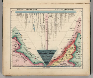
Author
Colton, G.W.
Full Title
Western Hemisphere. Eastern Hemisphere. Published by J. H. Colton. No. 172 William St. New York.
List No
0151.014
Note
Map showing Western and Eastern Hemisphere. Prime meridian is Greenwich.
|