|
Author
Duval, Henri (Henri Louis Nicolas), 1783-1854
Full Title
Tableau de physique et de météorologie. Par Henri Duval, Chevalier de la Légion-d'Honneur; Professeur d'Histoire, de Géographie, de Belles-Lettres, etc., etc. Delloye, Libraire, Place de la Bourse, No 13. Tous les Exemplaires ont le Timbre de l'Auteur. Imprimerie de Terzuolo, Successeur de M. Plassan, Rue de Vaugirard, No 11.
List No
14254.043
Note
Engraved, hand-colored view illustrating physical and meteorological phenomena, including the science of vision, color and lightning. Title translates to: Physics and meteorology table. Accompanied by descriptive text in tables within margins. With addresses in top corners: L'Auteur, Rue des Martyrs, no 23, Chaussée-d'Antin -- Adopté pour les maisons Royles d'Éducation de la Légion-d'Honneur. View is 18 x 19 cm, on sheet 42 x 61 cm. In third section: Sciences [= Science].
Author
Duval, Henri (Henri Louis Nicolas), 1783-1854
Full Title
Tableau de géologie et des révolutions du globe. Par Henri Duval, Chevalier de la Légion-d'Honneur; Professeur d'Histoire, de Géographie, de Belles-Lettres, etc., etc. Gravé par Laguillermie rue des Noyers No. 56. Delloye, Libraire, Place de la Bourse, No 13. Tous les Exemplaires ont le Timbre de l'Auteur. Imprimerie de Terzuolo, Successeur de M. Plassan, Rue de Vaugirard, No 11.
List No
14254.045
Note
Engraved, hand-colored view illustrating the tallest mountains from around the world, as well as volcanoes. Mountains indexed in association with a table giving peak heights. Title translates to: Table of geology and revolutions of the globe. Accompanied by descriptive text in tables within margins, covering geological phenomena, such as volcanoes, minerals and animal fossils. With addresses in top corners: L'Auteur, Rue des Martyrs, no 23, Chaussée-d'Antin -- Adopté pour les maisons Royles d'Éducation de la Légion-d'Honneur. View is 22 x 23 cm, on sheet 42 x 61 cm. In third section: Sciences [= Science].
Author
[Sydow, Emil von., 1812-1873, Wagner, Hermann, 1840-1929]
Full Title
Mitteleuropa Relief. Gotha : Justus Perthes. Sydow-Wagners method. Schul-Atlas. XXIII.
List No
13559.051
Note
Relief map of Central Europe. Vereinfachte Kegelprojektion. Includes inset map of Hamburg. Relief shown by gradient tints, hachures and spot height. Depth shown by bathymetric tints, isolines and sounding.
Author
[Sydow, Emil von., 1812-1873, Wagner, Hermann, 1840-1929]
Full Title
Europa : übersicht des relief. Gotha : Justus Perthes. Sydow-Wagners method. Schul-Atlas. XXI.
List No
13557.044
Note
Geologic map of Europe. Relief shown by gradient tints, hachures and spot heights. Depth shown by bathymetric tints, isolines and soundings. Bonnesche projektion.
Author
[Sydow, Emil von., 1812-1873, Wagner, Hermann, 1840-1929]
Full Title
Mitteleuropa : Relief. Gotha : Justus Perthes. Sydow-Wagners method. Schul-Atlas. XXI.
List No
13557.058
Note
Relief map of Central Europe. Vereinfachte Kegelprojektion. Includes inset map of Hamburg. Shows political boundaries. Relief shown by gradient tints, hachures and spot height. Depth shown by bathymetric tints, isolines and sounding.
Author
[Sydow, Emil von., 1812-1873, Wagner, Hermann, 1840-1929]
Full Title
Südwest- Deutschland. Gotha : Justus Perthes. Sydow-Wagners method. Schul-Atlas. XXI.
List No
13557.089
Note
Map of Southwestern Germany. Vereinfachte Kegelprojektion.
Author
[Sydow, Emil von., 1812-1873, Wagner, Hermann, 1840-1929]
Full Title
Schweizer Alpen. Gotha : Justus Perthes. Sydow-Wagners method. Schul-Atlas : 21 Auflage. 1940.
List No
13557.093
Note
Map of Swiss Alps. With inset maps: Bern and Zurich. Vereinfachte Kegelprojektion.
Author
[Sydow, Emil von., 1812-1873, Wagner, Hermann, 1840-1929]
Full Title
Ungarische Tiefebene und Karpaten. Gotha : Justus Perthes. Sydow-Wagners method. Schul-Atlas. XXI.
List No
13557.095
Note
Map of the Hungarian Plain and Carpatian Mountains. With inset map: Budapest. Vereinfachte Kegelprojektion.
Author
[Sydow, Emil von., 1812-1873, Wagner, Hermann, 1840-1929]
Full Title
Vorderasien und Agypten. Gotha : Justus Perthes. Sydow-Wagners method. Schul-Atlas : 21 Auflage. 1940.
List No
13557.121
Note
Map of Middle East and Egypt. With inset: Frz. Somali. Bonne'sche Projektion.
Author
[Sydow, Emil von., 1812-1873, Wagner, Hermann, 1840-1929]
Full Title
Sudamerika : Sonderkarten zur Landerkunde. Subtropisches Sudamerika. Gotha : Justus Perthes. Sydow-Wagners method. Schul-Atlas : 21 Auflage. 1940.
List No
13557.145
Note
Map of South America. With 6 insets, Showing Isotherm, precipitation, economy, roads and transportation. Bonne'sche Projektion.
Author
Reynolds, James, 1817-1876
Full Title
Physical features of the land. Published by James Reynolds, 174 Strand, London.
List No
14338.003
Note
World map showing physical geography around the globe. Features mountain chains, peaks, plateaus ("table lands"), plains, valleys, lowlands, vegetation, deserts, drainage, coastlines and islands. Relief shown with hachures. Includes latitudinal and longitudinal lines, as well as a legend and explanatory notes throughout. Colored engraving double plate. Map is 43 x 69 cm, on sheet 51 x 77 cm. Descriptive notes in accompanying booklet preceding maps.
Author
[Baranov, Anatolij Nikolaevič, Soviet Union. Glavnoe upravlenie geodezii i kartografii]
Full Title
Fizicheskaia karta Mira. 1-2. Atlas Mira : 1954.
List No
13682.015
Note
Double hemisphere physical folded map of the world. Elevation shown by hypsometric tints and spot heights.
Author
[Baranov, Anatolij Nikolaevič, Soviet Union. Glavnoe upravlenie geodezii i kartografii]
Full Title
Soiuz Sovetskikh Sotsialisticheskikh Respublik : Fizicheskaia karta. 9-10. Atlas Mira : 1954.
List No
13682.022
Note
Physical map of the USSR. Relief shown by shading, gradient tints, and spot heights; Depths by Depths by bathymetric tints, isolines and soundings. Includes Great Circle nautical Scale and color coded reference.
Author
[Baranov, Anatolij Nikolaevič, Soviet Union. Glavnoe upravlenie geodezii i kartografii]
Full Title
Средняя азия (Восток) = Sredniaia Aziia (Vostok). 61-62. Atlas Mira : 1954.
List No
13682.075
Note
Physical map of Central East Asia. Relief shown by gradient tints, contours and spotlights. Depth shown by bathymetric tints, isolines and soundings.
Author
[Baranov, Anatolij Nikolaevič, Soviet Union. Glavnoe upravlenie geodezii i kartografii]
Full Title
Прибайкалье и Забайкалье = Pribaykal'ye i Zabaykal'ye. 73-74. Atlas Mira : 1954.
List No
13682.087
Note
Physical map of the Trans-Baikal Territory is part of the Siberian Federal District. Relief shown by gradient tints, contours and spotlights. Depth shown by bathymetric tints, isolines and soundings.
Author
[Baranov, Anatolij Nikolaevič, Soviet Union. Glavnoe upravlenie geodezii i kartografii]
Full Title
Европа, Физическая карта = Evropa, Fizicheskaia karta. 85-86. Atlas Mira : 1954.
List No
13682.099
Note
Physical map of Europe. Relief shown by gradient tints, contours and spotlights. Depth shown by bathymetric tints, isolines and soundings.
Author
[Baranov, Anatolij Nikolaevič, Soviet Union. Glavnoe upravlenie geodezii i kartografii]
Full Title
Северная италия, Свободная Территория Триест, Швейцария = Severnaia Italiia, Svobodnaia Territoriia Triyest, Shveytsariia. 115-116. Atlas Mira : 1954.
List No
13682.129
Note
Physical map of Northern Italy, Free Territory of Trieste and Switzerland. Showing political boundaries. Relief shown by gradient tints, contours and spot heights. Depth shown by bathymetric tints, isolines and soundings.
Author
[Baranov, Anatolij Nikolaevič, Soviet Union. Glavnoe upravlenie geodezii i kartografii]
Full Title
Азия = Aziia. 138-139. Atlas Mira : 1954.
List No
13682.152
Note
Physical map of Asia. Showing political boundaries. Relief shown by gradient tints, contours and spot heights. Depth shown by bathymetric tints, isolines and soundings.
Author
[Baranov, Anatolij Nikolaevič, Soviet Union. Glavnoe upravlenie geodezii i kartografii]
Full Title
Западный Китай = Zapadnyy Kitay. 156-157. Atlas Mira : 1954.
List No
13682.170
Note
Physical map of Western China. Relief shown by gradient tints, contours and spot heights. Depth shown by bathymetric tints, isolines and soundings.
Author
[3, Soviet Union. Glavnoe upravlenie geodezii i kartografii]
Full Title
Африка, Физическая = Afrika, Fizicheskaia. 191-192. Atlas Mira : 1954.
List No
13682.205
Note
Physical map of Africa. Relief shown by gradient tints, contours and spot heights. Depths shown by gradient tints, isolines and soundings.
Author
[3, Soviet Union. Glavnoe upravlenie geodezii i kartografii]
Full Title
Соединенные Штаты Америки = Soyedinennye Shtaty Ameriki. 227-228. Atlas Mira : 1954.
List No
13682.241
Note
Physical map of the United States. Relief shown by shadings and spot heights. Depths shown by gradient tints, isolines and soundings.
Author
[3, Soviet Union. Glavnoe upravlenie geodezii i kartografii]
Full Title
Запад США = Zapad SShA. 242-243. Atlas Mira : 1954.
List No
13682.256
Note
Physical map of the West of the United States. Showing state boundaries. Relief shown by shadings, contours and spot heights. Depths shown by gradient tints, isolines and soundings.
Author
[3, Soviet Union. Glavnoe upravlenie geodezii i kartografii]
Full Title
Атлантический Океан = Atlanticheskiy Okean. 278-279. Atlas Mira : 1954.
List No
13682.292
Note
Map of the Atlantic Ocean. Showing ocean currents, shipping and exploration routes. Relief shown by gradient tints and spot heights. Depths shown by bathymetric tints, isolines and soundings.
Author
Silishchensky, Mitrofan Ivanovich 1878 - 1944
Full Title
(Title Page to) Geograficheskiy atlas Chast 1. Sostavil Prof. M. I. Silishchenskiy pod redaktsiyey N. N. Baranskogo i V. A. Kamenetskogo. Aktsionernoye obshchestvo "Sovetskaya entsiklopediya" Moskva, 1929.
List No
13461.014
Note
Second title page with physical map of the world.
Author
Silishchensky, Mitrofan Ivanovich 1878 - 1944
Full Title
Velikiy Tikhiy Okean. Fizicheskaya i ekonomicheskaya karta. Prof. M. I. Silishchenskiy. Gos. Kart Inst. NTU-VSNKH-SSR. Kartograiya Leningrad. (to accompany) Geograficheskiy atlas Chast 1.
List No
13461.016
Note
Physical and economical map of Pacific Ocean. Includes legend and table to map symbols. Depth shown by bathymetric tints, isolines and soundings.
Author
Silishchensky, Mitrofan Ivanovich 1878 - 1944
Full Title
Indiyskiy Okean. Ekonomicheskaya i Fizicheskaya karta. Prof. M. I. Silishchenskiy. Gos. Kartogr. Institut NTU-VSNKH-SSR. Kartografiya Leningrad. (to accompany) Geograficheskiy atlas Chast 1.
List No
13461.017
Note
Physical and economical map of Indian Ocean. Includes profile of India ocean. Includes legend and table to map symbols.
Author
Abdulqader, M.
Full Title
Eawarid tabeia ... kharita = Map of natural geographical features. (to accompany) Küçük Coğrafya = (School atlas of geography). ikinci kisim. Murtabi M. Abdulqader. 1325 (1907).
List No
13530.006
Note
Color map. Showing geographical landscape in the form of mountains, rivers, valleys, canyon, lake, sea, island, peninsula, lagoon, etc.
Author
Abdulqader, M.
Full Title
Avrupa : 'ahwal tabia ve siyasi = Europe : Physical and political conditions. (to accompany) Küçük Coğrafya = (School atlas of geography). ikinci kisim. Murtabi M. Abdulqader. 1325 (1907).
List No
13530.009
Note
Color political and physical map of Europe, with inset of location map. Shows political boundaries, major cities , capitals, rivers and mountains. Relief shown by hachures. Includes flags of various European counties.
Author
Abdulqader, M.
Full Title
Avrupa İ Osmanî = European Dominions of the Ottomans. (to accompany) Küçük Coğrafya = (School atlas of geography). ikinci kisim. Murtabi M. Abdulqader. 1325 (1907).
List No
13530.011
Note
Color map of Ottoman Empire or Turkey in Europe. Shows political boundaries, major cities, rivers and mountains. Relief shown by hachures. Includes vignettes illustration of traditional costumes and Turkish flag.
Author
Abdulqader, M.
Full Title
Asya = Asia. (to accompany) Küçük Coğrafya = (School atlas of geography). ikinci kisim. Murtabi M. Abdulqader. 1325 (1907).
List No
13530.013
Note
Color map of Asia Shows political boundaries, major cities, rivers and mountains. Relief shown by hachures. Includes vignettes of flags of various Asian countries.
Author
Abdulqader, M.
Full Title
Asya i Osmanî : Anatuli = Ottoman Dominions in Asia : Anatoli. (to accompany) Küçük Coğrafya = (School atlas of geography). ikinci kisim. Murtabi M. Abdulqader. 1325 (1907).
List No
13530.015
Note
Color map of Ottoman Empire in Asia or Asia Minor. Shows political boundaries, major cities, rivers and mountains. Relief shown by hachures. Includes vignettes illustration of traditional costumes and Turkish flag.
Author
Abdulqader, M.
Full Title
Afrika = Africa. (to accompany) Küçük Coğrafya = (School atlas of geography). ikinci kisim. Murtabi M. Abdulqader. 1325 (1907).
List No
13530.017
Note
Color map of Africa. Shows political boundaries, major cities, rivers and mountains. Relief shown by hachures. Includes vignettes of flags of various African countries.
Author
Abdulqader, M.
Full Title
(Text Page to) Afrika-i Osmanî.ve Arabistan = Ottoman Empire in Africa and Arabia. (to accompany) Küçük Coğrafya = (School atlas of geography). ikinci kisim. Murtabi M. Abdulqader. 1325 (1907).
List No
13530.018
Note
Descriptive text to Ottoman Empire in Africa and Arabia.
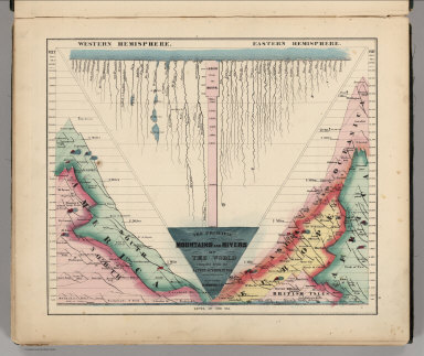
Author
Schonberg & Co.
Full Title
The Principal Mountains and Rivers of the World compiled from the Latest Authorities. New York. Schonberg & Co. 1864.
List No
4324.004
Note
Shows lengths of major rivers and heights of mountains; differentiated by hemisphere.
Author
[Gorkin, Aleksandr Fedorovich, Motylev, V.E.]
Full Title
Fiziko-geograficheskie karti okeanov. (to accompany) Bolshoi Sovietskii Atlas Mira. Moskva 1937.
List No
11008.026
Note
10 color Physiographic map of the Atlantic and Pacific Oceans on 2 sheets. Includes legend. Depth shown by isolines and soundings. Showing ocean current, depths, temperature, etc.
Author
[Gorkin, Aleksandr Fedorovich, Motylev, V.E.]
Full Title
Arktiki. (on upper margin) Arktika. (9 insets). (to accompany) Bolshoi Sovietskii Atlas Mira. Moskva 1937.
List No
11008.028
Note
Color map of the Arctic region with 9 insets, on 2 sheets. Includes legend. Relief shown by gradient tints and spot heights. Depth shown by isolines and soundings.
Author
[Gorkin, Aleksandr Fedorovich, Motylev, V.E.]
Full Title
Relef Soiuza SSR (profili). (to accompany) Bolshoi Sovietskii Atlas Mira. Moskva 1937.
List No
11008.101
Note
Color relief profile of the Soviet Union. Relief shown gradient tints and spot heights. Includes charts and reference.
Author
Rand McNally and Company
Full Title
Relief Map of North America.
List No
2790.009
Author
Meyer, Joseph, 1796-1856
Full Title
Physikalische Karte vom Indischen Meere. Stahlstich (Direction v. Kleinknecht) aus der Schweinfurter Geographischen Graviranstalt des Bibliographischen Instituts zu Hildburghausen, Amsterdam, Paris u. Philadelphia. (in upper margin) Meyer's Zeitung Atlas. No. 99. (to accompany) Neuester Zeitungs-Atlas fur Alte und Neue Erdkunde. Herausgegeben von J. Meyer.
List No
11652.126
Note
Engraved hand color map of the Indian Ocean. Showing currents, temperatures, trading routes and explorers' tracks. Includes notes. Depth shown by isolines and soundings. Prime meridian is Paris.
Author
Marmocchi, Francesco Constantino, 1805-1858
Full Title
Geografia Fisica. Rosa di 32 Venti con i Loro Nomi Greci, Latini, Italiani, ed Oltramontani. Studio Giarre. (to accompany) Atlante di geografia universale ... Di F.C. Marmocchi. Firenze : per Vincenzo Batelli e Compagni 1842.
List No
11713.061
Note
Engraved hand colored diagram of the Rose of 32 winds with their names Greeks, Latinos, Italians, and Oltremontans. Includes notes.
Author
Schlieben, Wilhelm Ernst August von (1781 - 1839)
Full Title
Asien.
List No
12250.002
Author
Schlieben, Wilhelm Ernst August von (1781 - 1839)
Full Title
Africa.
List No
12250.003
Author
Schlieben, Wilhelm Ernst August von (1781 - 1839)
Full Title
Nordamerika und Westindien.
List No
12250.004
Author
Schlieben, Wilhelm Ernst August von (1781 - 1839)
Full Title
Suedamerika.
List No
12250.005
Author
Schlieben, Wilhelm Ernst August von (1781 - 1839)
Full Title
Australien.
List No
12250.006
Author
Brue, Adrien Hubert, 1786-1832
Full Title
Mappemonde physique sur la projection de Mercator, par A.H. Brue, Geographe de S.A.R. Monsieur. A Paris, Chez l'Auteur, rue des Macons-Sorbonne, no. 9, et chez les principaux marchands de geographie. Mars 1821.
List No
0096.015
Note
Hand colored engraved map. Relief shown by hachures. Prime meridian: Paris.
Author
Brue, Adrien Hubert, 1786-1832
Full Title
Carte physique et routiere de la France, de la Suisse, et d'une partie des etats limitrophes par A. Brue, Geographe du Roi. Paris, 1827. Chez l'Auteur, rue des Macons-Sorbonne, no. 9, et chez les principaux m(archan)ds de cartes geographiques.
List No
0096.028
Note
Hand colored engraved map. Relief shown by hachures. Prime meridian: Paris. Shows canals, bishoprics, archbishoprics, forts, mineral baths, etc. Includes inset maps of Corsica and "Environs de Paris a la distance de 12 lieues." Originally issued in 2 sheets.
Author
Brue, Adrien Hubert, 1786-1832
Full Title
Carte generale physique et routiere des 22 cantons de la Confederation Suisse, par A.H. Brue, Geographe de S.A.R. Monsieur. A Paris, Chez l'Auteur, rue des Macons-Sorbonne, no. 9, et chez les principaux marchands de geographie. Aout 1822.
List No
0096.029
Note
Hand colored engraved map. Relief shown by hachures. Prime meridian: Paris.
Author
Brue, Adrien Hubert, 1786-1832
Full Title
Carte generale physique et routiere de la Monarchie Autrichienne dressee par A. Brue, Geographe du Roi. Paris, 1827. Chez l'Auteur, rue des Macons-Sorbonne, no. 9, et chez les principaux m(archan)ds de cartes geographiques.
List No
0096.034
Note
Hand colored engraved map. Relief shown by hachures. Prime meridian: Paris.
Author
Colton, G.W.
Full Title
Western Hemisphere. Eastern Hemisphere. Published by J. H. Colton. No. 172 William St. New York.
List No
0151.014
Note
Map showing Western and Eastern Hemisphere. Prime meridian is Greenwich.
Author
Colton, G.W.
Full Title
Northern Regions. Southern Regions. Published by J. H. Colton. No. 172 William St. New York.
List No
0151.015
Note
Map showing Arctic and Antarctic Regions. Prime meridians are Greenwich and Washington D. C. Printed in black and white.
Author
Colton, G.W.
Full Title
Colton's Map of the World On Mercator's Projection. Published by G. W & C. B. Colton & Co., No. 172 William St. New York.
List No
0152.012
Note
Shows routes and dates of exploration. Prime meridians are Greenwich and Washington D.C.
Author
Colton, G.W.
Full Title
Western Hemisphere. Eastern Hemisphere. Published by G. W & C. B. Colton & Co., No. 172 William St. New York.
List No
0152.013
Note
Prime meridian is Greenwich.
Author
Colton, G.W.
Full Title
Northern Regions. Southern Regions. Published by G. W & C. B. Colton & Co., No. 172 William St. New York.
List No
0152.014
Note
Map showing Arctic and Antarctic Regions. Prime meridians are Greenwich and Washington D.C.
Author
Colton, G.W.
Full Title
Colton's North America. Published by G. W & C. B. Colton & Co., No. 172 William St. New York.
List No
0152.015
Note
Map showing United States, British Possessions, Russian America, Alaska, Mexico, Central America, West Indies, Iceland and Greenland. Prime meridian is Washington D. C. Relief shown by hachures.
Author
Colton, G.W.
Full Title
Colton's Map of the Territory of Alaska (Russian America) Ceded by Russian to the United States. (inset) Diagram of the Middle States and North America. Published by G. W & C. B. Colton & Co., No. 172 William St. New York.
List No
0152.017
Note
Prime meridian is Greenwich. Relief shown by hachures. Includes Isothermal lines by Lorin Blodget.
Author
[Desbuissons, L.E., Migeon, J.]
Full Title
Mappe Monde. Hypsometrique. Grave par L. Smith. Dresse Sous La Direction De J. Migeon Par Ch. Lacoste. Migeon, editeur, imp, r. du Moulin Vert, Paris. Ecrit par A. Bizet. (1892)
List No
0507.009
Note
Full color by elevation. Relief shown by hachures.
Author
[Desbuissons, L.E., Migeon, J.]
Full Title
Europe. (Carte Hypsometrique). Grave par L. Smith. Dresse Sous La Direction De J. Migeon Par Ch. Lacoste. Migeon, editeur, imp, r. du Moulin Vert, Paris. Ecrit par A. Bizet. (1892)
List No
0507.011
Note
Full color by elevation. Relief shown by hachures. Vignette of the Cratere du Vesuve.
Author
[Desbuissons, L.E., Migeon, J.]
Full Title
France Physique. Grave par Lecocq. Dresse Sous La Direction De J. Migeon Par Ch. Lacoste. Les Eaux par Fontaine. Ecrit par A. Bizet. (1892). Fillatreau del. and Barbier sc. (for vignette).
List No
0507.017
Note
Full color by watersheds or drainages. Relief shown by hachures. Vignette of Saut du Doubs. Inset of Corsica.
Author
[Desbuissons, L.E., Migeon, J.]
Full Title
France Hypsometrique. Grave par Lecocq. Dresse Sous La Direction De J. Migeon Par Ch. Lacoste. Les Eaux par Fontaine. Ecrit par A. Bizet. (1892). Fillatreau del. and Barbier sc. (for vignette).
List No
0507.018
Note
Full color by elevation. Relief shown by hachures. Vignette of Mont Blanc. Inset of Corsica.
Author
[Desbuissons, L.E., Migeon, J.]
Full Title
Afrique Physique. Grave par Lorsignol. Dresse Sous La Direction De J. Migeon Par Ch. Lacoste. Migeon, editeur, imp, r. du Moulin Vert, Paris. Ecrit par A. Bizet. (1892). Fillatreau del. and Soudain sc. (for vignette).
List No
0507.051
Note
Full color by region. Relief shown by hachures. Vignette of Champ de Diamants, pres de Bloemfontein. Inset entitled Altitudes des Principaux Sommets and Niveaux des Lacs de L'Afrique.
Author
Philip, George
Full Title
The Atlantic Ocean - Physical. George Philip & Son, Ltd. The London Geographical Institute. (to accompany) Philips' Mercantile Marine Atlas. Second Edition ... 1905.
List No
0724.031
Note
Color physical map of Atlantic Ocean. Relief shown by gradient tints and spot heights. Depths shown by bathymetric tints and soundings. Showing depth of the sea, the height of the land, telegraph cables, etc. Insets: Atlantic Ocean; The West Indies, showing visibility of land; Africa. Includes reference.
Author
Philip, George
Full Title
The North Sea and the Baltic - Physical. George Philip & Son, Ltd. The London Geographical Institute. (to accompany) Philips' Mercantile Marine Atlas. Second Edition ... 1905. (insets) Spring rise of the tides. (with) North Sea and the Baltic, showing visibility of land.
List No
0724.032
Note
Color physical map of North Sea and Baltic Sea. Relief shown by gradient tints and spot heights. Depths shown by bathymetric tints and soundings. Showing depth of the sea, the height of the land, telegraph cables, direction of tidal streams and Co-tidal lines.
Author
Philip, George
Full Title
The Mediterranean and Black Seas - Physical. George Philip & Son, Ltd. The London Geographical Institute. (to accompany) Philips' Mercantile Marine Atlas. Second Edition ... 1905. (insets) Mediterranean and Black Seas, showing visibility of land. (with) Section of the Mediterranean Sea.
List No
0724.033
Note
Color physical map of Mediterranean and Black Seas. Relief shown by gradient tints and spot heights. Depths shown by bathymetric tints and soundings. Showing depth of the sea, the height of the land, telegraph cables and direction currents.
Author
Philip, George
Full Title
The Indian Ocean - Physical. George Philip & Son, Ltd. The London Geographical Institute. (to accompany) Philips' Mercantile Marine Atlas. Second Edition ... 1905. (insets) Indian Ocean. (with) The Malay Archipelago, showing visibility of land. (with) Section of the Indian Ocean.
List No
0724.034
Note
Color physical map of the Indian Ocean. Relief shown by gradient tints and spot heights. Depths shown by bathymetric tints and soundings. Showing depth of the sea, the height of the land and telegraph cables.
Author
Philip, George
Full Title
The Pacific Ocean - Physical. George Philip & Son, Ltd. The London Geographical Institute. (to accompany) Philips' Mercantile Marine Atlas. Second Edition ... 1905.
List No
0724.035
Note
Color physical map of the Pacific Ocean. Relief shown by gradient tints and spot heights. Depths shown by bathymetric tints and soundings. Includes inset map of Tonga and Fiji and 3 sections. Showing depth of the sea, the height of the land and telegraph cables.
Author
[Andriveau-Goujon, J., Soulier, E.]
Full Title
Notions Preliminaires. Atlas Elementaire Simplifie. Publie par J. Andriveau-Goujon.
List No
0940.002
Note
Shows map projections, symbols, longitude, latitude, and molten core of the earth.
Author
Stanford, Edward
Full Title
A stereographical map of the British Isles. (inset) Orkney and Shetland Islands.
List No
0949.016
Note
Shaded relief.
Author
Stanford, Edward
Full Title
Switzerland.
List No
0949.053
Note
Relief shown by hachures and spot heights. Shows railroads, principal highways, settlements, etc.
Author
Stanford, Edward
Full Title
The Netherlands and Belgium.
List No
0949.054
Note
Relief shown by hachures. Shows settlements, roads, railroads, canals, battle sites, etc.
Full Title
Western and Eastern Hemispheres. (with) Hemisphere containing greatest amount of water. (with) River systems of the World. (with) Hemisphere containing greatest amount of land. (Published at the office of "The Times," London, 1895)
List No
1010.002
Note
Color map with 3 ancillary maps. Relief shown by color. Includes list of mountains with elevations.
Full Title
General map of the Alps. (Published at the office of "The Times," London, 1895)
List No
1010.035
Note
Color map. Relief shown by altitude tints, hachures and spot heights. Shows settlements, rivers, etc.
Author
[Touring club italiano, Funk & Wagnalls Company.]
Full Title
Emisferi fisici. Propr. Artistico-letteraria del T.C.I. Ufficio cartografico del T.C.I. (1929)
List No
1012.001
Note
Color double hemisphere map. Relief and depths shown by altitude and depth tints and spot heights. "1-2-3." Title on verso: Emisferi fisici, 1-2-3. Maps on verso: Terre polari.
Author
[Touring club italiano, Funk & Wagnalls Company.]
Full Title
(Legend) Europa fisica. (Propr. Artistico-letteraria del T.C.I. Ufficio cartografico del T.C.I. 1929)
List No
1012AL
Note
Explanation to map.
Author
[Touring club italiano, Funk & Wagnalls Company.]
Full Title
(Legend to) Alpi fisiche. Propr. Artistico-letteraria del T.C.I. Ufficio cartografico del T.C.I. (1929)
List No
1012AO
Note
Explanation to map.
Author
[Touring club italiano, Funk & Wagnalls Company.]
Full Title
Alpi fisiche. Propr. Artistico-letteraria del T.C.I. Ufficio cartografico del T.C.I. (1929)
List No
1012.010
Note
Color map. Relief and depths shown by altitude and depth tints and spot heights. Includes 3 insets at 1:250,000 scale of the Jungfrau, Matterhorn-Monte Rosa and Mont Blanc areas.
Author
[Touring club italiano, Funk & Wagnalls Company.]
Full Title
(Legend to) Asia fisica. Propr. Artistico-letteraria del T.C.I. Ufficio cartografico del T.C.I. (1929)
List No
1012BS
Note
Explanation to map.
Author
[Touring club italiano, Funk & Wagnalls Company.]
Full Title
Asia fisica. Propr. Artistico-letteraria del T.C.I. Ufficio cartografico del T.C.I. (1929)
List No
1012.044
Note
Color map. Relief shown by altitude tints and spot heights; depths by color and isolines.
Author
[Touring club italiano, Funk & Wagnalls Company.]
Full Title
(Legend to) Africa fisica. Propr. Artistico-letteraria del T.C.I. Ufficio cartografico del T.C.I. (1929)
List No
1012CD
Note
Explanation to map.
Author
[Touring club italiano, Funk & Wagnalls Company.]
Full Title
Africa fisica. Propr. Artistico-letteraria del T.C.I. Ufficio cartografico del T.C.I. (1929)
List No
1012.056
Note
Color map. Relief shown by altitude tints and spot heights; depths by color and isolines.
Author
[Touring club italiano, Funk & Wagnalls Company.]
Full Title
(Legend to) Colonia del Capo. America Settentrionale fisica. Propr. Artistico-letteraria del T.C.I. Ufficio cartografico del T.C.I. (1929)
List No
1012CJ
Note
Explanation to maps (2 facing sheets)
Author
[Touring club italiano, Funk & Wagnalls Company.]
Full Title
America Settentrionale fisica. Propr. Artistico-letteraria del T.C.I. Ufficio cartografico del T.C.I. (1929)
List No
1012.065
Note
Color map. Relief shown by altitude tints and spot heights; depths by color and isolines.
Author
[Touring club italiano, Funk & Wagnalls Company.]
Full Title
(Legend to) Messico Centrale, Mexico central. America Meridionale fisica. Propr. Artistico-letteraria del T.C.I. Ufficio cartografico del T.C.I. (1929)
List No
1012CW
Note
Explanation to maps (2 facing sheets)
Author
[Touring club italiano, Funk & Wagnalls Company.]
Full Title
America Meridionale fisica. Propr. Artistico-letteraria del T.C.I. Ufficio cartografico del T.C.I. (1929)
List No
1012.081
Note
Color map. Relief shown by altitude tints and spot heights; depths by color and isolines.
Author
[Touring club italiano, Funk & Wagnalls Company.]
Full Title
(Legend to) Oceania fisica. Propr. Artistico-letteraria del T.C.I. Ufficio cartografico del T.C.I. (1929)
List No
1012DC
Note
Explanation to map.
Author
[Gorkin, Aleksandr Fedorovich, Motylev, V.E.]
Full Title
Polishariia fiziueskaia karta. (to accompany) Bolshoi Sovietskii Atlas Mira. Moskva 1937.
List No
11008.020
Note
Double hemisphere physical map of the world on 3 sheets. Relief shown by gradient tints. Depth shown by isolines and soundings. Includes explanation.
Author
[Gorkin, Aleksandr Fedorovich, Motylev, V.E.]
Full Title
Fizicheskaia karta Tikhogo i Idiyskogo Okeanov. (to accompany) Bolshoi Sovietskii Atlas Mira. Moskva 1937.
List No
11008.022
Note
Color physical map of the Pacific and Indian Oceans on 3 sheets. Includes legend. Relief shown by gradient tints. Depth shown by isolines and soundings.
Author
[Gorkin, Aleksandr Fedorovich, Motylev, V.E.]
Full Title
Fizicheskaia karta Atlanticheskogo Okeana. (to accompany) Bolshoi Sovietskii Atlas Mira. Moskva 1937.
List No
11008.024
Note
Color physical map of the Atlantic Ocean on 2 sheets. Includes legend. Relief shown by gradient tints. Depth shown by isolines and soundings.
Author
[Gorkin, Aleksandr Fedorovich, Motylev, V.E.]
Full Title
Fizicheskaya karta soyuza SSR. (to accompany) Bolshoi Sovietskii Atlas Mira. Moskva 1937.
List No
11008.183
Note
Cover to physical map of the USSR. Relief shown by gradient tints. Depth shown by bathymetric tints.
Author
[Gorkin, Aleksandr Fedorovich, Motylev, V.E.]
Full Title
Fizicheskaia karta yevropeyskoi chasti SSSR. (to accompany) Bolshoi Sovietskii Atlas Mira. Moskva 1937.
List No
11008.098
Note
Color physical map of Russia in Europe on 2 sheets. Showing cities and towns capitals, rivers, lakes, etc. Relief shown by shadings and spot heights. Depth shown by isolines and soundings. Includes explanation to symbols.
Author
[Gorkin, Aleksandr Fedorovich, Motylev, V.E.]
Full Title
Vechnaia merzlota. Chetvertichnye oledeneniia. Tektonicheskaia karta SSSR. (to accompany) Bolshoi Sovietskii Atlas Mira. Moskva 1937.
List No
11008.100
Note
3 color maps on 1 sheet. Including permafrost map, Quaternary glaciation map, and Tectonic map of the USSR. Each map includes color coded reference.
Author
[Gorkin, Aleksandr Fedorovich, Kutafʹev, S. A.]
Full Title
Fizicheskaia karta : Chernogo i Azovskogo Morey. Fizicheskaia karta : Kaspiyskogo Moria. Bolshoi Sovietskii Atlas Mira II. Moskva 1939.
List No
11008.251
Note
Physical maps on double page, 51x61. Covers of the Black and Azov and Caspian Seas. Shows sea currents.
Author
[Gorkin, Aleksandr Fedorovich, Kutafʹev, S. A.]
Full Title
Fizicheskaia karta : Severnoy Chasti Urala. Fizicheskaia karta : Yuzhnoy Chasti Urala. Bolshoi Sovietskii Atlas Mira II. Moskva 1939.
List No
11008.253
Note
2 physical maps on double page, 51x61. Covers the Northern and Southern parts of Urals.
Author
[Gorkin, Aleksandr Fedorovich, Kutafʹev, S. A.]
Full Title
RSFSR : Irkutskaia, Chitinskaia oblast' i Buryat-Mongol'skaia ASSR. Bolshoi Sovietskii Atlas Mira II. Moskva 1939.
List No
11008.271
Note
Double page map of Irkutsk, Chita regions and Buryat-Mongolian ASSR on sheet 51x61. Includes 2 insets. .
Author
[Gorkin, Aleksandr Fedorovich, Kutafʹev, S. A.]
Full Title
Fizicheskaia karta kavkaza. Bolshoi Sovietskii Atlas Mira II. Moskva 1939.
List No
11008.301
Note
Physical map of the Caucasus on sheet 51x61. Includes inset.
Author
[Gorkin, Aleksandr Fedorovich, Kutafʹev, S. A.]
Full Title
Azerbaydzhanskaia SSR. Ekonomicheskaia karta : Azerbaydzhanskaia SSR. Bolshoi Sovietskii Atlas Mira II. Moskva 1939.
List No
11008.303
Note
2 maps on sheet 61x51. Showing physical and economic maps of Azerbaijan SSR. Includes 2 insets.
Author
[Gorkin, Aleksandr Fedorovich, Kutafʹev, S. A.]
Full Title
Gruzinskaya SSR. Ekonomicheskaia karta. Gruzinskaya SSR. Bolshoi Sovietskii Atlas Mira II. Moskva 1939.
List No
11008.305
Note
2 maps on sheet 61x51. Showing physical and economic maps of Georgia. Includes 1 inset map and 1 profile.
Author
[Gorkin, Aleksandr Fedorovich, Kutafʹev, S. A.]
Full Title
Armyanskaia SSR. Ekonomicheskaia karta : Armyanskoy SSR. Bolshoi Sovietskii Atlas Mira II. Moskva 1939.
List No
11008.309
Note
2 maps on sheet 51x61. Showing physical and economic map of Armenian SSR. Maps include 4 insets.
Author
[Gorkin, Aleksandr Fedorovich, Kutafʹev, S. A.]
Full Title
Turkmenskaia SSR. Bolshoi Sovietskii Atlas Mira II. Moskva 1939.
List No
11008.311
Note
Map of Turkmenistan on sheet 51x61. Includes 2 insets.
Author
[Gorkin, Aleksandr Fedorovich, Kutafʹev, S. A.]
Full Title
Uzbekskaia SSR. Uzbekskaia SSR - Vostochnaia chast'. Bolshoi Sovietskii Atlas Mira II. Moskva 1939.
List No
11008.315
Note
2 maps on sheet 61x51. Including general map of Uzbekistan and map of Eastern part of Uzbekistan. With 4 insets.
Author
[Gorkin, Aleksandr Fedorovich, Kutafʹev, S. A.]
Full Title
Tadzhikskaia SSR. Tadzhikskaia SSR. Ekonomicheskaia karta. (to accompany) Bolshoi Sovietskii Atlas Mira II. Moskva 1939.
List No
11008.319
Note
2 maps on sheet 69x51. Including physical and economic maps of Tajikistan SSR. With 2 insets.
Author
[Gorkin, Aleksandr Fedorovich, Kutafʹev, S. A.]
Full Title
Kazakhskaia SSR. Bolshoi Sovietskii Atlas Mira II. Moskva 1939.
List No
11008.321
Note
Map of Kazakhstan on sheet 69x51. With inset map.
Author
[Gorkin, Aleksandr Fedorovich, Kutafʹev, S. A.]
Full Title
Kirgizskaia SSR. Ekonomicheskaia karta : Kirgizskoy SSR. Bolshoi Sovietskii Atlas Mira II. Moskva 1939.
List No
11008.325
Note
2 maps on sheet 69x51. Including physical and economic maps of Kyrgyzstan. With 2 insets.
Author
[Andriveau-Goujon, J., Brue, Adrien Hubert, 1786-1832]
Full Title
Carte physique et politique de l'Europe. par A. Brue, Geographe du Roi. Publiee pour la premiere fois en 1821 par J. Goujon. Revue et augmentee par l'editeur d'apres les nouveaux materiaux. Paris. Chez J.Goujon et J. Andriveau, Geographer-editeurs ... 1829. (to accompany) Atlas de choix ou Recueil de cartes de geographie ancienne et moderne.
List No
11124.015
Note
Double page outline hand color engraved map of Europe. Shows political boundaries, towns, mountains, rivers, lakes, canals, etc. Relief shown by hachures. Prime meridian is Paris. Includes descriptive note.
Author
Andriveau-Goujon, J.
Full Title
Carte physique et routiere du Royaume des Pays - Bas. Indiquant les canaux de diffrentes classess les relais de poste et leurs distances intermediaires. Par J. Andriveau. Paris, Chez J. Goujon et J. Andriveau, Geographer-editeurs ... 1830. (to accompany) Atlas de choix ou Recueil de cartes de geographie ancienne et moderne.
List No
11124.019
Note
Double page outline hand color engraved map of Kingdom of Netherlands. Shows administrative boundaries, towns, coach routes, postal routes, ports, canals, etc. Relief shown by hachures. Includes explanation to symbols. Prime meridian is Paris.
Author
[Andriveau-Goujon, J., Brue, Adrien Hubert, 1786-1832]
Full Title
Carte physique, administrative et routiere de la France, indiquant aussi la navigation inte��rieure du royaume; Par A.H. Brue, Geographer du Roi ... A Paris. Chez J. Goujon et J. Andriveau, Geographers-editeures ... 1830. (inset) Corsica. (to accompany) Atlas de choix ou Recueil de cartes de geographie ancienne et moderne.
List No
11124.021
Note
Double page outline hand color engraved map of Kingdom of France on 4 sheets (19-22), 10x155. Title from third sheet (21). Shows administrative divisions, towns, villages, roads, postal routes, distances between individual post routes, ports, rivers, lakes, canals, etc. Relief shown by hachures. Includes table of divisions, index and explanation to symbols. Prime meridian is Paris.
Author
[Andriveau-Goujon, J., Brue, Adrien Hubert, 1786-1832]
Full Title
Carte physique, administrative et routiere de la France, indiquant aussi la navigation inte��rieure du royaume; Par A.H. Brue, Geographer du Roi ... A Paris. Chez J. Goujon et J. Andriveau, Geographers-editeures ... 1830. (inset) Corsica. (to accompany) Atlas de choix ou Recueil de cartes de geographie ancienne et moderne.
List No
11124.022
Note
Double page outline hand color engraved map of Kingdom of France on 4 sheets (19-22), 10x155. Title from third sheet (21). Shows administrative divisions, towns, villages, roads, postal routes, distances between individual post routes, ports, rivers, lakes, canals, etc. Relief shown by hachures. Includes table of divisions, index and explanation to symbols. Prime meridian is Paris.
Author
[Andriveau-Goujon, J., Brue, Adrien Hubert, 1786-1832]
Full Title
Carte physique, administrative et routiere de la France, indiquant aussi la navigation inte��rieure du royaume; Par A.H. Brue, Geographer du Roi ... A Paris. Chez J. Goujon et J. Andriveau, Geographers-editeures ... 1830. (inset) Corsica. (to accompany) Atlas de choix ou Recueil de cartes de geographie ancienne et moderne.
List No
11124.023
Note
Double page outline hand color engraved map of Kingdom of France on 4 sheets (19-22), 10x155. Title from third sheet (21). Shows administrative divisions, towns, villages, roads, postal routes, distances between individual post routes, ports, rivers, lakes, canals, etc. Relief shown by hachures. Includes table of divisions, index and explanation to symbols. Prime meridian is Paris.
Author
[Andriveau-Goujon, J., Brue, Adrien Hubert, 1786-1832]
Full Title
Carte physique, administrative et routiere de la France, indiquant aussi la navigation inte��rieure du royaume; Par A.H. Brue, Geographer du Roi ... A Paris. Chez J. Goujon et J. Andriveau, Geographers-editeures ... 1830. (inset) Corsica. (to accompany) Atlas de choix ou Recueil de cartes de geographie ancienne et moderne.
List No
11124.024
Note
Double page outline hand color engraved map of Kingdom of France on 4 sheets (19-22), 10x155. Title from third sheet (21). Shows administrative divisions, towns, villages, roads, postal routes, distances between individual post routes, ports, rivers, lakes, canals, etc. Relief shown by hachures. Includes table of divisions, index and explanation to symbols. Prime meridian is Paris.
Author
[Andriveau-Goujon, J., Brue, Adrien Hubert, 1786-1832]
Full Title
(Composite) Carte physique, administrative et routiere de la France, indiquant aussi la navigation inte��rieure du royaume; Par A.H. Brue, Geographer du Roi ... A Paris. Chez J. Goujon et J. Andriveau, Geographers-editeures ... 1830. (inset) Corsica. (to accompany) Atlas de choix ou Recueil de cartes de geographie ancienne et moderne.
List No
11124.025
Note
Digital composite of 4 hand color engraved map of Kingdom of France, sheets (19-22), 110x155. Title from third sheet (21). Shows administrative divisions, towns, villages, roads, postal routes, distances between individual post routes, ports, rivers, lakes, canals, etc. Relief shown by hachures. Includes table of divisions, index and explanation to symbols. Prime meridian is Paris.
Author
[Andriveau-Goujon, J., Brue, Adrien Hubert, 1786-1832]
Full Title
Carte generale physique et routiere des 22 Cantons de la confederation Suisse. par A.H. Brue, Geographe de S.A.R. Monsieur. A Paris, Chez l'Auteur, rue des Macons-Sorbonne, no. 9, et chez les principaux marchands de geographie. Aout 1822. (to accompany) Atlas de choix ou Recueil de cartes de geographie ancienne et moderne.
List No
11124.026
Note
Outline hand color engraved map of Switzerland. Shows administrative divisions, towns, villages, roads, rivers, lakes, canals, etc. Relief shown by hachures. Includes explanation to symbols. Prime meridian is Paris.
Author
[Andriveau-Goujon, J., Brue, Adrien Hubert, 1786-1832]
Full Title
Carte physique et politique de l'Afrique, par A. Brue, Geographe du Roi ... Paris. Chez J. Goujon et J. Andriveau, Geographers-editeures, rue du Bac, No. 6, pre��s le Pont Royal, 1829. (to accompany) Atlas de choix ou Recueil de cartes de geographie ancienne et moderne.
List No
11124.036
Note
Double page outline hand color engraved map. Shows political boundaries, towns, villages, roads, etc. Relief shown by hachures. Prime meridian is Paris. Includes notes.
Author
[Andriveau-Goujon, J., Brue, Adrien Hubert, 1786-1832]
Full Title
Carte physique et politique de l'Amerique septentrionale, par A.H. Brue, Geographe du Rio. Paris. Chez J. Goujon et J. Andriveau, Geographers-editeures, rue du Bac, No. 6, pre��s le Pont Royal, 1829. (to accompany) Atlas de choix ou Recueil de cartes de geographie ancienne et moderne.
List No
11124.038
Note
Outline hand color engraved map. Shows political boundaries, towns, villages, roads, etc. Relief shown by hachures. Prime meridian is Paris. Includes color coded reference to American and European possessions.
Author
[Andriveau-Goujon, J., Brue, Adrien Hubert, 1786-1832]
Full Title
Carte physique et politique de l'Amerique Meridionale, par A.H. Brue, Geographe du Rio...Paris. Chez J. Goujon et J. Andriveau, Geographers-editeures, rue du Bac, No. 6, pre��s le Pont Royal, 1829. (to accompany) Atlas de choix ou Recueil de cartes de geographie ancienne et moderne.
List No
11124.041
Note
Outline hand color engraved map. Shows political boundaries, towns, villages, roads, etc. Relief shown by hachures. Prime meridian is Paris. Includes text and color coded reference to European possessions in South America.
Author
Meyer, Joseph, 1796-1856
Full Title
Hydrographische karte der erde. Verlag des Bibliograph. Instituts zu Hildburghausen, Amsterdam, Paris u. Philadelphia. (in upper margin) Meyer's Zeitung Atlas. No. 90. (to accompany) Neuester Zeitungs-Atlas fur Alte und Neue Erdkunde. Herausgegeben von J. Meyer. (3 profile). Regenhohe in den zonen. (with) Abnahme der Regenmenge. (with) Zunahme der Regemenge.
List No
11652.114
Note
Engraved map of the world, showing precipitation and groundwater flow of the earth. Includes explanation.
Author
[Meyer, Joseph, 1796-1856, Duperrey, Kaptain L.I.]
Full Title
Karte der magnetischen Meridiane und Parallel-Kreise nach den Beobachtungen uber die Declination der Magnetnadel. In stereographischer Polar Projection als Erganzung der im vorhergehenden Blatte, nach Mercator's Porjection gegebenen Darstellung entworfen von L.I. Duperrey, Schifjs-Kapitain der franzos. Marine. Verlag des Bibliograph. Instituts zu Hildburghausen, Amsterdam, Paris u. Philadelphia. (in upper margin) Meyer's Zeitung Atlas. No. 88. (to accompany) Neuester Zeitungs-Atlas fur Alte und Neue Erdkunde. Herausgegeben von J. Meyer.
List No
11652.118
Note
Engraved double hemispheres map in stereographic polar projection, showing magnetic declination.
Author
[Meyer, Joseph, 1796-1856, Erman, Adolph]
Full Title
Magnet-Karte Fur Die In 4 Jaharen Beobachteten Werthe Der Declination. Von Adolf Erman. Verlag des Bibliographischen Instituts zu Hildburghausen, Amsterdam, Paris u. Philadelphia. (in upper margin) Meyer's Zeitung Atlas. No. 119. (to accompany) Neuester Zeitungs-Atlas fur Alte und Neue Erdkunde. Herausgegeben von J. Meyer.
List No
11652.119
Note
Engraved outline hand color map of the wolrd, showing Magnetic declination. Includes notes.
Author
Meyer, Joseph, 1796-1856
Full Title
Karte vom Grossen Ocean (Mare Pacifico) : zur Ubersicht der Stromungen, Temperatur, Handels-Strassen und Entdeckungsreisen. Stahlstich (Direction v. Kleinknecht) aus der Schweinfurter Geographischen Graviranstalt des Bibliographischen Instituts zu Hildburghausen, Amsterdam, Paris u. Philadelphia. (in upper margin) Meyer's Zeitung Atlas. No. 98. (to accompany) Neuester Zeitungs-Atlas fur Alte und Neue Erdkunde. Herausgegeben von J. Meyer.
List No
11652.125
Note
Engraved hand color map of the Pacific Ocean. Showing currents, temperatures, trading routes and explorers' tracks. Includes notes. Depth shown by isolines and soundings. Prime meridian is Paris.
Author
Marmocchi, Francesco Constantino, 1805-1858
Full Title
(Title Page to) Geografia Fisica. (to accompany) Atlante di geografia universale ... Di F.C. Marmocchi. Firenze : per Vincenzo Batelli e Compagni 1842.
List No
11713.026
Note
Title to the 2nd part: Physical Geography
Author
Marmocchi, Francesco Constantino, 1805-1858
Full Title
(Text Page to) Geografia Fisica. (to accompany) Atlante di geografia universale ... Di F.C. Marmocchi. Firenze : per Vincenzo Batelli e Compagni 1842.
List No
11713.027
Note
Text to Geografia Fisica. Text to Geografia Fisica. Plates 15-17.
Author
Marmocchi, Francesco Constantino, 1805-1858
Full Title
(Text Page to) Geografia Fisica. (to accompany) Atlante di geografia universale ... Di F.C. Marmocchi. Firenze : per Vincenzo Batelli e Compagni 1842.
List No
11713.028
Note
Text to Geografia Fisica. Plates 15-17.
Author
Marmocchi, Francesco Constantino, 1805-1858
Full Title
(Text Page to) Geografia Fisica. (to accompany) Atlante di geografia universale ... Di F.C. Marmocchi. Firenze : per Vincenzo Batelli e Compagni 1842.
List No
11713.029
Note
Text to Geografia Fisica: Plates 18-19.
Author
Marmocchi, Francesco Constantino, 1805-1858
Full Title
(Text Page to) Geografia Fisica. (to accompany) Atlante di geografia universale ... Di F.C. Marmocchi. Firenze : per Vincenzo Batelli e Compagni 1842.
List No
11713.030
Note
Double page text to Illustrazioni Geografia Fisica, 18-19.
Author
Marmocchi, Francesco Constantino, 1805-1858
Full Title
(Text Page to) Geografia Fisica. (to accompany) Atlante di geografia universale ... Di F.C. Marmocchi. Firenze : per Vincenzo Batelli e Compagni 1842.
List No
11713.031
Note
Double page text to Geografia Fisica: Plates 18-19.
Author
Marmocchi, Francesco Constantino, 1805-1858
Full Title
(Text Page to) Geografia Fisica. (to accompany) Atlante di geografia universale ... Di F.C. Marmocchi. Firenze : per Vincenzo Batelli e Compagni 1842.
List No
11713.032
Note
Double page text to Geografia Fisica: Plates 18-19.
Author
Marmocchi, Francesco Constantino, 1805-1858
Full Title
(Text Page to) Geografia Fisica. (to accompany) Atlante di geografia universale ... Di F.C. Marmocchi. Firenze : per Vincenzo Batelli e Compagni 1842.
List No
11713.033
Note
Text to Geografia Fisica: Plates 18-19.
Author
Marmocchi, Francesco Constantino, 1805-1858
Full Title
(Text Page to) Geografia Fisica. (to accompany) Atlante di geografia universale ... Di F.C. Marmocchi. Firenze : per Vincenzo Batelli e Compagni 1842.
List No
11713.034
Note
Text to Geografia Fisica: Orografia comparata.
Author
Marmocchi, Francesco Constantino, 1805-1858
Full Title
(Text Page to) Geografia Fisica. (to accompany) Atlante di geografia universale ... Di F.C. Marmocchi. Firenze : per Vincenzo Batelli e Compagni 1842.
List No
11713.035
Note
Double page text to Geografia Fisica: Orografia comparata.
Author
Marmocchi, Francesco Constantino, 1805-1858
Full Title
(Text Page to) Geografia Fisica. (to accompany) Atlante di geografia universale ... Di F.C. Marmocchi. Firenze : per Vincenzo Batelli e Compagni 1842.
List No
11713.036
Note
Double page text to Geografia Fisica: Compimento della orografia comparata.
Author
Marmocchi, Francesco Constantino, 1805-1858
Full Title
(Text Page to) Geografia Fisica. (to accompany) Atlante di geografia universale ... Di F.C. Marmocchi. Firenze : per Vincenzo Batelli e Compagni 1842.
List No
11713.037
Note
Text to Geografia Fisica: Compimento della orgrafia comparata.
Author
Marmocchi, Francesco Constantino, 1805-1858
Full Title
(Text Page to) Geografia Fisica. (to accompany) Atlante di geografia universale ... Di F.C. Marmocchi. Firenze : per Vincenzo Batelli e Compagni 1842.
List No
11713.038
Note
Text to Geografia Fisica: Idrografia comparata.
Author
Marmocchi, Francesco Constantino, 1805-1858
Full Title
(Text Page to) Geografia Fisica. (to accompany) Atlante di geografia universale ... Di F.C. Marmocchi. Firenze : per Vincenzo Batelli e Compagni 1842.
List No
11713.039
Note
Double page text to Geografia Fisica: Idrografia comparata.
Author
Marmocchi, Francesco Constantino, 1805-1858
Full Title
(Text Page to) Geografia Fisica. (to accompany) Atlante di geografia universale ... Di F.C. Marmocchi. Firenze : per Vincenzo Batelli e Compagni 1842.
List No
11713.040
Note
Double page text to Geografia Fisica: Plates 20-22.
Author
Marmocchi, Francesco Constantino, 1805-1858
Full Title
(Text Page to) Geografia Fisica. (to accompany) Atlante di geografia universale ... Di F.C. Marmocchi. Firenze : per Vincenzo Batelli e Compagni 1842.
List No
11713.041
Note
Text to Geografia Fisica: Plates 20-22.
Author
Marmocchi, Francesco Constantino, 1805-1858
Full Title
(Text Page to) Geografia Fisica. (to accompany) Atlante di geografia universale ... Di F.C. Marmocchi. Firenze : per Vincenzo Batelli e Compagni 1842.
List No
11713.042
Note
Table to Geografia Fisica: Specchio della metodica divisione delle rocce secondo il d'Omalius d'Halloy.
Author
Marmocchi, Francesco Constantino, 1805-1858
Full Title
(Text Page to) Geografia Fisica. (to accompany) Atlante di geografia universale ... Di F.C. Marmocchi. Firenze : per Vincenzo Batelli e Compagni 1842.
List No
11713.043
Note
Double page table to Geografia Fisica: Specchio della metodica divisione delle rocce secondo il d'Omalius d'Halloy.
Author
Marmocchi, Francesco Constantino, 1805-1858
Full Title
(Text Page to) Geografia Fisica. (to accompany) Atlante di geografia universale ... Di F.C. Marmocchi. Firenze : per Vincenzo Batelli e Compagni 1842.
List No
11713.044
Note
Double page text to Geografia Fisica: Specchio della metodica divisione delle rocce secondo il d'Omalius d'Halloy.
Author
Marmocchi, Francesco Constantino, 1805-1858
Full Title
(Text Page to) Geografia Fisica. (to accompany) Atlante di geografia universale ... Di F.C. Marmocchi. Firenze : per Vincenzo Batelli e Compagni 1842.
List No
11713.045
Note
Double page text to Geografia Fisica: Specchio della metodica divisione delle rocce secondo il d'Omalius d'Halloy.
Author
Marmocchi, Francesco Constantino, 1805-1858
Full Title
(Text Page to) Geografia Fisica. (to accompany) Atlante di geografia universale ... Di F.C. Marmocchi. Firenze : per Vincenzo Batelli e Compagni 1842.
List No
11713.046
Note
Double page text to Illustrazioni Geografia Fisica, 22 B and 22 C.
Author
Marmocchi, Francesco Constantino, 1805-1858
Full Title
(Text Page to) Geografia Fisica. (to accompany) Atlante di geografia universale ... Di F.C. Marmocchi. Firenze : per Vincenzo Batelli e Compagni 1842.
List No
11713.047
Note
Double page text to Illustrazioni Geografia Fisica, 22 B and 22 C, and Geografia dei Volcani.
Author
Marmocchi, Francesco Constantino, 1805-1858
Full Title
(Text Page to) Geografia Fisica. (to accompany) Atlante di geografia universale ... Di F.C. Marmocchi. Firenze : per Vincenzo Batelli e Compagni 1842.
List No
11713.048
Note
Text page to Geografia dei Volcani.
Author
Marmocchi, Francesco Constantino, 1805-1858
Full Title
(Text Page to) Geografia Fisica. (to accompany) Atlante di geografia universale ... Di F.C. Marmocchi. Firenze : per Vincenzo Batelli e Compagni 1842.
List No
11713.049
Note
Text page to Illustrazioni Geografia Fisica, plate 23.
Author
Marmocchi, Francesco Constantino, 1805-1858
Full Title
(Text Page to) Geografia Fisica. (to accompany) Atlante di geografia universale ... Di F.C. Marmocchi. Firenze : per Vincenzo Batelli e Compagni 1842.
List No
11713.050
Note
Text to Illustrazioni Geografia Fisica. Plate 23.
Author
Marmocchi, Francesco Constantino, 1805-1858
Full Title
Geografia Fisica. Ordine naturale de terreni. (to accompany) Atlante di geografia universale ... Di F.C. Marmocchi. Firenze : per Vincenzo Batelli e Compagni 1842.
List No
11713.054
Note
Colored table of geological periods and geologic Formations.
Author
Marmocchi, Francesco Constantino, 1805-1858
Full Title
Geografia Fisica. Stato de Terreni Moderni, teriari ed Ammonici. (to accompany) Atlante di geografia universale ... Di F.C. Marmocchi. Firenze : per Vincenzo Batelli e Compagni 1842.
List No
11713.055
Note
Colored cross-section of the land and table. Showing 3 states of geological formations: I. Terreni Moderni. II. Terreni Teriari. III. Terreni Ammonici.
Author
Marmocchi, Francesco Constantino, 1805-1858
Full Title
Geografia Fisica. Stato deTerreni Emilisi. (to accompany) Atlante di geografia universale ... Di F.C. Marmocchi. Firenze : per Vincenzo Batelli e Compagni 1842.
List No
11713.056
Note
Colored cross-section of the land and table. Showing 3 state of geological formations: IV. Terreni Emilisi.
Author
Marmocchi, Francesco Constantino, 1805-1858
Full Title
Geografia Fisica. Stato de Terreni Agalisi e Piroidi. (to accompany) Atlante di geografia universale ... Di F.C. Marmocchi. Firenze : per Vincenzo Batelli e Compagni 1842.
List No
11713.057
Note
Colored cross-section of the land and table. Showing 3 state of geological formations: V. Tni. Agalisi . VI. Terr. Piroidi.
Author
Marmocchi, Francesco Constantino, 1805-1858
Full Title
Geografia Fisica. Stato del Globo nelle sue Diverse Eta. (to accompany) Atlante di geografia universale ... Di F.C. Marmocchi. Firenze : per Vincenzo Batelli e Compagni 1842.
List No
11713.058
Note
Colored cross-section of the interior structure of the Earth. Includes notes.
Author
Marmocchi, Francesco Constantino, 1805-1858
Full Title
Geografia Fisica. Idee di Alessandro Humboldt, e di Giuseppe Marzari - Pencati, sulla disposizione dei diversi terreni ond e formala la corteccia esplorata della terra ... (to accompany) Atlante di geografia universale ... Di F.C. Marmocchi. Firenze : per Vincenzo Batelli e Compagni 1842.
List No
11713.059
Note
Engraved 10 cross-section of the Earth's crust, with the geological time table. based on Alexnader von Humboldt and Giuseppe Marzari-Pencati's idea, presented by F.C. Marmocchi.
Author
Marmocchi, Francesco Constantino, 1805-1858
Full Title
Geografia Fisica. Geografia dei vulcani accesi ed estinti. (to accompany) Atlante di geografia universale ... Di F.C. Marmocchi. Firenze : per Vincenzo Batelli e Compagni 1842.
List No
11713.060
Note
Engraved hand colored map of the world. Showing active and extinct volcanoes in the world.
Author
[Ewald, Ludwig 1813-1881, Bauerkeller, Georg Leonhart]
Full Title
No. 26. Erdkarte in Mercators Projection zur Uebersicht der Vertheilung von Land und Meer.
List No
12189.048
Author
[Ewald, Ludwig 1813-1881, Bauerkeller, Georg Leonhart]
Full Title
No. 28. Europa ... Uebersicht der Gebirgs - und Tieflaender.
List No
12189.050
Author
[Ewald, Ludwig 1813-1881, Bauerkeller, Georg Leonhart]
Full Title
No. 29. Asien.
List No
12189.051
Author
[Ewald, Ludwig 1813-1881, Bauerkeller, Georg Leonhart]
Full Title
No. 30. Africa.
List No
12189.052
Author
[Ewald, Ludwig 1813-1881, Bauerkeller, Georg Leonhart]
Full Title
No. 31. America.
List No
12189.053
Author
[Ewald, Ludwig 1813-1881, Bauerkeller, Georg Leonhart]
Full Title
No. 32. Deutschland.
List No
12189.054
Author
[Ewald, Ludwig 1813-1881, Bauerkeller, Georg Leonhart]
Full Title
No. 45. Australien (Neu Holland, Australland).
List No
12189.067
Author
[Ewald, Ludwig 1813-1881, Bauerkeller, Georg Leonhart]
Full Title
No. 47. Oesterreich.
List No
12189.069
Author
[Ewald, Ludwig 1813-1881, Bauerkeller, Georg Leonhart]
Full Title
No. 62. Spanien und Portugal.
List No
12189.092
Author
[Ewald, Ludwig 1813-1881, Bauerkeller, Georg Leonhart]
Full Title
No. 28. Europa ... Uebersicht der Gebirgs- u. Tieflaender.
List No
12189.117
Author
[Ewald, Ludwig 1813-1881, Bauerkeller, Georg Leonhart]
Full Title
No. 32. Deutschland ... Uebersicht der Gebirgs- u. Tieflaender.
List No
12189.118
Author
[Ewald, Ludwig 1813-1881, Bauerkeller, Georg Leonhart]
Full Title
No. 59. Schweden und Norwegen.
List No
12189.122
Author
[Ewald, Ludwig 1813-1881, Bauerkeller, Georg Leonhart]
Full Title
No. 60. Die Britischen Inseln.
List No
12189.123
Author
[Ewald, Ludwig 1813-1881, Bauerkeller, Georg Leonhart]
Full Title
No. 47. Oesterreich.
List No
12189.125
Author
[Ewald, Ludwig 1813-1881, Bauerkeller, Georg Leonhart]
Full Title
No. 62. Spanien und Portugal.
List No
12189.128
Author
[Ewald, Ludwig 1813-1881, Bauerkeller, Georg Leonhart]
Full Title
No. 63. Italien.
List No
12189.129
Author
[Heck, Johann Georg, -1857, Weber, Ph.]
Full Title
Plate 1. Physikalische Karte von Europa.
List No
12190.241
Author
[Heck, Johann Georg, -1857, Weber, Ph.]
Full Title
Plate 4. Physikalische Karte von Asien.
List No
12190.243
Author
[Heck, Johann Georg, -1857, Weber, Ph.]
Full Title
Plate 5. Physikalische Karte von Africa.
List No
12190.244
Author
[Heck, Johann Georg, -1857, Weber, Ph.]
Full Title
Plate 6. Physikalische Karte von Nord America.
List No
12190.245
Author
[Heck, Johann Georg, -1857, Weber, Ph.]
Full Title
Plate 7. Physikalische Karte von Sued America.
List No
12190.246
Author
Heck, Johann Georg, -1857
Full Title
Plate 9. Reich Alexander's des Grossen.
List No
12190.248
Author
Heck, Johann Georg, -1857
Full Title
Plate 10. Roemisches Reich zur zeit Constantin's des Grossen.
List No
12190.249
Author
Heck, Johann Georg, -1857
Full Title
Plate 11. Europa zur Zeit Karl's des Grossen.
List No
12190.250
Author
Heck, Johann Georg, -1857
Full Title
Plate 12. Europa zur Zeit der Kreuzzuege.
List No
12190.251
Author
Heck, Johann Georg, -1857
Full Title
Plate 13. Europa vor der Franzoesischen Revolution (1789).
List No
12190.252
Author
Heck, Johann Georg, -1857
Full Title
Plate 14. Europa.
List No
12190.253
Author
Heck, Johann Georg, -1857
Full Title
Plate 15 - 16. Eisenbahnkarte von Mitteleurope.
List No
12190.254
Note
Foldout.
Author
Heck, Johann Georg, -1857
Full Title
Plate 17. Kaiserthum Oesterreich.
List No
12190.255
Author
[Heck, Johann Georg, -1857, Weber, Ph.]
Full Title
Plate 18. Koenigreich Preussen.
List No
12190.256
Author
Heck, Johann Georg, -1857
Full Title
Plate 19. Schweden, Norwegen, und Daenemark.
List No
12190.257
Note
Foldout.
Author
Heck, Johann Georg, -1857
Full Title
Plate 20. Grossbritannien und Ireland.
List No
12190.258
Note
Foldout.
Author
[Heck, Johann Georg, -1857, Weber, Ph.]
Full Title
Plate 21. Spanien und Portugal.
List No
12190.259
Author
Heck, Johann Georg, -1857
Full Title
Plate 22. Frankreich.
List No
12190.260
Author
Heck, Johann Georg, -1857
Full Title
Plate 23. Die Schweiz.
List No
12190.261
Author
Heck, Johann Georg, -1857
Full Title
Plate 24. Italien.
List No
12190.262
Author
Heck, Johann Georg, -1857
Full Title
Plate 25. Europaeisches Russland.
List No
12190.263
Author
Heck, Johann Georg, -1857
Full Title
Plate 26. Osmanisches Reich.
List No
12190.264
Author
Heck, Johann Georg, -1857
Full Title
Plate 27. Griechenland.
List No
12190.265
Author
[Heck, Johann Georg, -1857, Weber, Ph.]
Full Title
Plate 28. Asien.
List No
12190.266
Author
[Heck, Johann Georg, -1857, Weber, Ph.]
Full Title
Plate 29. Afrika.
List No
12190.267
Author
[Heck, Johann Georg, -1857, Weber, Ph.]
Full Title
Plate 30. Nord America.
List No
12190.268
Author
Heck, Johann Georg, -1857
Full Title
Plate 31. Sued America.
List No
12190.269
Author
Heck, Johann Georg, -1857
Full Title
Plate 32. Australien.
List No
12190.270
Author
[Johnston, Alexander Keith, 1804-1871, Berghaus]
Full Title
Physical Chart of the Atlantic Ocean.
List No
12509.045
Author
Johnston, Alexander Keith, 1804-1871
Full Title
Physical Chart of the Indian Ocean.
List No
12509.050
Author
Johnston, Alexander Keith, 1804-1871
Full Title
Physical Chart of the Pacific Ocean.
List No
12509.053
Author
[Dosseray, Ch., Eigenbrodt, G.]
Full Title
L'Europe physique et politique, royaumes d'apres les derniers traites. Indiquant tous les chemins de fer ... Dressee par des officiers de l'Armee. Editeur Ch. Dosseray. Cureghem - Lez. Bruxelle. Gravee par G. Eigenbrodt. (to accompany) Atlas geographique ... 3eme partie, Geographie moderne actuelle ... 1823.
List No
13006.026
Note
Outline hand colored folded physical and political map of Europe, borders with flags and 17 portraits. Engraved by G. Eigenbrodt. Published by Ch. Dosseray. Shows political divisions, major cities, towns, rivers, roads, railroads, steamship routes, distances, etc. Includes table of main crosses of the legion of honor of the European powers.
Author
Dosseray, I.C.
Full Title
Belgique : Carte commerciale physique & synoptique de la Belgique. Publie par J. C. Dosseray, le 15 Mars 1870. Cureghem, Lez. Bruxelle. (to accompany) Atlas geographique ... 3eme partie, Geographie moderne actuelle ... 1823.
List No
13006.028
Note
Outline hand colored folded Physical and commercial map of Belgium, with inset of various measuring devices. Includes Flags at the top, time zones, populations and table of provinces on both sides of the map. Shows provinces, major cities, towns, villages, rivers, canals, creeks, roads, railroads, etc. Includes legend.
Author
[Berghaus, Heinrich, 1797-1884, Sohr, Karl, Flemming, Carl]
Full Title
Fluss - und Gebirgs - Karte von Mittel - Eueropa. Entww. u. gez. F. Handtke. Druck u. Verlag von C. Flemming in Glogau. (to accompany) Vollstandiger Universal-Handatlas der neueren Erdbeschreibung ,,, Heinrich Berghaus ... 1859.
List No
13250.013
Note
Color physical map of rivers and mountains in Europe. Relief shown by hachures.
Author
[Berghaus, Heinrich, 1797-1884, Sohr, Karl, Flemming, Carl]
Full Title
Fluss - und Gebirgs - Karte von Mittel - Eueropa. Entww. u. gez. F. Handtke. Druck u. Verlag von C. Flemming in Glogau. (to accompany) Vollstandiger Universal-Handatlas der neueren Erdbeschreibung ,,, Heinrich Berghaus ... 1859.
List No
13250.014
Note
Uncolored physical map of rivers and mountains in Europe. Relief shown by hachures.
Author
Silishchensky, Mitrofan Ivanovich 1878 - 1944
Full Title
Atlanticheskiy Okean. Ekonomicheskaya i fizicheskaya karta. Prof. M. I. Silishchenskiy. Gos. Kartogr. Institut NTU-VSNKH-SSR. Kartografiya Leningrad. (to accompany) Geograficheskiy atlas Chast 1.
List No
13461.015
Note
Physical and economical map of Atlantic Ocean. Includes legend and table to map symbols. Depth shown by bathymetric tints, isolines and soundings.
Author
Silishchensky, Mitrofan Ivanovich 1878 - 1944
Full Title
Severnyye polyarnyye strany. Antarktida. Prof. M. I. Silishchenskiy. (to accompany) Geograficheskiy atlas Chast 1.
List No
13461.018
Note
2 maps on 1 sheet. Including Northern polar region and Antarctica. Includes legend. Depth shown by bathymetric tints, isolines and soundings.
Author
Silishchensky, Mitrofan Ivanovich 1878 - 1944
Full Title
Aziya. Fizicheskaya. Prof. M. I. Silishchenskiy. Gos. Kartogr. Institut NTU-VSNKH-SSR. Kartografiya Leningrad. (to accompany) Geograficheskiy atlas Chast 1.
List No
13461.019
Note
Physical map of Asia, with 3 insets: Climate and vegetation maps of Asia and a profile. Includes legend.
Author
Silishchensky, Mitrofan Ivanovich 1878 - 1944
Full Title
Avstraliya. Fizicheskaia karta. Avstraliya. Ekonomicheskaiya karta. Prof. M. I. Silishchenskiy. Gos. Kartogr. Institut NTU-VSNKH-SSR. Kartografiya Leningrad. (to accompany) Geograficheskiy atlas Chast 1.
List No
13461.021
Note
2 maps on 1 sheet. Physical and economic maps of Australia. Includes legend and tables.
Author
Silishchensky, Mitrofan Ivanovich 1878 - 1944
Full Title
Sev. Amerika. Fizicheskaia . Prof. M. I. Silishchenskiy. Gos. Kartogr. Institut NTU-VSNKH-SSR. Kartografiya Leningrad. (to accompany) Geograficheskiy atlas Chast 1.
List No
13461.022
Note
Physical map of North America, insets: Climate and vegetation maps, cross section and a profile. Includes legend.
Author
Silishchensky, Mitrofan Ivanovich 1878 - 1944
Full Title
Iuzhnaya Amerika. Fizicheskaya. Afrika. Fizicheskaya. Prof. M. I. Silishchenskiy. Gos. Kartogr. Institut NTU-VSNKH-SSR. Kartografiya Leningrad. (to accompany) Geograficheskiy atlas Chast 1.
List No
13461.024
Note
2 maps on 1 sheet. Physical maps of South America at scale of 1:40,000,000 and Africa at scale of 1:60,000,000, with 2 profiles. Includes legend and color coded key.
Author
Silishchensky, Mitrofan Ivanovich 1878 - 1944
Full Title
Zapadnaia Evropa. Fizicheskaia karta. Prof. M. I. Silishchenskiy. Gos. Kartogr. Institut NTU-VSNKH-SSR. Kartografiya Leningrad. (to accompany) Geograficheskiy atlas Chast 1.
List No
13461.027
Note
Physical map of Western Europe. Includes legend and color coded key.
Author
[Sydow, Emil von., 1812-1873, Wagner, Hermann, 1840-1929]
Full Title
Nordost-Deutschland. Gotha : Justus Perthes. Sydow-Wagners method. Schul-Atlas . XXI.
List No
13557.075
Note
Map of Northeastern Germany, with insets: Breslau; Dresden. Vereinfachte Kegelprojektion.
Author
[Sydow, Emil von., 1812-1873, Wagner, Hermann, 1840-1929]
Full Title
Rheinlande. Gotha : Justus Perthes. Sydow-Wagners method. Schul-Atlas. XXI.
List No
13557.078
Note
Map of Rhein region. Vereinfachte Kegelprojektion. Includes 2 insets: Koln, Rheinisch-Westfalisches Industriegeibiet.
Author
[Sydow, Emil von., 1812-1873, Wagner, Hermann, 1840-1929]
Full Title
Mitteldeutschland . Gotha : Justus Perthes. Sydow-Wagners method. Schul-Atlas. XXI.
List No
13557.081
Note
Map of central Germany. Vereinfachte Kegelprojektion.
Author
[Sydow, Emil von., 1812-1873, Wagner, Hermann, 1840-1929]
Full Title
Schlesien und Ostbohmen. Gotha : Justus Perthes. Sydow-Wagners method. Schul-Atlas. XXI.
List No
13557.084
Note
Map of Silesia and Eastern Bohemia, with insets: Oberschlesisches industriegebiet; Prag. Vereinfachte Kegelprojektion.
Author
[Sydow, Emil von., 1812-1873, Wagner, Hermann, 1840-1929]
Full Title
Süddeutschland, Schweiz und Bohmen. Gotha : Justus Perthes. Sydow-Wagners method. Schul-Atlas. XXI.
List No
13557.087
Note
Map of Southern Germany and neighboring counties.
Author
[Sydow, Emil von., 1812-1873, Wagner, Hermann, 1840-1929]
Full Title
Süddeutschland, Schweiz und Bohmen. Gotha : Justus Perthes. Sydow-Wagners method. Schul-Atlas. XXI.
List No
13557.087
Note
Map of Southern Germany and neighboring counties.
Author
[Sydow, Emil von., 1812-1873, Wagner, Hermann, 1840-1929]
Full Title
Alpenlander. Gotha : Justus Perthes. Sydow-Wagners method. Schul-Atlas : 21 Auflage. 1940.
List No
13557.091
Note
Map of the Alpine Countries. With inset map: Wien. Vereinfachte Kegelprojektion.
Author
[Sydow, Emil von., 1812-1873, Wagner, Hermann, 1840-1929]
Full Title
Ostliches Mitteleuropa. Gotha : Justus Perthes. Sydow-Wagners method. Schul-Atlas. XXI.
List No
13557.097
Note
Map of Eastern Central Europe. With 3 insets: Warschau; Belgrad; Bukarest. Vereinfachte Kegelprojektion.
Author
[Sydow, Emil von., 1812-1873, Wagner, Hermann, 1840-1929]
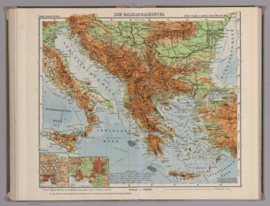
Full Title
Die Balkanhalbinsel. Gotha : Justus Perthes. Sydow-Wagners method. Schul-Atlas. XXI.
List No
13557.101
Note
Map of Balkan region. With 4 insets. Vereinfachte Kegelprojektion.
Author
[Sydow, Emil von., 1812-1873, Wagner, Hermann, 1840-1929]
Full Title
Italien. Gotha : Justus Perthes. Sydow-Wagners method. Schul-Atlas. XXI.
List No
13557.103
Note
Mpa of Italy. With insets: Venedig. Rom. Napel. Vereinfachte Kegelprojektion.
Author
[Sydow, Emil von., 1812-1873, Wagner, Hermann, 1840-1929]
Full Title
Iberische Halbinsel. Gotha : Justus Perthes. Sydow-Wagners method. Schul-Atlas. XXI.
List No
13557.105
Note
Map of Iberian Peninsula, With 4 insets. Vereinf. Kegelproj.
Author
[Sydow, Emil von., 1812-1873, Wagner, Hermann, 1840-1929]
Full Title
Frankreich. Gotha : Justus Perthes. Sydow-Wagners method. Schul-Atlas. XXI.
List No
13557.109
Note
Map of France. With inset: Paris. Vereinfachte Kegelprojektion. Includes list of departments.
Author
[Sydow, Emil von., 1812-1873, Wagner, Hermann, 1840-1929]
Full Title
Britische Inseln, Danemark. Gotha : Justus Perthes. Sydow-Wagners method. Schul-Atlas. XXI.
List No
13557.111
Note
2 maps on 1 sheet. Covers Great Britain, Ireland and Denmark. With 2 insets: London. Mittel-England. Vereinfachte Kegelprojektion.
Author
[Sydow, Emil von., 1812-1873, Wagner, Hermann, 1840-1929]
Full Title
Nordeuropa. Gotha : Justus Perthes. Sydow-Wagners method. Schul-Atlas : 21 Auflage. 1940.
List No
13557.113
Note
Map of Northern Europe, with 3 insets. Vereinfachte Kegelprojektion.
Author
[Sydow, Emil von., 1812-1873, Wagner, Hermann, 1840-1929]
Full Title
Ost-Europa. Gotha : Justus Perthes. Sydow-Wagners method. Schul-Atlas. XXI.
List No
13557.115
Note
Map of Eastern and part of Northern Europe. with 3 insets: Donez-Gebiet. Moskau. Leningrad. Bonne'sche Projektion.
Author
[Sydow, Emil von., 1812-1873, Wagner, Hermann, 1840-1929]
Full Title
Asien: Ubersicht des Reliefs, der politischen Verhaltnisse und Hauptverkehrswege. Gotha : Justus Perthes. Sydow-Wagners method. Schul-Atlas. XXI.
List No
13557.117
Note
Map of Asia. Showing relief, the political boundaries and main traffic routes. Bonne'sche Projektion.
Author
[Sydow, Emil von., 1812-1873, Wagner, Hermann, 1840-1929]
Full Title
Innerasien, Indien, China. Gotha : Justus Perthes. Sydow-Wagners method. Schul-Atlas. XXI.
List No
13557.123
Note
Map of Inner Asiaian countries. With insets: Peiping. Kalkutta. Bonne'sche Projektion.
Author
[Sydow, Emil von., 1812-1873, Wagner, Hermann, 1840-1929]
Full Title
Japan und Indonesien. Gotha : Justus Perthes. Sydow-Wagners method. Schul-Atlas. XXI.
List No
13557.125
Note
2 maps on 1 sheet. with insets: Java; Singapur; Tokyo. Lambert Azimuthal equal-area projection.
Author
[Sydow, Emil von., 1812-1873, Wagner, Hermann, 1840-1929]
Full Title
Afrika : Ubersicht des Relief und der politischen Verhaltnisse. Gotha : Justus Perthes. Sydow-Wagners method. Schul-Atlas : 21 Auflage. 1940.
List No
13557.127
Note
Map of Africa, with 7 inset maps. Sanson Projection.
Author
[Sydow, Emil von., 1812-1873, Wagner, Hermann, 1840-1929]
Full Title
West-, Mittel-, Sud- Afrika. Gotha : Justus Perthes. Sydow-Wagners method. Schul-Atlas. XXI.
List No
13557.129
Note
Map of the Western, Central and Southern Africa. With inset: Westafrika. Lambert Azimuthal equal-area projection.
Author
[Sydow, Emil von., 1812-1873, Wagner, Hermann, 1840-1929]
Full Title
Afrika und Australien : Sonderkarten zur Landerkunde. Gotha : Justus Perthes. Sydow-Wagners method. Schul-Atlas. XXI.
List No
13557.131
Note
12 maps on 1 sheet. Showing climate, industry, geological and soil condition in Africa and Australia.
Author
[Sydow, Emil von., 1812-1873, Wagner, Hermann, 1840-1929]
Full Title
Nordamerika : Ubersicht des Relief und der Politischen Gliederung. Gotha : Justus Perthes. Sydow-Wagners method. Schul-Atlas. XXI.
List No
13557.135
Note
Map of North America. With insets: Zentralamerika. Panama Kanal. San Francisco. Bonne'sche Projektion.
Author
[Sydow, Emil von., 1812-1873, Wagner, Hermann, 1840-1929]
Full Title
Vereinigte Staaten : Mittelamerika, Westindien. Gotha : Justus Perthes. Sydow-Wagners method. Schul-Atlas. XXI.
List No
13557.139
Note
Map of the United States, Central America and West Indies. With insets: Chicago. Los Angeles. Bonne'sche Projektion.
Author
[Sydow, Emil von., 1812-1873, Wagner, Hermann, 1840-1929]
Full Title
Ostliche Vereinigte Staaten. Gotha : Justus Perthes. Sydow-Wagners method. Schul-Atlas. XXI.
List No
13557.141
Note
Map of the Eastern States. With inset: Neu-York u. ungenbung. Albers equal-area conic projection.
Author
[Sydow, Emil von., 1812-1873, Wagner, Hermann, 1840-1929]
Full Title
Sudamerika : Physisch und politisch. Gotha : Justus Perthes. Sydow-Wagners method. Schul-Atlas. XXI.
List No
13557.143
Note
Map of South America. With insets: Continuation of map. Rio de Janeiro. Buenos Aires. Lima. Bonne'sche Projektion.
Author
[Sydow, Emil von., 1812-1873, Wagner, Hermann, 1840-1929]
Full Title
Nordpolarkarte. Gotha : Justus Perthes. Sydow-Wagners method. Schul-Atlas. XXI.
List No
13557.147
Note
Arctic region map, with the North Pole at map center. Includes 4 insets. Aquidistante Azmutal projektion
Author
[Sydow, Emil von., 1812-1873, Wagner, Hermann, 1840-1929]
Full Title
Mitteleuropa Relief. Gotha : Justus Perthes. Sydow-Wagners method. Schul-Atlas. XXII.
List No
13558.051
Note
Relief map of Central Europe. Vereinfachte Kegelprojektion. Includes inset map of Hamburg. Relief shown by gradient tints, hachures and spot height. Depth shown by bathymetric tints, isolines and sounding.
Author
[Sydow, Emil von., 1812-1873, Wagner, Hermann, 1840-1929]
Full Title
Nordost-Deutschland. Gotha : Justus Perthes. Sydow-Wagners method. Schul-Atlas . XXII.
List No
13558.069
Note
Map of Northeastern Germany. Vereinfachte Kegelprojektion.
Author
[Sydow, Emil von., 1812-1873, Wagner, Hermann, 1840-1929]
Full Title
Rheinlande. Gotha : Justus Perthes. Sydow-Wagners method. Schul-Atlas. XXII.
List No
13558.072
Note
Map of Rhein region. With inset map: Rheinisch-Westfalisches Industriegeibiet. Vereinfachte Kegelprojektion.
Author
[Sydow, Emil von., 1812-1873, Wagner, Hermann, 1840-1929]
Full Title
Schlesien und Protektorat-Ostteil. Gotha : Justus Perthes. Sydow-Wagners method. Schul-Atlas. XXII.
List No
13558.078
Note
Map of Silesia and Protectorate Eastern Part. With inset: Oberschlesisches industriegebiet. Vereinfachte Kegelprojektion.
Author
[Sydow, Emil von., 1812-1873, Wagner, Hermann, 1840-1929]
Full Title
Süddeutschland, Schweiz, Protektorat. Gotha : Justus Perthes. Sydow-Wagners method. Schul-Atlas. XXII.
List No
13558.081
Note
Map of Southern Germany and neighboring counties. Vereinfachte Kegelprojektion.
Author
[Sydow, Emil von., 1812-1873, Wagner, Hermann, 1840-1929]
Full Title
Südwest- Deutschland. Gotha : Justus Perthes. Sydow-Wagners method. Schul-Atlas. XXII.
List No
13558.084
Note
Map of Southwestern Germany. Vereinfachte Kegelprojektion.
Author
[Sydow, Emil von., 1812-1873, Wagner, Hermann, 1840-1929]
Full Title
Alpenlander. Gotha : Justus Perthes. Sydow-Wagners method. Schul-Atlas. XXII.
List No
13558.086
Note
Map of the Alpine Countries. With inset map: Wien. Vereinfachte Kegelprojektion.
Author
[Sydow, Emil von., 1812-1873, Wagner, Hermann, 1840-1929]
Full Title
Schweizer Alpen. Gotha : Justus Perthes. Sydow-Wagners method. Schul-Atlas. XXII.
List No
13558.088
Note
Map of Swiss Alps. Vereinfachte Kegelprojektion.
Author
[Sydow, Emil von., 1812-1873, Wagner, Hermann, 1840-1929]
Full Title
Ungar. Tiefebene und Karpaten. Gotha : Justus Perthes. Sydow-Wagners method. Schul-Atlas. XXII.
List No
13558.091
Note
Map of the Hungarian Plain and Carpatian Mountains. With inset map: Budapest. Vereinfachte Kegelprojektion.
Author
[Sydow, Emil von., 1812-1873, Wagner, Hermann, 1840-1929]
Full Title
Ostl. Mitteleuropa. Gotha : Justus Perthes. Sydow-Wagners method. Schul-Atlas. XXII.
List No
13558.093
Note
Map of Eastern Central Europe. Vereinfachte Kegelprojektion.
Author
[Sydow, Emil von., 1812-1873, Wagner, Hermann, 1840-1929]
Full Title
Die Balkanhalbinsel. Gotha : Justus Perthes. Sydow-Wagners method. Schul-Atlas. XXII.
List No
13558.098
Note
Map of Balkan region. With 2 insetsL Athen. Konstantinopel. Vereinfachte Kegelprojektion.
Author
[Sydow, Emil von., 1812-1873, Wagner, Hermann, 1840-1929]
Full Title
Italien. Gotha : Justus Perthes. Sydow-Wagners method. Schul-Atlas. XXII.
List No
13558.100
Note
Map of Italy. With insets: Venedig. Rom. Napel. Vereinfachte Kegelprojektion.
Author
[Sydow, Emil von., 1812-1873, Wagner, Hermann, 1840-1929]
Full Title
Iberische Halbinsel. Gotha : Justus Perthes. Sydow-Wagners method. Schul-Atlas. XXII.
List No
13558.102
Note
Map of Iberian Peninsula, With Inset map: Strasse von Gibraltar. Vereinf. Kegelproj.
Author
[Sydow, Emil von., 1812-1873, Wagner, Hermann, 1840-1929]
Full Title
Frankreich. Gotha : Justus Perthes. Sydow-Wagners method. Schul-Atlas. XXII.
List No
13558.107
Note
Map of France. With inset: Paris. Vereinfachte Kegelprojektion. Includes list of departments.
Author
[Sydow, Emil von., 1812-1873, Wagner, Hermann, 1840-1929]
Full Title
Britische Inseln, Danemark. Gotha : Justus Perthes. Sydow-Wagners method. Schul-Atlas. XXII.
List No
13558.109
Note
2 maps on 1 sheet. Covers Great Britain, Ireland and Denmark. With 2 insets: London. Mittel-England. Vereinfachte Kegelprojektion.
Author
[Sydow, Emil von., 1812-1873, Wagner, Hermann, 1840-1929]
Full Title
Nordeuropa. Gotha : Justus Perthes. Sydow-Wagners method. Schul-Atlas. XXII.
List No
13558.111
Note
Map of Northern Europe, with 3 insets. Vereinfachte Kegelprojektion.
|