|
Author
[Baranov, Anatolij Nikolaevič, Soviet Union. Glavnoe upravlenie geodezii i kartografii]
Full Title
Пенджаб, Калькутта, Бомбей = Pendzhab, Kal'kutta , Bombey. Atlas Mira : 1954. .
List No
13682.184
Note
3 city maps on 1 sheet. Including Punjab, Calcutta and Bombay. Relief shown by gradient tints, contours and spot heights. Depth shown by bathymetric tints, isolines and soundings.
Author
[Baranov, Anatolij Nikolaevič, Soviet Union. Glavnoe upravlenie geodezii i kartografii]
Full Title
Северная Индия = Severnaia Indii. 173-174. Atlas Mira : 1954.
List No
13682.187
Note
Physical map of North India. Relief shown by gradient tints, contours and spot heights. Depth shown by bathymetric tints, isolines and soundings.
Author
[Baranov, Anatolij Nikolaevič, Soviet Union. Glavnoe upravlenie geodezii i kartografii]
Full Title
Долина Верхнего ганга = Dolina Verkhnego Ganga. 175. Atlas Mira : 1954.
List No
13682.188
Note
Map of Upper Ganges Valley, with inset map of Delhi. Relief shown by gradient tints, contours and spot heights.
Author
[Baranov, Anatolij Nikolaevič, Soviet Union. Glavnoe upravlenie geodezii i kartografii]
Full Title
Южная Индия и Цейлон; Бирма = Iuzhnaia Indiia i Tseylon; Birma. 176-177. Atlas Mira : 1954.
List No
13682.190
Note
2 maps on 1 sheet, including: South India, Sri Lanka and Burma. Relief shown by gradient tints, contours and spot heights. Depth shown by bathymetric tints, isolines and soundings.
Author
[Baranov, Anatolij Nikolaevič, Soviet Union. Glavnoe upravlenie geodezii i kartografii]
Full Title
Долина Нижнего Ганга = Dolina Nizhnego Ganga. 178. Atlas Mira : 1954.
List No
13682.191
Note
Map of the Lower Ganges Valley. Relief shown by gradient tints, contours and spot heights.
Author
[Baranov, Anatolij Nikolaevič, Soviet Union. Glavnoe upravlenie geodezii i kartografii]
Full Title
Иран, Афганистан, Западный Пакистан = Iran, Afganistan, Zapadnyy Pakistan. 179-180. Atlas Mira :1954.
List No
13682.193
Note
Physical map of Iran, Afghanistan, West Pakistan. Relief shown by gradient tints, contours and spot heights. Depth shown by bathymetric tints, isolines and soundings.
Author
[Baranov, Anatolij Nikolaevič, Soviet Union. Glavnoe upravlenie geodezii i kartografii]
Full Title
Восточный Район Афганистана. Тегеран, Карачи = Vostochnyy Rayon Afganistana. Tegeran, Karachi. 181. Atlas Mira :1954.
List No
13682.194
Note
Physical map of Eastern Region of Afghanistan. Tehran and Karachi. Relief shown by gradient tints, contours and spot heights
Author
[3, Soviet Union. Glavnoe upravlenie geodezii i kartografii]
Full Title
Западный Иран и Bосточный = Zapadnyy Iran i Vostochnyy. 182-183. Atlas Mira : 1954.
List No
13682.196
Note
Physical map of Western and Eastern Iran. Relief shown by gradient tints, contours and spot heights. Depth shown by bathymetric tints, isolines and soundings.
Author
[3, Soviet Union. Glavnoe upravlenie geodezii i kartografii]
Full Title
Страны Леванта = Strany Levanta. 184. Atlas Mira : 1954.
List No
13682.197
Note
Map of Middle East and eastern Mediterranean Sea region Including Palestine, Syria, Lebanon, Israel, Jordan. Relief shown by shadings, contours and spot height. Depth shown by bathymetric tints, isolines and soundings.
Author
[3, Soviet Union. Glavnoe upravlenie geodezii i kartografii]
Full Title
Турция = Turtsiia. 185-186. Atlas Mira : 1954.
List No
13682.199
Note
Folded map of Turkey. Relief shown by shadings, contours and spot height. Depth shown by bathymetric tints, isolines and soundings.
Author
[3, Soviet Union. Glavnoe upravlenie geodezii i kartografii]
Full Title
Дарданеллы, Босфор = Dardanelly, Bosfor. 187. Atlas Mira : 1954.
List No
13682.200
Note
2 maps on 1 sheet, including Dardanelles and the Bosphorus Straits. Showing Istanbul city and vicinity. Relief shown by shadings, contours and spot height. Depth shown by bathymetric tints, isolines and soundings.
Author
[3, Soviet Union. Glavnoe upravlenie geodezii i kartografii]
Full Title
Юго-Западная Азия = IUgo-Zapadnaia Aziia. 188-189. Atlas Mira : 1954.
List No
13682.202
Note
Map of Southwest Asia. Relief shown by gradient tints, contours and spot heights. Depths shown by gradient tints, isolines and soundings.
Author
[3, Soviet Union. Glavnoe upravlenie geodezii i kartografii]
Full Title
Суэцкий Канал; Бейрут, Дамаск, Багдад = Suetskiy Kanal; Beyrut, Damask, Bagdad. 190. Atlas Mira : 1954.
List No
13682.203
Note
4 maps on 1 sheet. Including: Suez Canal and Beirut, Damascus and Baghdad cities. Relief shown by shadings and spot heights. Depths shown by gradient tints, isolines and soundings.
Author
[3, Soviet Union. Glavnoe upravlenie geodezii i kartografii]
Full Title
Северо-Восточная Африка = Severo-Vostochnaia Afrika. 197-198. Atlas Mira : 1954.
List No
13682.211
Note
Physical map of North-East Africa. Relief shown by gradient tints and spot heights. Depths shown by gradient tints, isolines and soundings.
Author
[3, Soviet Union. Glavnoe upravlenie geodezii i kartografii]
Full Title
Египет. Каир = Yegipet. Kair. 199. Atlas Mira : 1954.
List No
13682.212
Note
Map of Egypt, with inset map of Cairo. Relief shown by gradient tints and spot heights. Depths shown by gradient tints, isolines and soundings.
Author
[3, Soviet Union. Glavnoe upravlenie geodezii i kartografii]
Full Title
Западная Африка = Zapadnaia Afrika. 200-201. Atlas Mira : 1954.
List No
13682.214
Note
Physical map of West Africa. Showing political boundaries. Relief shown by gradient tints and spot heights. Depths shown by gradient tints, isolines and soundings.
Author
[3, Soviet Union. Glavnoe upravlenie geodezii i kartografii]
Full Title
Северо - Западная Африка. Алжир = Severo - Zapadnaia Afrika. Alzhir. 202. Atlas Mira : 1954.
List No
13682.215
Note
Map of Northwest Africa, with inset map of the city of Alzhir (Algiers). Relief shown by shadings and spot heights. Depths shown by gradient tints, isolines and soundings.
Author
[3, Soviet Union. Glavnoe upravlenie geodezii i kartografii]
Full Title
Экваториальная Африка = Ekvatorial'naia Afrika. 203-204. Atlas Mira : 1954.
List No
13682.217
Note
Folded map of Equatorial Africa. Relief shown by gradient tints and spot heights. Depths shown by gradient tints, isolines and soundings.
Author
[3, Soviet Union. Glavnoe upravlenie geodezii i kartografii]
Full Title
Катангa. Острова Сан-Томе и Принсипе; Маскаренские Острова = Katanga. Ostrova San-Tome i Prinsipe; Maskarenskie Ostrova. 205. Atlas Mira : 1954.
List No
13682.218
Note
Map of Katanga, with 2 insets: Islands of Sao Tome and Principe, and Mascarene Islands. Relief shown by gradient tints and spot heights. Depths shown by gradient tints, isolines and soundings.
Author
[3, Soviet Union. Glavnoe upravlenie geodezii i kartografii]
Full Title
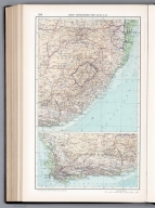
Южная Африка = IUzhnaia Afrika. 206-207. Atlas Mira : 1954.
List No
13682.220
Note
Political and physical map of South Africa and islands of Mascarene. Relief shown by gradient tints and spot heights. Depths shown by gradient tints, isolines and soundings.
Author
[3, Soviet Union. Glavnoe upravlenie geodezii i kartografii]
Full Title
Южно-Африканский Союз (Восток). Южно-Африканский Союз (Юг) = IUzhno-Afrikanskiy Soiuz (Vostok). IUzhno-Afrikanskiy Soiuz (Iug). 208. Atlas Mira : 1954.
List No
13682.221
Note
2 maps on 1 sheet. Relief shown by gradient tints and spot heights. Depths shown by gradient tints, isolines and soundings.
Author
[3, Soviet Union. Glavnoe upravlenie geodezii i kartografii]
Full Title
Северная Америка = Severnaia Amerika. 209-210. Atlas Mira : 1954.
List No
13682.223
Note
Physical map of North America. Showing Ocean surface currents. Relief shown by gradient tints and spot heights. Depths shown by gradient tints, isolines and soundings.
Author
[3, Soviet Union. Glavnoe upravlenie geodezii i kartografii]
Full Title
Дельта Миссисипи. Бермудские Острова. Панамский Канал = Del'ta Missisipi. Bermudskie Ostrova. Panamskiy Kanal. 214. Atlas Mira : 1954.
List No
13682.227
Note
Map of Panama Canal, with insets: Mississippi Delta and Bermuda Island. Relief shown by gradient tints and spot heights. Depths shown by gradient tints, isolines and soundings.
Author
[3, Soviet Union. Glavnoe upravlenie geodezii i kartografii]
Full Title
Аляска = Aliaska. 215-216. Atlas Mira : 1954.
List No
13682.229
Note
Physical map of Alaska. Relief shown by gradient tints and spot heights. Depths shown by gradient tints, isolines and soundings.
Author
[3, Soviet Union. Glavnoe upravlenie geodezii i kartografii]
Full Title
Алеутские Острова = Aleutskie Ostrova. 217. Atlas Mira : 1954.
List No
13682.230
Note
Map of Aleutian Islands. Relief shown by gradient tints and spot heights. Depths shown by gradient tints, isolines and soundings.
Author
[3, Soviet Union. Glavnoe upravlenie geodezii i kartografii]
Full Title
Северная Канада и Гренландия = Severnaia Kanada i Grenlandiia. 218-219. Atlas Mira : 1954.
List No
13682.232
Note
Physical map of Northern Canada and Greenland. Relief shown by gradient tints and spot heights. Depths shown by gradient tints, isolines and soundings.
Author
[3, Soviet Union. Glavnoe upravlenie geodezii i kartografii]
Full Title
Западная Канада = Zapadnaia Kanada. 221-222. Atlas Mira : 1954.
List No
13682.235
Note
Physical map of Western Canada. Relief shown by gradient tints and spot heights. Depths shown by gradient tints, isolines and soundings.
Author
[3, Soviet Union. Glavnoe upravlenie geodezii i kartografii]
Full Title
Восточная Канада = Vostochnaia Kanada. 224-225. Atlas Mira : 1954.
List No
13682.238
Note
Physical map of Eastern Canada and Northeast of the United States. Relief shown by shadings and spot heights. Depths shown by gradient tints, isolines and soundings.
Author
[3, Soviet Union. Glavnoe upravlenie geodezii i kartografii]
Full Title
Юг Онтарио = IUg Ontario. 226. Atlas Mira : 1954.
List No
13682.239
Note
Map of Ontario South. Relief shown by shadings and spot heights. Depths shown by isolines and soundings.
Author
[3, Soviet Union. Glavnoe upravlenie geodezii i kartografii]
Full Title
Нью - Йорк. Вашингтон = N'yu - York. Vashington. 229. Atlas Mira : 1954.
List No
13682.242
Note
Map of New York, with inset map of Washington. Relief shown by hachures and spot heights. Depth shown by gradient tints, isoline and soundings.
Author
[3, Soviet Union. Glavnoe upravlenie geodezii i kartografii]
Full Title
Северо - Восток США = Severo - Vostok SShA. 230-231. Atlas Mira : 1954.
List No
13682.244
Note
Physical map of the Northeast United States. Relief shown by shadings and spot heights. Depths shown by gradient tints, isolines and soundings.
Author
[3, Soviet Union. Glavnoe upravlenie geodezii i kartografii]
Full Title
Новая Англия = Novaia Angliia. 232. Atlas Mira : 1954.
List No
13682.245
Note
Physical map of New England. Relief shown by shadings and spot heights. Depths shown by gradient tints, isolines and soundings.
Author
[3, Soviet Union. Glavnoe upravlenie geodezii i kartografii]
Full Title
Северо-Восточный Центр США = Severo-Vostochnyy Tsentr SShA. 233-234. Atlas Mira : 1954.
List No
13682.247
Note
Map of the Northeast Central of the United States and Western Pennsylvania and Ohio. Relief shown by shadings and spot heights. Depths shown by gradient tints, isolines and soundings.
Author
[3, Soviet Union. Glavnoe upravlenie geodezii i kartografii]
Full Title
Западная Пенсильвания и Огайо = Zapadnaia Pensil'vaniia i Ogayo. 235. Atlas Mira : 1954.
List No
13682.248
Note
Map of the Western Pennsylvania and Ohio. Relief shown by shadings, contours and spot heights. Relief shown by shadings and spot heights. Depths shown by gradient tints, isolines and soundings.
Author
[3, Soviet Union. Glavnoe upravlenie geodezii i kartografii]
Full Title
Юго-Восток США = IUgo-Vostok Ssha. 236-237. Atlas Mira : 1954.
List No
13682.250
Note
Physical map of the Southeast of the United States. Showing state boundaries. Relief shown by shadings and spot heights. Depths shown by gradient tints, isolines and soundings.
Author
[3, Soviet Union. Glavnoe upravlenie geodezii i kartografii]
Full Title
Срединно - Атлантический район США = Sredinno - Atlanticheskiy rayon SShA. 238. Atlas Mira : 1954.
List No
13682.251
Note
Map of Mid-Atlantic Region of the United States. Relief shown by shadings and spot heights. Depths shown by gradient tints, isolines and soundings.
Author
[3, Soviet Union. Glavnoe upravlenie geodezii i kartografii]
Full Title
Центральная Часть Юга США = Tsentral'naia Chast' IUga SShA. 239-240. Atlas Mira : 1954.
List No
13682.253
Note
Map of South Central of the United States. Showing state boundaries. Relief shown by shadings, contours and spot heights. Depths shown by gradient tints, isolines and soundings.
Author
[3, Soviet Union. Glavnoe upravlenie geodezii i kartografii]
Full Title
Иллинойс = Illinoys. 241. Atlas Mira : 1954.
List No
13682.254
Note
Map of Illinois. Relief shown by shadings, contours and spot heights. Depths shown by gradient tints, isolines and soundings.
Author
[3, Soviet Union. Glavnoe upravlenie geodezii i kartografii]
Full Title
Калифорния = Kaliforniia. 244. Atlas Mira : 1954.
List No
13682.257
Note
Map of California. Relief shown by shadings, contours and spot heights. Depths shown by gradient tints, isolines and soundings.
Author
[3, Soviet Union. Glavnoe upravlenie geodezii i kartografii]
Full Title
Мексика = Meksika. 245-246. Atlas Mira : 1954.
List No
13682.259
Note
Physical map of Mexico, with inset of continuation map, Yucatan Peninsula. Relief shown by gradient tints, contours and spot heights. Depths shown by bathymetric tints, isolines and soundings.
Author
[3, Soviet Union. Glavnoe upravlenie geodezii i kartografii]
Full Title
Центральная Мексика = Tsentral'naia Meksika. 247. Atlas Mira : 1954.
List No
13682.260
Note
Map of Central Mexico. Relief shown by shadings, contours and spot heights. Depths shown by bathymetric tints, isolines and soundings.
Author
[3, Soviet Union. Glavnoe upravlenie geodezii i kartografii]
Full Title
Центральная Америка и Вест-Индия = Tsentral'naia Amerika i Vest-Indiia. 248-249. Atlas Mira : 1954.
List No
13682.262
Note
Physical map of Central America and West Indies. Relief shown by shadings, contours and spot heights. Depths shown by bathymetric tints, isolines and soundings.
Author
[3, Soviet Union. Glavnoe upravlenie geodezii i kartografii]
Full Title
Большие Антильские О-Ва = Bol'shiye Antil'skiye O-Va. 250. Atlas Mira : 1954
List No
13682.263
Note
Map of Greater Antilles Islands, with inset map of Puerto Rico. Relief shown by shadings and spot heights. Depths shown by bathymetric tints, isolines and soundings.
Author
[3, Soviet Union. Glavnoe upravlenie geodezii i kartografii]
Full Title
Малые Антильские Острова = Malye Antil'skie Ostrova. Inset: Buenos-Ayres. 256. Atlas Mira : 1954.
List No
13682.269
Note
Map of Lesser Antilles Islands, with inset map of Buenos Aires.
Author
[3, Soviet Union. Glavnoe upravlenie geodezii i kartografii]
Full Title
Южная Америка (Северо-Запад) = IUzhnaia Amerika (Severo-Zapad). 257-258 Atlas Mira : 1954.
List No
13682.271
Note
Map of South America (Northwest). Relief shown by gradient tints and spot heights. Depths shown by bathymetric tints, isolines and soundings.
Author
[3, Soviet Union. Glavnoe upravlenie geodezii i kartografii]
Full Title
Венесуэла (Северная Часть) = Venesuela (Severnaia Chast'). 259. Atlas Mira : 1954.
List No
13682.272
Note
Map of Venezuela (Northern Part). Relief shown by gradient tints and spot heights. Depths shown by bathymetric tints, isolines and soundings.
Author
[3, Soviet Union. Glavnoe upravlenie geodezii i kartografii]
Full Title
Южная Америка (Восток) = IUzhnaia Amerika (Vostok). 260-261. Atlas Mira : 1954.
List No
13682.274
Note
Map of South America East. Showing political boundaries. Relief shown by gradient tints and spot heights. Depths shown by bathymetric tints, isolines and soundings.
Author
[3, Soviet Union. Glavnoe upravlenie geodezii i kartografii]
Full Title
Юго-Восток Бразилии = IUgo-Vostok Brazilii. Insets: Rayon San-Paulu. Rio-de-Zhaneyro. 262. Atlas Mira : 1954.
List No
13682.275
Note
Map of Southeast Brazil, with inset maps: Sao Paulo region and Rio de Janeiro. Showing political boundaries. Relief shown by gradient tints and spot heights. Depths shown by bathymetric tints, isolines and soundings.
Author
[3, Soviet Union. Glavnoe upravlenie geodezii i kartografii]
Full Title
Южная Америка (Юг) = IUzhnaia Amerika (Iug). 263-264. Atlas Mira : 1954.
List No
13682.277
Note
Map of Southern South America. Relief shown by gradient tints and spot heights. Depths shown by bathymetric tints, isolines and soundings.
Author
[3, Soviet Union. Glavnoe upravlenie geodezii i kartografii]
Full Title
Среднее Чили. Центральная Аргентина (Пампа) = Sredneye Chili. Tsentral'naia Argentina (Pampa). 265. Atlas Mira : Moskva 1954.
List No
13682.278
Note
Map of Central Argentina (Pampa), with inset: Central Chile. Relief shown by gradient tints and spot heights. Depths shown by bathymetric tints, isolines and soundings.
|