|
Author
Philip, George, 1870-1937.
Full Title
Arabia, the Red Sea and the Valley of the Nile. Including Egypt, Nubia, and Abyssinia.
List No
15487.077
Author
Philip, George, 1870-1937.
Full Title
Chinese Empire and Japan.
List No
15487.092
Author
Philip, George, 1870-1937.
Full Title
The Japanese Empire and Korea.
List No
15487.093
Author
Philip, George, 1870-1937.
Full Title
Africa.
List No
15487.096
Author
Philip, George, 1870-1937.
Full Title
Central Africa.
List No
15487.099
Author
Philip, George, 1870-1937.
Full Title
North America.
List No
15487.106
Author
Philip, George, 1870-1937.
Full Title
(Composite map to) Canada (East and West Sheets)
List No
15487.115
Author
Philip, George, 1870-1937.
Full Title
Manitoba. With Parts of Saskatchewan & Ontario.
List No
15487.116
Author
Philip, George, 1870-1937.
Full Title
The Pacific States and a Portion of the North-Western States (United States II Western Division)
List No
15487.130
Author
Philip, George, 1870-1937.
Full Title
(Composite map to) South America (Northern and Southern Sheets).
List No
15487.141
Author
Philip, George, 1870-1937.
Full Title
Australia.
List No
15487.145
Author
Philip, George, 1870-1937.
Full Title
Southeast Australia Showing the Colonies of New South Wales, Victoria, Queensland & South Australia.
List No
15487.148
Author
Elwe, Jan Barend
Full Title
(Covers to) Atlas der wereld.
List No
14478.001
Note
Covers to Atlas der wereld. Bound in contemporary half-calf over marbled paper boards. With gilt ornamentation and title on spine. Title translates to: Atlas of the world.
Author
Elwe, Jan Barend
Full Title
(Title Page to) Atlas. Amstelædami, Chés J. B. Elwe.
List No
14478.002
Note
Title page to Atlas der wereld. Features a scene of Poseidon and other figures observing a terrestrial globe, with Atlas holding a celestial globe in the background, and cherubs in flight above, together holding a banner with the title. Hand-colored engraving. Imprint at bottom.
Author
Elwe, Jan Barend
Full Title
Planisphere representant toute l'etendue du monde dans l'ordre qu'on a suivi dans ce livre.
List No
14478.015
Note
World map, in circular format with the North Pole at the center. Title translates to: Planisphere representing the entire expanse of the world in the order we have followed in this book. Shows continents, countries, bodies of water, drainage, coastlines and islands. Includes latitudinal and longitudinal lines. Map sits of the shoulders of Atlas, who appears within his own scenery. Hand-colored engraving. Map is 43 x 27 cm, on sheet 58 x 34 cm.
Author
Elwe, Jan Barend
Full Title
Sterre kaert of hemels pleyn, waer door men kan wete hoe laet dat het is over de gehele aertkloot, op alle meridiane en polus hoogte, en, op wat lengte en brete, de voorsz sterre staen, bezuyde en benoorde de liniæ æquinoctiae. Te Amsterdam by J. B. Elwe.
List No
14478.016
Note
Celestial map, featuring illustrations of constellations. With a calendar above and zodiac tables below. Includes compass roses with north oriented toward top of sheet, latitudinal and longitudinal lines, and descriptive text. Extended statement of responsibility, mostly faded, in bottom margin. Hand-colored engraving. Map is 47 x 58 cm, on double sheet 58 x 70 cm.
Author
Elwe, Jan Barend
Full Title
Mappe mondi ou description du globe terrestre & aquatique suivant les Dernieres & Meilleures. A Amsterdam. Chés J. B. Elwe. MDCCXCII.
List No
14478.017
Note
World map, in circular format, featuring both the Western and Eastern Hemispheres. Shows continents, countries, cities, topography, bodies of water, drainage, coastlines and islands. Relief shown pictorially. Includes latitudinal and longitudinal lines. With vignettes of figures, fauna and flora in the margins. Hand-colored engraving. Map is 47 x 62 cm, on double sheet 58 x 70 cm.
Author
[Elwe, Jan Barend, L'Isle, Guillaume de, 1675-1726]
Full Title
Europe, composée par G. de L'Isle, et corrigée selon le plus nouvelle observations. A Amsterdam. Chés Jan. Bt. Elwe. MDCCXCII.
List No
14478.018
Note
Map of Europe and vicinity. Shows countries, cities, topography, bodies of water, drainage, coastlines and islands. Relief shown pictorially. Includes a compass rose with north oriented toward top of sheet, latitudinal and longitudinal lines, and descriptive notes throughout. Hand-colored engraving. Map is 47 x 58 cm, on double sheet 58 x 70 cm.
Author
Elwe, Jan Barend
Full Title
Historische en geographische tafel. Om te leren een kort begrip vande Landen en Staaten in Europa. Haar grootheyt Besitting en alles dat tot onderricht der Lief hebbers vande Land beschryvinge dienen kan te Amsterdam. By J. B. Elwe. 1792.
List No
14478.019
Note
Timeline of Europe. Includes information on the different countries therein. With coats of arms. Hand-colored engraving. Timeline is 48 x 57 cm, on double sheet 58 x 70 cm.
Author
Elwe, Jan Barend
Full Title
Les Royaumes d'Espagne et de Portugal. Ches Jan. Bt. Elwe. A Amsterdam. MDCCXCII.
List No
14478.020
Note
Map of Spain, Portugal and vicinity. Shows countries, regions, cities, churches, railways, topography, bodies of water, drainage, coastlines and islands. Relief shown pictorially. Includes a legend, compass rose with north oriented toward top of sheet, three bar scales, latitudinal and longitudinal lines, and descriptive text. Hand-colored engraving. Map is 49 x 57 cm, on double sheet 58 x 70 cm.
Author
Elwe, Jan Barend
Full Title
Carte nouvelle du Royaume de France divisé en toutes ses provinces et ses acquisitions. Dressée suivent les dermiers observations de Mrs. de l'Academie Royale des Sciences et autres Geometres ou Astronomes etc. A Amsterdam. Chés Jan. Bt. Elwe. MDCCXCII.
List No
14478.021
Note
Map of France and vicinity. Shows countries, regions, cities, churches, railways, topography, vegetation, bodies of water, drainage, coastlines and islands. Relief shown pictorially. Includes a legend, compass rose with north oriented toward top of sheet, seven bar scales, latitudinal and longitudinal lines, and descriptive text. Inset tables, illustrated with coats of arms, entitled: La France divisée en ses douze anciens gouvernemens et en ses vingt quatre nouveaux et l'on le remarque en est ordre. With a decorative cartouche. Hand-colored engraving. Map is 47 x 58 cm, on double sheet 58 x 70 cm.
Author
Elwe, Jan Barend
Full Title
Les Isles Britanniques qui contiennent les Royaumes d'Angleterre, Escosse, et Irlande distingués en leurs principales provinces subdivisées en leurs Shireries ou Comté composé selon les plus nouvelle observations des meilleurs geographes. Publiée par Jan Bt. Elwe. A Amsterdam. MDCCXCII.
List No
14478.022
Note
Map of the British Isles and vicinity. Shows countries, regions, cities, topography, bodies of water, drainage, coastlines and islands. Relief shown pictorially. Includes a compass rose with north oriented toward top of sheet, three bar scales, latitudinal and longitudinal lines. Inset map: La Mer d'Escosse [= The Sea of Scotland]. With a decorative cartouche and vignettes. Hand-colored engraving. Map is 46 x 58 cm, on double sheet 58 x 70 cm.
Author
[Elwe, Jan Barend, L'Isle, Guillaume de, 1675-1726]
Full Title
(Composite Map to) Carte des Courones du Nord. Dediée au tres Puissant et tres Invincible Prince Charles XII Roy de Suede, des Gots et des Vandales Grand Duc de Finlande &c. Par son tres humble et tres obeisant serviteur Guillaume del'Isle de l'Academie Rle. des Sciences a Amsterdam Chéz Jan Bt. Elwe. MDCCXCII.
List No
14478.033
Note
Composite map of Scandinavia and vicinity, featuring Norway Sweden and Finland. Shows countries, regions, cities, topography, vegetation, bodies of water, drainage, coastlines and islands. Relief shown pictorially. Includes compass roses with north oriented toward top of sheet, four bar scales, latitudinal and longitudinal lines. With a decorative cartouche. Hand-colored engraving. Composite map is 91 x 60 cm, on two double sheets, together 116 x 70 cm.
Author
[Elwe, Jan Barend, L'Isle, Guillaume de, 1675-1726]
Full Title
(Composite Map to) Partie meridionale de Moscovie dressée par G. de L'Isle rectisié & augmente. Chez Jan Barend Elwe. A Amsterdam. -- Cartie nouvelle de Moscovie represente la partie septenntrionale dressée par G. de L'Isle rectisié & augmente. A Amsterdam. Chés Jan B. Elwe. MDCCXCII.
List No
14478.038
Note
Composite map of the Moscow Region, Russia. Shows regions, cities, railways, topography, vegetation, bodies of water, drainage, shorelines, coastlines and islands. Relief shown pictorially. Includes a compass rose with north oriented toward top of sheet, three bar scales, latitudinal and longitudinal lines, and descriptive notes throughout.. With decorative cartouches. Hand-colored engraving. Composite map is 80 x 55 cm, on two double sheets, together 116 x 70 cm.
Author
Elwe, Jan Barend
Full Title
L'Asia divisée en ses empires, royaumes, et etats. Corrigée & rectisicé. A Amsterdam. Chés J. B. Elwe. MDCCXCII.
List No
14478.040
Note
Map of Asia. Shows countries, regions, cities, topography, vegetation, deserts, bodies of water, drainage, coastlines and islands. Relief shown pictorially. Includes nine bar scales, latitudinal and longitudinal lines, and descriptive notes throughout. With a decorative cartouche. Hand-colored engraving. Map is 46 x 58 cm, on double sheet 58 x 70 cm.
Author
Elwe, Jan Barend
Full Title
(Composite Map to) 1 Partie de la nouvelle grande carte des Indes Orientales, contenant les Terres du Mogol, Surate, Malabar, Cormandel, Bengale, Aracan, Pegu, Siam, Camboje, Tonquin, & une partie de la Chine -- 2 Partie de la nouvelle grande carte des Indes Orientales, contenant les Empires de la Chine & du Japon, les Isles Philippines, Couchin, & les Isles Marianes -- 3 Partie de la nouvelle grande carte des Indes Orientales, contenant les Isles Maldives, Ceyi, An, Malacca, Sumatra &c. avec les terres adjacentes de Couchin, Negombo, Colombo & Sourabaia -- 4 Partie de la nouvelle grande carte des Indes Orientales, contenant les Isles de Borneo, Java, Celebes, Mindanao, Gilolo, Molucques, La Nouvelle Guinée, La Nouvelle Bretagne, & les Nouvelles Philippines; avec les Isles de Sumbawa, Serbira, Solor, Bouton & Pangesane dressée avec soin, sur pluseurs cartes manuscrites, par un habile connoisseur; & publiée a Amsterdam par Jan Bt. Elwe. MDCCXCII.
List No
14478.048
Note
Composite map of Asia, including the Mughal Empire [current-day India, Pakistan and Afghanistan], the Malabar, Coromandel, Bengal and Aracan regions, Siam [current-day Thailand], Camdodia, Tonquin [current-day Vietnam], China, Japan, the Philippines, the Mariana Islands, Maldives, Ceylon [current-day Sri Lanka], Malaysia, Sumatra (Indonesia), Borneo, Java, Celebes [Sulawesi], Gilolo [Halmahera], the Maluku Islands (Indonesia), Mindanao (Philippines) and Papua New Guinea. Shows countries, regions, cities, topography, vegetation, bodies of water, drainage, coastlines and islands. Relief shown pictorially. Includes compass roses with north oriented toward top of sheet, bar scales, latitudinal and longitudinal lines, and descriptive notes throughout. Inset maps: Carte de Royaume de Couchin de Coilan et de Cranganor -- Carte de Nigombo, Colombo -- Carte de Princepaute de Soerabaye et Terre de Grissik -- Isle de Sumbawa -- Isles de Serbira et de Solor -- Isles de Bouton et Pangesane. Hand-colored engraving. Composite map is 98 x 118 cm, on four double sheets, together 116 x 140 cm.
Author
Elwe, Jan Barend
Full Title
L'Afrique divisée en ses Empire Royaumes et Etats dressées sur les dernieres observations. A Amsterdam. Chés J. B. Elwe. MDCCXCII.
List No
14478.049
Note
Map of Africa and vicinity. Shows countries, regions, cities, topography, vegetation, deserts, bodies of water, drainage, coastlines and islands. Relief shown pictorially. Includes six bar scales, latitudinal and longitudinal lines. With decorative cartouches. Hand-colored engraving. Map is 44 x 57 cm, on double sheet 58 x 70 cm.
Author
Elwe, Jan Barend
Full Title
Amerique Septentrionale divisée en ses principales parties. A Amsterdam. Chés Jan. Bt. Elwe. MDCCXCII.
List No
14478.053
Note
Map of North America and vicinity. Shows countries, regions, cities, topography, vegetation, bodies of water, drainage, coastlines and islands. Relief shown pictorially. Includes six bar scales, latitudinal and longitudinal lines. With decorative cartouches. Map is 45 x 57 cm, on double sheet 58 x 70 cm.
Author
Elwe, Jan Barend
Full Title
L'Amerique Meridionale divisée en ses principales parties. A Amsterdam. Chés Jan. Bt. Elwe. MDCCXCII.
List No
14478.054
Note
Map of South America and vicinity. Shows countries, regions, cities, topography, vegetation, bodies of water, drainage, coastlines and islands. Relief shown pictorially. Includes eight bar scales, latitudinal and longitudinal lines, and descriptive notes throughout. With decorative cartouches. Map is 45 x 59 cm, on double sheet 58 x 70 cm.
Author
Elwe, Jan Barend
Full Title
De Golf van Mexico, de eilanden en het omleggende land. Zaamengesteld, en op nieuw gecorrigeerd volgens de beste Waarnemingen. Te Amsterdam, by Jan Barend Elwe, MDCCXCII.
List No
14478.055
Note
Map of the Gulf of Mexico and vicinity. Shows countries, regions, cities, topography, vegetation, bodies of water, drainage, coastlines and islands. Features routes of exploration. Relief shown pictorially. Includes a compass rose with north oriented toward top of sheet, two bar scales, latitudinal and longitudinal lines, and descriptive notes throughout. With a decorative cartouche. Map is 47 x 56 cm, on double sheet 58 x 70 cm.
Author
Elwe, Jan Barend
Full Title
Poliometria Europae maxime autem Germaniae ac Finitimorum Locorum. Ex offinica Jan Barn. Elwe. Amsteli.
List No
14478.056
Note
Table of travel distances in Europe, especially Germany. Includes descriptive text. Table is 48 x 58 cm, on double sheet 58 x 70 cm.
Author
Mager, Henri
Full Title
(Covers to) Petit Atlas De Geographie En Relief.
List No
15537.001
Note
Date estimated.
Author
Mager, Henri
Full Title
(Title page to) Petit Atlas De Geographie En Relief.
List No
15537.002
Note
Date estimated.
Author
Mager, Henri
Full Title
No. 1 Planisphere.
List No
15537.003
Note
Date estimated.
Author
Mager, Henri
Full Title
No. 2. Europe Physique.
List No
15537.004
Note
Date estimated.
Author
Mager, Henri
Full Title
No. 3. Europe Politique.
List No
15537.005
Note
Date estimated.
Author
Mager, Henri
Full Title
No. 4. Les Alpes.
List No
15537.006
Note
Date estimated.
Author
Mager, Henri
Full Title
No. 5. France Physique.
List No
15537.007
Note
Date estimated.
Author
Mager, Henri
Full Title
No. 6. France Politique.
List No
15537.008
Note
Date estimated.
Author
Mager, Henri
Full Title
No. 7. Bassin De La Seine.
List No
15537.009
Note
Date estimated.
Author
Mager, Henri
Full Title
No. 8. Bassin De La Loire.
List No
15537.010
Note
Date estimated.
Author
Mager, Henri
Full Title
No. 9. Bassin De La Garonne.
List No
15537.011
Note
Date estimated.
Author
Mager, Henri
Full Title
No. 10. Bassin Du Rhône.
List No
15537.012
Note
Date estimated.
Author
Mager, Henri
Full Title
No. 11. Bassin Du Rhin.
List No
15537.013
Note
Date estimated.
Author
Mager, Henri
Full Title
No. 12. Colonied Francaises.
List No
15537.014
Note
Date estimated.
Author
Mager, Henri
Full Title
No. 13. Iles Britanniques.
List No
15537.015
Note
Date estimated.
Author
Reynolds, James, 1817-1876
Full Title
(Covers to) A series of large colored diagrams illustrative of physical geography, compiled from the best authorities; comprising the physical features of the land. The phenomena and movements of the waters. The distribution of the rain. Diagram of climates. The volcanic system of the globe. London : Published by James Reynolds, 174, Strand.
List No
14338.001
Note
Covers to A series of large colored diagrams illustrative of physical geography. Bound within beige paper covers. Includes title, imprint and two seals - one with a scene of Roman figures, the other with text: 1862 Londini ; Honoris Causa. "Prize medal awarded for Reynolds's educational diagrams, Class XXIX. International Exhibition 1862" and "Price nine shillings."
Author
Reynolds, James, 1817-1876
Full Title
(Composite Text to) Descriptive notes to accompany Reynold's geographical diagrams. London : James Reynolds, 174, Strand.
List No
14338.002
Note
Composite text to descriptive notes accompanying A series of large colored diagrams illustrative of physical geography. Booklet bound within atlas, preceding maps. Includes sections: Physical features of the land -- Mountains -- Mountain chains -- Plateaus of table-lands -- Plains -- Deserts -- General structure of the continents -- Relief of the continents -- Movements of the waters -- Waves -- Tides -- Marine currents -- Influence of the marine currents -- Depth of the ocean -- River systems -- Distribution of the winds -- Trade winds -- Periodical winds -- Monsoons -- Etesian winds -- Land and sea breezes -- Variable winds -- Hot winds -- Storm winds -- Hurricanes and tyfoons -- Utility of the winds -- Distribution of rain -- Rainless districts -- Regions of periodical rain -- Zone of constant precipitation -- Regions of variable rain -- Snow -- Distribution of climates -- Isothermal lines -- Region of greatest heat -- Region of greatest cold -- Climate in ascending regions -- Volcanic system of the globe -- Earthquakes -- Earthquake regions -- Volcanoes -- Distribution of volcanoes -- Volcanic eruptions -- Fire springs and fire-hills -- Geysers. Spans pages [1]-16, with imprint on final page. Each page is 22 x 14 cm.
Author
Reynolds, James, 1817-1876
Full Title
Physical features of the land. Published by James Reynolds, 174 Strand, London.
List No
14338.003
Note
World map showing physical geography around the globe. Features mountain chains, peaks, plateaus ("table lands"), plains, valleys, lowlands, vegetation, deserts, drainage, coastlines and islands. Relief shown with hachures. Includes latitudinal and longitudinal lines, as well as a legend and explanatory notes throughout. Colored engraving double plate. Map is 43 x 69 cm, on sheet 51 x 77 cm. Descriptive notes in accompanying booklet preceding maps.
Author
Reynolds, James, 1817-1876
Full Title
Movements of the waters. Published by James Reynolds, 174 Strand, London.
List No
14338.004
Note
World map showing the movement of water around the globe. Features ocean currents, tides, river systems, vegetation, deserts, drainage, coastlines and islands. Relief shown with hachures. Includes latitudinal and longitudinal lines, as well as arrows indicating the direction of water, a legend and explanatory notes throughout. Colored engraving double plate double plate. Map is 43 x 69 cm, on sheet 51 x 77 cm. Descriptive notes in accompanying booklet preceding maps.
Author
Reynolds, James, 1817-1876
Full Title
Distribution of the winds. Published by James Reynolds, 174 Strand, London.
List No
14338.005
Note
World map showing the distribution of winds around the globe. Features different types of winds and weather systems (such as monsoons and hurricanes), vegetation, deserts, drainage, coastlines and islands. Relief shown with hachures. Includes latitudinal and longitudinal lines, as well as arrows indicating the direction of winds, a compass rose and explanatory notes throughout. Colored engraving double plate. Map is 43 x 69 cm, on sheet 51 x 77 cm. Descriptive notes in accompanying booklet preceding maps.
Author
Reynolds, James, 1817-1876
Full Title
Distribution of the rain. Published by James Reynolds, 174 Strand, London.
List No
14338.006
Note
World map showing the distribution of rain around the globe. Features comparative amounts of rain, vegetation, deserts, drainage, coastlines and islands. Relief shown with hachures. Includes latitudinal and longitudinal lines, as well as bands indicating areas where snow falls, and explanatory notes throughout. Colored engraving double plate. Map is 43 x 69 cm, on sheet 51 x 77 cm. Descriptive notes in accompanying booklet preceding maps.
Author
Reynolds, James, 1817-1876
Full Title
Distribution of the climates. Published by James Reynolds, 174 Strand, London.
List No
14338.007
Note
World map showing the distribution of climates around the globe. Features comparative features of different climates (such as ice and heat), vegetation, deserts, drainage, coastlines and islands. Relief shown with hachures. Includes latitudinal and longitudinal lines, as well as isotherms indicating mean annual temperature, and explanatory notes throughout. Colored engraving double plate. Map is 43 x 69 cm, on sheet 51 x 77 cm. Descriptive notes in accompanying booklet preceding maps.
Author
Reynolds, James, 1817-1876
Full Title
Volcanic system of the globe. Published by James Reynolds, 174 Strand, London.
List No
14338.008
Note
World map showing volcanic systems around the globe. Features comparative active volcanoes, extinct volcanoes, earthquake regions, vegetation, deserts, drainage, coastlines and islands. Relief shown with hachures. Includes latitudinal and longitudinal lines, as well as a legend, and explanatory notes throughout. Colored engraving double plate. Map is 43 x 69 cm, on sheet 51 x 77 cm. Descriptive notes in accompanying booklet preceding maps.
Author
Brue, Adrien Hubert, 1786-1832
Full Title
(Title Page to) Atlas physique et politique des cinq parties du monde, par H. Brueì, contenant aussi un choix de cartes de geìographie ancienne et modern, dresseìes par divers auteurs. Paris, Chez J. Goujon, Geographe-Editeur.
List No
13565.002
Note
Titel page includes table of contents.
Author
Brue, Adrien Hubert, 1786-1832
Full Title
Tableau analytique des differentes positions de la Sphere, des differents systemes, des revolutions et des distances des Planetes, &c. Par C.F. Delamarche, Geographer. A Paris ... 1825. Grave par Barriere Freres. (to accompany) Atlas physique et politique des cinq parties du monde, par H. Brue.
List No
13565.003
Note
Illustrated spheres, celestial and a terrestrial globe. Two spheres demonstrating the celestial systems of Ptolemy and Copernicus, including diagrams of the solar system, the phases of the moon, the eclipses of the sun and the moon. Includes Tables with descriptive text.
Author
Brue, Adrien Hubert, 1786-1832
Full Title
Tableau Comparatif et Figure de La Hauteur des Principales Montagnes et du Cours des Principaux Fleuves due Monde. Paris. Chez J. Goujon & J. Andriveau. 1829. Fleuves graves par Dumortier. Les Montagnes par A. Hocquart. La Lettre par Arnoul. (to accompany) Atlas physique et politique des cinq parties du monde, par H. Brue.
List No
13565.004
Note
Unnumbered, supplementary plate. Comparative view and Figure of the Height of the Main Mountains and the Course of the Main Rivers of the World. Beautifully colored with fine graphics and art and closely corresponding statistical tables and extensive annotations.
Author
Brue, Adrien Hubert, 1786-1832
Full Title
Palestine ou Terre Sainte : par M. Mentelle et P.G. Chanlaire ... Grave par P.F. Tardieu. (to accompany) Atlas physique et politique des cinq parties du monde, par H. Brue.
List No
13565.005
Note
Engraved outline color map, with inset: La Terre de Chanaan avant les conquetes de Josue.
Author
Brue, Adrien Hubert, 1786-1832
Full Title
La Palestine, par le Sr D'Anville. MDCCLXVII (1767). (to accompany) Atlas physique et politique des cinq parties du monde, par H. Brue.
List No
13565.006
Note
Unnumbered, supplementary plate. Engraved outline color map, with insets: Les Tribus. Jerusalem. Positions determinees par des Distances donnees.
Author
Brue, Adrien Hubert, 1786-1832
Full Title
Orbis Veteribus Notus Auspiciis Serenissimi Principis Ludovici Philippi Aurelianorum Ducis . . . Auctor D'Anville. MDCCLXIII (1763). H. Gravelot. (to accompany) Atlas physique et politique des cinq parties du monde, par H. Brue.
List No
13565.007
Note
Outline hand color engraved map of the Ancient World. Title and place names in Latin. Relief shown pictorially. Includes decorative title cartouche, diagram of wind directions and text.
Author
Brue, Adrien Hubert, 1786-1832
Full Title
Aegyptus antiqua : mandato serenissimi Delphini publici juris facta : Auctor D'Anville ... MDCCLXV (1765). (to accompany) Atlas physique et politique des cinq parties du monde, par H. Brue.
List No
13565.008
Note
Outline hand color engraved map. Title and place names in Latin. Includes index.
Author
Brue, Adrien Hubert, 1786-1832
Full Title
Graeciae antiquae, specimen geographicum. Auctor D'Anville ... M DCCLXI (1762). Guill. De-la-Haye. (to accompany) Atlas physique et politique des cinq parties du monde, par H. Brue.
List No
13565.009
Note
Outline hand color engraved map. Inset: Graeciae (laxe sumptae) Partes Boreales ... Title and place names in Latin.
Author
Brue, Adrien Hubert, 1786-1832
Full Title
Tabula Italiae Antiquae Geographica : Quam Excellentissimus Dominus Dux De La Rochefoucauld in aere incidi curavit. Auctor D'Anville ... M DCCLXIV (1764). (to accompany) Atlas physique et politique des cinq parties du monde, par H. Brue.
List No
13565.011
Note
Outline hand color engraved map. Insets: Urbs Septicollis. Roma. Title and place names in Latin.
Author
Brue, Adrien Hubert, 1786-1832
Full Title
Orbis Romani Pars Occidentalis : Auspiciis Serenissimi Principis Ludovici Philippi Aurelianorum Ducis publici juris facta. Auctor D'Anville ... M DCCLXIII (1763). G. De-la-Haye. (to accompany) Atlas physique et politique des cinq parties du monde, par H. Brue.
List No
13565.012
Note
Outline hand color engraved map. Western part.
Author
Brue, Adrien Hubert, 1786-1832
Full Title
Orbis Romani Pars Orientalis : Auspiciis Serenissimi Principis Ludovici Philippi Aurelianorum Ducis publici juris facta. Auctor D'Anville ... M DCCLXIV (1764). G. De-la-Haye. (to accompany) Atlas physique et politique des cinq parties du monde, par H. Brue.
List No
13565.013
Note
Outline hand color engraved map. Eastern part.
Author
Brue, Adrien Hubert, 1786-1832
Full Title
Gallia (1816). Atlas Universel. Dressee par Herisson, Ingenieur Geographe. Grave par Glot. A. Paris : Chez Desray, Libraire. J. Goujon, Marchand de Cartes Geographiques. (to accompany) Atlas physique et politique des cinq parties du monde, par H. Brue.
List No
13565.014
Note
Outline hand color map of the ancient France from Atlas Universel.
Author
Brue, Adrien Hubert, 1786-1832
Full Title
Carte generale du globe terrestre. Par A. Brue ... Paris : J. Goujon, Editeur, - Proprietaire ... 1821. (to accompany) Atlas physique et politique des cinq parties du monde, par H. Brue.
List No
13565.015
Note
Outline hand color double hemisphere world map on sheet 64x95.
Author
Imhof, Eduard, 1895-1986
Full Title
(Covers to) Schweizerischer Mittelschulatlas, Eduard Imhof.
List No
14401.001
Note
Covers to Schweizerischer Mittelschulatlas. Bound in board, printed with a topographic map on front cover. With title on both front cover and spine, printed in red.
Author
Imhof, Eduard, 1895-1986
Full Title
Zentralschweiz.
List No
14401.008
Note
Map of central Switzerland, in 1969. Shows cities, railways, roads, topography, valleys, glaciers, bodies of water and drainage. Relief shown with contour lines, shading and spot heights. Includes a bar scale and scale statement. Colored lithograph. Map is 24 x 17 cm, on sheet 33 x 22 cm. Appears in section entitled Schweiz : Einzelne Landschaften [= Individual landscapes].
Author
Imhof, Eduard, 1895-1986
Full Title
Gruyères (Kt. Freiburg) -- Mürtschenstock (Kt. Glarus) : Bergformen im Kalkfels, Karrenfelder.
List No
14401.009
Note
Two maps of Switzerland, featuring the city of Gruyères in the canton of Fribourg, and Mürtschenstock, a mountain massif of the Glarus [Glarner] Alps, in the canton of Glarus, in 1969. Maps also show cities, railways, roads, topography, valleys, glaciers, bodies of water and drainage. Relief shown with contour lines, shading and spot heights. Maps include bar scales (scales differ) and scale statements. Colored lithograph. Together, maps are 29 x 17 cm, on sheet 33 x 22 cm. Maps appear in section entitled Schweiz : Einzelne Landschaften [= Individual landscapes].
Author
Imhof, Eduard, 1895-1986
Full Title
Matterhorn und Z'Muttgletscher : Kristalline Bergformen -- Rhonetal bei Sierre und Leuk : Talstufe und Sprachgrenze zwischen Ober- und Unterwallis.
List No
14401.010
Note
Two maps of Switzerland, featuring the Matterhorn mountain, the Muttgletscher glacier and the Rhône River Valley, near the cities of Sierre and Leuk, in 1969. Maps also show cities, railways, roads, topography, valleys, glaciers, bodies of water and drainage. Relief shown with contour lines, shading and spot heights. Maps include bar scales (scales differ) and scale statements. Colored lithograph. Together, maps are 29 x 17 cm, on sheet 33 x 22 cm. Maps appear in section entitled Schweiz : Einzelne Landschaften [= Individual landscapes].
Author
Imhof, Eduard, 1895-1986
Full Title
Gotthardgebiet -- Luganersee.
List No
14401.011
Note
Two maps of Switzerland, featuring the Gotthard Pass and Lake Lugano, in 1969. Maps also show cities, railways, roads, topography, valleys, glaciers, bodies of water and drainage. Relief shown with contour lines, shading and spot heights. Maps include bar scales (scales differ) and scale statements. Colored lithograph. Together, maps are 29 x 17 cm, on sheet 33 x 22 cm. Maps appear in section entitled Schweiz : Einzelne Landschaften [= Individual landscapes].
Author
Imhof, Eduard, 1895-1986
Full Title
Säntisgruppe und Appenzellerland : (Nördlicher Alpenrand).
List No
14401.012
Note
Map of Switzerland, featuring the mountain of Säntis and the Appenzell Alps, on the northern edge of the Swiss Alps, in 1969. Also shows cities, railways, roads, topography, valleys, glaciers, bodies of water and drainage. Relief shown with contour lines, shading and spot heights. Includes a bar scale and scale statement. Colored lithograph. Map is 29 x 17 cm, on sheet 33 x 22 cm. Appears in section entitled Schweiz : Einzelne Landschaften [= Individual landscapes].
Author
Imhof, Eduard, 1895-1986
Full Title
Jungfraugruppe und Aletschgletscher.
List No
14401.013
Note
Map of Switzerland, featuring the mountain of Jungfrau and the Aletsch Glacier, in 1969. Also shows cities, railways, roads, topography, valleys, glaciers, bodies of water and drainage. Relief shown with contour lines, shading and spot heights. Includes a bar scale and scale statement. Colored lithograph. Map is 29 x 17 cm, on sheet 33 x 22 cm. Appears in section entitled Schweiz : Einzelne Landschaften [= Individual landscapes].
Author
Imhof, Eduard, 1895-1986
Full Title
Oberengadin.
List No
14401.014
Note
Map of Switzerland, featuring the valley of Engadine, in 1969. Shows cities, railways, roads, topography, valleys, glaciers, bodies of water and drainage. Relief shown with contour lines, shading and spot heights. Includes a bar scale and scale statement. Colored lithograph. Map is 17 x 29 cm, on sheet 22 x 33 cm. Appears in section entitled Schweiz : Einzelne Landschaften [= Individual landscapes].
Author
Imhof, Eduard, 1895-1986
Full Title
Napfgruppe -- Waadtländer Faltenjura.
List No
14401.015
Note
Two maps of Switzerland, featuring the mountain of Napf and part of the "folded" Jura Mountains, in 1969. Maps also show cities, railways, roads, topography, valleys, glaciers, bodies of water and drainage. Relief shown with contour lines, shading and spot heights. Maps include bar scales and scale statements. Colored lithograph. Together, maps are 29 x 17 cm, on sheet 33 x 22 cm. Maps appear in section entitled Schweiz : Einzelne Landschaften [= Individual landscapes].
Author
Imhof, Eduard, 1895-1986
Full Title
Berner Faltenjura -- Basler und Aargauer Jura : Übergang vom Tafeljura zum Faltenjura.
List No
14401.016
Note
Two maps of Switzerland, featuring parts of the "folded" Jura Mountains, in 1969. Maps also show cities, railways, roads, topography, valleys, glaciers, bodies of water and drainage. Relief shown with contour lines, shading and spot heights. Maps include bar scales and scale statements. Colored lithograph. Together, maps are 29 x 17 cm, on sheet 33 x 22 cm. Maps appear in section entitled Schweiz : Einzelne Landschaften [= Individual landscapes].
Author
Imhof, Eduard, 1895-1986
Full Title
Glaziallandschaft im Stammheimertal : Das Gebiet der Seen vor der Melioration -- Glaziallandschaft im Glattal : vor der Melioration, Drumlins.
List No
14401.017
Note
Two maps of Switzerland, featuring glacial landscapes in the Stammheimertal area and the Glatt Valley, in 1969. Maps also show cities, railways, roads, topography, valleys, glaciers, bodies of water and drainage. Relief shown with contour lines, shading and spot heights. Maps include bar scales and scale statements. Colored lithograph. Together, maps are 29 x 17 cm, on sheet 33 x 22 cm. Maps appear in section entitled Schweiz : Einzelne Landschaften [= Individual landscapes].
Author
Imhof, Eduard, 1895-1986
Full Title
Zürich.
List No
14401.018
Note
Map of Switzerland, featuring the city of Zürich, in 1969. Shows nearby towns, railways, roads, topography, valleys, glaciers, bodies of water and drainage. Relief shown with contour lines, shading and spot heights. Includes a bar scale and scale statement. Colored lithograph. Map is 17 x 29 cm, on sheet 22 x 33 cm. Appears in section entitled Schweiz : Ländliche Siedlungen und Städte [= Switzerland : Rural settlements and cities].
Author
Imhof, Eduard, 1895-1986
Full Title
Freiburger Landschaft : Typus des westschweizerischen Mittellandes -- Genf.
List No
14401.019
Note
Two maps of Switzerland, featuring the cities of Fribourg and Geneva, in 1969. Maps show cities, railways, roads, topography, valleys, glaciers, bodies of water and drainage. Relief shown with contour lines, shading and spot heights. Maps include bar scales (scales differ) and scale statements. Colored lithograph. Together, maps are 29 x 17 cm, on sheet 33 x 22 cm. Maps appear in sections entitled Schweiz : Einzelne Landschaften [= Individual landscapes] and Schweiz : Ländliche Siedlungen und Städte [= Switzerland : Rural settlements and cities].
Author
Imhof, Eduard, 1895-1986
Full Title
Basel -- Bern.
List No
14401.020
Note
Two maps of Switzerland, featuring the cities of Basel and Bern, in 1969. Maps show cities, railways, roads, topography, valleys, glaciers, bodies of water and drainage. Relief shown with contour lines, shading and spot heights. Maps include bar scales and scale statements. Colored lithograph. Together, maps are 29 x 17 cm, on sheet 33 x 22 cm. Maps appear in section entitled Schweiz : Ländliche Siedlungen und Städte [= Switzerland : Rural settlements and cities].
Author
Imhof, Eduard, 1895-1986
Full Title
[Übersichtskarte].
List No
14401.021
Note
Overview map of Switzerland, featuring an overview of the areas depicted in prior maps, in 1969. Shows cities, railways, roads, topography, valleys, glaciers, bodies of water and drainage. Relief shown with contour lines, shading and spot heights. Includes latitudinal and longitudinal lines, a legend, bar scale and scale statement. Colored lithograph. Map is 29 x 39 cm, on double sheet 33 x 44 cm. (Title taken from table of contents.) Appears in section entitled Schweiz [= Switzerland].
Author
Imhof, Eduard, 1895-1986
Full Title
Tektonik -- Diluviale Vergletscherung.
List No
14401.022
Note
Two maps of Switzerland, featuring plate tectonics and glaciation, in 1969. Maps show tectonic plates, valleys, glaciers, bodies of water and drainage. Maps include legends, bar scales and scale statements. Colored lithograph. Together, maps are 29 x 17 cm, on sheet 33 x 22 cm. Maps appear in section entitled Schweiz : Thematische Karten [= Switzerland : Thematic Maps].
Author
Imhof, Eduard, 1895-1986
Full Title
Geologie.
List No
14401.023
Note
Map of Switzerland, featuring geology, in 1969. Shows different rock types and mineral extraction sites, as well as bodies of water and drainage. Includes a legend, bar scale and scale statement. Colored lithograph. Map is 17 x 29 cm, on sheet 22 x 33 cm. Appears in section entitled Schweiz : Thematische Karten [= Switzerland : Thematic Maps].
Author
Imhof, Eduard, 1895-1986
Full Title
Alpenländer.
List No
14401.024
Note
Map of the Alpine countries: Austria, France, Germany, Italy, Liechtenstein, Monaco, Slovenia, and Switzerland, in 1969. Shows cities, railways, roads, topography, valleys, glaciers, bodies of water, drainage, coastlines, islands and water depths. Relief shown with contour lines, shading and spot heights. Includes latitudinal and longitudinal lines, a legend, bar scale and scale statement. Colored lithograph. Map is 29 x 39 cm, on double sheet 33 x 44 cm. (Title taken from table of contents.) Appears in section entitled Alpenländer und Österreich [= Alpine countries and Austria].
Author
Imhof, Eduard, 1895-1986
Full Title
Mittlere Januar-Temperatur -- Mittlere Juli-Temperatur.
List No
14401.025
Note
Two maps of Switzerland, featuring the mean temperatures in January and July, in 1969. Maps show the range of mean temperatures across Switzerland during each time period, as well as bodies of water and drainage. Maps include legends, scale statements and explanatory notes. Colored lithograph. Together, maps are 29 x 17 cm, on sheet 33 x 22 cm. Maps appear in section entitled Schweiz : Thematische Karten [= Switzerland : Thematic Maps].
Author
Imhof, Eduard, 1895-1986
Full Title
Typische Wetterlagen : 1. Föhnlage in den Alpen ... -- 2. Westwind-Wetterlage in West- und Mitteleuropa ... -- 3. Staulage am Alpennordfuss ... -- 4. Bisenlage auf der Alpennordseite ... -- 5. Gewitterlage im westlichen Europa -- 6. Schönwetterlage in Mitteleuropa ...
List No
14401.026
Note
Six maps of Europe, featuring various weather conditions in different areas, from 1933 to 1946. Maps show typical weather patterns, such as wind, thunderstorms and fair weather, as well as bodies of water, drainage, coastlines and islands. Maps include latitudinal and longitudinal lines, legends and explanatory notes. Colored lithograph. Together, maps are 26 x 17 cm, on sheet 33 x 22 cm. Maps appear in section entitled Schweiz : Thematische Karten [= Switzerland : Thematic Maps].
Author
Imhof, Eduard, 1895-1986
Full Title
Wirtschaft.
List No
14401.027
Note
Map of Switzerland, featuring agriculture, industry and power plants, in 1969. Also shows cities, railways, roads, topography, valleys, glaciers, bodies of water and drainage, as well as population. Relief shown with contour lines and shading. Includes legends, a bar scale and scale statement. Colored lithograph. Map is 29 x 39 cm, on double sheet 33 x 44 cm. Appears in section entitled Schweiz : Thematische Karten [= Switzerland : Thematic Maps].
Author
Imhof, Eduard, 1895-1986
Full Title
Sprachen -- Konfessionen.
List No
14401.028
Note
Two maps of Switzerland, featuring languages and religions, in 1969. Maps show the areas where German, French, Italian and Romansh are spoken, as well as the areas inhabited by Protestants, Catholics and Jews. Maps include latitudinal and longitudinal lines, legends, bar scales and explanatory notes. Colored lithograph. Together, maps are 29 x 17 cm, on sheet 33 x 22 cm. Maps appear in section entitled Schweiz : Thematische Karten [= Switzerland : Thematic Maps].
Author
Imhof, Eduard, 1895-1986
Full Title
Politische Gliederung und wichtige Verkehrslinien.
List No
14401.029
Note
Map of Switzerland, featuring the cantons of Switzerland, as well as major transportation routes, in 1969. Also shows topography, bodies of water and drainage. Includes latitudinal and longitudinal lines, and a scale statement. Colored lithograph. Map is 17 x 29 cm, on sheet 22 x 33 cm. Appears in section entitled Schweiz : Thematische Karten [= Switzerland : Thematic Maps].
Author
Imhof, Eduard, 1895-1986
Full Title
Geologie.
List No
14401.030
Note
Map of the Alpine countries - Austria, France, Germany, Italy, Liechtenstein, Monaco, Slovenia, and Switzerland - featuring geology, in 1969. Also shows cities, bodies of water, drainage, coastlines, islands and water depths. Includes latitudinal and longitudinal lines, a legend, bar scale and scale statement. Colored lithograph. Map is 28 x 39 cm, on double sheet 33 x 44 cm. Appears in section entitled Alpenländer und Österreich [= Alpine countries and Austria].
Author
Imhof, Eduard, 1895-1986
Full Title
Volksdichte -- Niederschläge.
List No
14401.031
Note
Two maps of Switzerland, featuring population and precipitation, in 1969. Maps show the density of population across Switzerland and the variation in rainfall. Maps include legends and scale statements. Colored lithograph. Together, maps are 29 x 17 cm, on sheet 33 x 22 cm. Maps appear in section entitled Schweiz : Thematische Karten [= Switzerland : Thematic Maps].
Author
Imhof, Eduard, 1895-1986
Full Title
Siedlungen : Typen und Formen : Einzelhöfe (Kanton Appenzell) -- Weiler (Kanton Thurgau) -- Haufendorf (Kanton Schaffhausen) -- Strassendorf (Kanton St. Gallen) -- La Chaux-de-Fonds -- St. Gallen -- Lausanne -- Chur.
List No
14401.032
Note
Eight maps of Switzerland, featuring different types of settlements, including farms, hamlets, villages and cities, in 1969. Maps also show railways, roads, topography, bodies of water, drainage and coastlines. Relief shown with contour lines and shading. Maps include legends and a shared scale statement. Colored lithograph. Together, maps are 26 x 17 cm, on sheet 33 x 22 cm. Maps appear in section entitled Schweiz : Thematische Karten [= Switzerland : Thematic Maps].
Author
[U.S. Coast and Geodetic Survey, U.S. Army Air Forces]
Full Title
I(nteractive Globe) Aeronautical Planning Charts of the World 1943-1946.
List No
15328.048
Author
[U.S. Coast and Geodetic Survey, U.S. Army Air Forces]
Full Title
Composite North Pole 6 Sheets World Aeronautical Charts Polar Sterographic Projection.
List No
15328.046
Author
[U.S. Coast and Geodetic Survey, U.S. Army Air Forces]
Full Title
Composite 43 World Aeronautical Charts. Robinson Projection.
List No
15328.050
Author
[U.S. Coast and Geodetic Survey, U.S. Army Air Forces]
Full Title
Composite South Pole 6 Sheets World Aeronautical Charts UPS South (Universal Polar Sterographic).
List No
15328.047
Author
[U.S. Coast and Geodetic Survey, U.S. Army Air Forces]
Full Title
Composite 43 World Aeronautical Charts. Mollweide Projection.
List No
15328.049
Author
[U.S. Coast and Geodetic Survey, U.S. Army Air Forces]
Full Title
Composite 43 World Aeronautical Charts. Geographic Projection.
List No
15328.045
Author
[U.S. Coast and Geodetic Survey, U.S. Army Air Forces]
Full Title
North Polar Region
List No
15328.021
Author
[U.S. Coast and Geodetic Survey, U.S. Army Air Forces]
Full Title
Alaska
List No
15328.015
Author
[U.S. Coast and Geodetic Survey, U.S. Army Air Forces]
Full Title
Canada
List No
15328.016
Author
[U.S. Coast and Geodetic Survey, U.S. Army Air Forces]
Full Title
Greenland
List No
15328.017
Author
[U.S. Coast and Geodetic Survey, U.S. Army Air Forces]
Full Title
Russia
List No
15328.018
Author
[U.S. Coast and Geodetic Survey, U.S. Army Air Forces]
Full Title
Siberia
List No
15328.019
Author
[U.S. Coast and Geodetic Survey, U.S. Army Air Forces]
Full Title
Western North Pacific
List No
15328.004
Author
[U.S. Coast and Geodetic Survey, U.S. Army Air Forces]
Full Title
Eastern North Pacific
List No
15328.005
Author
[U.S. Coast and Geodetic Survey, U.S. Army Air Forces]
Full Title
United States
List No
15328.006
Author
[U.S. Coast and Geodetic Survey, U.S. Army Air Forces]
Full Title
Azores
List No
15328.007
Author
[U.S. Coast and Geodetic Survey, U.S. Army Air Forces]
Full Title
Mediterranian Sea
List No
15328.001
Author
[U.S. Coast and Geodetic Survey, U.S. Army Air Forces]
Full Title
Iran
List No
15328.002
Author
[U.S. Coast and Geodetic Survey, U.S. Army Air Forces]
Full Title
China
List No
15328.003
Author
[U.S. Coast and Geodetic Survey, U.S. Army Air Forces]
Full Title
Caroline Islands
List No
15328.011
Author
[U.S. Coast and Geodetic Survey, U.S. Army Air Forces]
Full Title
Hawaiian Islands
List No
15328.012
Author
[U.S. Coast and Geodetic Survey, U.S. Army Air Forces]
Full Title
Mexico
List No
15328.020
Author
[U.S. Coast and Geodetic Survey, U.S. Army Air Forces]
Full Title
Caribbean Sea
List No
15328.013
Author
[U.S. Coast and Geodetic Survey, U.S. Army Air Forces]
Full Title
Cape Verde Islands
List No
15328.014
Author
[U.S. Coast and Geodetic Survey, U.S. Army Air Forces]
Full Title
North Central Africa
List No
15328.008
Author
[U.S. Coast and Geodetic Survey, U.S. Army Air Forces]
Full Title
Arabian Sea
List No
15328.009
Author
[U.S. Coast and Geodetic Survey, U.S. Army Air Forces]
Full Title
Thailand
List No
15328.010
Author
[U.S. Coast and Geodetic Survey, U.S. Army Air Forces]
Full Title
New Hebrides
List No
15328.022
Author
[Pratt, Hugo, Pistacchi, Andrea, Lenotti, Giuliano, Utimpergher, Paolo]
Full Title
(Covers to) le mappe blu dell'avventura.
List No
14405.001
Note
Covers to Le mappe blu dell'avventura. Paper slipcase containing 6 folded maps. Front cover of case includes title, which translates to: the blue maps of adventure. Case decorated with a celestial map, as well as an illustration of the character "Corto Maltese" - an adventurous sailor - eyeing a map of the Middle East. Interior of case credits Andrea Pistacchi, as well as collaborators Giuliano Lenotti and Paolo Utimpergher.
Author
Pistacchi, Andre
Full Title
Africa. Africa map by Andrea Pistacchi.
List No
14405.002
Note
Pictorial map of Africa, depicting adventures of the character Corto Maltese. Also shows indigenous territories, cities, routes, topography, deserts, bodies of water, drainage, coastlines and islands. Relief shown with hachures. Features illustrations of people, animals and plants. Includes numerous inset maps of various types, as well as images of stamps and other ephemera surrounding the continent. With vignette portraits of historical and literary figures, such as David Livingstone and Lawrence of Arabia. Descriptive text throughout, including notes on colonial explorations. Colored lithograph. Map is 64 x 68 cm, on sheet 69 x 74 cm, folded to 23 x 19 cm. "Allegato al n. 2 di Corto Maltese 1986 ... "
Author
Pistacchi, Andre
Full Title
America Septentrionale. America map by Andrea Pistacchi.
List No
14405.003
Note
Pictorial map of North America, depicting adventures of the character Corto Maltese. Also shows indigenous territories, cities, routes, topography, deserts, bodies of water, drainage, coastlines and islands. Relief shown pictorially. Features illustrations of people, animals and plants. Includes numerous inset maps of various types, as well as images of stamps and other ephemera surrounding the continent. With vignette portraits of historical figures, such as Emiliano Zapata and Billie Holiday. Descriptive text throughout, including notes on colonial explorations. Colored lithograph. Map is 67 x 63 cm, on sheet 74 x 69 cm, folded to 23 x 19 cm. "Allegato al n. 10 di Corto Maltese 1986."
Author
Pistacchi, Andre
Full Title
China. China map by Andrea Pistacchi.
List No
14405.004
Note
Pictorial map of China, depicting adventures of the character Corto Maltese. Also shows indigenous territories, cities, routes, topography, deserts, bodies of water, drainage, coastlines and islands. Relief shown pictorially. Features illustrations of people, animals and plants. Includes numerous inset maps of various types, as well as images of stamps and other ephemera surrounding the continent. With vignette portraits of historical figures, such as Kublai Khan. Descriptive text throughout, including notes on colonial explorations. Colored lithograph. Map is 67 x 60 cm, on sheet 74 x 69 cm, folded to 23 x 19 cm. "Allegato al n. 3 di Corto Maltese 1986."
Author
Pistacchi, Andre
Full Title
Hindostan. Hindostan map by Andrea Pistacchi.
List No
14405.005
Note
Pictorial map of India, depicting adventures of the character Corto Maltese. Also shows indigenous territories, cities, routes, topography, deserts, bodies of water, drainage, coastlines and islands. Relief shown pictorially. Features illustrations of people, animals and plants. Includes numerous inset maps of various types, as well as images of stamps and other ephemera surrounding the continent. With vignette portraits of historical and literary figures, such as Sinbad il marinaio [Sinbad the Sailor]. Descriptive text throughout, including notes on colonial explorations. Colored lithograph. Map is 68 x 62 cm, on sheet 74 x 69 cm, folded to 23 x 19 cm. "Inserto redazionale."
Author
Pistacchi, Andre
Full Title
Oceanica. Oceanica map by Andrea Pistacchi.
List No
14405.006
Note
Pictorial map of Oceania, depicting adventures of the character Corto Maltese. Also shows indigenous territories, cities, routes, topography, deserts, bodies of water, drainage, coastlines and islands. Relief shown pictorially. Features illustrations of people, animals and plants. Includes numerous inset maps of various types, as well as images of stamps and other ephemera surrounding the continent. With vignette portraits of historical and literary figures, such as the authors Joseph Conrad and Herman Melville. Descriptive text throughout, including notes on colonial explorations. Colored lithograph. Map is 64 x 70 cm, on sheet 69 x 74 cm, folded to 23 x 19 cm. "Inserto redazionale."
Author
Pistacchi, Andre
Full Title
Sudamerica. Sudamerica map by Andrea Pistacchi.
List No
14405.007
Note
Pictorial map of South America, depicting adventures of the character Corto Maltese. Also shows indigenous territories, cities, routes, topography, deserts, bodies of water, drainage, coastlines and islands. Relief shown pictorially. Features illustrations of people, animals and plants. Includes numerous inset maps of various types, as well as images of stamps and other ephemera surrounding the continent. With vignette portraits of historical and literary figures, such as the author Jorge Luis Borges. Descriptive text throughout, including notes on colonial explorations. Colored lithograph. Map is 68 x 63 cm, on sheet 74 x 69 cm, folded to 23 x 19 cm. "Allegato al n. 11 di Corto Maltese 1986."
Author
[Ortelius, Abraham, 1527-1598, Vrients, Jan Baptista]
Full Title
(Engraved Portrait of Ortelius)
List No
10001.049
Author
[Mercator, Gerhard, 1512-1594, Hondius, Jodocus, 1563-1612, Hondius, Hendrik, 1597-1651]
Full Title
Gerardus Mercator Natus Rupelmundae III ... Iudocus Hondius Natus In Pago Flandriae ...
List No
10534.007
Note
Portraits of Mercator and Hondius.
Author
[Bertius, Petrus, 1565-1629, Mercator, Gerhard, 1512-1594, Ptolemy, Claudius]
Full Title
(Title Page verso: Portrait) Gerardi Mercatoris Rvpelmvndani Effigiem ... (to accompany) Theatrum geographiae veteris, duobus tomis distinctum, edente Petro Bertio Bevero.
List No
11296.068
Note
Engraved portrait of Gerard Mercator, holding a globe an compass, with the Globe oriented to show America and the North Pole, which is in the 4 island configuration reflected in his landmark polar map.
Author
[Linschoten, Jan Huygen van, 1563-1611, Paludanus, Bernard, 1550-1633]
Full Title
(Portrait) Figure de l'Autheur.
List No
12236.007
Author
[Placide de Sainte-Helene, 1648-1734, Du Val, Pierre, 1619-1683]
Full Title
(Portrait) R. P. Placidus A Sta. Helena Aug. Disc. Gal. Regis. Geographus. Aetis. 65. 1714. Elizabeth Gaultier Pinxit 1714. Langlois Sculp. (to accompany) Cartes de geographie par Le Rd. Pere Placide.
List No
13031.003
Note
Portrait of Father Placide de Saint Helena, Augustinian, engraved by Langlois after a painting by Elizabeth Gaultier of 1714.
Author
Borghi, Bartolomeo, 1750-1821
Full Title
A: Bartolommeo Borghi. G. Canacci Inc.
List No
14255.003
Note
Portrait of Atlante generale author, Borghi Bartolommeo by Giuseppe Canacci. 29 x 22 cm, on sheet 47 x 35 cm.
Author
Monte (Monti), Urbano, 1544-1613
Full Title
(Composite map of) Tavola 1-60. (Map of the World) (with additional spheres and labels in the four corners).
List No
10130.087
Note
Composite map of the first ring of four sheets around the north pole, the second ring of 8 sheets, the third ring of 12 sheets, the fourth ring of 18 sheets, the fifth ring of 18 sheets, and the legends and diagrams in the four corners.
Author
Monte (Monti), Urbano, 1544-1613
Full Title
Composite: Tavola 1-60. (Map of the World) Rotating
List No
10130.095
Note
Monte"s map rotating as he intended it to do on a wall. Image rotation made by Chet Van Duzer. Composite map of the first ring of four sheets around the north pole, the second ring of 8 sheets, the third ring of 12 sheets, the fourth ring of 18 sheets, and the fifth ring of 18 sheets.
Author
Monte (Monti), Urbano, 1544-1613
Full Title
(Covers to) (Manuscript Wall Map of the World)
List No
10130.001
Author
Monte (Monti), Urbano, 1544-1613
Full Title
(Interactive Globe) Tavola 1-60. (Map of the World)
List No
10130.096
Note
Composite map of the first ring of four sheets around the north pole, the second ring of 8 sheets, the third ring of 12 sheets, the fourth ring of 18 sheets, and the fifth ring of 18 sheets.
Author
Monte (Monti), Urbano, 1544-1613
Full Title
(Key sheet) (Manuscript Wall Map of the World)
List No
10130.002
Author
Monte (Monti), Urbano, 1544-1613
Full Title
Tavola Prima. Libro Terzo.
List No
10130.003
Author
Monte (Monti), Urbano, 1544-1613
Full Title
Tavola Quinta, Che Ha Sua Superiore La Tavola Prima. Libro Terzo.
List No
10130.007
Note
The note box has been cut out, indicating perhaps an intended revision that did not occur.
Author
Monte (Monti), Urbano, 1544-1613
Full Title
Tavola XXIIII. Che Ha Sua Superiore La Tavola. XII. Libro Terzo.
List No
10130.026
Author
Monte (Monti), Urbano, 1544-1613
Full Title
Tavola XXXXII. Che Ha Sua Superiore La Tavola. XXIIII. Libro Terzo.
List No
10130.044
Note
The legend on the left is a sonnet about the map and on the right side another legend in an elaborate frame explaining the shape of the world map and dating the work at 1587. Below the frame is an oval portrait of Monte at the age of 45, which covers another portrait of Monte slightly altered and at age 43. The existence of the top portrait at age 45 would indicate that some alternations of the 1587 work may have been made in 1789. This image shows the portrait age 45. See 10130.045 for the portrait age 43.
Author
Monte (Monti), Urbano, 1544-1613
Full Title
Tavola XXXXIII. Che Ha Sua Superiore La Tavola. XXV. Libro Terzo.
List No
10130.046
Note
This and the other final 18 tables of the world map depict Antarctica peopled with fantastic creatures, imaginary islands, monsters, and many legends describing the various countries of the world.
Author
Monte (Monti), Urbano, 1544-1613
Full Title
(Wind Chart). Libro Quarto.
List No
10130.068
Note
Chart showing wind directions throughout the year. Placed in the lower right corner of the composite map.
Author
Monte (Monti), Urbano, 1544-1613
Full Title
(Wind Chart). Libro Quarto.
List No
10130.069
Note
Chart showing wind directions throughout the year. Placed in the upper left corner of the composite map.
Author
Monte (Monti), Urbano, 1544-1613
Full Title
Eclisse del sole. Libro Quarto.
List No
10130.073
Note
Diagram showing the eclipse of the sun by the moon as seen from the earth. Placed in the upper right corner of the composite map.
Author
Monte (Monti), Urbano, 1544-1613
Full Title
Eclisse de la Luna. Libro Quarto.
List No
10130.074
Note
Diagram showing the eclipse of the moon by the earth as seen from the earth. Placed in the lower left corner of the composite map.
Author
Monte (Monti), Urbano, 1544-1613
Full Title
Ruota dove si vede la grandezza de i Giorni e della notti Tutto L'ano. Libro Quarto.
List No
10130.076
Note
Diagram showing the length of days and nights during the year. Not placed on the composite map.
Author
Monte (Monti), Urbano, 1544-1613
Full Title
(Composite map of) Tavola 1-4. (Map of the World)
List No
10130.077
Note
Composite map of the first ring of four sheets around the north pole.
Author
Monte (Monti), Urbano, 1544-1613
Full Title
(Composite map of) Tavola 1-12. (Map of the World)
List No
10130.079
Note
Composite map of the first ring of four sheets around the north pole and the second ring of 8 sheets.
Author
Monte (Monti), Urbano, 1544-1613
Full Title
(Composite map of) Tavola 1-24. (Map of the World)
List No
10130.081
Note
Composite map of the first ring of four sheets around the north pole, the second ring of 8 sheets, and the third ring of 12 sheets.
Author
Monte (Monti), Urbano, 1544-1613
Full Title
(Composite map of) Tavola 1-42. (Map of the World)
List No
10130.083
Note
Composite map of the first ring of four sheets around the north pole, the second ring of 8 sheets, the third ring of 12 sheets, and the fourth ring of 18 sheets.
Author
Monte (Monti), Urbano, 1544-1613
Full Title
(Composite map of) Tavola 1-60. (Map of the World)
List No
10130.085
Note
Composite map of the first ring of four sheets around the north pole, the second ring of 8 sheets, the third ring of 12 sheets, the fourth ring of 18 sheets, and the fifth ring of 18 sheets.
Author
Monte (Monti), Urbano, 1544-1613
Full Title
(Composite map of) Tavola 1-60. (Map of the World) (Re-projected in Pseudocylindrical used by Abraham Ortelius, 1570)
List No
10130.091
Note
Re-projected in Pseudocylindrical used by Abraham Ortelius, 1570, simulated here with a Robinson projection. Composite map of the first ring of four sheets around the north pole, the second ring of 8 sheets, the third ring of 12 sheets, the fourth ring of 18 sheets, and the fifth ring of 18 sheets.
Author
Monte (Monti), Urbano, 1544-1613
Full Title
(Composite map of) Tavola 1-60. (Map of the World) (Re-projected in Mercator used by Gerardus Mercator, 1569)
List No
10130.092
Note
Re-projected in Mercator used by Gerardus Mercator, 1569. Composite map of the first ring of four sheets around the north pole, the second ring of 8 sheets, the third ring of 12 sheets, the fourth ring of 18 sheets, and the fifth ring of 18 sheets.
Author
Monte (Monti), Urbano, 1544-1613
Full Title
(Composite map of) Tavola 1-60. (Map of the World) (Re-projected in Plate Carree or Geographic, Marinus of Tyre, Ptolemy)
List No
10130.093
Note
Re-projected in Plate Carree or Geographic, Marinus of Tyre, Ptolemy. Composite map of the first ring of four sheets around the north pole, the second ring of 8 sheets, the third ring of 12 sheets, the fourth ring of 18 sheets, and the fifth ring of 18 sheets.
Author
Monte (Monti), Urbano, 1544-1613
Full Title
(Composite map of) Tavola 1-60. (Map of the World) (In Google Earth)
List No
10130.094
Note
In Google Earth. Composite map of the first ring of four sheets around the north pole, the second ring of 8 sheets, the third ring of 12 sheets, the fourth ring of 18 sheets, and the fifth ring of 18 sheets.
Author
[Baranov, Anatolij Nikolaevič, Soviet Union. Glavnoe upravlenie geodezii i kartografii]
Full Title
(Covers to) Glavnoe Upravlenie Geodezii i Kartografii MVD SSSR. Atlas Mira : Moskva 1954.
List No
13682.001
Author
[Baranov, Anatolij Nikolaevič, Soviet Union. Glavnoe upravlenie geodezii i kartografii]
Full Title
Glavnoe Upravlenie Geodezii i Kartografii MVD SSSR. Atlas Mira : Moskva 1954.
List No
13682.002
Note
Color vignette with a world map inside a five-pointed star, depicting the Soviet Union.
Author
[Baranov, Anatolij Nikolaevič, Soviet Union. Glavnoe upravlenie geodezii i kartografii]
Full Title
Fizicheskaia karta Mira. 1-2. Atlas Mira : 1954.
List No
13682.015
Note
Double hemisphere physical folded map of the world. Elevation shown by hypsometric tints and spot heights.
Author
[Baranov, Anatolij Nikolaevič, Soviet Union. Glavnoe upravlenie geodezii i kartografii]
Full Title
Soiuz Sovetskikh Sotsialisticheskikh Respublik : Fizicheskaia karta. 9-10. Atlas Mira : 1954.
List No
13682.022
Note
Physical map of the USSR. Relief shown by shading, gradient tints, and spot heights; Depths by Depths by bathymetric tints, isolines and soundings. Includes Great Circle nautical Scale and color coded reference.
Author
[Baranov, Anatolij Nikolaevič, Soviet Union. Glavnoe upravlenie geodezii i kartografii]
Full Title
Chernoe More. 52. Atlas Mira : 1954.
List No
13682.065
Note
Political and physical map of the Black Sea region. Showing shipping routes and distances, major citie, towns, railroads and roads. Depth shown by bathymetric tints, isolines and soundings. Relief shown by gradient tints and spotlights.
Author
[Baranov, Anatolij Nikolaevič, Soviet Union. Glavnoe upravlenie geodezii i kartografii]
Full Title
Средняя азия (Восток) = Sredniaia Aziia (Vostok). 61-62. Atlas Mira : 1954.
List No
13682.075
Note
Physical map of Central East Asia. Relief shown by gradient tints, contours and spotlights. Depth shown by bathymetric tints, isolines and soundings.
Author
[Baranov, Anatolij Nikolaevič, Soviet Union. Glavnoe upravlenie geodezii i kartografii]
Full Title
Прибайкалье и Забайкалье = Pribaykal'ye i Zabaykal'ye. 73-74. Atlas Mira : 1954.
List No
13682.087
Note
Physical map of the Trans-Baikal Territory is part of the Siberian Federal District. Relief shown by gradient tints, contours and spotlights. Depth shown by bathymetric tints, isolines and soundings.
Author
[Baranov, Anatolij Nikolaevič, Soviet Union. Glavnoe upravlenie geodezii i kartografii]
Full Title
Берингово Море = Beringovo More. 78. Atlas Mira : 1954.
List No
13682.091
Note
Political map of the Bering Sea. Shows boundaries, shipping routes and distances. Relief shown by shadings, hachures and spotlights. Depth shown by bathymetric tints, isolines and soundings.
Author
[Baranov, Anatolij Nikolaevič, Soviet Union. Glavnoe upravlenie geodezii i kartografii]
Full Title
Европа, Физическая карта = Evropa, Fizicheskaia karta. 85-86. Atlas Mira : 1954.
List No
13682.099
Note
Physical map of Europe. Relief shown by gradient tints, contours and spotlights. Depth shown by bathymetric tints, isolines and soundings.
Author
[Baranov, Anatolij Nikolaevič, Soviet Union. Glavnoe upravlenie geodezii i kartografii]
Full Title
Северная италия, Свободная Территория Триест, Швейцария = Severnaia Italiia, Svobodnaia Territoriia Triyest, Shveytsariia. 115-116. Atlas Mira : 1954.
List No
13682.129
Note
Physical map of Northern Italy, Free Territory of Trieste and Switzerland. Showing political boundaries. Relief shown by gradient tints, contours and spot heights. Depth shown by bathymetric tints, isolines and soundings.
Author
[Baranov, Anatolij Nikolaevič, Soviet Union. Glavnoe upravlenie geodezii i kartografii]
Full Title
Азия = Aziia. 138-139. Atlas Mira : 1954.
List No
13682.152
Note
Physical map of Asia. Showing political boundaries. Relief shown by gradient tints, contours and spot heights. Depth shown by bathymetric tints, isolines and soundings.
Author
[Baranov, Anatolij Nikolaevič, Soviet Union. Glavnoe upravlenie geodezii i kartografii]
Full Title
Западный Китай = Zapadnyy Kitay. 156-157. Atlas Mira : 1954.
List No
13682.170
Note
Physical map of Western China. Relief shown by gradient tints, contours and spot heights. Depth shown by bathymetric tints, isolines and soundings.
Author
[3, Soviet Union. Glavnoe upravlenie geodezii i kartografii]
Full Title
Африка, Физическая = Afrika, Fizicheskaia. 191-192. Atlas Mira : 1954.
List No
13682.205
Note
Physical map of Africa. Relief shown by gradient tints, contours and spot heights. Depths shown by gradient tints, isolines and soundings.
Author
[3, Soviet Union. Glavnoe upravlenie geodezii i kartografii]
Full Title
Соединенные Штаты Америки = Soyedinennye Shtaty Ameriki. 227-228. Atlas Mira : 1954.
List No
13682.241
Note
Physical map of the United States. Relief shown by shadings and spot heights. Depths shown by gradient tints, isolines and soundings.
Author
[3, Soviet Union. Glavnoe upravlenie geodezii i kartografii]
Full Title
Запад США = Zapad SShA. 242-243. Atlas Mira : 1954.
List No
13682.256
Note
Physical map of the West of the United States. Showing state boundaries. Relief shown by shadings, contours and spot heights. Depths shown by gradient tints, isolines and soundings.
Author
[3, Soviet Union. Glavnoe upravlenie geodezii i kartografii]
Full Title
Атлантический Океан = Atlanticheskiy Okean. 278-279. Atlas Mira : 1954.
List No
13682.292
Note
Map of the Atlantic Ocean. Showing ocean currents, shipping and exploration routes. Relief shown by gradient tints and spot heights. Depths shown by bathymetric tints, isolines and soundings.
Author
Faden, William, 1749-1836
Full Title
(Covers to) General chart, Cook.
List No
14383.001
Note
Covers to General chart. Bound in pebbled brown board with abraded leather corners and spine. With gilt spine title.
Author
Faden, William, 1749-1836
Full Title
(Contents to) Contents.
List No
14383.003
Note
Table of contents to General chart. Manuscript, in ink. Lists 48 maps, in order of appearance, with associated plate numbers. With stamp: Liverpool Library.
Author
Faden, William, 1749-1836
Full Title
(Composite Map to) Western New World or Hemisphere. 3d. Edition. Engrav'd by Willm. Faden. London publish'd according to Act of Parliament, 28th October, 1790 by William Faden, Geographer to the King, Charing Cross. -- Eastern Old World or Hemisphere. 3d. Edition. Engrav'd by Willm. Faden. London publish'd according to Act of Parliament, Decr. 1st. 1790 by William Faden, Geographer to the King, Charing Cross.
List No
14383.006
Note
Composite map of the Western and Eastern Hemispheres, or "New World" and "Old World" as of 1790, in circular format. Third editions. Maps show continental boundaries, cities, topography, bodies of water, drainage, coastlines, islands and field ice. Maps feature routes of exploration, with explorer names and dates of voyages, such as, "Cooks track 1773" and "Cooks track 1774". Relief shown pictorially. Includes latitudinal and longitudinal lines. Hand-colored engraving. Together, maps are 34 x 70 cm, on double sheet 55 x 76 cm. With stamp: Liverpool Library.
Author
Faden, William, 1749-1836
Full Title
(Composite Map to) Northern Hemisphere. Engrav'd by Willm. Faden. London publish'd according to Act of Parliament, Decr. 1st. 1790 by William Faden, Geographer to the King, Charing Cross. -- Southern Hemisphere. Engrav'd by Willm. Faden. London publish'd according to Act of Parliament, Jany. 1, 1790 by William Faden, Geographer to the King, Charing Cross.
List No
14383.009
Note
Composite map of the Northern and Southern Hemispheres as of 1790, in circular format. Maps show continental boundaries, cities, topography, bodies of water, drainage, coastlines, islands and field ice. Maps feature routes of exploration, with explorer names and dates of voyages, such as, Cooks track to America in 1778" and "Cooks track 1773". Relief shown pictorially. Includes latitudinal and longitudinal lines. Hand-colored engraving. Together, maps are 34 x 70 cm, on double sheet 55 x 76 cm. Each map with stamp: Liverpool Library.
Author
[Faden, William, 1749-1836, Roberts]
Full Title
General chart exhibiting the discoveries made by Capt. James Cook in this and his two preceeding voyages; with the tracks of the ships under his command. By Lieut. Roberts of His Majesty's Royal Navy.
List No
14383.010
Note
World map featuring routes of exploration by James Cook, as of 1794. Shows continental boundaries, cities, bodies of water, drainage, deserts, coastlines and islands. Includes latitudinal and longitudinal lines, as well as a legend. With descriptive text throughout, such as, "Turtle seen Jan. 1, 1779". Hand-colored engraving. Map is 52 x 89 cm, on fold-out sheet 60 x 96 cm. With stamp: Liverpool Library.
Author
Faden, William, 1749-1836
Full Title
Europe, exhibiting its principal states, &c. London. Published by W. Faden, Geographer to the King, Charing Cross, July 1st. 1791. W. Palmer sculpt.
List No
14383.011
Note
Map of Europe, as of 1791. Shows national boundaries, cities, topography, bodies of water, drainage, coastlines and islands. Relief shown pictorially. Includes latitudinal and longitudinal lines, as well as three bar scales. Decorative cartouche. Hand-colored engraving. Map is 52 x 65 cm, on double sheet 55 x 75 cm. With stamp: Liverpool Library.
Author
[Faden, William, 1749-1836, Diquemare, Abbé, Delarochette, L. (Louis), 1731-1802]
Full Title
A chart of the British Channel and the Bay of Biscay with a part of the North Sea, and the entrance of St. George's Channel. By Monsr. L. Abbé Diquemare, with several emendations, and many useful additions &c. By L. S. de la Rochette. 3d. Edition MDCCXCIV. London. Engraved & published as the Act directs by W. Faden, Sucer. to the late T. Jeffreys, Geogr. to the King. Charing Cross, Sept. 17th. 1794.
List No
14383.015
Note
Nautical chart of the British [English] Channel, Bay of Biscay, North Sea and Saint George's Channel, as of 1794. Shows political boundaries, cities, roads, canals, topography, bodies of water, drainage, coastlines, islands, sand banks, depths and anchorage. Relief shown with hachures. Includes latitudinal and longitudinal lines, as well as rhumb lines and a compass rose with north oriented toward top of sheet. Indexed to indicate land characteristics, such as, "Soft, clean ground, shells and awl points." Descriptive text throughout, including notes on voyages. Hand-colored engraving. Map is 50 x 87 cm, on fold-out sheet 55 x 94 cm. With stamp: Liverpool Library.
Author
Faden, William, 1749-1836
Full Title
Geometrical survey of the environs of Toulon.
List No
14383.022
Note
Topographical map of Toulon, France, as of 1794. Shows cities, roads, topography, bodies of water, drainage, coastlines and islands. Relief shown with hachures. Includes two bar scales, rhumb lines and a compass rose with north oriented toward top of sheet. Indexed to indicate place names. With historical text at bottom, describing "Ships burnt on the night of the 18th of December 1793" and "Ships remaining at Toulon in December 1793". Hand-colored engraving. Map is 40 x 55 cm, on double sheet 55 x 75 cm. With stamp: Liverpool Library.
Author
Faden, William, 1749-1836
Full Title
(Composite Map to) A map of the Mediterranean Sea with the adjacent regions and seas in Europe, Asia and Africa. By William Faden, Geographer to the King. London, printed for Wm. Faden, Charing Cross, March 1st, 1785.
List No
14383.027
Note
Composite map of the Mediterranean Region, including the the adjacent regions and seas in Europe, the Middle East and Africa, as of 1785. Shows political boundaries, cities, roads, topography, bodies of water, drainage, coastlines and islands. Relief shown pictorially. Includes latitudinal and longitudinal lines, as well as ten bar scales. Decorative cartouche. Hand-colored engraving. Map is 60 x 179 cm, on two fold-out sheets, together 65 x 191 cm.
Author
Faden, William, 1749-1836
Full Title
Plan of the Bay, Rock and town of Gibraltar, from an actual survey by an officer who was at Gibraltar from 1769 to 1775. With the works, batteries, and incampment of the Spanish Army on the 19th of Octor. 1782, the position of the combined fleet, and the attack by the battering ships Septr. 13th of the same year. Engraved by William Faden. Published as the Act directs Jany. 26th. 1783 by William Faden, corner of St. Martins Lane, Charing Cross.
List No
14383.028
Note
Map of the Bay, Rock and city of Gibraltar, Spain, as of 1775. Shows city plan, routes, topography, vegetation, bodies of water, drainage, coastlines, islands, depths and anchorage. Relief shown with hachures. Includes latitudinal and longitudinal lines, as well as rhumb lines, two bar scales and arrows indicating the direction of water transport. Decorative cartouche. Descriptive text throughout, including notes on military events in the area. Hand-colored engraving. Map is 51 x 72 cm, on double sheet 55 x 75 cm.
Author
Faden, William, 1749-1836
Full Title
Nouvelle carte de la Suisse dans laquelle sont exactement distingués les treize cantons, leurs alliés, et leurs sujets. Dressée sur les Mémoires les plus corrects, et assujettie aux Observations Astronomiques à Londre chez W. Faden, Charing Cross, 1773. Printed for W. Faden, the Corner of St. Martins Lane, Charing Cross; as the Act directs.
List No
14383.032
Note
Map of Switzerland, as of 1773. Shows political boundaries, cities, roads, topography, vegetation, bodies of water and drainage. Relief shown pictorially. Includes latitudinal and longitudinal lines, as well as four bar scales and descriptive note. Indexed to indicate place names. With two inset maps: Vue de la Vallée de Chamouny et des Glacieres du Côte du Midi, prise de l'Eglise de Chamouny en 1742 -- Section des principales Montagnes a l'Est-sud-Est, et au Sud de Geneve telles qu'on les voit de la Plaine de Cette Ville. Decorative cartouches. Hand-colored engraving. Map is 61 x 82 cm, on fold-out sheet 67 x 90 cm. With stamp: Liverpool Library.
Author
[Faden, William, 1749-1836, Anville, Jean Baptiste Bourguignon d', 1697-1782]
Full Title
(Composite Map to) Asia and its islands according to d'Anville; divided into empires, kingdoms, states, regions &c. with the European possessions and settlements in the East Indies and an exact delineation of all the discoveries made in the eastern parts by the English under Captn. Cook. London, publish'd by Laurie & Whittle, No. 53, Fleet Street, 12th. May, 1794.
List No
14383.042
Note
Composite map of Asia, as of 1794. Shows political boundaries, cities, roads, topography, bodies of water, drainage, coastlines, islands and sand banks. Features European colonial states. Relief shown pictorially. Includes latitudinal and longitudinal lines. Decorative cartouche. Descriptive text throughout, including notes on exploration by Captain Cook. Hand-colored engraving. Composite map is 102 x 119 cm, on two fold-out sheets, together 110 x 129 cm. With stamp: Liverpool Library. Second of two sheets.
Author
[Faden, William, 1749-1836, Rennell, James, 1742-1830]
Full Title
A map of Bengal, Bahar, Oude & Allahabad with part of Agra and Delhi exhibiting the course of the Ganges from Hurdwar to the sea. By James Rennell, F. R. S., late Surveyor Genl. in Bengal. London, printed for Wm. Faden, Geogr. to the King, Charing Cross, Jany. 1st. 1786.
List No
14383.044
Note
Map of Bengal, Bahar, Oudh and Allahabad, with parts of Agra and Delhi, as well as the Ganges River, India, as of 1786. Shows political boundaries, cities, roads, topography, vegetation, bodies of water, drainage, coastline and islands. Relief shown pictorially. Includes latitudinal and longitudinal lines, as well as a bar scale and compass rose with north oriented toward top of sheet. With explanatory note and dedication. Decorative cartouche. Hand-colored engraving. Map is 71 x 107 cm, on fold-out sheet 77 x 111 cm. With stamp: Liverpool Library.
Author
Faden, William, 1749-1836
Full Title
(Composite Map to) A map of the Peninsula of India from the 19th degree north latitude to Cape Comorin. MDCCXCII. London, printed for W. Faden, Geographer to the King and to the Prince of Wales, Charing Cross, May 1st, 1793. R. Baker, sculp. Islington.
List No
14383.047
Note
Composite map of India, showing northern half of Peninsula, as of 1792. Shows political boundaries, cities, roads, topography, bodies of water, drainage, coastlines, islands and sand banks. Relief shown with hachures. Includes latitudinal and longitudinal lines, as well as a legend. Decorative cartouche. Explanatory note and descriptive text throughout, including notes on exploration. Hand-colored engraving. Map is 98 x 80 cm, on two fold-out sheets, together 110 x 86 cm. With stamp: Liverpool Library.
Author
[Faden, William, 1749-1836, Anville, Jean Baptiste Bourguignon d, 1697-1782, Boulton, S.]
Full Title
(Composite Map to) Africa, with all its states, kingdoms, republics, regions, islands, &ca. Improved and inlarged from d'Anville''s Map; to which have been added a particular chart of the Gold Coast, wherein are distinguished all the European forts and factories, by S. Boulton, and also a summary description relative to the trade and natural produce, manners and customs of the African continent and islands. London, published by Laurie & Whittle, No. 53 Fleet-Street, as the Act directs, 12th May, 1794.
List No
14383.050
Note
Composite map of Africa, as of 1794. Shows political boundaries, cities, roads, topography, bodies of water, drainage, coastlines and islands. Relief shown pictorially. Includes latitudinal and longitudinal lines, as well as seven bar scales and arrows indicating the direction of ocean currents. With two inset maps: Azores -- A particular chart of the Gold Coast. Decorative cartouche. Descriptive text throughout, including notes on exploration and other history. Hand-colored engraving. Map is 104 x 122 cm, on two fold-out sheets, together 110 x 131 cm. With stamp: Liverpool Library.
Author
[Faden, William, 1749-1836, Anville, Jean Baptiste Bourguignon d, 1697-1782, Pownall, Thomas, 1722-1805]
Full Title
(Composite Map to) A new map of the whole continent of America, divided into North and South and West Indies, wherein are exactly described the United States of North America as well as the several European possessions according to the preliminaries of Peace signed at Versailles Jan. 20, 1783. Compiled from Mr. d'Anville's maps of that continent, with the addition of the Spanish discoveries in 1775 to the north of California & corrected in the several parts belonging to Great Britain, from the original materials of Governor Pownall, M. P. London, publish'd by Laurie & Whittle, No. 53, Fleet Street, as the Act directs, 12th. May, 1794.
List No
14383.055
Note
Composite map of North America, South America and the West Indies, as of 1794. Shows political boundaries, cities, roads, topography, bodies of water, drainage, coastlines, islands and sand banks. Relief shown with hachures. Includes latitudinal and longitudinal lines, as well as six bar scales. Indexed to indicate place names. Decorative cartouche. Descriptive text throughout, including notes on exploration. With inset map: The supplement to North America containing the countries adjoining to Baffins & Hudsons Bays. Hand-colored engraving. Map is 102 x 118 cm, on two fold-out sheets, together 110 x 126 cm. With stamp: Liverpool Library.
Author
[Faden, William, 1749-1836, Roberts, Henry, 1757-1796]
Full Title
Chart of the N. W. coast of America and the N. E. coast of Asia, explored in the years 1778 and 1779. Prepared by Lieutt. Heny. Roberts, under the immediate inspection of Capt. Cook. Engraved by W. Palmer, No. 128, Chancery Lane. London : published by Wm. Faden, Geographer to the King, Charing-Cross, July 24, 1784.
List No
14383.056
Note
Map of the northwest coast of North America and the northeast coast of Asia, as of 1779. Shows cities, topography, bodies of water, drainage, coastlines, islands and depths. Features tracings of exploration voyages. Relief shown pictorially. Includes latitudinal and longitudinal lines, as well as a legend. Descriptive text throughout, including notes on exploration. Hand-colored engraving. Map is 39 x 68 cm, on double sheet 55 x 75 cm. With stamp: Liverpool Library.
Author
Faden, William, 1749-1836
Full Title
The United States of North America, with the British Territories, and those of Spain, according to the Treaty, of 1784. Engrav'd by Wm. Faden. 1793. Published as the Act directs, Feby. 11, 1793, by Willm. Faden, Geographer to the King, Charing Cross.
List No
14383.057
Note
Map of the United States, as of 1793. Shows political boundaries (including colonial possessions), cities, topography, bodies of water, drainage, coastlines, islands and sand banks. Marks territories inhabited by indigenous peoples, such as the "Western Sioux". Relief shown pictorially. Includes latitudinal and longitudinal lines, as well as a legend and two bar scales. Descriptive text throughout, including notes on exploration. Decorative cartouche. Hand-colored engraving. Map is 53 x 61 cm, on double sheet 55 x 75 cm. With stamp: Liverpool Library.
Author
[Faden, William, 1749-1836, Sayer, Robert, 1725-1794]
Full Title
A new general chart of the West Indies from the latest marine journals and surveys, regulated and ascertained by astronomical observations. London, printed fro R. Sayer, print seller No. 53 Fleet Street as the Act directs, July 1st. 1790.
List No
14383.058
Note
Nautical chart of the West Indies, as of 1790. Shows political boundaries, cities, ports, topography, bodies of water, drainage, coastlines, islands, sand banks and depths. Relief shown with hachures. Includes latitudinal and longitudinal lines, as well as rhumb lines and compass roses with north oriented toward top of sheet. With arrows indicating the direction of water flow. Decorative cartouche. Hand-colored engraving. Map is 66 x 100 cm, on fold-out sheet 76 x 106 cm. With stamp: Liverpool Library.
Author
[Faden, William, 1749-1836, Delarochette, L. (Louis), 1731-1802]
Full Title
A chart of the Antilles, or, Charibbee, or, Caribs Islands, with the Virgin Isles. By L. S. Rochette MDCCLXXXIV. London, published by Wm. Faden, Geographer to the King, Charing-Cross, March 1st, 1784. W. Palmer sculp.
List No
14383.059
Note
Nautical chart of the Antilles and Virgin Islands, as of 1784. Shows political boundaries, cities, ports, topography, bodies of water, drainage, coastlines, islands, sand banks and depths. Relief shown pictorially. Includes latitudinal and longitudinal lines, as well as rhumb lines, a compass roses with north oriented toward top of sheet, and faces indicating the direction of wind. Explanatory note: From the situation of the Caribs Islands, compared with that of the westernmost isles of the Mexican Gulf, they are named Windward Islands by the Spaniards, as well as by the French, the Dutch, and the Danes, while the English, who consider the position of those Islands respectively to Barbardoes give them the name of Leeward Islands, or Leeward Charibbee Islands. Decorative cartouche. With inset map: Positions ascertained by courses and distances given, on a scale reduced to the third. With twenty-three profile views, including: Anegada -- Appearance of the easternmost Virgins. Hand-colored engraving. Map is 45 x 43 cm, on fold-out sheet 55 x 50 cm. With stamp: Liverpool Library.
Author
[Sanson, Nicolas, 1600-1667, Jollain, Gerhard, Berey, Nicolas, Du Val, Pierre, 1619-1683]
Full Title
(Covers to) [Composite World Atlas]
List No
15185.001
Author
[Jollain, Gerhard, Hondius, Jodocus]
Full Title
Nova Totius Terrarum Orbis Geographica Ac Hydrographica Tabula .
List No
15185.002
Author
[Berey, Nicolas, Jaillot, Hubert]
Full Title
L'Europe Corrigee, et augmentee, desus toutes les aultres cy devant faictes.
List No
15185.003
Author
Berey, Nicolas
Full Title
Carte L'Asie Corrigee, et augmentee, desus toutes les aultres cy devant faictes
List No
15185.004
Author
Berey, Nicolas
Full Title
Carte L'Afrique Corrigee, et augmentee, desus toutes les aultres cy devant faictes .
List No
15185.005
Author
Berey, Nicolas
Full Title
Carte L'Amerique Corrigee, et augmentee, desus toutes les aultres cy devant faictes . . .
List No
15185.006
Author
Lagniet
Full Title
Royaume de Sicile
List No
15185.012
Author
Jollain, Gerhard
Full Title
Nouvelle Carte Generalle Des Dix Sept Provinces
List No
15185.021
Author
Lagniet
Full Title
Carte des Provinces Unies des Pays Bas connues soubs le nom de Hollande et pays circonvoisins ou l'on voitee qu'elles ont possede depuis leur Union a Utrecht l'an 1579 jusques a l'annee 1672 que la France a reduit en partie a son obeissace …
List No
15185.022
Author
Rosaccio, Louigi
Full Title
[Piemonte]
List No
15185.036
Author
Du Val, Pierre, 1619-1683
Full Title
(Composite map of) Les Costes Des Royaumes de Fez, Alger, Tunis et Tripoli en Barbarie Suivant les Routiers et Portolans de divers Pilotes
List No
15185.039
Author
Jollain, Gerhard
Full Title
L'Angleterre Novissima Descriptio Angliae Scotiae et Hiberniae
List No
15185.041
Author
Du Val, Pierre, 1619-1683
Full Title
Moscovie dite autrement Grande et Blanche Russie
List No
15185.047
Author
Du Val, Pierre, 1619-1683
Full Title
L'Ocean pres d'Europe, avec les Costes de France, d'Espagne, de Portugal, d'Angeletrre. de Holande, de Danemarc &c. . . .(Du Val 1666)
List No
15185.050
Author
Mariette, Pierre-Jean, 1603-1657
Full Title
La Chine Royaume . . . (Mariette 1656)
List No
15185.051
Author
Sanson, Nicolas, 1600-1667
Full Title
Estats de L'Empire du Grand Seigneur des Turqs ou Sultan des Ottomans en Asie en Afrique, et en Europe
List No
15185.054
Author
Lagniet, Jacques
Full Title
Terra Sancta Promssionis olim Palestina
List No
15185.057
Author
Du Val, Pierre, 1619-1683
Full Title
Carte des Indes Orientales
List No
15185.058
Author
Mariette, Pierre-Jean, 1603-1657
Full Title
L'Inde deca et de la Gange, ou est l'Empire du Grande Mogol et Pays Circonvoisins
List No
15185.059
Author
Mariette, Pierre-Jean, 1603-1657
Full Title
Desription de l'Empire du Sophi des Persese tiree en partie de l'Arabe de Nubie, et en partie plusieurs et diverses Relations
List No
15185.060
Author
[Sanson, Nicolas, 1600-1667, Mariette, Pierre-Jean, 1603-1657]
Full Title
(Title page to) Cartes Exactes & Particulieres de La Flandre ou des Pays Catholiques ou sont les Duches de Brabant, LImbourg Luxembourg; &c. les Comtes des Flandres, Artois Haynaut, Namur &c. & les Estats de Treves, Cambray, & Lyege . . . . Par Nicolas Sanson . . . M. DC. LVIII
List No
15185.061
Note
Maps of Belgium.
Author
[Sanson, Nicolas, 1600-1667, Mariette, Pierre-Jean, 1603-1657]
Full Title
Picardie et les Pays Bas Catholiques etc.
List No
15185.062
Author
[Sanson, Nicolas, 1600-1667, Mariette, Pierre-Jean, 1603-1657]
Full Title
Menapii -- Evesches d'Anvers et de Bosleduc -- Partie Septentrinale du Duche de Brabant
List No
15185.063
Author
[Sanson, Nicolas, 1600-1667, Mariette, Pierre-Jean, 1603-1657]
Full Title
(Title page to) Cartes Exactes & Particulieres de Picardie, Champagne, & Lorraine, &c. Les Dioceses Des Archevesches & Evesches . . . Pars Nicolas Sanson . . . M. DC. LVIII
List No
15185.074
Note
Northern & Central France
Author
[Sanson, Nicolas, 1600-1667, Mariette, Pierre-Jean, 1603-1657]
Full Title
Gouvernement General De La Picardie, Artois, Boulenois, et Pays Reconquis &c
List No
15185.075
Author
[Sanson, Nicolas, 1600-1667, Mariette, Pierre-Jean, 1603-1657]
Full Title
Oromansaci, et Gesoriacus Pagus in Morinis -- Evesche de Boulogne. ou sont les Comte, et Seneschesse de Boulenois. Balliage de Calais dans le Pays Reconquis
List No
15185.076
Author
Jollain, Gerhard
Full Title
Description de la Hautte Alsace et Suntgow Avec Partie du Territoire de Basle. Carte Generale de la Haute et Basse Alsace.
List No
15185.097
Note
(Attached to Back Cover)
Author
Weiland, C. F. (Carl Ferdinand), 1782-1847
Full Title
(Title Page to) Hand-Atlas über alle Theile der Erde zunächst für Bürgerschulen und Zeitungsleser bestimmt. Weimar, im Verlag des Geographischen Instituts.
List No
14365.002
Note
Title page to Hand-Atlas über alle Theile der Erde zunächst für Bürgerschulen und Zeitungsleser bestimmt. Title translates to: General hand-atlas for all parts of the world, initially intended for public schools and newspaper readers. Text presented in ornate font. Includes imprint.
Author
Weiland, C. F. (Carl Ferdinand), 1782-1847
Full Title
(Contents to) Inhalt des Verkleinerten Hand-Atlasses für Bürgerschulen und Zeitungsleser. Weimar, im Verlag des Geographischen Instituts.
List No
14365.003
Note
Table of contents to Hand-Atlas über alle Theile der Erde zunächst für Bürgerschulen und Zeitungsleser bestimmt. Lists maps, in order of appearance, with associated plate numbers in Roman numerals I-LX [1-60]. With handwritten annotations in pencil, indicating presence or absence of maps listed.
Author
Weiland, C. F. (Carl Ferdinand), 1782-1847
Full Title
Die Oestliche und Westliche Halbkugel der Erde entworfen und gezeichnet von C. F. Weiland. Weimar, im Verlag des Geograph. Instituts, 1827. C. Metzeroth sc. a Weimar.
List No
14365.004
Note
Map of the world presented as circular Western and Eastern Hemispheres, as of 1827. Shows continental boundaries, countries, major cities, topography, deserts, bodies of water, drainage, coastlines and islands. Relief shown with hachures. Includes latitudinal and longitudinal lines, as well as a legend. Hand-colored engraving. Map is 23 x 43 cm, on sheet 45 x 57 cm. (Plate number taken from table of contents.)
Author
Weiland, C. F. (Carl Ferdinand), 1782-1847
Full Title
Die Nördliche und Südliche Halbkugel der Erde entworfen und gezeichnet von C. F. Weiland. Weimar, im Verlag des Geograph. Instituts, 1827. C. Metzeroth sc. a Weimar.
List No
14365.005
Note
Map of the world presented as circular Northern and Southern Hemispheres, as of 1827. Shows continental boundaries, countries, major cities, topography, deserts, bodies of water, drainage, coastlines and islands. Relief shown with hachures. Includes latitudinal and longitudinal lines, as well as a legend. Hand-colored engraving. Map is 23 x 44 cm, on sheet 45 x 57 cm. (Plate number taken from table of contents.)
Author
Weiland, C. F. (Carl Ferdinand), 1782-1847
Full Title
Europa entworfen von C. F. Weiland. Weimar, im Verlag des Geograph. Instituts, 1828.
List No
14365.006
Note
Map of Europe, as of 1828. Shows political boundaries, cities, topography, bodies of water, drainage, coastlines and islands. Relief shown with hachures. Includes latitudinal and longitudinal lines, as well as four bar scales. Hand-colored engraving. Map is 31 x 37 cm, on sheet 45 x 57 cm. (Plate number taken from table of contents.)
Author
Weiland, C. F. (Carl Ferdinand), 1782-1847
Full Title
Asien entworfen und gezeichnet von C. F. Weiland. Weimar, im Verlag des Geograph. Instituts, 1829. E. Luther sc.
List No
14365.043
Note
Map of Asia, as of 1829. Shows political boundaries, cities, topography, bodies of water, drainage, coastlines and islands. Relief shown with hachures. Includes latitudinal and longitudinal lines, as well as six bar scales. Hand-colored engraving. Map is 34 x 36 cm, on sheet 45 x 57 cm. (Plate number taken from table of contents.)
Author
Weiland, C. F. (Carl Ferdinand), 1782-1847
Full Title
Vorder Indien entworfen und gezeichnet von C. F. Weiland. Weimar, im Verlag des Geograph. Instituts, 1827.
List No
14365.047
Note
Map of India, as of 1827. Shows political boundaries, cities, railways, canals, population, topography, bodies of water, drainage, coastlines and islands. Relief shown with hachures. Includes latitudinal and longitudinal lines, as well as a legend and three bar scales. With inset map: Acht Grad Canal. Hand-colored engraving. Map is 37 x 34 cm, on sheet 57 x 45 cm. (Plate number taken from table of contents.)
Author
Weiland, C. F. (Carl Ferdinand), 1782-1847
Full Title
Africa entworfen und gezeichnet von C. F. Weiland. Weimar, im Verlag des Geogr. Instituts, 1827.
List No
14365.050
Note
Map of Africa, as of 1827. Shows political boundaries (including European colonies), cities, topography, deserts, bodies of water, drainage, coastlines, shoals and islands. Relief shown with hachures. Includes latitudinal and longitudinal lines, as well as a legend, three bar scales and descriptive text throughout. Hand-colored engraving. Map is 32 x 38 cm, on sheet 45 x 57 cm. (Plate number taken from table of contents.)
Author
Weiland, C. F. (Carl Ferdinand), 1782-1847
Full Title
America entworfen und gezeichnet von C. F. Weiland. Weimar, im Verlag des Geograph. Instituts, 1828.
List No
14365.057
Note
Map of the Americas, as of 1828. Shows political boundaries (including European colonies), cities, topography, bodies of water, drainage, coastlines and islands. Relief shown with hachures. Includes latitudinal and longitudinal lines, as well as a legend and three bar scales. With hand-drawn annotation in blue colored pencil. Hand-colored engraving. Map is 39 x 31 cm, on sheet 57 x 45 cm. (Plate number taken from table of contents.)
Author
Weiland, C. F. (Carl Ferdinand), 1782-1847
Full Title
Nord America entworfen und gezeichnet von C. F. Weiland. Weimar, im Verlag des Geograph. Instituts, 1828.
List No
14365.058
Note
Map of North America, as of 1828. Shows political boundaries (including European colonies), cities, topography, bodies of water, drainage, coastlines and islands. Relief shown with hachures. Includes latitudinal and longitudinal lines, as well as a legend and four bar scales. Indexed to indicate place names. With inset map: Meer von Kamtschatka. Hand-colored engraving. Map is 35 x 33 cm, on sheet 57 x 45 cm. (Plate number taken from table of contents.)
Author
Weiland, C. F. (Carl Ferdinand), 1782-1847
Full Title
Die Vereinigten Staaten von Nord America entworfen von C. F. Weiland. Weimar, im Verlag des Geograph. Instituts, 1828.
List No
14365.059
Note
Map of the United States, as of 1828. Shows political boundaries, cities, population, topography, bodies of water, drainage, coastlines, islands and territories of indigenous peoples. Relief shown with hachures. Includes latitudinal and longitudinal lines, as well as a legend and two bar scales. With hand-drawn annotation in blue colored pencil. Hand-colored engraving. Map is 30 x 43 cm, on sheet 45 x 57 cm. (Plate number taken from table of contents.)
Author
Greenleaf, Jeremiah
Full Title
(Covers to) A New Universal Atlas; Comprising Separate Maps Of all the Principal Empires, Kingdoms & States Throughout the World: and forming a distinct Atlas Of The United States. Carefully Compiled from the best Authorities Extant by Jeremiah Greenleaf. a new edition revised and corrected to the present time. 1849.
List No
15176.001
Author
Greenleaf, Jeremiah
Full Title
(End papers to) A New Universal Atlas; Comprising Separate Maps Of all the Principal Empires, Kingdoms & States Throughout the World: and forming a distinct Atlas Of The United States. Carefully Compiled from the best Authorities Extant by Jeremiah Greenleaf. a new edition revised and corrected to the present time. 1849.
List No
15176.002
Author
Greenleaf, Jeremiah
Full Title
(Title Page to) A New Universal Atlas; Comprising Separate Maps Of all the Principal Empires, Kingdoms & States Throughout the World: and forming a distinct Atlas Of The United States. Carefully Compiled from the best Authorities Extant by Jeremiah Greenleaf. a new edition revised and corrected to the present time. 1849
List No
15176.003
Author
Greenleaf, Jeremiah
Full Title
(Contents to) A New Universal Atlas; Comprising Separate Maps Of all the Principal Empires, Kingdoms & States Throughout the World: and forming a distinct Atlas Of The United States. Carefully Compiled from the best Authorities Extant by Jeremiah Greenleaf. a new edition revised and corrected to the present time. 1849
List No
15176.004
Author
Greenleaf, Jeremiah
Full Title
Eastern Hemisphere.
List No
15176.005
Note
Engraved. Relief shown by hachures. In full color by land mass. Missionary stations shown.
Author
Greenleaf, Jeremiah
Full Title
Western Hemisphere.
List No
15176.006
Note
Engraved. Relief shown by hachures. In full color by land mass. Missionary stations shown.
Author
Greenleaf, Jeremiah
Full Title
Northern Hemisphere.
List No
15176.007
Note
Polar projection. Engraved. In full color by land mass. Meridian Greenwich.
Author
Greenleaf, Jeremiah
Full Title
Southern Hemisphere.
List No
15176.008
Note
Polar projection. Engraved. In full color by land mass. Meridian Greenwich.
Author
Greenleaf, Jeremiah
Full Title
Europe.
List No
15176.009
Note
Engraved. Relief shown by hachures. In full color by country. Meridians Greenwich and Washington.
Author
Greenleaf, Jeremiah
Full Title
British Islands.
List No
15176.010
Note
Engraved. Relief shown by hachures. In full color by county. Railroads shown. Meridian Greenwich.
Author
Greenleaf, Jeremiah
Full Title
Scotland. (with) two inset maps: Shetland Isles and Orkney Isles.
List No
15176.011
Note
Engraved. Relief shown by hachures. In full color by county. Railroads shown. Insets of Orkney and Shetland Isles. Meridians Greenwich and Washington.
Author
Greenleaf, Jeremiah
Full Title
Spain & Portugal.
List No
15176.012
Note
Engraved. Relief shown by hachures. In full color by county. Meridians Greenwich and Washington.
Author
Greenleaf, Jeremiah
Full Title
France In Departments.
List No
15176.013
Note
In full color by numbered departments with key. Meridians Greenwich and Washington. Engraved. Relief shown by hachures. Meridians Greenwich and Washington.
Author
Greenleaf, Jeremiah
Full Title
Belgium And Holland.
List No
15176.014
Note
Full color by country. Engraved. Relief shown by hachures. In full color by country. Five scales. Meridians Greenwich and Washington.
Author
Greenleaf, Jeremiah
Full Title
Germany.
List No
15176.015
Note
In full color by region with a Reference To The States Of The Germanic Confederation. Engraved. Relief shown by hachures. Meridians Greenwich and Washington.
Author
Greenleaf, Jeremiah
Full Title
Switzerland.
List No
15176.016
Note
In full color by canton. Engraved. Relief shown by hachures. Meridians Greenwich and Washington.
Author
Desilver, Roberto
Full Title
(Covers to) [Un libro de mapas.]
List No
14368.001
Note
Covers to Un libro de mapas. Bound in board, covered in marbled papers, with reinforced corners and spine in green.
Author
Desilver, Roberto
Full Title
(Title Page to) Un libro de mapas. Filadelfia : Roberto Desilver 110 Walnut Street, 1827.
List No
14368.002
Note
Title page to Un libro de mapas. Includes list of ten maps within volume.
|


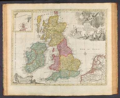


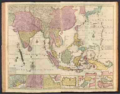


![[Übersichtskarte].](https://www.davidrumsey.com/rumsey/Size2/RUMSEY~8~1/199/14401021.jpg)


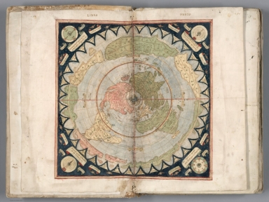
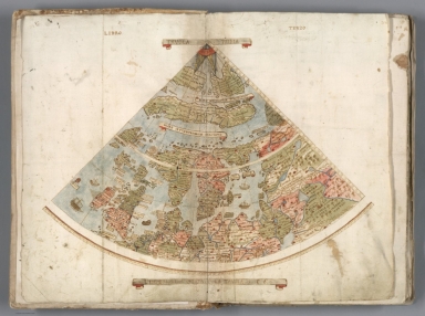
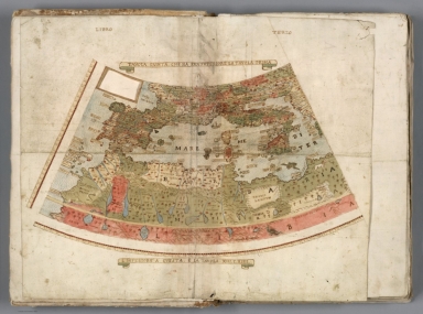


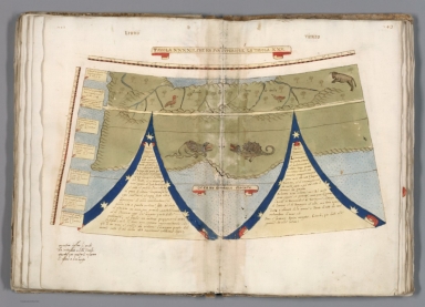
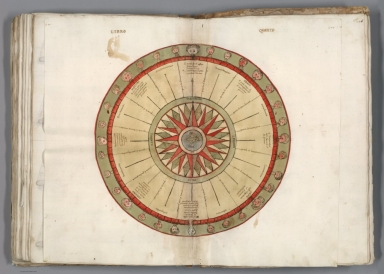

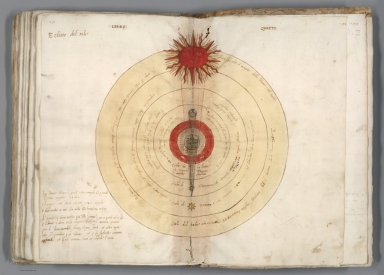


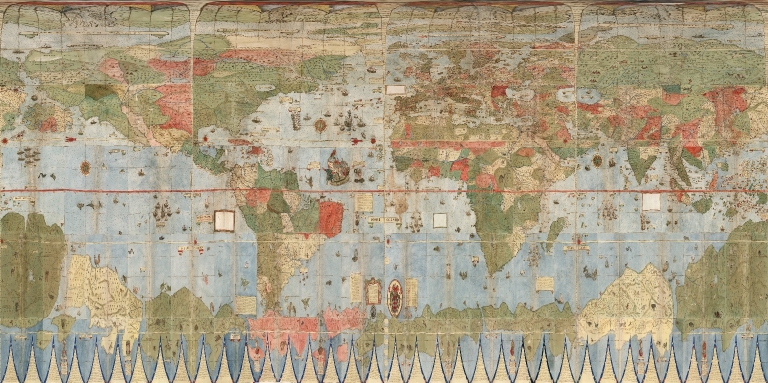
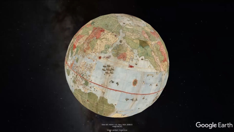


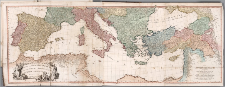


![Covers: [Composite World Atlas]](https://www.davidrumsey.com/rumsey/Size1/RUMSEY~8~1/199/15185001.jpg)


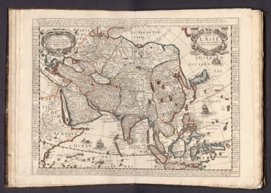


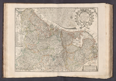

![[Piemonte]](https://www.davidrumsey.com/rumsey/Size2/RUMSEY~8~1/199/15185036.jpg)
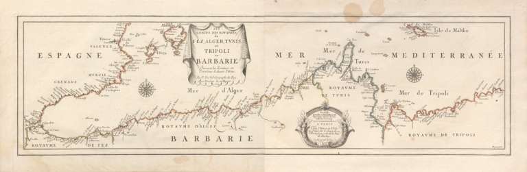


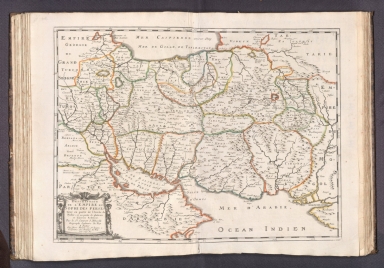


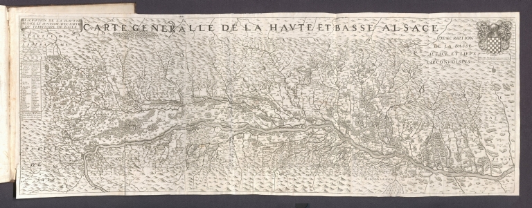


![Covers: [Un libro de mapas.]](https://www.davidrumsey.com/rumsey/Size2/RUMSEY~8~1/199/14368001.jpg)
