|
REFINE
Browse All : Wall Map of Georgia
1-1 of 1
Author
[Early, Eleazer, Sturges, Daniel]
Full Title
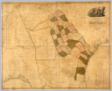
Map Of The State of Georgia Prepared from actual Surveys and other Documents for Eleazer Early By Daniel Sturges. Entered According to Act of Congress by Eleazer Early Proprietor. Engraved by Saml. Harrison 1818. Published & Sold By Eleazer Early Savannah Georgia and By John Melish & Samuel Harrison Philadelphia.
List No
4874.000
Note
Ristow mentions two editions with the same title, date and imprint, and with the later edition having "a number of changes and additions... in the southern Alabama portion of the map." We believe this copy is the first edition as we can detect no plate changes in the areas mentioned. This is the first large scale map of Georgia and it ranks in importance with the other large Southern State and Territory maps of the period: Wilson's South Carolina of 1822, Madison's Virginia of 1807 and 1818, Price and Strothers' North Carolina of 1808, and Vignoles' Florida of 1823. While it was undoubtedly the most accurate Georgia map when published, it quickly came under criticism by Tanner in his Geographical Memoir of 1823 for his American Atlas - he found the delineation of the Savannah River to be more correct in the Wilson 1822 Map of South Carolina. It has a lovely cartouche vignette, a table of distances, a statistical table, and "Remarks, Statistical and Geological." Streeter: "All in all an important and elaborate map of Georgia in the first part of the nineteenth century." Full color by county, without rollers.
1-1 of 1
|