|
Author
Rudolph, Emil
Full Title
Rudolph’s Map of Highland Park Lake County, Illinois.
List No
10650.004
Note
"This early 20th century real estate map shows the village of Highland Park, Illinois nestled between the border with Cook County in the south and the Fort Sheridan Military Reservation in the north. Several paste-downs containing updated property information have been added throughout the image, reflecting the map’s practical application and use. In other areas, colored pencil has been applied to highlight particular lots, including the Bob O’Link Golf Course (established 1916) and Northmoor Country Club (established 1918).
Author
Windes & Marsh
Full Title
Map of the Village of Glencoe Cook County, Ill.
List No
10650.005
Note
"Real estate map of the Village of Glencoe in Cook County, Illinois drawn to the scale of 200 feet to the inch. Glencoe was the first town in Illinois to use zoning codes, enacted in 1921. Shows individually numbered plots within labeled subdivisions and additions. Includes the location of the Skokie Country Club, which hosted the 1922 U.S. Open. Dated 1924 and published by the civil engineering/surveying firm of Windes & Marsh in Winnetka." (Curtis Wright, 2020)
Author
[Wolff, W.A., Roberts, C.N. & V.B., Windes & Marsh, Rudolph, Emil]
Full Title
(Real Estate Maps of Lake Forest, Wilmette, and Winnetka).
List No
10650.006
Note
"Six individual sheets make up this large composite real estate map covering much of Chicago’s North Shore area. Dated variously between 1907 and 1940. Map of the Village of Wilmette Cook County, Illinois. Sheet size: 42” x 17”. Originally published in 1934 with revisions to 1940. Drawn by W.A. Wolff and published by the village engineering department. Robert’s Map of the Village of Wilmette Cook County Ill. Sheet size: 20.25” x 11.5”. Undated, but likely published c. 1915 by C.N. & V.B. Roberts on behalf of the McGuire & Orr Real Estate Company. Includes portions of the Evanston and North Shore golf clubs. Map of Winnetka Cook Co. Ill. Sheet size: 21.5” x 17”. Dated 1911 and published by the civil engineering and surveying firm of Windes & Marsh. Includes a bold advertisement for the real estate firm of McGuire & Orr. Rudolph’s Map of Lake Forest Lake County, Illinois. Sheet size: 20.25” x 26.5”. Dated 1910 and surveyed/published by Emil Rudolph in Chicago. Includes manuscript annotations in pencil along the shores of Lake Michigan and features an advertisement for the real estate firm of McGuire & Orr. [North Chicago]. Sheet size: 12.5” x 16”. Annotations in red pencil in most of the lots. Untitled and undated survey of an area off Green Bay Road in North Chicago known as Downey (drawn from the road bisecting the image). Likely issued in Chicago c. 1915 by Emil Rudolph. Libertyville, Shields, Vernon, west Deerfield and Deerfield Townships, Lake County, Ill. Sheet Size: 26.5” x 29” Includes several areas that have been shaded in with red pencil. Dated 1907 and originally published in George Ogle’s Atlas of Lake County." (Curtis Wright, 2020)
Author
Schaeffer, M.B.
Full Title
Map of the North Shore being part of Lake and Cook Counties.
List No
10650.007
Note
"Detailed multi-purpose plan of an area in northern Illinois and southern Wisconsin along the shores of Lake Michigan. Incredibly detailed map of northeast Illinois and southeast Wisconsin from Winnetka to Kenosha. Most parcels of land are individually labeled according to the business or property owners, making this sheet useful for real estate, insurance, marketing, and promotional purposes. Prominent industries within Kenosha are identified in separate legend, while text boxes highlight major businesses in Waukegan. Transportation routes, including the Chicago, North Shore & Milwaukee Railroad, are also noted. An inset map at the top of the sheet shows the area served by the railway from Michigan City to Milwaukee.
Author
Brink, John G.
Full Title
Map of Lake County Ill. Published by Waukegan Daily Sun.
List No
10650.008
Note
"Real estate map of Lake County, from Highland Park to Winthrop Harbor and inland as far as Fox Lake. Shows a rapidly developing transportation system, schools, churches, cemeteries and the names of individual landowners. Includes manuscript annotations related to farms adjacent to Lake Michigan dated 1925." (Curtis Wright, 2020)
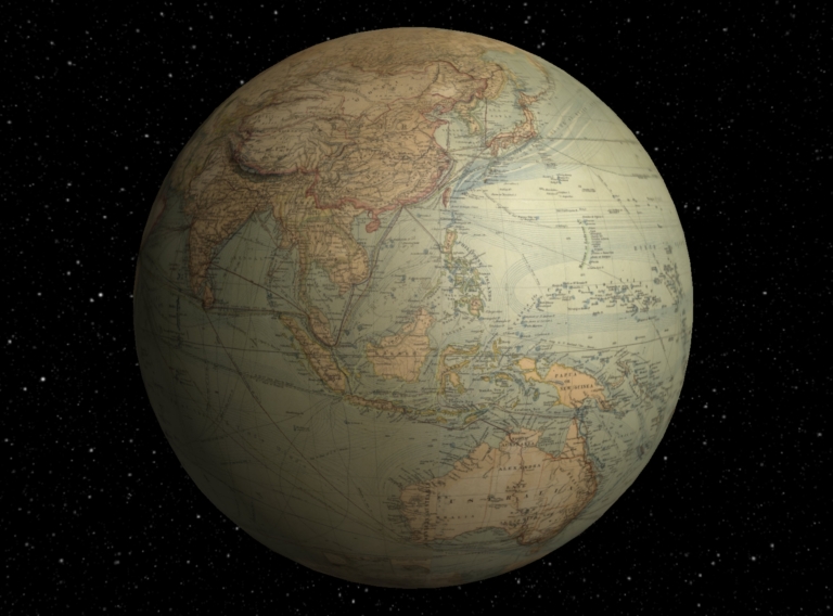
Author
Berghaus, Hermann
Full Title
(Interactive Globe) Chart Of The World On Mercators Projection. Constructed By Hermann Berghaus. Gotha: Justus Perthes. I. Edition 1863, X. Edition 1882. Engraved by H. Eberhardt, E. Kuhn and W. Weiler. (with 32 inset maps).
List No
3154.001
Note
Later edition, 1st ed. was 1863 (see our copy). Changes from the 1863 edition include: North and South American are now at the center of the map as opposed to the left side, many insets of cities, straits, islands, etc. are added, many more steamship lines and routes are shown, drift ice is indicated, and topography is updated in the western U.S. A dense and complicated map, more so, if that is possible, than the first edition. Printed in full color.
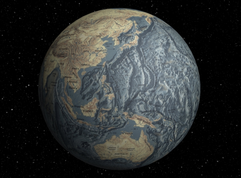
Author
[Heezen, Bruce C., Tharp, Marie, United States Navy Office of Naval Research, Lamonat Doherty Geological Observatory, de Rémur, Tanguy]
Full Title
(Interactive Globe) The Floor of the Oceans.
List No
7048.001
Note
Suitable for use in a seminar room; viewable up to 20 feet. Language(s): English. Map is plasticized paper. Mounted on wood rods. Prime Meridian is Greenwich. Projection is Mercator. Topics include: topography of land and ocean floors. Department of Geography, University of California at Berkeley, Call Number 1-F-3.
Author
Turnbull, Benjamin Corbett
Full Title
Map Of San Francisco Exhibiting the General Proportion of Brick And Stone Frame Buildings Throughout the City. San Francisco, 1874.
List No
10545.000
Note
Much of the original blue coloring survived but the yellow and the red were largely faded before restoration. The yellow and red colors have been filled in based on information on the map itself and other sources of information on building types.
Author
British Overseas Airways Corporation
Full Title
The Air Age Map of the World centred on London. / Compiled by the British Overseas Airways Corporation.
List No
10539.000
Note
Date estimated.
Author
[Scandinavian Airlines System, Uthaug, Jorleif]
Full Title
(Composite of Sheets 1-9) SAS The Global Airline.
List No
10409.010
Author
[Scandinavian Airlines System, Uthaug, Jorleif]
Full Title
(Sheet 1) SAS The Global Airline.
List No
10409.001
Author
[Scandinavian Airlines System, Uthaug, Jorleif]
Full Title
(Sheet 2) SAS The Global Airline.
List No
10409.002
Author
[Scandinavian Airlines System, Uthaug, Jorleif]
Full Title
(Sheet 3) SAS The Global Airline.
List No
10409.003
Author
[Scandinavian Airlines System, Uthaug, Jorleif]
Full Title
(Sheet 4) SAS The Global Airline.
List No
10409.004
Author
[Scandinavian Airlines System, Uthaug, Jorleif]
Full Title
(Sheet 5) SAS The Global Airline.
List No
10409.005
Author
[Scandinavian Airlines System, Uthaug, Jorleif]
Full Title
(Sheet 6) SAS The Global Airline.
List No
10409.006
Author
[Scandinavian Airlines System, Uthaug, Jorleif]
Full Title
(Sheet 7) SAS The Global Airline.
List No
10409.007
Author
[Scandinavian Airlines System, Uthaug, Jorleif]
Full Title
(Sheet 8) SAS The Global Airline.
List No
10409.008
Author
[Scandinavian Airlines System, Uthaug, Jorleif]
Full Title
(Sheet 9) SAS The Global Airline.
List No
10409.009
Author
Greenleaf, Moses, 1777-1834
Full Title
Map Of The State Of Maine With The Province Of New Brunswick By Moses Greenleaf. Engraved by J.H. Young & F. Dankworth, Philadelphia. Published by Shirley & Hyde, Portland 1829. Entered ... 29th day of February 1828 by Moses Greenleaf ... Maine. (inset) Map of Nova Scotia and Gulf of St. Lawrence.
List No
10405.000
Note
First edition. With black top and bottom rollers. Full color by county. Relief shown by hachures. Shows counties, settlements, townships, roads, water features, and railroads. Prime meridian London. See our 1844 and 1846 editions.
Author
Mancini, Raffaele
Full Title
Mappamondo costrutto su quello di Gardner, accresiuto di tutte le nuove scopoerte e Dedicato A.S. M. Ferdinando II Re del Regno dell Due Sicile
List No
10406.000
Note
Eight sheets joined. Based on James Gardner's 1825 world map (see our 4755.000) but updated. "Monumental Wall Map of the World, published by Official State Engineer Raffaele Mancini in Naples and dedicated to the King of the Two Sicilies. This colossal production was created specially for the court of King Ferdinando II of the Two Sicilies. It provides a remarkably large image of globe during the 1830s, a time of great transition and development, particularly in the Americas, Africa and Oceania. A sumptuous, expensive production, it was issued in only a very small print run, and is today exceptionally rare, this being 1 of only 3 known surviving examples. In creating the present map, Mancini employed James Gardner's 1825 World map as a model, although, with significant cartographic updates. Gardner drew his cartographic details from Aaron Arrowsmith's 1814 World Map on a Globular Projection featuring 36-inch hemispheres. Mancini's production is done to the same gargantuan scale as Gardner's map, which is regarded as perhaps "one of the largest World Maps produced in the early 1800's". His map represents one of the last great examples of Italian royal court patronage of cartography in Italy, which for centuries had maintained a tradition responsible for many of the world s finest and most historically important maps and globes. The production of the present map would have been very expensive and labor intensive, and would certainly have been funded as a special commission for the court of Ferdinando II. " (Ruderman)
Author
Weiss, Franz von (1791-1858)
Full Title
(Composite Map.) Carte der Europaeischen Tuerkey nebst einem Theile von Kleinasien in XXI. Blattern.
List No
12291.023
Note
A composite map of this 21-sheet wall map.
Author
[Wong, J. P., Huapei Huang]
Full Title
Mei guo san fan shi hua qiao qu : xiang xi tu = Map of San Francisco Chinatown. Published September, 1929. Compiled by J. P. Wong.
List No
10300.000
Note
Lithograph map with 2 insets, showing the extent of Chinatown in San Francisco and, in the second inset map, the extent of Oakland's Chinatown. Drawn by J. P. Wong. The main map is in Mandarin and English. Oriented with north towards lower right. It is the first map made by Chinese Americans of San Francisco for the Chinese community. The map depicts the largest Chinatown in North America during the Roaring '20s, an especially dramatic period in the neighborhood's history. It shows city blocks and building lots, each with appropriate street address numbers. The map was made for the Benevolent Association also known as the Chinese Six companies formed in 1882. The map is horizontally centered on Grant Street the heart of the neighborhood, bordered by Bush Street, Broadway Street on the north, Powell Street on the west, and Montgomery Street on the east. The street names and a few properties are in English, all other Chinese businesses and residence are in Chinese. This copy with applied water color showing Chinatown as delineated in Willard B. Farwell's 1885 large folding map "Official map of Chinatown in San Francisco Chinatown" made for the Board of Supervisors reporting on the condition of the Chinese Quarter and the Chinese of San Francisco (see our 6714.000). The 1885 map was also issued in smaller size in the San Francisco Municipal Report of 1884-85 (see our 5807.000). The color scheme on this 1929 map appears to be updated significantly from the 1885 map. Some of the updating may relate to the rebuilding of Chinatown after the 1906 earthquake. It is possible that the color was not applied in the original publishing, but later by someone else.
Author
Boucher, Lucien (1889-1971)
Full Title
(Sheets1-8) Air France, Le Plus Grand Reseau du Monde. Perceval Paris Printed in France Ref: 22 - 183 /P/ 11-64.
List No
10284.009
Note
This is the scarce "blue" edition of Boucher's 8 sheet Air France world map. While generally the same design concept as the 1959 and 1961 "red" version (see our 10163.000), there are subtle differences throughout the map. At lower right border: Perceval Paris Printed in France Ref: 22 - 183 /P/ 11-64.
Author
Boucher, Lucien (1889-1971)
Full Title
(Sheets1-8) Air France, Le Plus Grand Reseau du Monde. Perceval Paris Printed in France Ref: 21 364 /P/ 3-61
List No
10163.009
Note
A composite of all eight sheets joined. A very large eight sheet map of the world showing air routes of Air France. This map was also issued in 1959 and we have a joined copy of that issue mounted on linen. This 1961 edition updates the 1959 edition, changing several of the air routes and adding new routes, for example the route to Honolulu. At Lower right border: Perceval Paris Printed in France Ref: 21 364 /P/ 3-61
Author
[Theodore Schauseil, Murphy & Bolanz]
Full Title
Official Map of the City of Dallas and Suburbs, Revised and Corrected to January 1911.
List No
10268.000
Note
Second revised edition. This copy not listed in OCLC. Murphy & Bolanz first issued this map in 1891 and published it in large and small scale editions over many years. This copy's scale is very large, 600 feet to 1 inch. Note printed in the upper left: "The second revised Edition of Murphy and Bolanz' Official Map of the City of Dallas, Texas, entered according to Act of Congress in the Year of 1911 by said Murphy and Bolanz in the Office of the Librarian of Congress at Washington, D.C....The Original having heretofore been entered in the Year 1891..." Shows all lots and identifies major land ownerships. Circles show 1/2 mile distances from the post office. Railroads and Street Car lines shown. A huge impressive map. Original courtesy Barry Ruderman and Boston Rare Maps.
Author
[Delagrive, L'Abbe Jean, Riolet, Claude Charles, Tardieu, P.F.]
Full Title
Environs de Paris levés géométriquement par M. l'Abbé de La Grive de la Société royale de Londres et géographe de la Ville de Paris, dédiés à M. le Marquis de Vatan, Prévôt des Marchands et à Messrs les Echevins de la Ville en 1740. Gravée par l'Auteur et par Cl. Ch. Riolet.
List No
10255.000
Note
Issued in 9 sheets, here all joined together as one very large wall map. It is likely that this copy was originally 9 separate sheets, each dissected into 4 parts, then the 36 parts were joined on new linen backing. Shows in detail the country around Paris, including Versailles.
Author
Blaeu, Joan, 1596-1673
Full Title
[Eastern Hemisphere]
List No
10151.004
Note
Description in a cartouche in the bottom right of the globe. 1 map : copperplate engraving on 12 sheets, hand colour. Dates estimated. This circular map filled the right half of Blaeu's enormous world map, which was published under the title 'Nova Totius Terrarum Orbis Tabula'. Although undated, the dedication to Gaspar de Bracamonte Guzmán, a Spanish representative at the Treaty of Westphalia, probably places the publication sometime around the conclusion of the treaty in 1648. As new information continued to arrive the map was revised multiple times, producing at least four different states. This is an impression of the first, pulled before Blaeu made major revisions to the depiction of China. As published, Blaeu's two maps were framed in a border filled with smaller terrestrial and astrological maps. Judging from the extant copies, the two hemispheres were often extracted from the map and, in this case, presented as separate sheets. In doing so, however, the compilers of the Klencke Atlas reversed the order in which the hemispheres are presented on Blaeu's sheet, presumably to give precedence to Europe.
Author
Blaeu, Joan, 1596-1673, cartographer, publisher.
Full Title
[Western Hemisphere]
List No
10151.005
Note
1 map : copperplate engraving on 12 sheets, hand colour. Description in a cartouche in the bottom left of the globe. This circular map filled the left half of Blaeu's enormous terrestrial wall map, which was published under the title 'Nova Totius Terrarum Orbis Tabula'. Although undated, the dedication to Gaspar de Bracamonte Guzmán, a Spanish representative at the Treaty of Westphalia, probably places the publication sometime around the conclusion of that treaty in 1648. As new geographical information continued to arrive in the Netherlands the map was revised multiple times, resulting in at least four different states. This is an impression of the first, pulled before Blaeu made major revisions to the other half of the plate. As published, Blaeu's two maps were framed in a border filled with smaller terrestrial and astrological maps. The two hemispheres were often extracted and presented as separate sheets, however, and in this case as individual pages of an atlas. In doing so, however, the compilers of the Klencke Atlas reversed the order in which the hemispheres are presented on Blaeu's sheet, presumably to give precedence to Europe.
Author
Blaeu, Joan, 1596-1673
Full Title
Europæ Nova Descriptio.
List No
10151.006
Note
1 map : copperplate engraving on 6 sheets, hand colour. Dedication to the civic council of Amsterdam in the top left corner, in a small cartouche supporting the city's arms. Cartouche at the left, explaining the methods used to calculate distance. Title at the bottom left, on a tablet surmounted with an allegorical figure of Europe, and flanked at the sides by the reclining gods of the Danube and Rhine, around whom are gathered representatives of various professions, including soldiers, burghers, scholars, sailors, labourers, and, at the right, cartographers. Note on the measurement of longitude at the right, in between an armilliary sphere and a small circular world map (centered on Europe and Africa). Map framed by three country-by-country descriptions of Europe, in Latin (left), Dutch (bottom) and French (right).
Author
Blaeu, Joan, 1596-1673
Full Title
Asiæ Descriptio Novissima.
List No
10151.007
Note
1 map : copperplate engraving on 6 sheets, hand colour. Title in the upper left corner of the map, in the central compartment of a cartouche illustrating a personification of Asia at the top, costume studies at the sides, and two unnamed river gods at the bottom. Information on measurements in the bottom left. Map framed by three descriptions of Asia in Latin (left), Dutch (bottom) and French (right), titled 'NOVA ASIÆ DESCRIPTIO', 'BESCHRYVINGE VAN ASIA', and 'Nouvelle Description de toute L'ASIE.' Each text ends with the imprint of Jodocus Hondius.
Author
Blaeu, Joan, 1596-1673
Full Title
Archipelagus Orientalis, Sive Asiaticus.
List No
10151.008
Note
1 map : copperplate engraving on 6 sheets, hand colour. Two inset maps in the bottom left corner, of the Bonin (?) and Solomon Islands. Title at the bottom, on a tablet surmounted with a personification of Asia (?), below which two unnamed river gods lie in front of animals and small groups of standing figures in local costume. Map framed by three descriptions of Southeast Asia in Latin (left), Dutch (bottom) and French (right), each ending with the imprint of Jodocus Hondius. Notes on measurements in a cartouche to the right of the title group, with Blaeu's signature below.
Author
[Blaeu, Joan, 1596-1673, Blommaert, Samuel, 1583-1651]
Full Title
Novissima Africæ Descriptio.
List No
10151.009
Note
1 map : copperplate engraving on 6 sheets, hand colour. Method of distance calculation presented in a cartouche in the top right. Small fictive sheet in the bottom left, held above the waves by sea putti, carrying an acknowledgement to Samuel Blommaert for information about the Cabo Blanco and Cabo Negro (Angola). Title in the bottom right, on a cartouche surmounted with a personification of Africa, and flanked by two river gods and various figures in regional dress (North African at the left, Sub-Saharan at the right). Map framed by three descriptions of the continent, in Latin (left), Dutch (bottom) and French (right), each ending with the imprint of Jodocus Hondius. Samuel Blommaert served three terms as director of the Dutch West India Company, and he also oversaw voyages to North America and Africa. His papers proved to be a fruitful source of information about the west coast of Africa, and even after his death in 1651 he continued to be credited by cartographers, particularly for supplying details about the two capes mentioned by Blaeu in his acknowledgement (for a similar posthumous note see Maps K.Top.117.30.). Among the numerous animals depicted in the African interior are two rhinoceros based on Albrecht Dürer's famously misleading woodcut, which for centuries remained the stock image of the animal.
Author
Blaeu, Joan, 1596-1673
Full Title
America Septentrionalis.
List No
10151.010
Note
1 map : copperplate engraving on 6 sheets, hand colour. Decorative cartouche in the top left corner, containing a circular map of the Arctic oriented with north at the right. Accompanied by a short Latin description in the left half of the cartouche, over a blank portion of the map. Title in the bottom left corner, on a tablet surmounted by a personification America, who brandishes a bow and arrow and hosts a parrot in her feather crown. Below, flanking the tablet, are two unnamed river gods, accompanied by indigenous animals and various figures in regional dresses. Information on distance in the bottom right corner, above Blaeu's imprint. Map surrounded by three descriptions of North America, in Latin (left), Dutch (bottom) and French (right), each carrying the imprint of Jodocus Hondius.
Author
Blaeu, Joan, 1596-1673
Full Title
America Meridionalis.
List No
10151.011
Note
1 map : copperplate engraving on 6 sheets, hand colour. Inset map of the Tierra del Fuego in the bottom left corner, in a cartouche topped with a voluted pediment and flanked with fruit swags suspended from consoles. Information on distance on a tablet at the bottom of the map, above Blaeu's imprint, with four birds perching on the cornice at the top. Title in the bottom right corner, surmounted by a personification of America, bow and club in hand, who straddles the remains of a cadaver. Below, either side of the title, are two river gods and an assortment of animals and figures in native dress. Map surrounded by three descriptions of the continent, in Latin (left), Dutch (bottom) and French (right), each carrying the imprint of Jodocus Hondius.
Author
[Nolli, Giovanni Battista, Pozzi, Stefano]
Full Title
Alla Santita' Di Nostro Signore Papa Benedetto XIV La Nuova Topografia Di Roma Ossequiosamente Offerisce E Dedica L'Umilissimo Servo Giambattista Nolli Comasco.
List No
10113.001
Note
Plan of Rome on 12 sheets, here originally assembled as a wall map. Nolli was an Italian architect and surveyor. He began surveying for his Rome map in 1736 and engraved it in 1748. The map was published in response to the commission of Pope Benedict XIV to survey Rome in order to help create demarcations for the 14 traditional rioni or districts. It was by far the most accurate description of Rome produced to date at the time. For decades it continued to be used as a base map for many of the maps of Rome that followed it. Stefano Pozzi engraved the views at the bottom of the map.
Author
[Nolli, Giovanni Battista, Pozzi, Stefano]
Full Title
Indice De Numeri Della Pianta
List No
10113.002
Note
Four index sheets joined vertically to accompany the Plan of Rome on 12 sheets, here originally assembled as a wall map. Nolli was an Italian architect and surveyor. He began surveying for his Rome map in 1736 and engraved it in 1748. The map was published in response to the commission of Pope Benedict XIV to survey Rome in order to help create demarcations for the 14 traditional rioni or districts. It was by far the most accurate description of Rome produced to date at the time. For decades it continued to be used as a base map for many of the maps of Rome that followed it. Stefano Pozzi engraved the views at the bottom of the map.
Author
Anonymous
Full Title
(Taisho Japanese map of the world. Taisho Japanese map of Japan and Korea). (9 insets).
List No
11670.000
Note
Wall map of the world commemorating Japanese involvement in World War I on sheet 190x87. Mounted on bamboo rods framed with decorative cloth. In 2 parts: The upper part showing double hemisphere projection map of the world, omitting the Antarctic and any small islands, with numerous portraits of world leaders, most of whom were in power during the first world war. At center is an image of the Japanese Emperor Taisho. The top left corner is an image of someone made to look like Emperor Jimmu, the 1st emperor of Japan. The top right corner is an image of Emperor Meji (1868 – 1912), who preceded Taisho and is known for moving the capitol to Edo (present day Tokyo). Other world leaders shown above the map include King George V (Great Britain) Tsar Nicolas II (Russia), Sultan Mehmed V (Ottoman), Franz Joseph (Austria – Hungary), Woodrow Wilson (United States of America), and Albert I (Belgium), to name a few. The lower part Includes map of Japan and Korea with 9 insets: including map of the world during WWI, map of Taiwan, map of the north extension of Kurile Islands, etc. Includes legend. Date estimated 1918.
Author
Henry, Everett
Full Title
Our United States.
List No
10061.000
Author
[Stucchi, Stanislao (approximately 1780), Strass, Friedrich, 1766-1845]
Full Title
Nuovo Quadro Cronologico-Storico Universale Della pui rimota antichita sino al presente 1826. Publicato in Milano dall'incisore Stanislao Stucchi.
List No
12314.000
Author
Flocchi, Pietro
Full Title
Grand' Albero Genealogico Storico Dei Popoli Italiani.
List No
12315.000
Author
Wisner de Morgenstern, Francois, 1804-1878
Full Title
(Composite Map) Carte Topographique de la Republique du Paraguay. Carte originale vaite de 1846 a 1858 par des procedees triganometriques et astronomiques dedie au honorable Congres Legilative de la Nation par le Colonel du Genie Francois Wisner de Morgenstern . . . 1873.
List No
12362.003
Author
Boschke, Albert
Full Title
Map of Washington City, District of Columbia. Seat of the Federal Government. Respectfully Dedicated to the Senate and the House of Representatives of the United States of North America. Surveyed and published by A. Boschke, C.E. 1857.
List No
12363.000
Author
Bowers, A.B.
Full Title
Map Of Sonoma County California. Made and Published by A.B. Bowers, In Accordance with an Act of the Legislature, approved 28 March 1863, With Additions and Corrections to The Date of Publication. E. Fletcher Lith. 308 Front St. S.F. (with 4 inset maps).
List No
10080.000
Note
First edition, not listed by Vodges - he lists the 1867 second edition, see our 4222.000. With four inset maps of towns. This is the earliest wall map of Sonoma County that we have seen.
Author
Klemm, Josef
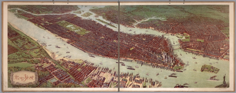
Full Title
New York. Ad. Lehmann's geogr. Charakterbilder. Verlag F. E. Wachsmutg, Leipzig.
List No
10050.001
Note
Date estimated based on presence of Singer Building of 1908 and absence of MetLife Tower of 1909 (thanks to Piotr Tarczynski for pointing this out to us). Birds-eye view of Manhattan and greater New York. From askArt: "Josef Ferdinand Klemm (Austrian, 1868-1916) was a noted painter, lithographer, designer and image restorer. He is primarily known for his finely detailed designs of cultural and historical mural study-decorations for schools that included landscapes, cityscapes, medieval cities, the Acropolis (Greece), various architectural renderings, memorial and national monuments, interior scenes, historical and cultural human genre/civil activities, as well as educational/industrial cut-away diagrams/wall-charts, geographical scenes, etc. Josef Klemm was born December 25, 1868 in Vienna, Austria to the Austrian bookseller and publisher Joseph Klemm (Austrian, b. Apr. 4, 1821-d. Feb. 27, 1882) and Johanna (née Fessl) Klemm." This copy came from a school in Helsinki, Finland.
Author
[Longchamp, Sebastian G., Janvier, Jean Denis]
Full Title
L'Amérique divisée en tous ses pays et etats, dressée sur de nouveaux mémoires et sur les dernières observations.
List No
8683.000
Note
"Important 18th Century wall map of America, one of the earliest obtainable printed maps to show the Sea or Bay of the West and the earliest wall map of America to show this configuration. The map is oriented with east at the top, one of only a few maps to present America in this configuration and unquestionably the largest and most decorative...The map is surrounded by decorative vignettes which depict important events in American History. It is noteworthy for both its decorative quality and early depiction of the Sea or Bay of the West, as well as the curious east at the top projection, which may simply have been a convenience for making the map relatively uniform to the sizes of Longchamp's wall maps of Asia, Africa, and Europe." (Ruderman)
Author
Strass, Friedrich
Full Title
Der Strom der Zeiten oder bildliche Darstellung der Weltgeschichte von den altesten Zeiten bis zum Ende des achtzehnten Jahrhundeits Von Friedrich Strass. Porfesser der Gefchichte am Koniglichen ... (The stream of time or bildtiche Daistelling of world history from the most ancient times until the end of the eighteenth century By Friedrich Strass. Professer the Gefchichte at the royal ..)
List No
7921.000
Note
This timeline by Austrian chronologer Strass was highly influential and was translated into several languages, as well as spawning later variants by J.H. Colton and William Bell (see our copies). A second issue was published in 1804.
Author
Callot, Jacques (1592-1635)
Full Title
(The Siege of the Citadel of Saint Martin on the Isle de Re)
List No
8685.000
Note
These are a set of six prints illustrating the Siege of the Citadel of Saint Martin on the Isle de Re. Callot also engraved the Seige of La Rochelle at the same time, also in six prints with decorative borders (Lieure 655). Both are remarkable, but the Seige of Saint Martin view is extraordinary in its use of engraving line darkness to indicate depth of space, a technique that Callot pioneered. These famous battle scenes were drawn and etched by Callot as bird's-eye views and maps. Callot received commissions to commemorate these two spectacular battle scenes from Louis XIII in 1628. The Siege of La Rochelle and St. Martin on the L'Ile de Re took place between the French Royal forces of Louis XIII and the Huguenots of La Rochelle and the English forces of Charles I at St. Martin in the years 1625-1628. The Siege of Saint-Martin-de-Ré, occurred in the French isle of Ile de Ré around the fortress of the city of Saint-Martin-de-Ré, when Duke of Buckingham tried to occupy the island in 1627. After three months of combat and sieges however, Governor Toiras and a relief force of French ships and troops managed to repel the Duke of Buckingham, who was forced to withdraw in defeat. This encounter followed another defeat for Buckingham, the 1625 Cádiz Expedition, and is considered as the opening conflict of the Anglo-French War of 1627-1629, itself a part of the Thirty Years' War.
Author
North American Press Ass'n
Full Title
The Exposition City San Francisco. Copyright By North American Press Ass'n 1912 Hearst Bldg. S.F. Pingree-Traung Co. Lith. S.F.
List No
10015.000
Note
This map provides a detailed view of the extraordinary rebuilding of downtown San Francisco only six years after the devastating earthquake and fire of 1906. Just a few lots remain unbuilt. It is a scarce map that was issued in two forms: on thin paper as a folded map with the Supplement to the San Francisco Standard Guide, and on thicker paper unfolded (our copy, linen backed as a wall map). A reduced size reproduction of the copy at the San Francisco Society of California Pioneers Library was issued in 1968 (see our 10016.000). The Panama Pacific Exposition of 1915 is shown prospectively. A second issue of this larger map is at the Wells Fargo Museum in San Francisco - it adds a winding road going up Mount Tamalpais as well as names of buildings on the block bounded by First, Bryant, Brannon, and Beale streets.
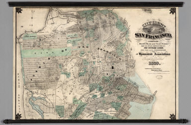
Author
Goddard, George H.
Full Title
City and County of San Francisco. Compiled from U.S. Land and Coast Surveys from the Official Surveys of the City, The Outside Lands. The Tide Land Commission and the Homestead Associations by George H. Goddard C.E. 1869. Lithographed & Published by Britton & Rey, Corr. Commercial & Leidesdorff Sts. S. Entered ... 1869.
List No
7819.000
Note
Shows in tint the tidelands, homestead areas, parks, and cemeteries. There is property information and street layouts that appear to be unique to this map, compared to other San Francisco maps of the same period. Wall map mounted on linen with decorative black sticks at top and bottom.
|


![[Eastern Hemisphere]](https://www.davidrumsey.com/rumsey/Size2/RUMSEY~8~1/179/10151004.jpg)
![[Western Hemisphere]](https://www.davidrumsey.com/rumsey/Size2/RUMSEY~8~1/179/10151005.jpg)