|
REFINE
Browse All : View of Virginia and North Carolina
1-4 of 4
Author
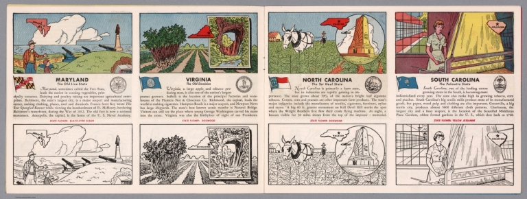
[Fisher, Joseph R., Planters Peanuts (Firm)]
Full Title
Maryland : The old line state -- Virginia : The old dominion -- North Carolina : The tar heel state -- South Carolina : The palmetto state.
List No
14374.006
Note
Four views, representing Maryland, Virginia, North Carolina and South Carolina. Views show examples of the landscape and natural resources. Each view includes an inset map of the state, which marks the location of the capital city with a star. Accompanied by descriptive text, the state flags, seals and flowers: black-eyed Susan, dogwood, dogwood and yellow jessamine, respectively. The view of each state appears both in color (on top) and in black and white (bottom), the latter inviting coloration. Together, views are 18 x 52 cm, on two sheets 20 x 54 cm.
Author
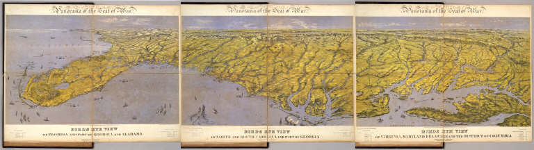
Bachmann, John
Full Title
(Composite of) Panorama of the Seat of War. Birds eye view of Florida and part of Georgia and Alabama .. North and South Carolina and part of Georgia .. Virginia, Maryland, Delaware and the District of Columbia. John Bachmann, Publisher, 115 & 117 Nassau St., New York. Entered ... 1861 by John Bachmann ... New York. Drawn from Nature and Lith. by John Bachmann.
List No
5491.000
Note
Composite map image from three separate issues.
Author
United States. War Department
Full Title
Federal Point, N.C. Fort Pemberton near Greenwood, Miss. Topographical map of the country and vicinity of New Berne, N.C. Compiled under the direction of Lieut. W.R. King ... Made by Solon M. Allis ... May 1864. Plan of defensive works at Harrisons Landing, Sept. 21st, 1864. Powder vessel exploded off Fort Fisher, N.C. Sheet no. 1. Plan, section and elevation of board loop-hole on our picket line. Official: Peter S. Michie ... February 20th 1865. No. 3. Union defensive lines, Deep Bottom, Va. ... October 26th 1864. Hdqr. Army of the Potomac, Engineer Department. Sketch showing the position west of the Weldon Railroad ... N. Michler ... October 8th 1864. Sketch showing the positions of the redoubts and batteries of the lines of the U.S. forces in front of Petersburg, Va. ... Sept. 13th, 1864. Official: N. Michler ... Lookout and signal tower at Crow's Nest near Bermuda Hundred, Va. Julius Bien & Co., Lith., N.Y. (1891-1895)
List No
1780.067
Note
7 col. maps and 3 b&w drawings. Relief shown by hachures; depths by soundings. Accompany documents by Thomas L. Casey, W.W. Loring, P.S. Michie and G. Weitzel.
Author
United States. War Department
Full Title
No. 1. Defensive lines, 18th Army Corps from Fort Brady to Fort Burnham, Battery Harrison ... October, 1864. Engineer's Office, Military Division of the Gulf. Map no. 4. Battle-field of Five Forks, Va. fought Saturday April 1st 1865. Union forces commanded by Maj. Gen. P. H. Sheridan, U.S.A. Surveyed, drawn and lithographed under direction of ... G.L. Gillespie ... July 1865. Surveyed and drawn by Henry C. Koch. Drawn for stone by F. D'Avignon. (with) Defensive lines, 10th Army Corps from Fort Burnham, Battery Harrison, to right of New Market Road ... October 1864. Official: Peter S. Michie. (with) Redoubt and signal station on Cobb's Hill, Va. No. 4. (with) Battle of Bentonville, N.C., fought March 19th, 1865. (with) No. 4. Map showing position of pontoon bridge on which the Army of the Potomac crossed the James River, June 14th and 15th 1864. Approved G. Weitzel. (with) Chart of the obstructions in the Cape Fear and Brunswick rivers and the batteries commanding them. (with) Plan, section and elevation of casemate in Fort Burnham, January 1865. Official: W.R. King. (with) Plan of the cantonment of the 1st Brigade, 7th Division, Cavalry Corps, Military Division of the Mississippi at Gravelly Springs, Ala., in January and February 1865. Julius Bien & Co., Lith., N.Y. (1891-1895)
List No
1780.068
Note
Two col. maps with 5 col. ancillary maps and 2 b&w drawings. Relief shown by hachures. Accompany documents of P.S. Michie, P.H. Sheridan, G. Weitzel, Braxton Bragg and J.H. Wilson.
1-4 of 4
|