|
REFINE
Browse All : View and Land Development of San Francisco (Calif.)
1-11 of 11
Author
[Commercial Club of Chicago. Civic Committee, Burnham, Daniel Hudson, 1846-1912, Bennett, Edward H. (Edward Herbert), 1874-1954, Moore, Charles]
Full Title
XXIX. Plan for the development of the entire city of San Francisco / Report of D. H. Burnham to the Association of Improvement and Adornment of San Francisco, 1904-1906 -- XXX. Bird's-eye view of the plan of development for San Francisco.
List No
14346.029
Note
Map and bird's-eye view of San Francisco within second chapter to Plan of Chicago. Map and view show roads, parks, coastlines, bay and vicinity. Maps includes a bar scale, with north oriented toward top of map. With descriptive text for view: This view shows municipal center, boulevard system, and treatment of surrounding hills as parks. Black and white engravings. Together, map and view are 20 x 16 cm, on sheet 24 x 31 cm. (Page number inferred.) Chapter spans pages 9-30.
Author
[Bennett, Edward H., Burnham, Daniel Hudson, 1846-1912, Meryon, Charles]
Full Title
(Preface to) Report on a plan for San Francisco by Daniel H. Burnham. Assisted by Edward H. Bennett. Presented to the Mayor and Board of Supervisors by the Association for the Improvement and Adornment of San Francisco. Edited by Edward F. O'Day. September, MCMV. Published by the City.
List No
1625E
Note
First page of preface. Small "Etching by Meryon, 1855" at top of sheet.
Author
[Bennett, Edward H., Burnham, Daniel Hudson, 1846-1912]
Full Title
Bird's-eye perspective of the City from Twin Peaks, showing the proposed changes. (By Daniel H. Burnham. Assisted by Edward H. Bennett. 1905)
List No
1625.005
Note
Photographic reproduction of map.
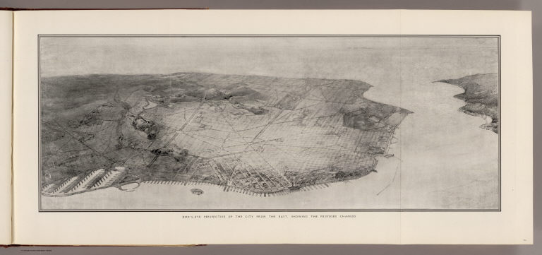
Author
[Bennett, Edward H., Burnham, Daniel Hudson, 1846-1912]
Full Title
Bird's-eye perspective of the City from the east, showing the proposed changes. (By Daniel H. Burnham. Assisted by Edward H. Bennett. 1905)
List No
1625.006
Note
Photographic reproduction of map.
Author
[Bennett, Edward H., Burnham, Daniel Hudson, 1846-1912]
Full Title
Plan of Civic Center. (By Daniel H. Burnham. Assisted by Edward H. Bennett. 1905)
List No
1625.023
Note
Uncolored map.
Author
[Bennett, Edward H., Burnham, Daniel Hudson, 1846-1912]
Full Title
View of Civic Center, looking from the south side of Market Street. (By Daniel H. Burnham. Assisted by Edward H. Bennett. 1905)
List No
1625.024
Note
Uncolored bird's-eye view showing buildings, column, streets, etc.
Author
[Bennett, Edward H., Burnham, Daniel Hudson, 1846-1912]
Full Title
Telegraph Hill, looking east, showing suggested architectural treatment. (By Daniel H. Burnham. Assisted by Edward H. Bennett. 1905)
List No
1625.038
Note
Photographic reproduction of drawing.
Author
[Bennett, Edward H., Burnham, Daniel Hudson, 1846-1912]
Full Title
View of the proposed drill ground from the heights, looking northeast (San Francisco Presidio. By Daniel H. Burnham. Assisted by Edward H. Bennett. 1905)
List No
1625.039
Note
Photographic reproduction of drawing.
Author
[Bennett, Edward H., Burnham, Daniel Hudson, 1846-1912]
Full Title
Approach to Twin Peaks as seen from Market Street. (By Daniel H. Burnham. Assisted by Edward H. Bennett. 1905)
List No
1625.040
Note
Photographic reproduction of drawing.
Author
[Bennett, Edward H., Burnham, Daniel Hudson, 1846-1912]
Full Title
Map showing San Francisco wate-front in early days.
List No
1625.048
Note
Lithographed map. Relief shown by contours (interval: 20 ft.) and hachures.
Author
[Bennett, Edward H., Burnham, Daniel Hudson, 1846-1912]
Full Title
Mission Plank Road, Southwest fron Ninth, 1856
List No
1625.049
1-11 of 11
|