|
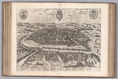
Author
Munster, Sebastian, 1448–1552
Full Title
Egrana ciuitas
List No
15058.202
Author
Munster, Sebastian, 1448–1552
Full Title
Constantinopolitanae
List No
15058.217
Author
Munster, Sebastian, 1448–1552
Full Title
Jerusalem
List No
15058.224
Author
Munster, Sebastian, 1448–1552
Full Title
Il Cuscho Citta Principali Della Provincia Del Peru
List No
15058.234
Author
[Suomen Maantieteellinen Seura, Tilgmann, Ferdinand, 1832-1911]
Full Title
No. 26. Majakat. = Fyrar. Aktiebolaget F. Tilgmann, Helsingfors 1898.
List No
14366.038
Note
Thematic map of Finland. Features lighthouses, showing the range of light they produce, in 1898. Also shows cities, railways, bodies of water, drainage, coastlines and islands. Includes latitudinal and longitudinal lines, as well as a legend (including pasted correction), bar scale and scale statement. With view: [Featured Finnish lighthouses]. Colored lithograph. Map is 39 x 50 cm, on double sheet 43 x 60 cm. Text presented in parallel Finnish and Swedish.
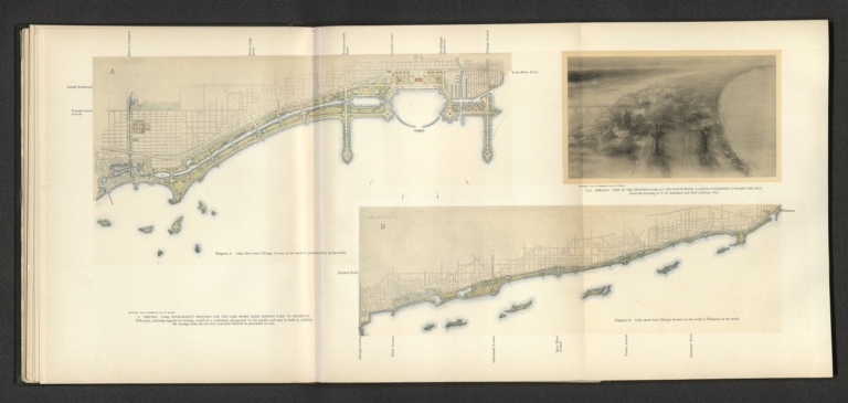
Author
[Commercial Club of Chicago. Civic Committee, Burnham, Daniel Hudson, 1846-1912, Bennett, Edward H. (Edward Herbert), 1874-1954, Moore, Charles, Lathrop, Paul]
Full Title
L. Chicago : Park development proposed for the lake shore from Jackson Park to Wilmette : Diagram A. Lake shore from Chicago Avenue on the north to Jackson Park on the south - Diagram B. Lake shore from Chicago Avenue on the south to Jackson Park on the north -- L(a). Chicago : View of the proposed park on the south shore, looking northwest towards the city / From the drawing of D. H. Burnham and Paul Lathrop, 1896.
List No
14346.048
Note
Two maps and one view of Chicago within fourth chapter to Plan of Chicago. Maps show roads, topography, parks, drainage, shoreline and harbor. Relief shown pictorially. With descriptive text: This park, enclosing lagoons for boating, would be a continuous playground for the people ... Colored lithograph. Together, maps and view are 25 x 60 cm, on fold-out sheet 31 x 68 cm. Chapter spans pages 43-60.
Author
[Commercial Club of Chicago. Civic Committee, Burnham, Daniel Hudson, 1846-1912, Bennett, Edward H. (Edward Herbert), 1874-1954, Moore, Charles]
Full Title
CXIII. Chicago : Plan of Michigan Avenue from Twelfth Street to the River, and its extension on Pine Street to Chicago Avenue. -- CXIV. Chicago : Proposed boulevard and parkway on Michigan Avenue and Pine Street : View looking west across Grant Park, showing the relation of the park to the boulevard.
List No
14346.090
Note
Black and white map and bird's-eye view of Chicago within seventh chapter to Plan of Chicago. Map shows a proposed roadway, as well as buildings, parks, fountains and the Chicago River. View shows buildings, roads, bridges, parks, fountains, the Chicago River, the shoreline of Lake Michigan and ships. With descriptive text for map: The proposed double roadway is designed to accommodate the immense volume of traffic which will be attracted to the Lake front ... Map is 8 x 43 cm, and view is 9 x 19 cm, on double sheet 31 x 48 cm. (Page numbers inferred.) Chapter spans pages 99-118.
Author
[Canet Alvarez, Gerardo A., 1911-, Raisz, Erwin, 1893-1968, Harvard University. Institute of Geographical Exploration, Cuba. Ministerio de Agricultura]
Full Title
Oceanografia.
List No
14350.012
Note
Maps showing ocean surrounding Cuba. Title translates to: Oceanography Features ocean depths and currents surrounding the country. With three cross section views showing the landscape beneath the ocean surface. Includes illustrations, charts of ocean temperature and an illustration depicting the cycle of life underwater. Accompanied by descriptive text, which appears in Spanish, with English translations.
Author
[Canet Alvarez, Gerardo A., 1911-, Raisz, Erwin, 1893-1968, Harvard University. Institute of Geographical Exploration, Cuba. Ministerio de Agricultura]
Full Title
Geologia.
List No
14350.013
Note
Maps showing the geology of Cuba. Title translates to: Geology Features distribution of geological characteristics in the country. With ten cross section views showing the geologic terrain beneath the landscape surface. Includes a legend and illustrations. Accompanied by descriptive text, which appears in Spanish, with English translations.
Author
[Canet Alvarez, Gerardo A., 1911-, Raisz, Erwin, 1893-1968, Harvard University. Institute of Geographical Exploration, Cuba. Ministerio de Agricultura]
Full Title
Geomorfologia.
List No
14350.014
Note
Maps showing the geomorphology of Cuba. Title translates to: Geomorphology Features distribution of geomorphology in the country, as well as topography and drainage. Relief shown pictorially. With eight cross section views showing the geomorphological terrain beneath the landscape surface. Accompanied by descriptive text, which appears in Spanish, with English translations.
Author
[Canet Alvarez, Gerardo A., 1911-, Raisz, Erwin, 1893-1968, Harvard University. Institute of Geographical Exploration, Cuba. Ministerio de Agricultura]
Full Title
Suelos.
List No
14350.015
Note
Maps showing the soil of Cuba. Title translates to: Soils Features distribution of soil types in the country. With six cross section views showing the soil layers beneath the landscape surface. Map indexed, with key at left. Includes a legend and illustrations. Accompanied by descriptive text, which appears in Spanish, with English translations.
Author
[Canet Alvarez, Gerardo A., 1911-, Raisz, Erwin, 1893-1968, Harvard University. Institute of Geographical Exploration, Cuba. Ministerio de Agricultura]
Full Title
Recursos forestales -- Pesca.
List No
14350.016
Note
Two maps showing the forests and fishing of Cuba. Titles translate to: Forest resources -- Fishing Features distribution of fishing locations in the country. With diagrams and illustrations. Accompanied by descriptive text, which appears in Spanish, with English translations.
Author
[Canet Alvarez, Gerardo A., 1911-, Raisz, Erwin, 1893-1968, Harvard University. Institute of Geographical Exploration, Cuba. Ministerio de Agricultura]
Full Title
Vegetacion.
List No
14350.017
Note
Map showing the vegetation of Cuba. Title translates to: Vegetation Features distribution of different vegetation types in the country. Includes a bar scale. With views of different vegetation types. Accompanied by descriptive text, which appears in Spanish, with English translations. (Page numbers inferred.)
Author
[Canet Alvarez, Gerardo A., 1911-, Raisz, Erwin, 1893-1968, Harvard University. Institute of Geographical Exploration, Cuba. Ministerio de Agricultura]
Full Title
Patron de vida.
List No
14350.019
Note
Map showing the human geography of Cuba. Title translates to: Life patterns Features roads, railways, population and water consumption in the country. Includes a bar scale. With views comparing urban and rural communities. With charts depicting the economy, tracing changes in the twentieth century. Accompanied by descriptive text, which appears in Spanish, with English translations.
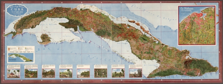
Author
[Canet Alvarez, Gerardo A., 1911-, Raisz, Erwin, 1893-1968, Harvard University. Institute of Geographical Exploration, Cuba. Ministerio de Agricultura]
Full Title
Mapa de los Paisajes de Cuba por Gerardo Canet con la colaboración de Erwin Raisz.
List No
14350.037
Note
Map of Cuba. Shows cities, roads, railways, topography, vegetation, drainage, coastline, lighthouses, islands and ocean depths. Relief shown pictorially. Includes latitudinal and longitudinal lines, as well as a legend and bar scale. With two inset maps: Tipos de paisajes [= Types of landscapes] -- La Habana y sus alrededores [= Havana and its surroundings]. In addition, with views depicting various ecosystem types, accompanied by descriptive text, which appears in Spanish, with English translations. Map is 53 x 146 cm, on fold-out sheet 56 x 151 cm.
Author
Masi, Giovanni Tommaso
Full Title
Planta della citta di Sant'Iago capitale del regno del Chili.
List No
14343.053
Note
Map of Santiago, Chile. Shows city and vicinity, roads, topography, vegetation and drainage. Relief shown pictorially. Includes an arrow indicating the direction of water flow, as well as a compass rose, with north oriented toward bottom of sheet. With inset view, showing Santa Lucía Hill: Veduta della piccola Montagna di Sa. Lucia. Map is indexed, with key at top. Black and white engraving, with title in decorative cartouche. Map is 19 x 20 cm, on sheet 37 x 25 cm. Descriptive text for map appears on page 14 of Dexcrizione delle carte geografiche, which precedes maps.
Author
Andriveau-Goujon, J.
Full Title
Tableau Comparatif et Figure de La Hauteur des Principales Montagnes et du Cours des Principaux Fleuves due Monde. Paris. Chez J. Goujon & J. Andriveau. Geographes - Editeurs. Rue du Bac, No. 6, Pres le Pont Royal. 1829. Fleuves graves par Dumortier. Les Montagnes par A. Hocquart. La Lettre par Arnoul. (to accompany) Atlas de choix ou Recueil de cartes de geographie ancienne et moderne.
List No
11124.045
Note
Comparative mountains and rivers charts, a convention developed in the 19th century. Beautifully colored with fine graphics and art and closely corresponding statistical tables. It presents an appealing balance in different colors. Extensive annotations on vegetation, volcanic activity, and lichen, no doubt derived from Humboldt. Of course, due to the early date, the geographical data does not reflect many later discoveries.
Author
[Lizars, William Home, Thomson, John]
Full Title
A comparative view of the lengths of the principal rivers of Scotland. (with) Comparative view of the height of the falls of Foyers and Corba Linn. Drawn by W.H. Lizars. Engd. by W.H. Lizars. Published by John Thomson, Edinburgh, 1831. (1832)
List No
5748.002
Note
Hand colored engraved view with 2 insets.
Author
[Chatelain Henri, 1684-1743, Gueudeville, Nicolas]
Full Title
Vue de la Ville du Grand Caire, et de ses environs. Tom. VI. No. 6. Pag. 21. (to accompany) Atlas Historique ... Tome VI. A Amsterdam, chez L'Honore & Chatelain Libraires. M DCC XIX (1719).
List No
13272.625
Note
Engraved views of Cairo and surroundings, showing Cairo from across the Nile, tower of the Roman aquaduct and Jacob's well. includes descriptive text.
Author
[Chatelain Henri, 1684-1743, Gueudeville, Nicolas]
Full Title
Vue de Tunis et d'Alger & de Gigeri : avec quelques particularitez touchant les moeurs de leurs habitants & de quelques autres peuples de Barbarie. Tom. VI. No. 10. Pag. 40. (to accompany) Atlas Historique ... Tome VI. A Amsterdam, chez L'Honore & Chatelain Libraires. M DCC XIX (1719).
List No
13272.642
Note
Engraved views depicting people and customs in Algeria and views of Gigery, Tripoli and Tunisia. Includes descriptive text in the center.
Author
Tallis, John, 1817-1876
Full Title
No. 1.] King William Street, London Bridge.
List No
14002.007
Note
Engraved map shows profile of buildings on each side of the street, with one side appearing upside-down on the page. Includes an ancillary overview map placing the location of the street within its London neighborhood. With an engraved view featuring: New London Bridge, commenced July 5, 1825, opened August 1, 1832. No. 1 accompanied by a directory (on verso of front cover), as well as four pages of historical and descriptive text, beginning: New London Bridge was commenced in 1825, and completed in 1831, at the expense of the city, and is one of the most noble bridges in the world ... [surrounded by advertisements]. Cover advertises: Any street already published may be had separately, on a sheet of letter paper for correspondence with country friends, for three half-pence each sheet. Bound in pink paper wrappers.
Author
Buache, Philippe, 1700-1773
Full Title
Vues des cotes de la terre ou Isle d'ESO de celle de la compagnie et des etats Dessinees sur les Lieux en 1643. par les Hollandois du Viaaseau le Kastrikum lors de leur expedition pour la découverte au Nord du Japon ... Ouvrage publie par Phil. Bauche depuis le 2, Sept. 1752. Jisqu'au 4. Septbre. 1754. A Paris, Sur le Quay de l'Horloge du Palais ou se trouvent les Cartes de l'Atlas Geographique de Guill. Delisle P.er Geographe de Roy, et de Phil. Buache. de l'acad.e des Sciences. (to accompany) Considerations physique.
List No
11780.014
Note
Engraved hand color map of the Baye de Bonne Esperance and 5 coastal profiles of Japan and Russia. Relief shown pictorially. Above neat line at right: XII.e Carte ou Vues pour la Considerations. &c Planche I. Includes notes and compass rose.
Author
Beron, Pierre, 1800-1871
Full Title
Origine des vents des nuages et des tourbillions. N. Paulovitz del. A. Cassagne lit. Imp. Lemercier, Paris. (to accompany) Atlas meteorologique ... Par Pierre Beron. Paris. Mallet - Bachelier , Gendre Et Successeur De Bachelier. 1860.
List No
11862.004
Note
Color chromolithographed view of the origin of winds of clouds and whirlwinds, printed in blue and white.
Author
Beron, Pierre, 1800-1871
Full Title
Trombes, nuages, pluies fines et orageuses, neige et gresil. N. Paulovitz del. A. Cassagne lith. Imp. Lemercier, Paris. (to accompany) Atlas meteorologique ... Par Pierre Beron. Paris. Mallet - Bachelier , Gendre Et Successeur De Bachelier. 1860.
List No
11862.005
Note
Color chromolithographed view of the origin of clouds, stormy rains and snow, printed in blue and white.
Author
[Braun, Georg, 1541-1622, Hogenberg, Franz, 1539-1590]
Full Title
Vol V (1) Palatium Regium in Angliae Regno Appellatum Noncivitz (Nonsuch Palace). (English Costumes).
List No
12126.491
Note
In this last edition of Volume V, van der Krogt 41:1.5 (1640), the preliminary matter after the title page is dropped.
Author
[Braun, Georg, 1541-1622, Hogenberg, Franz, 1539-1590]
Full Title
Vol V (2) Olissipo (Lisbon).
List No
12126.493
Note
In this last edition of Volume V, van der Krogt 41:1.5 (1640), the preliminary matter after the title page is dropped.
Author
[Braun, Georg, 1541-1622, Hogenberg, Franz, 1539-1590]
Full Title
Vol VI (A) Londinum Feracissimi (London).
List No
12126.635
Note
This normally appears in Vol I (A) but appears to be originally bound into Vol VI (A) in this copy. In this last edition of Volume VI, van der Krogt 41:1.6 (1635), the preliminary matter after the title page is dropped except for the Dedication to Archduke Ferdinand, King of Bohemia.
Author
[Braun, Georg, 1541-1622, Hogenberg, Franz, 1539-1590]
Full Title
Vol VI (1) Civitas Exoniae (Exeter).
List No
12126.637
Note
In this last edition of Volume VI, van der Krogt 41:1.6 (1635), the preliminary matter after the title page is dropped except for the Dedication to Archduke Ferdinand, King of Bohemia.
Author
[Corbetta, F., Civelli, Giuseppe, Bezzera, Paolo]
Full Title
Russia Meridionale. Milano, lit. Corbetta edit. (to accompany) La geografia a colpo d'occhio : ossia primarie nozioni di geografia storica e statistica ... 1853. (inset view) Veduta di Sevastopoli. (inset map) Sevastopoli sua rada e sue fortificazioni.
List No
11506.029
Note
Color map of southern Russia 30x33, on sheet 47x33, with view of Sebastopol Bay and its fortifications. Shows major cities, towns, roads, forts and rivers. Relief shown pictorially.
Author
[Braun, Georg, 1541-1622, Hogenberg, Franz, 1539-1590]
Full Title
Vol III (1) Nordovicum Angliae Civitas.
List No
12126.248
Note
In this last edition of Volume III, van der Krogt 41:1.3 (1623), the preliminary matter after the title page is dropped.
Author
[Braun, Georg, 1541-1622, Hogenberg, Franz, 1539-1590]
Full Title
Vol III (2) Brightstowe.
List No
12126.250
Note
In this last edition of Volume III, van der Krogt 41:1.3 (1623), the preliminary matter after the title page is dropped.
Author
[Braun, Georg, 1541-1622, Hogenberg, Franz, 1539-1590]
Full Title
Vol IV (1) Cantuarbury (Canterbury).
List No
12126.368
Note
In this last edition of Volume IV, van der Krogt 41:1.4 (1635), the preliminary matter after the title page is dropped.
Author
[Braun, Georg, 1541-1622, Hogenberg, Franz, 1539-1590]
Full Title
Vol IV (2) Sevilla (Seville).
List No
12126.370
Note
In this last edition of Volume IV, van der Krogt 41:1.4 (1635), the preliminary matter after the title page is dropped.
Author
Salway, Joseph
Full Title
(Composite Map of) (Sheets) No. 1 - 15. Plan of the Road from Hyde Park Corner to Counter's Bridge.
List No
12374.032
Note
This composite joins all parts of the profiles exactly and joins the road approximately. The other composite does the reverse.
Author
Salway, Joseph
Full Title
(Sheet) No. 15a. Plan of the Road from Hyde Park Corner to Counter's Bridge.
List No
12374.002
Author
Salway, Joseph
Full Title
(Sheet) No. 15. Plan of the Road from Hyde Park Corner to Counter's Bridge.
List No
12374.003
Author
[Braun, Georg, 1541-1622, Hogenberg, Franz, 1539-1590]
Full Title
VoI I (1) Lisbona. Olisipo, Sive ut Pervetustae Lapidum Inscriptiones Habent, Ulysippo, Vulgo Lisbona Florentis Simum Portugalliae Emporiu(m). (with) Cascale Lusitaniae opp.
List No
12126.006
Note
In this last edition of Volume I, van der Krogt 41:1.1 (1640), the preliminary section is reduced to Braun's forward and the Hittorp letter. The London map/view is not present and instead is found at the beginning of Volume V.
Author
[Braun, Georg, 1541-1622, Hogenberg, Franz, 1539-1590]
Full Title
Vol I (2) Hispalis, Sevilla Taraphae, celebre et pervetus tum in Hispania...; Cadiz, olim Gades... ; Malaga, Masace maritimum Hispaniae Boeticae oppidum
List No
12126.008
Note
In this last edition of Volume I, van der Krogt 41:1.1 (1640), the preliminary section is reduced to Braun's forward and the Hittorp letter. The London map/view is not present and instead is found at the beginning of Volume V.
Author
[Braun, Georg, 1541-1622, Hogenberg, Franz, 1539-1590]
Full Title
Vol II (1) Cantebrigia (Cambridge).
List No
12126.127
Note
In this last edition of Volume II, van der Krogt 41:1.2 (1640), the preliminary section is reduced to Braun's forward, a letter by Remacle Fusch, Poems by Steven Broelman, and a letter by Adam Wachendorff to Georg Braun.
Author
[Braun, Georg, 1541-1622, Hogenberg, Franz, 1539-1590]
Full Title
Vol II (2) Oxonium (Oxford). Vindesorium (Windsor).
List No
12126.129
Note
In this last edition of Volume II, van der Krogt 41:1.2 (1640), the preliminary section is reduced to Braun's forward, a letter by Remacle Fusch, Poems by Steven Broelman, and a letter by Adam Wachendorff to Georg Braun.
Author
Bromme, Traugott
Full Title
8. Idealer Durchschnitt der Erdrinde ... Entworfen von Tr. Bromme. Ausgefuhrt v. E. Winckelmann. Stuttgart. Verlag von Krais & Hoffman. (to accompany) Atlas zur Physik der Welt. (with second title page) Atlas zu Alex. v. Humboldt's Kosmos ... Bromme. (with insets)
List No
1615.013
Note
Hand colored map. Shows cross section of the earth's crust. With 14 cross sections, text and table.
Author
[Brockhaus, F.A., Leeder, Ehrenfried, Leutemann, Heinrich]
Full Title
Planigloben.
List No
6819.047
Note
Hemispheres. Lavishly illustrated around margins of map with high quality vignettes of animals, structures and people. Relief shown in hachures.
Author
[Brockhaus, F.A., Leeder, Ehrenfried, Leutemann, Heinrich]
Full Title
Luft-und Meeresstromungen.
List No
6819.048
Note
Lavishly illustrated around margins of map with high quality vignettes of animals, structures and people. Relief shown in hachures.
Author
[Brockhaus, F.A., Leeder, Ehrenfried, Leutemann, Heinrich]
Full Title
Europa.
List No
6819.049
Note
Lavishly illustrated around margins of map with high quality vignettes of animals, structures and people. Relief shown in hachures.
Author
[Brockhaus, F.A., Leeder, Ehrenfried, Leutemann, Heinrich]
Full Title
Asien.
List No
6819.050
Note
Lavishly illustrated around margins of map with high quality vignettes of animals, structures and people. Relief shown in hachures.
Author
[Brockhaus, F.A., Leeder, Ehrenfried, Leutemann, Heinrich]
Full Title
Vorderindien.
List No
6819.051
Note
Lavishly illustrated around margins of map with high quality vignettes of animals, structures and people. Relief shown in hachures.
Author
[Brockhaus, F.A., Leeder, Ehrenfried, Leutemann, Heinrich]
Full Title
Afrika.
List No
6819.052
Note
Lavishly illustrated around margins of map with high quality vignettes of animals, structures and people. Relief shown in hachures.
Author
[Brockhaus, F.A., Leeder, Ehrenfried, Leutemann, Heinrich]
Full Title
Australien.
List No
6819.053
Note
Lavishly illustrated around margins of map with high quality vignettes of animals, structures and people. Relief shown in hachures.
Author
[Brockhaus, F.A., Leeder, Ehrenfried, Leutemann, Heinrich]
Full Title
Nordamerica.
List No
6819.054
Note
Lavishly illustrated around margins of map with high quality vignettes of animals, structures and people. Relief shown in hachures.
Author
[Brockhaus, F.A., Leeder, Ehrenfried, Leutemann, Heinrich]
Full Title
Sudamerika.
List No
6819.055
Note
Lavishly illustrated around margins of map with high quality vignettes of animals, structures and people. Relief shown in hachures.
|


![No. 1.] King William Street, London Bridge.](https://media.davidrumsey.com/MediaManager/srvr?mediafile=/Size3/RUMSEY~8~1/179/14002007.jpg)