|
Author
Fremont John Charles, 1813-1890
Full Title
Hill of Columnar Basalt on the Columbia River. Lith. by E. Weber & Co. Baltimore. (to accompany) Report of The Exploring Expedition to The Rocky Mountains in the Year 1842, and to Oregon & North California In The Years 1843-44. By Brevet Capt. J. C. Fremont ... Washington : Gales and Seaton, Printers. 1845.
List No
13406.019
Note
Lithograph map. Published by E. Weber & Co.
Author
Fremont John Charles, 1813-1890
Full Title
The Pyramid Lake. Lith. by E. Weber & Co. Baltimore. (to accompany) Report of The Exploring Expedition to The Rocky Mountains in the Year 1842, and to Oregon & North California In The Years 1843-44. By Brevet Capt. J. C. Fremont ... Washington : Gales and Seaton, Printers. 1845.
List No
13406.020
Note
Lithograph map. Published by E. Weber & Co.
Author
Fremont John Charles, 1813-1890
Full Title
Fossil fresh water infusoria from Oregon. J. W. Bailey del. Lith. by E. Weber & Co. Baltimore. (to accompany) Report of The Exploring Expedition to The Rocky Mountains in the Year 1842, and to Oregon & North California In The Years 1843-44. By Brevet Capt. J. C. Fremont ... Washington : Gales and Seaton, Printers. 1845.
List No
13406.023
Note
24 lithograph views of fossil shells. Published by E. Weber & Co. In upper right margin: PL. V.
Author
Fremont John Charles, 1813-1890
Full Title
Fossil Ferns : Collection of the Geographical Survey of Oregon and North California. Lith. by E. Weber & Co. Baltimore. (to accompany) Report of The Exploring Expedition to The Rocky Mountains in the Year 1842, and to Oregon & North California In The Years 1843-44. By Brevet Capt. J. C. Fremont ... Washington : Gales and Seaton, Printers. 1845.
List No
13406.024
Note
8 lithograph views of fossil Ferns in 11 parts. Published by E. Weber & Co. In upper right margin: PL. I.
Author
Fremont John Charles, 1813-1890
Full Title
Fossil Ferns : Collection of the Geographical Survey of Oregon and North California. Lith. by E. Weber & Co. Baltimore. (to accompany) Report of The Exploring Expedition to The Rocky Mountains in the Year 1842, and to Oregon & North California In The Years 1843-44. By Brevet Capt. J. C. Fremont ... Washington : Gales and Seaton, Printers. 1845.
List No
13406.025
Note
5 lithograph views of fossil Ferns in 15 parts. Published by E. Weber & Co. In upper right margin: PL. II.
Author
Fremont John Charles, 1813-1890
Full Title
Fossil Ferns : Collection of the Geographical Survey of Oregon and North California. Lith. by E. Weber & Co. Baltimore. (to accompany) Report of The Exploring Expedition to The Rocky Mountains in the Year 1842, and to Oregon & North California In The Years 1843-44. By Brevet Capt. J. C. Fremont ... Washington : Gales and Seaton, Printers. 1845.
List No
13406.026
Note
14 lithograph views of fossil Ferns in 20 parts. Published by E. Weber & Co. In upper right margin: PL. III.
Author
Fremont John Charles, 1813-1890
Full Title
Fossil Shells : Collection of the Geographical Survey of Oregon and North California. Lith. by E. Weber & Co. Baltimore. (to accompany) Report of The Exploring Expedition to The Rocky Mountains in the Year 1842, and to Oregon & North California In The Years 1843-44. By Brevet Capt. J. C. Fremont ... Washington : Gales and Seaton, Printers. 1845.
List No
13406.027
Note
3 lithograph view. Published by E. Weber & Co. In upper right margin: Botany Plate IV.
Author
Fremont John Charles, 1813-1890
Full Title
Ardomecon Californicum. Lith. by E. Weber & Co. Baltimore. (to accompany) Report of The Exploring Expedition to The Rocky Mountains in the Year 1842, and to Oregon & North California In The Years 1843-44. By Brevet Capt. J. C. Fremont ... Washington : Gales and Seaton, Printers. 1845.
List No
13406.028
Note
Lithograph view. Published by E. Weber & Co. In upper right margin: Botany Plate II.
Author
Fremont John Charles, 1813-1890
Full Title
Prosopis odorata. Lith. by E. Weber & Co. Baltimore. (to accompany) Report of The Exploring Expedition to The Rocky Mountains in the Year 1842, and to Oregon & North California In The Years 1843-44. By Brevet Capt. J. C. Fremont ... Washington : Gales and Seaton, Printers. 1845.
List No
13406.029
Note
Lithograph view. Published by E. Weber & Co. In upper right margin: Botany Plate I.
Author
Fremont John Charles, 1813-1890
Full Title
Fremontia Vermicularis. Lith. by E. Weber & Co. Baltimore. (to accompany) Report of The Exploring Expedition to The Rocky Mountains in the Year 1842, and to Oregon & North California In The Years 1843-44. By Brevet Capt. J. C. Fremont ... Washington : Gales and Seaton, Printers. 1845.
List No
13406.030
Note
Lithograph view. Published by E. Weber & Co. In upper right margin: Botany Plate III.
Author
Fremont John Charles, 1813-1890
Full Title
Pinus monophyllus : The nut pine. Lith. by E. Weber & Co. Baltimore. (to accompany) Report of The Exploring Expedition to The Rocky Mountains in the Year 1842, and to Oregon & North California In The Years 1843-44. By Brevet Capt. J. C. Fremont ... Washington : Gales and Seaton, Printers. 1845.
List No
13406.031
Note
Lithograph view. Published by E. Weber & Co. In upper right margin: Botany Plate IV.
Author
[S.F. News Letter, Britton & Rey]
Full Title
The New California Sugar Refinery, San Francisco. Claus Spreckels, President. Issued with the S.F. News Letter, Christmas Number 1881.
List No
15129.000
Author
Boys' Life
Full Title
Map Symbols. Boys' Life Program Aid Reprint.
List No
15124.000
Note
Date estimated.
Author
Anonymous
Full Title
DAMAS No.1
List No
15051.001
Note
Date estimated.
Author
Anonymous
Full Title
DAMAS No.2
List No
15051.002
Note
Date estimated.
Author
Anonymous
Full Title
(Composite view of) DAMAS No.1 and DAMAS No.2
List No
15051.003
Note
Date estimated.
Author
Anonymous
Full Title
園地新市阪大 園と圏波難前車七拾四百四阪大 (Osaka Fifth National Industrial Exhibition)
List No
15101.000
Author
[Marks, A.J., Holy Land Publishing Co.]
Full Title
(Covers to) Bird's Eye View of the Holy Land
List No
15087.001
Author
[Marks, A.J., Holy Land Publishing Co.]
Full Title
Bird's Eye View of the Holy Land
List No
15087.002
Author
Viele, Egbert L. (Egbert Ludovicus), 1825-1902
Full Title
The proposed arcade railway under Broadway (view near Wall St.).
List No
3892.002
Note
Black and white view: The proposed arcade railway under Broadway (view near Wall St.).
Author
Munster, Sebastian, 1448–1552
Full Title
(Portrait of Sebastian Munster)
List No
15058.003
Author
Munster, Sebastian, 1448–1552
Full Title
Situs & figura antiquissimæ & præcipuæ Mediomatricum civitatis Trevirensis
List No
15058.061
Author
[Munster, Sebastian, 1448–1552, Manuel, Hans Rudolf]
Full Title
Paris
List No
15058.065
Author
[Munster, Sebastian, 1448–1552, Manuel, Hans Rudolf]
Full Title
Visontium urbs Sequanorum maxima, sedem metropolitanam habens
List No
15058.079
Author
[Munster, Sebastian, 1448–1552, Schweicker, Christoph]
Full Title
Romanae urbis situs, quem Christi anno...
List No
15058.087
Author
Munster, Sebastian, 1448–1552
Full Title
Venetiarum amplissima & maritima urbs
List No
15058.089
Author
Munster, Sebastian, 1448–1552
Full Title
Sedunensis civitas cum duabus arcibus & Valeria cathedrali ecclesia
List No
15058.114
Author
Munster, Sebastian, 1448–1552
Full Title
Vetustissima Vangionum ciuitas
List No
15058.144
Author
Munster, Sebastian, 1448–1552
Full Title
Florentissimae ciuitatis Heidelbergensis
List No
15058.170
Author
Munster, Sebastian, 1448–1552
Full Title
Die Stat Franckfuze
List No
15058.178
Author
Munster, Sebastian, 1448–1552
Full Title
Viena Austriae
List No
15058.181
Author
Munster, Sebastian, 1448–1552
Full Title
Egrana ciuitas
List No
15058.202
Author
Munster, Sebastian, 1448–1552
Full Title
Monstra marina & terrestria
List No
15058.206
Author
Munster, Sebastian, 1448–1552
Full Title
Constantinopolitanae
List No
15058.217
Author
Munster, Sebastian, 1448–1552
Full Title
Jerusalem
List No
15058.224
Author
Munster, Sebastian, 1448–1552
Full Title
De Rhinocerote
List No
15058.228
Author
Munster, Sebastian, 1448–1552
Full Title
Il Cuscho Citta Principali Della Provincia Del Peru
List No
15058.234
Author
[Moran, Thomas, 1837-1926, Santa Fe Railroad]
Full Title
The Grand Canyon of Arizona, from Hermit Rim Road
List No
15057.000
Author
Dangeau, abbe de, 1643-1723
Full Title
(View) Plan de la Seance de l'Assemblee du Clerge en 1680 (France).
List No
12205.055
Author
[Suomen Maantieteellinen Seura, Tilgmann, Ferdinand, 1832-1911]
Full Title
No. 26. Majakat. = Fyrar. Aktiebolaget F. Tilgmann, Helsingfors 1898.
List No
14366.038
Note
Thematic map of Finland. Features lighthouses, showing the range of light they produce, in 1898. Also shows cities, railways, bodies of water, drainage, coastlines and islands. Includes latitudinal and longitudinal lines, as well as a legend (including pasted correction), bar scale and scale statement. With view: [Featured Finnish lighthouses]. Colored lithograph. Map is 39 x 50 cm, on double sheet 43 x 60 cm. Text presented in parallel Finnish and Swedish.
Author
[Englefield, Henry Charles, Sir Bart., 1752-1822, Webster, Thomas]
Full Title
Clay Cliffs. White Cliff Bay, I. W. Drawn by Sir Henry C. Englefield, Bart. Engraved by W. B. Cooke. London: Published by Payne and Foss. 1815. (to accompany) A description of principal picturesque beauties, antiquities and geological phoenomena of the isle of Wight … 1816.
List No
13337.024
Note
Engraved view of white and vertical Clay Cliffs, Whitecliff Bay, east of the Isle Wight, England.
Author
[Englefield, Henry Charles, Sir Bart., 1752-1822, Webster, Thomas]
Full Title
Chalk Cliffs.,White Cliff Bay, I. W. Drawn by Sir Henry C. Englefield, Bart. Engraved by W. B. Cooke. London: Published by Payne and Foss. 1815. (to accompany) A description of principal picturesque beauties, antiquities and geological phoenomena of the isle of Wight … 1816.
List No
13337.025
Note
Engraved view of the Chalk Cliffs, Whitecliff Bay of Isle of the Wight, England.
Author
[Englefield, Henry Charles, Sir Bart., 1752-1822, Webster, Thomas]
Full Title
Black - Gang Chine, I. W. Drawn by Sir Henry C. Englefield, Bart. Engraved by W. B. Cooke. London: Published by Payne and Foss. 1815. (to accompany) A description of principal picturesque beauties, antiquities and geological phoenomena of the isle of Wight … 1816.
List No
13337.027
Note
Engraved view of Blackgang Chine at the southern tip of the Isle of Wight, England.
Author
[Englefield, Henry Charles, Sir Bart., 1752-1822, Webster, Thomas]
Full Title
Freshwater Cave, I. W. Drawn by Sir Henry C. Englefield, Bart. Engraved by W. B. Cooke. London: Published by Payne and Foss. 1815. (to accompany) A description of principal picturesque beauties, antiquities and geological phoenomena of the isle of Wight … 1816.
List No
13337.029
Note
Engraved view of Freshwater Cave at the western end of the Isle of Wight, England.
Author
[Englefield, Henry Charles, Sir Bart., 1752-1822, Webster, Thomas]
Full Title
No. 1. White Cliff Bay, from Culver Cliff, I. W. No. 2. Colwell Bay, I. W. No. 3. Alum Bay and the Needles, I. W. Drawn by T. Webster. Engraved by G. Cooke. London: Published by Payne and Foss. 1815. (to accompany) A description of principal picturesque beauties, antiquities and geological phoenomena of the isle of Wight … 1816.
List No
13337.040
Note
3 engraved folded panoramic views on 1 plate. Views taken from south side of the bay and from the sea.
Author
[Englefield, Henry Charles, Sir Bart., 1752-1822, Webster, Thomas]
Full Title
No. 1. Sandown Bay and Culver Cliff from the south side near Shanlin, I of W. No. 2. Sandown Bay and Dunnose Head from the Fort. No. 3. Alum Bay and Headen Hill from the Needles. Drawn by T. Webster. London: Published by Payne and Foss. 1815. (to accompany) A description of principal picturesque beauties, antiquities and geological phoenomena of the isle of Wight … 1816.
List No
13337.042
Note
3 engraved hand colored folded panoramic views on 1 plate.
Author
[Englefield, Henry Charles, Sir Bart., 1752-1822, Webster, Thomas]
Full Title
No.1. Handfast point, one mile off. No.2. Swanwich Bay, from Peverel Point. No. 3. Studland Bay, south side. Drawn by T. Webster. Engraved by George Cooke. London: Published by Payne and Foss. 1815. (to accompany) A description of principal picturesque beauties, antiquities and geological phoenomena of the isle of Wight … 1816.
List No
13337.049
Note
3 engraved panoramic views and cross sections on 1 folded sheet. Shows Dorsetshire coast.
Author
[Englefield, Henry Charles, Sir Bart., 1752-1822, Webster, Thomas]
Full Title
No.1. Swanwich Bay, from the north side. No. 2. Durlstone Bay. Drawn by T. Webster. Engraved by George Cooke. London: Published by Payne and Foss. 1815. (to accompany) A description of principal picturesque beauties, antiquities and geological phoenomena of the isle of Wight … 1816.
List No
13337.052
Note
2 engraved panoramic folded views of Swanage Bay and Durlston Bay, south of Swanage.
Author
[Englefield, Henry Charles, Sir Bart., 1752-1822, Webster, Thomas]
Full Title
No. 1. Durlstone Head. No. 2. Windspit Quarries. Drawn by T. Webster. Engraved by George Cooke. London: Published by Payne and Foss. 1815. (to accompany) A description of principal picturesque beauties, antiquities and geological phoenomena of the isle of Wight … 1816.
List No
13337.055
Note
2 engraved views on 1 folded plate.
Author
[Englefield, Henry Charles, Sir Bart., 1752-1822, Webster, Thomas]
Full Title
Clay pit, near Newport, I. W. Chalk pit, Mount Joy, I.W. Drawn by T. Webster. Engraved by George Cooke. London: Published by Payne and Foss. 1815. (to accompany) A description of principal picturesque beauties, antiquities and geological phoenomena of the isle of Wight … 1816.
List No
13337.057
Note
2 engraved views of Clay pit and Chalk pit, near Newport, Isle of Wight.
Author
[Englefield, Henry Charles, Sir Bart., 1752-1822, Webster, Thomas]
Full Title
Lulworth Cove, west side. Lulworth Cove, east side. Drawn by T. Webster. Engraved by G. Cooke. London: Published by Payne and Foss. 1815. (to accompany) A description of principal picturesque beauties, antiquities and geological phoenomena of the isle of Wight … 1816.
List No
13337.062
Note
2 engraved views of Lulworth, Dorset on 1 plate.
Author
[Englefield, Henry Charles, Sir Bart., 1752-1822, Webster, Thomas]
Full Title
Stare Cove. Drawn by T. Webster. Engraved by G. Cooke. London: Published by Payne and Foss. 1815. (to accompany) A description of principal picturesque beauties, antiquities and geological phoenomena of the isle of Wight … 1816.
List No
13337.067
Note
Engraved view of Stair Cove, west of Lulworth in Dorset.
Author
[Englefield, Henry Charles, Sir Bart., 1752-1822, Webster, Thomas]
Full Title
Durdle Cove. Drawn by T. Webster. Engraved by George Cooke. London: Published by Payne and Foss. 1815. (to accompany) A description of principal picturesque beauties, antiquities and geological phoenomena of the isle of Wight … 1816.
List No
13337.068
Note
Engraved view of Durdle Cove, west of Lulworth in Dorset.
Author
[Englefield, Henry Charles, Sir Bart., 1752-1822, Webster, Thomas]
Full Title
No.1. Coast of Dorsetshire, from Bats corner to Weymouth. No.2. Bat's corner &c. coast of Dorsetshire. No.3. White Nore, Dorsetshire. Drawn by T. Webster. Engraved by George Cooke. London: Published by Payne and Foss. 1815. (to accompany) A description of principal picturesque beauties, antiquities and geological phoenomena of the isle of Wight … 1816.
List No
13337.069
Note
3 engraved views on 1 folded plate. Showing coast of Dorsetshire.
Author
Royal Nepal Airlines
Full Title
Royal Nepal Airlines Daily Mountain Flight.
List No
15018.002
Note
Date estimated.
Author
[Indeitsev, Dmitry Stepanovich, Benoist et Aubrun]
Full Title
[The Indeitsev Panorama of Moscow]
List No
10967.000
Note
Date estimated.
Author
[Shear, G Willard, Bryant Literary Union]
Full Title
1. Panorama of the Hudson : showing both sides of the river from New York to Albany : first photo-panorama of any river ever published : one hundred and fifty miles of continuous scenery accurately represented from eight hundred consecutive photographs ...
List No
10944.004
Author
[Shear, G Willard, Bryant Literary Union]
Full Title
2 - 3 Panorama of the Hudson : showing both sides of the river from New York to Albany : first photo-panorama of any river ever published : one hundred and fifty miles of continuous scenery accurately represented from eight hundred consecutive photographs ...
List No
10944.005
Author
[Shear, G Willard, Bryant Literary Union]
Full Title
4 - 5 Panorama of the Hudson : showing both sides of the river from New York to Albany : first photo-panorama of any river ever published : one hundred and fifty miles of continuous scenery accurately represented from eight hundred consecutive photographs ...
List No
10944.006
Author
[Shear, G Willard, Bryant Literary Union]
Full Title
6 - 7 Panorama of the Hudson : showing both sides of the river from New York to Albany : first photo-panorama of any river ever published : one hundred and fifty miles of continuous scenery accurately represented from eight hundred consecutive photographs ...
List No
10944.007
Author
[Shear, G Willard, Bryant Literary Union]
Full Title
8 - 9 Panorama of the Hudson : showing both sides of the river from New York to Albany : first photo-panorama of any river ever published : one hundred and fifty miles of continuous scenery accurately represented from eight hundred consecutive photographs ...
List No
10944.008
Author
[Shear, G Willard, Bryant Literary Union]
Full Title
10 - 11 Panorama of the Hudson : showing both sides of the river from New York to Albany : first photo-panorama of any river ever published : one hundred and fifty miles of continuous scenery accurately represented from eight hundred consecutive photographs ...
List No
10944.009
Author
[Shear, G Willard, Bryant Literary Union]
Full Title
12 - 13 Panorama of the Hudson : showing both sides of the river from New York to Albany : first photo-panorama of any river ever published : one hundred and fifty miles of continuous scenery accurately represented from eight hundred consecutive photographs ...
List No
10944.010
Author
[Shear, G Willard, Bryant Literary Union]
Full Title
14 - 15 Panorama of the Hudson : showing both sides of the river from New York to Albany : first photo-panorama of any river ever published : one hundred and fifty miles of continuous scenery accurately represented from eight hundred consecutive photographs ...
List No
10944.011
Author
[Shear, G Willard, Bryant Literary Union]
Full Title
16 - 17 Panorama of the Hudson : showing both sides of the river from New York to Albany : first photo-panorama of any river ever published : one hundred and fifty miles of continuous scenery accurately represented from eight hundred consecutive photographs ...
List No
10944.012
Author
[Shear, G Willard, Bryant Literary Union]
Full Title
18 - 19 Panorama of the Hudson : showing both sides of the river from New York to Albany : first photo-panorama of any river ever published : one hundred and fifty miles of continuous scenery accurately represented from eight hundred consecutive photographs ...
List No
10944.013
Author
[Shear, G Willard, Bryant Literary Union]
Full Title
20 - 21 Panorama of the Hudson : showing both sides of the river from New York to Albany : first photo-panorama of any river ever published : one hundred and fifty miles of continuous scenery accurately represented from eight hundred consecutive photographs ...
List No
10944.014
Author
[Shear, G Willard, Bryant Literary Union]
Full Title
22 - 23 Panorama of the Hudson : showing both sides of the river from New York to Albany : first photo-panorama of any river ever published : one hundred and fifty miles of continuous scenery accurately represented from eight hundred consecutive photographs ...
List No
10944.015
Author
[Shear, G Willard, Bryant Literary Union]
Full Title
24 - 25 Panorama of the Hudson : showing both sides of the river from New York to Albany : first photo-panorama of any river ever published : one hundred and fifty miles of continuous scenery accurately represented from eight hundred consecutive photographs ...
List No
10944.016
Author
[Shear, G Willard, Bryant Literary Union]
Full Title
26 - 27 Panorama of the Hudson : showing both sides of the river from New York to Albany : first photo-panorama of any river ever published : one hundred and fifty miles of continuous scenery accurately represented from eight hundred consecutive photographs ...
List No
10944.017
Author
[Shear, G Willard, Bryant Literary Union]
Full Title
28 - 29 Panorama of the Hudson : showing both sides of the river from New York to Albany : first photo-panorama of any river ever published : one hundred and fifty miles of continuous scenery accurately represented from eight hundred consecutive photographs ...
List No
10944.018
Author
[Shear, G Willard, Bryant Literary Union]
Full Title
30 - 31 Panorama of the Hudson : showing both sides of the river from New York to Albany : first photo-panorama of any river ever published : one hundred and fifty miles of continuous scenery accurately represented from eight hundred consecutive photographs ...
List No
10944.019
Author
[Shear, G Willard, Bryant Literary Union]
Full Title
32 - 33 Panorama of the Hudson : showing both sides of the river from New York to Albany : first photo-panorama of any river ever published : one hundred and fifty miles of continuous scenery accurately represented from eight hundred consecutive photographs ...
List No
10944.020
Author
Coronelli, Vincenzo (1650-1718)
Full Title
(View) Bucintoro nella Solennita, che si Celbra in Venetia nel giorno dell' Ascensione
List No
12186.242
Note
"Fine image of the bucentaur, the state barge of the Doge of Venice, making its annual trip to the Adriatic to perform the Marriage of the Sea", by the eminent cartographer Vincenzo Maria Coronelli. The bucentaur or bucintoro in Italian and Venetian was the state barge of the doges of Venice. It was used every year on Ascension Day (Festa della Sensa) up to 1798 to take the doge out to the Adriatic Sea to perform the "Marriage of the Sea" – a ceremony that symbolically wedded Venice to the sea. Scholars believe there were four major barges, the first significant bucentaur having been built in 1311. The last and most magnificent of the historic bucentaurs made its maiden voyage in 1729 in the reign of Doge Alvise III Sebastiano Mocenigo. Depicted in paintings by Canaletto and Francesco Guardi, the ship was 115 feet long and more than 26 feet high. A two-deck floating palace, its main salon had a seating capacity of 90. The doge's throne was in the stern, and the prow bore a figurehead representing Justice with sword and scales. The barge was propelled by 168 oarsmen, and another 40 sailors were required to man it. In 1601 at the behest of the Doge Marino Grimani, the Venetian Senate decided to have a new (third) bucentaur. The designer of the new ship is unknown, but he was selected from among the most qualified marangoni (ships' carpenters) of the Venetian Arsenale. The work was supervised by Marco Antonio Memmo, the sovraprovveditore (overseer of the provveditore) of the Arsenale. The new vessel was approved and praised by all on its maiden voyage to the Lido with the newly elected Doge Leonardo Donato on Ascension Day, 10 May 1606. The third barge was modelled after its predecessors, its decorations influenced by late-Renaissance forms. Contemporary illustrations show that the sides of the bucentaur were covered by mythical figures of sirens riding seahorses, and that the loggias were supported by curved dolphins amongst intertwined garlands and scrollwork taking on the form of monstrous hydras extending from the ends of the two bow spurs. It was once believed that most of the wooden sculptures, including a large sculpture of Mars, two lions of St. Mark positioned on either side of the stern, and the figurehead of Justice (dressed in apparel made by the San Daniele Monastery), were the work of the renowned Venetian sculptor Alessandro Vittoria, but research has revealed the names of the brothers Agostino and Marcantonio Vanini of Bassano who were praised as "authors of carvings of marvellous beauty" After more than a century of service, in 1719 a decision was made to demolish the ship. Vincenzo Maria Coronelli (1650-1718) was one of the leading cartographers and globe-makers of the Baroque era. Born in Venice, he apprenticed as a xylographer, before joining the Franciscan order in 1665. Around 1678, after studying Astronomy, Coronelli began working as a geographer and was commissioned to make a set of Terrestrial and Celestial Globes for Ranuccio II Farnese, the Duke of Parma, which were 5 feet in diameter. Coronelli was next invited to Rome to construct a similar pair of Globes for Louis XIV. From 1681 to 1683, Coronelli lived in Paris, where he constructed a pair of 10 foot diameter globes for the King that weighed 4000 pounds. These spectacualr globes are today on display at the Bibliotheque nationale de France (Paris). Coronelli then returned to Venice where he published his great atlas, the Atlante Veneto (1698) and founded the Accademia Cosmografica degli Argonauti, the world's first geographical society." (Ruderman, 2020)
Author
Air Ministry
Full Title
An airship being brought to her shed by a landing party of 250-300 men -- An airship landing to a mooring mast operated by a crew of ten men -- The old mast at Pulham -- the new mast at Cardington.
List No
14344.029
Note
Four views of airships and masts. With buildings and figures to provide scale. Views include explanatory note. Black and white photographs. Together, views are 30 x 39 cm, on fold-out sheet 33 x 43 cm.
Author
[Mount, John, Page, Thomas, 1704-1762]
Full Title
(Text Page to) The Coast of Barbary : Chap. I. Sheweth the Coasts from Cape Spartel to Cape Geer. (3)
List No
14347.008
Note
Chapter I to The English pilot : Part V. Text begins: Cape Spartel on the Coast of Barbary, lies about eight leagues south by east from Cape Trafalgar on the Spanish-side ... and its very point guarded with a rock. Includes ten profile views of the coastal terrain. Relief shown pictorially. Black and white woodcut. [Page number inferred.] Spans pages 1-[4].
Author
[Mount, John, Page, Thomas, 1704-1762]
Full Title
(Text Page to) The Coast of Barbary : Chap. II. Sheweth the Coasts from Cape Geer to Cape Bajador.
List No
14347.011
Note
Chapter II to The English pilot : Part V. Text begins: Cape Geer is very remarkable, being to the northwards lower than the land, and to the southwards it falleth flat into the sea, and may be seen at 3 or 4 leagues distance. Includes three profile views of the coastal terrain. Relief shown pictorially. Black and white woodcut.
Author
[Mount, John, Page, Thomas, 1704-1762]
Full Title
(Text Page to) Chap. I [III]. Of the Canary Islands.
List No
14347.012
Note
Chapter [III] to The English pilot : Part V. Text begins: The chiefest islands of the Canaries, are seven in number, Lancerota .... Includes six profile views of the coastal terrain. Relief shown pictorially. Black and white woodcut.
Author
[Mount, John, Page, Thomas, 1704-1762]
Full Title
Of the Canary and Madera Islands.
List No
14347.013
Note
Nine profile views showing the Canary and Madeira Islands. Relief shown pictorially. Black and white woodcut. Together, views are 34 x 23 cm, on sheet 47 x 29 cm.
Author
[Mount, John, Page, Thomas, 1704-1762]
Full Title
(Text Page to) Chap. IV. Containing the sea-coasts of Gualta, betwixt Cape Bajador and the Gulph of St. Ann -- Chap. V. Of the Coasts of Arguyn, from Gulph St. Anna to Tindel. (1)
List No
14347.016
Note
Chapters IV and V to The English pilot : Part V. Text begins: From P. Carto to Cape Bajador, most of the Coast is west, and south south west; from Cape Bajador lies Cape Olloredo, about 56 leagues -- From the Cape Corvoso southward about 16 leagues lies Cape Blance; to the eastward of the Cape runs in a great Bay, where there is a good road, as also under the Cape; where you must sail close by the Cape keeping short about. Includes three profile views of the coastal terrain. Relief shown pictorially. Black and white woodcut. Chap. V spans pages 9-10.
Author
[Mount, John, Page, Thomas, 1704-1762]
Full Title
(Text Page to) Chap. V. Of the Coasts of Arguyn, from Gulph St. Anna to Tindel. (2) -- Chap. VI. Of the Coast of Genehoa, from Tindel to Cape Verde -- Chap. VII. Describing the Verde or Salt-Islands. (1)
List No
14347.017
Note
Chapters V, VI and VII to The English pilot : Part V. Text begins: From the Cape Corvoso southward about 16 leagues lies Cape Blance; to the eastward of the Cape runs in a great Bay, where there is a good road, as also under the Cape; where you must sail close by the Cape keeping short about -- Tindel is a remarkable Point, having a little Bay to the southward, with a sand bank lying to the eastward of it -- These Islands which lie to the westward of Cape Verde, are by the Porteguese called Ilhas de Cubo Verde; by the Spaniards, Os Ilhas de St. Jago; commonly kjnown to us by the name Cape de Verde Islands, being eleven in number. Includes six profile views of the coastal terrain. Relief shown pictorially. Black and white woodcut. Chap. V spans pages 9-10; Chap. VII pages 11-12.
Author
[Mount, John, Page, Thomas, 1704-1762]
Full Title
(Text Page to) Chap. VII. Describing the Verde or Salt-Islands. (2)
List No
14347.018
Note
Chapters VII to The English pilot : Part V. Text begins: These Islands which lie to the westward of Cape Verde, are by the Porteguese called Ilhas de Cubo Verde; by the Spaniards, Os Ilhas de St. Jago; commonly kjnown to us by the name Cape de Verde Islands, being eleven in number. Includes six profile views of the coastal terrain. Relief shown pictorially. Black and white woodcut. Chap. VII spans pages 11-12.
Author
[Commercial Club of Chicago. Civic Committee, Burnham, Daniel Hudson, 1846-1912, Bennett, Edward H. (Edward Herbert), 1874-1954, Moore, Charles, Guerin, Jules]
Full Title
(Frontispiece to) I. Chicago. Bird's-eye view, showing the location of the city on the shores of Lake Michigan, together with the smaller surrounding towns connected with Chicago by radiating arteries / painted for the Commercial Club by Jules Guerin.
List No
14346.003
Note
Frontispiece to Plan of Chicago. Bird's-eye view shows Chicago along the shore of Lake Michigan, including the roads that connect the city to other towns in the vicinity. Colored lithograph. View is 24 x 18 cm, on sheet 31 x 24 cm. (Page number inferred).
Author
[Commercial Club of Chicago. Civic Committee, Burnham, Daniel Hudson, 1846-1912, Bennett, Edward H. (Edward Herbert), 1874-1954, Moore, Charles, Guérin, Jules Vallée, 1866-1946]
Full Title
XLIX. Chicago : View of the city from Jackson Park to Grant Park, looking towards the west / painted for the Commercial Club by Jules Guerin.
List No
14346.047
Note
Bird's-eye view of Chicago within fourth chapter to Plan of Chicago. Shows roads, topography, parks, drainage, shoreline and harbor. Relief shown pictorially. With descriptive text: The proposed shore treatment as a park enclosing a waterway (or a series of lagoons) is shown, together with the enlarged yacht harbor, recreation piers, and a scheme for Grant Park ... Colored lithograph. View is 9 x 42 cm, on double sheet 31 x 48 cm. Chapter spans pages 43-60.
Author
[Commercial Club of Chicago. Civic Committee, Burnham, Daniel Hudson, 1846-1912, Bennett, Edward H. (Edward Herbert), 1874-1954, Moore, Charles, Lathrop, Paul]
Full Title
L. Chicago : Park development proposed for the lake shore from Jackson Park to Wilmette : Diagram A. Lake shore from Chicago Avenue on the north to Jackson Park on the south - Diagram B. Lake shore from Chicago Avenue on the south to Jackson Park on the north -- L(a). Chicago : View of the proposed park on the south shore, looking northwest towards the city / From the drawing of D. H. Burnham and Paul Lathrop, 1896.
List No
14346.048
Note
Two maps and one view of Chicago within fourth chapter to Plan of Chicago. Maps show roads, topography, parks, drainage, shoreline and harbor. Relief shown pictorially. With descriptive text: This park, enclosing lagoons for boating, would be a continuous playground for the people ... Colored lithograph. Together, maps and view are 25 x 60 cm, on fold-out sheet 31 x 68 cm. Chapter spans pages 43-60.
Author
[Commercial Club of Chicago. Civic Committee, Burnham, Daniel Hudson, 1846-1912, Bennett, Edward H. (Edward Herbert), 1874-1954, Moore, Charles, Guérin, Jules Vallée, 1866-1946]
Full Title
LXXXVII. Chicago : View looking west over the city, showing the proposed civic center, the grand axis, Grant Park, and the harbor / painted for the Commercial Club by Jules Guerin.
List No
14346.071
Note
Bird's-eye view of Chicago within sixth chapter to Plan of Chicago. Shows roads, parks, drainage, shoreline and harbor. With a fluorescent orange sunset at the horizon line. Colored lithograph. View is 23 x 36 cm, on double sheet 31 x 48 cm. Chapter spans pages 79-98.
Author
[Commercial Club of Chicago. Civic Committee, Burnham, Daniel Hudson, 1846-1912, Bennett, Edward H. (Edward Herbert), 1874-1954, Moore, Charles, Guérin, Jules Vallée, 1866-1946]
Full Title
CXII. Chicago : Proposed boulevard to connect the north and south sides of the river; view looking north from Washington Street / painted for the Commercial Club by Jules Guerin.
List No
14346.088
Note
Bird's-eye view of Chicago within seventh chapter to Plan of Chicago. Shows buildings, roads, vegetation, fountain, horse-drawn buggies and figures. With descriptive text: The boulevard is raised to allow free flow of east-and-west teaming traffic under it, and both Michigan Avenue and Beaubien Court are raised to the boulevard level ... Colored lithograph. View is 23 x 18 cm, on sheet 31 x 24 cm. Chapter spans pages 99-118.
Author
[Commercial Club of Chicago. Civic Committee, Burnham, Daniel Hudson, 1846-1912, Bennett, Edward H. (Edward Herbert), 1874-1954, Moore, Charles]
Full Title
CXIII. Chicago : Plan of Michigan Avenue from Twelfth Street to the River, and its extension on Pine Street to Chicago Avenue. -- CXIV. Chicago : Proposed boulevard and parkway on Michigan Avenue and Pine Street : View looking west across Grant Park, showing the relation of the park to the boulevard.
List No
14346.090
Note
Black and white map and bird's-eye view of Chicago within seventh chapter to Plan of Chicago. Map shows a proposed roadway, as well as buildings, parks, fountains and the Chicago River. View shows buildings, roads, bridges, parks, fountains, the Chicago River, the shoreline of Lake Michigan and ships. With descriptive text for map: The proposed double roadway is designed to accommodate the immense volume of traffic which will be attracted to the Lake front ... Map is 8 x 43 cm, and view is 9 x 19 cm, on double sheet 31 x 48 cm. (Page numbers inferred.) Chapter spans pages 99-118.
Author
[Commercial Club of Chicago. Civic Committee, Burnham, Daniel Hudson, 1846-1912, Bennett, Edward H. (Edward Herbert), 1874-1954, Moore, Charles, Guérin, Jules Vallée, 1866-1946]
Full Title
CXXI. Chicago : Proposed Twelfth Street boulevard at its intersections with Michigan Avenue and Ashland Avenue / painted for the Commercial Club by Jules Guerin.
List No
14346.094
Note
Bird's-eye view of Chicago within seventh chapter to Plan of Chicago. Shows a proposed railway terminal, as well as buildings, roads, bridges, parks, fountains and the Chicago River. With descriptive text: The proposed railway terminals are shown fronting on the Boulevard at its level, which is raised to allow north-and-south traffic to flow underneath ... Colored lithograph. View is 22 x 38 cm, on double sheet 31 x 48 cm. Chapter spans pages 99-118.
Author
[Commercial Club of Chicago. Civic Committee, Burnham, Daniel Hudson, 1846-1912, Bennett, Edward H. (Edward Herbert), 1874-1954, Moore, Charles, Guérin, Jules Vallée, 1866-1946]
Full Title
CXXII. Chicago : Railway station scheme west of the River between Canal and Clinton Streets, showing the relation with the Civic Center / painted for the Commercial Club by Jules Guerin.
List No
14346.095
Note
Bird's-eye view of Chicago within seventh chapter to Plan of Chicago. Shows a proposed railway and stations, as well as buildings, roads, bridges, parks, fountains and the Chicago River. With descriptive text: This plan provides for the railways at a level below that of the street, with the stations above. Colored lithograph. View is 17 x 36 cm, on double sheet 31 x 48 cm. Chapter spans pages 99-118.
Author
[Commercial Club of Chicago. Civic Committee, Burnham, Daniel Hudson, 1846-1912, Bennett, Edward H. (Edward Herbert), 1874-1954, Moore, Charles]
Full Title
CXXV. Chicago : Elevation of Grant Park and harbor; the eastern façade of the city on Michigan Avenue, and the dome of the Administration Building of the Civic Center, looking from Lake Michigan -- CXXVI. Chicago : Section looking north, taken through proposed grand axis of the city, showing the Civic Center and Grant Park.
List No
14346.099
Note
Two views of Chicago within seventh chapter to Plan of Chicago. Views show buildings, roads, bridges, parks, shoreline and ships. Black and white lithographs. Views are 8 x 62 and 5 x 39 cm, on fold-out sheet 31 x 68 cm. Chapter spans pages 99-118.
Author
[Commercial Club of Chicago. Civic Committee, Burnham, Daniel Hudson, 1846-1912, Bennett, Edward H. (Edward Herbert), 1874-1954, Moore, Charles, Guérin, Jules Vallée, 1866-1946]
Full Title
CXXVII. Chicago : Bird's-eye view at night of Grant Park, the façade of the city, the proposed harbor, and the lagoons of the proposed park on the South Shore / painted for the Commercial Club by Jules Guerin.
List No
14346.102
Note
Bird's-eye view of Chicago within seventh chapter to Plan of Chicago. View shows a nocturnal scene of buildings, roads, bridges, parks, shoreline and ships. Colored lithograph. View is 25 x 36 cm, on double sheet 31 x 48 cm. Chapter spans pages 99-118.
Author
[Commercial Club of Chicago. Civic Committee, Burnham, Daniel Hudson, 1846-1912, Bennett, Edward H. (Edward Herbert), 1874-1954, Moore, Charles, Guérin, Jules Vallée, 1866-1946]
Full Title
CXXVIII. Chicago : Proposed plaza on Michigan Avenue west of the Field Museum of Natural History in Grant Park, looking east from the corner of Jackson Boulevard / painted for the Commercial Club by Jules Guerin.
List No
14346.103
Note
View of Chicago within seventh chapter to Plan of Chicago. Shows the proposed plaza, with a scene of buildings, roads, parks, horse-drawn buggies and figures. Colored lithograph. View is 25 x 36 cm, on double sheet 31 x 48 cm. Chapter spans pages 99-118.
Author
[Commercial Club of Chicago. Civic Committee, Burnham, Daniel Hudson, 1846-1912, Bennett, Edward H. (Edward Herbert), 1874-1954, Moore, Charles, Janin, F.]
Full Title
CXXI [CXXXI]. Chicago : Elevation showing the group of buildings constituting the proposed Civic Center / from a drawing by F. Janin.
List No
14346.106
Note
View of Chicago within seventh chapter to Plan of Chicago. Shows the city's proposed Civic Center, featuring buildings, roads, parks, fountains and figures. Black and white lithograph. View is 22 x 63 cm, on fold-out sheet 31 x 69 cm. Chapter spans pages 99-118.
Author
[Commercial Club of Chicago. Civic Committee, Burnham, Daniel Hudson, 1846-1912, Bennett, Edward H. (Edward Herbert), 1874-1954, Moore, Charles, Guérin, Jules Vallée, 1866-1946]
Full Title
CXXXII. Chicago : View, looking west, of the proposed Civic Center plaza and buildings, showing it as the center of the system of arteries of circulation and of the surrounding country / painted from the Commercial Club by Jules Guerin.
List No
14346.107
Note
Bird's-eye view of Chicago within seventh chapter to Plan of Chicago. Shows the city's proposed Civic Center, featuring buildings, roads, parks, fountains and figures. Colored lithograph. View is 18 x 25 cm, on sheet 24 x 31 cm. Chapter spans pages 99-118.
Author
[Commercial Club of Chicago. Civic Committee, Burnham, Daniel Hudson, 1846-1912, Bennett, Edward H. (Edward Herbert), 1874-1954, Moore, Charles, Guérin, Jules Vallée, 1866-1946]
Full Title
CXXXII. Chicago : View of the proposed development in the center of the city, from Twenty-Second Street to Chicago Avenue, looking towards the east over the Civic Center to Grant Park and Lake Michigan / painted for the Commercial Club by Jules Guerin.
List No
14346.110
Note
Bird's-eye view of Chicago within seventh chapter to Plan of Chicago. Shows the city's proposed Civic Center, featuring buildings, roads, parks, shoreline and harbor. Colored lithograph. View is 25 x 33 cm, on double sheet 31 x 48 cm. Chapter spans pages 99-118.
Author
[Péron, François, 1775-1810, Lesueur, Charles Alexandre, 1778-1846, Aubert, L., Milbert, Jacques Gérard, 1766-1840]
Full Title
Terre de Diémen et Nouvelle-Hollande. C. A. Lesueur del. ; J. Milbert direx. ; Fortier sculp. De l'Imprimerie de Langlois.
List No
14352.040
Note
Five profile views of mountain ranges and other geological features in "New Holland" [Australia], including Van Diemen's Land [Tasmania]. Shows topography, vegetation and coastlines. Relief shown pictorially. Indexed, with key below. Colored engraving. Together, views are 15 x 22 cm, on sheet 27 x 36 cm. Appears in Atlas I.
Author
[Péron, François, 1775-1810, Lesueur, Charles Alexandre, 1778-1846, Aubert, L., Milbert, Jacques Gérard, 1766-1840]
Full Title
Terre de Diémen. C. A. Lesueur del. ; J. Milbert direx. ; Fortier sculp. De l'Imprimerie de Langlois.
List No
14352.041
Note
Four profile views of mountain ranges and other geological features in Van Diemen's Land [Tasmania], "New Holland" [Australia]. Shows topography, vegetation and coastlines. Relief shown pictorially. Indexed, with key below. Colored engraving. Together, views are 13 x 21 cm, on sheet 27 x 36 cm. Appears in Atlas I.
Author
[Péron, François, 1775-1810, Lesueur, Charles Alexandre, 1778-1846, Aubert, L., Milbert, Jacques Gérard, 1766-1840]
Full Title
Terre de Diémen : Navigation. Vue de la Côte Orientale de l'Île Schouten. N. B. Le bout de terrain sur lequel repose la grande pirogue n'éxiste pas dans la nature; la mer sur ce point est parfaitement libre. C. A. Lesueur del. ; J. Milbert direx. ; Fortier sculp. De l'Imprimerie de Langlois.
List No
14352.051
Note
View of Schouten Island, off the eastern coast of Tasmania, "New Holland" [Australia]. The piece of land on which the large canoe rests does not exist in nature; the sea at this point is perfectly free. Features topography, vegetation and coastline, as well as several indigenous figures. Relief shown pictorially. Colored engraving. View is 15 x 22 cm, on sheet 27 x 36 cm. Appears in Atlas I.
Author
[Péron, François, 1775-1810, Lesueur, Charles Alexandre, 1778-1846, Aubert, L., Milbert, Jacques Gérard, 1766-1840]
Full Title
Mossusques et zoophytes. C. A. Lesueur del. ; J. Milbert direx. ; Choubard sculp. De l'Imprimerie de Langlois. (1)
List No
14352.066
Note
Illustration of various Australian mollusks and zoophytes. Features several organisms thought to be intermediates between animals and plants, or animals with plant-like attributes or appearances, such as jellyfish. Indexed, with key below. Colored engraving. Illustration is 26 x 21 cm, on sheet 36 x 27 cm. Appears in Atlas I.
Author
[Péron, François, 1775-1810, Lesueur, Charles Alexandre, 1778-1846, Aubert, L., Milbert, Jacques Gérard, 1766-1840]
Full Title
Mossusques et zoophytes. C. A. Lesueur del. ; J. Milbert direx. ; Fres. Lambert sculpt. De l'Imprimerie de Langlois. (2)
List No
14352.067
Note
Illustration of various Australian mollusks and zoophytes. Features several organisms thought to be intermediates between animals and plants, or animals with plant-like attributes or appearances, such as jellyfish. Indexed, with key below. Colored engraving. Illustration is 26 x 18 cm, on sheet 36 x 27 cm. Appears in Atlas I.
Author
[Péron, François, 1775-1810, Lesueur, Charles Alexandre, 1778-1846, Aubert, L., Milbert, Jacques Gérard, 1766-1840]
Full Title
Timor : Rhinolophe cruménifère. (Rhinolophus crumeniferus N.) C. A. Lesueur del. ; J. Milbert direx. ; Choubard sculp. De l'Imprimerie de Langlois.
List No
14352.072
Note
Illustration of horseshoe bats in Timor. Features several bats, both clinging to branches and flying in the air. Shows vegetation as well. Relief shown pictorially. Colored engraving. View is 19 x 29 cm, on sheet 27 x 36 cm. Appears in Atlas I.
Author
[Péron, François, 1775-1810, Lesueur, Charles Alexandre, 1778-1846, Aubert, L., Milbert, Jacques Gérard, 1766-1840]
Full Title
Nouvelle-Hollande : Nouvelle Galles du Sud. Vue de la partie méridionale de la Ville de Sydney Capitale des Colonies Anglaises aux Terres Australes, et de l'Embouchure de la rivière de Parramatta (1803). Lesueur del. ; J. Milbert direx. ; gravé à l'eau-forte por Pillement terminé par Dupare. De l'Imprimerie de Langlois.
List No
14352.076
Note
View of the port of Sydney and of the mouth of the Parramatta River, "New Holland" [Australia]. Features architecture, topography, vegetation, shoreline and ships, as well as indigenous figures. Relief shown pictorially. Black and white engraving. View is 17 x 47 cm, on fold-out sheet 35 x 55 cm. Appears in Atlas I.
Author
[Péron, François, 1775-1810, Lesueur, Charles Alexandre, 1778-1846, Aubert, L., Milbert, Jacques Gérard, 1766-1840]
Full Title
Timor : Vue de la Rade, de la Ville et du Fort de Coupang (Küpang.). Lesueur del. ; J. Milbert direx. ; gravé à l'eau-forte por Pillement terminé par Née. De l'Imprimerie de Langlois.
List No
14352.077
Note
View of Küpang Fort, Timor. Features architecture, topography, vegetation, shoreline and ships, as well as figures. Relief shown pictorially. Black and white engraving. View is 17 x 47 cm, on fold-out sheet 35 x 55 cm. Appears in Atlas I.
Author
Blaeu, Willem Janszoon, 1571-1638
Full Title
(Title Page to) Het Licht der Zee-vaert daerinne claersyck beschreven ende afghebeeldet werdé, alle de Custen end Havenen; vande Westersche, Noordsche, Oostersche ende Middelandsche Zee'n. Dock van vele Landen, Eylanden ende plaetsen van Guinea, Brasilien, Oost ende West-Indien. Wt de alderbeste Zeebeschryvers gheschriften (als Locas Ians z. Waghenaer ende meer andere) eenfdeels vergadert: maer uyt vele ervarene Zeevaerders schriften ende mondtlycke verclaringhen van alle verlopen ghebetert, ende met veel nieuwe beschryvinghen ende Caerten seer vermeerdert. Alles ghedeelt in vier boecken, waer van yders inhoudt voor elck uytghedruckt staet. Hier zyn byghevoeght (beneffens eene onderwysinghe in de conste der Zeevaert) nieuwe tafelen van der zonnen declinatie, gherekent uyt de observation van Tyche Brahe, ende gherecht op de Meridiaen van Amsterdam. Midsgaders nieuwe tafelenende onderwys van't recht ghebruyck der Noordsterre ende andere vaste sterren alle Zeevarende luyden te nut ghedaen. Door Willem Ians Zoon. Tot Amsterdam. Anno 1620.
List No
14351.002
Note
Title page to Het Licht der Zee-vaert. Includes an engraved illustration of two figures, as well as a view showing the port of Amsterdam. Title translates (loosely) to: The Light of the Sea, which is described and depicted; all the coasts and the ports of the Western, Northern, Eastern and Mediterranean Seas. Docks of many countries, islands and the places of Guinea, Brazil, East and the West Indies. With the best sea writings … with many new descriptions … Everything is divided into four books … Here are new tables of the sun’s declination, based on the observation of Tyche Brahe …
Author
Blaeu, Willem Janszoon, 1571-1638
Full Title
[View of seafarers].
List No
14351.004
Note
View showing a group of men using globes, maps and other tools to chart navigational plans, with a roiling sea in the background, sailed by numerous vessels. Black and white engraving. View is 23 x 27 cm, on sheet 26 x 29 cm. (Title supplied by cataloger.)
Author
Blaeu, Willem Janszoon, 1571-1638
Full Title
(Section Title Page to) Eerste boeck van't Licht der Zee-vaert, daer inne beschreven ende afghebeeldet werden, alle de Custen ende havenen van de Westersche Zee : namentlijck van Hollandt, Zeelandt, Dlaenveren, Vlanckrijck, Spaengien ende Barbarien. Item van de Eylanden van Canarien, Madera, ende de Vlaemsche Eylanden. Mitsgaders de Zuyd en West-custen van Yrlandt ende Enghelandt. Van nieus oversien, vermeerdert ende verbetert. Tot Amsterdam, Ghedluckt by Willem Jansz ... Anno 1619.
List No
14351.036
Note
Section title page to "Eerste boeck" - first book - of Het Licht der Zee-vaert. Title translates (loosely) to: All the coasts and the ports of the Western Seas ... Includes an engraved view of ships in the sea, with the sun, moon and stars above. (Page number inferred.)
Author
Emslie, John, 1813-1875
Full Title
(Covers to) Diagrams of the steam engine.
List No
14330.001
Note
Covers to A popular description of the steam engine. Portfolio in board, with embossed floral decoration on front and back covers. Gilded cover title on front.
Author
Emslie, John, 1813-1875
Full Title
Double action condensing steam engine. Drawn & engraved by John Emslie, 10 Grays Inn Terrace, London. Published Sept. 15th. 1848 by James Reynolds, 174 Strand, London.
List No
14330.002
Note
View of a steam engine. Shows mechanical engineering, with arrows showing the direction of force. Descriptive text throughout, labeling different components. In addition, indexed to indicate other parts, with explanation at lower left corner. Hand-colored engraving. View is 55 x 82 cm, on dissected sheet, mounted on linen, 57 x 88 cm, folded to 29 x 22 cm. Followed by booklet of descriptive text, as well as a view of a locomotive engine, all housed together within a portfolio.
Author
Emslie, John, 1813-1875
Full Title
Title Page: A popular description of the steam engine, designed to convey a clear idea of the principle and action of that wonderful machine. London: James Reynolds, 174, Strand.
List No
14330.003
Note
Title page to A popular description of the steam engine. Appears on the cover of 16-page text booklet within portfolio. Booklet preceded by Double action condensing steam engine and followed by ... . Date penciled beneath imprint: C. 1848. With pasted newsprint description of work, taken from "The Daily Telegraph ; W. Oct. 26, 1892." which is handwritten in ink beneath clipping. Descriptive text begins: In a compact little volume Mr. Clement E. Stretton, C.E., tells the story of "The Locomotive Engine and its development". (Page number inferred.)
Author
Emslie, John, 1813-1875
Full Title
Text Page: Address. (1)
List No
14330.004
Note
Address to A popular description of the steam engine. Text begins: Wonderful and varied as are the applications of the steam engine ... there are yet other considerations that would of themselves render this invention an object of interest. Pages span [3-4]. (Page number inferred.)
Author
Emslie, John, 1813-1875
Full Title
Text Page: Address. (2) -- The nature and properties of steam. (1)
List No
14330.005
Note
On left - address to A popular description of the steam engine. Text begins: Wonderful and varied as are the applications of the steam engine ... there are yet other considerations that would of themselves render this invention an object of interest. Second of two pages, [3-4]. On right - scientific text on steam. Text excerpt: Steam, as all are aware, is the vapour of water, or the component parts of water and heat, and is capable of being raised to a high degree of elasticity by the continued application of the latter element to the former. Pages span [5-6]. (Page numbers inferred.)
Author
Emslie, John, 1813-1875
Full Title
Text Page: The nature and properties of steam. (2) -- The steam engine : Its early history and progress. (1)
List No
14330.006
Note
On left - scientific text on steam. Text excerpt: Steam, as all are aware, is the vapour of water, or the component parts of water and heat, adn is capable of being raised to a high degree of elasticity by the continued application of the latter element to the former. Includes section: Horse power. Second of two pages, [5-6]. On right - historical text on the steam engine. Text begins: It appears beyond all doubt that the ancients were not entirely ignorant of the nature of this all-potent agent, although they failed to discover the vastness of its utility. Features illustrations. Pages span [7]-16. (Page numbers inferred.)
Author
Emslie, John, 1813-1875
Full Title
Text Page: The steam engine : Its early history and progress. (2)
List No
14330.007
Note
Historical text on the steam engine. Text begins: It appears beyond all doubt that the ancients were not entirely ignorant of the nature of this all-potent agent, although they failed to discover the vastness of its utility. Features illustrations. Pages span [7]-16.
Author
Emslie, John, 1813-1875
Full Title
Text Page: The steam engine : Its early history and progress. (3)
List No
14330.008
Note
Historical text on the steam engine. Text begins: It appears beyond all doubt that the ancients were not entirely ignorant of the nature of this all-potent agent, although they failed to discover the vastness of its utility. Includes sections: Description of the double-acting engine -- The boiler. Pages span [7]-16.
Author
Emslie, John, 1813-1875
Full Title
Text Page: The steam engine : Its early history and progress. (4)
List No
14330.009
Note
Historical text on the steam engine. Text begins: It appears beyond all doubt that the ancients were not entirely ignorant of the nature of this all-potent agent, although they failed to discover the vastness of its utility. Includes section: The engine. Pages span [7]-16.
Author
Emslie, John, 1813-1875
Full Title
Text Page: The steam engine : Its early history and progress. (5)
List No
14330.010
Note
Historical text on the steam engine. Text begins: It appears beyond all doubt that the ancients were not entirely ignorant of the nature of this all-potent agent, although they failed to discover the vastness of its utility. Includes sections: The engine -- Description of the locomotive engine. Pages span [7]-16.
Author
Emslie, John, 1813-1875
Full Title
Text Page: The steam engine : Its early history and progress. (6)
List No
14330.011
Note
Historical text on the steam engine. Text begins: It appears beyond all doubt that the ancients were not entirely ignorant of the nature of this all-potent agent, although they failed to discover the vastness of its utility. Includes section: Description of the locomotive engine. Pages span [7]-16.
Author
Emslie, John, 1813-1875
Full Title
Locomotive engine. Drawn & engraved by John Emslie, 10 Grays Inn Terrace, London. Published Sept. 25th. 1848 by James Reynolds, 174 Strand, London.
List No
14330.012
Note
View of a locomotive engine. Shows mechanical engineering, with arrows showing the direction of force. Descriptive text throughout, labeling different components, including the fiery heart of the engine. Includes a legend and bar scale. Hand-colored engraving. View is 53 x 83 cm, on dissected sheet, mounted on linen, 58 x 88 cm, folded to 29 x 22 cm. Preceded by booklet of descriptive text, as well as a view of a steam engine, all housed together within a portfolio.
Author
Emslie, John, 1813-1875
Full Title
(Composite View to) Double action condensing steam engine. Drawn & engraved by John Emslie, 10 Grays Inn Terrace, London. Published Sept. 15th. 1848 by James Reynolds, 174 Strand, London. -- Locomotive engine. Drawn & engraved by John Emslie, 10 Grays Inn Terrace, London. Published Sept. 25th. 1848 by James Reynolds, 174 Strand, London.
List No
14330.013
Note
Composite view of both a steam engine and locomotive engine. Views show mechanical engineering, with arrows showing the direction of force. Descriptive text throughout, labeling different components. Hand-colored engravings. Together, views are 55 x 173 cm, on dissected sheets, mounted on linen, 58 x 178 cm. Accompanied by booklet of descriptive text, all housed together within a portfolio.
Author
Reynolds, James, 1817-1876
Full Title
(Covers to) Large illustrations of science. Reynolds's series of coloured diagrams illustrating the mechanical powers; including the various kinds of levers, wheel and axle, pulleys and their combinations, inclined plane, wedge, screw, &c. With explanatory notes. London : Published by James Reynolds, 174, Strand.
List No
14339.001
Note
Covers to Reynolds's series of coloured diagrams illustrating the mechanical powers. Bound within beige paper covers. Includes title, imprint and two seals - one with a scene of Roman figures, the other with text: 1862 Londini ; Honoris Causa. "Prize medal awarded for Reynolds's educational diagrams, Class XXIX. International Exhibition 1862" and "Price 5s. 6d."
Author
Reynolds, James, 1817-1876
Full Title
(Composite Text to) Explanatory notes to the diagrams illustrating the mechanical powers. London : James Reynolds, 174, Strand.
List No
14339.002
Note
Composite text to descriptive notes accompanying Reynolds's series of coloured diagrams illustrating the mechanical powers. Booklet bound within atlas, preceding maps. Includes sections: The lever -- The wheel and axle -- The pulley -- The inclined plane -- The wedge -- The screw. Spans pages [1]-8, with imprint on final page. Each page is 22 x 14 cm.
Author
Reynolds, James, 1817-1876
Full Title
Levers : Levers of the first kind -- Levers of the second kind -- Levers of the third kind -- Combined levers. Principles of science, Large series, No. 2, Mechanical powers. London : James Reynolds, 174 Strand, Nov. 12, 1872.
List No
14339.003
Note
Nine diagrams (1-9) showing various levers, including a scale, seesaw and elbow. With figures demonstrating use. Colored engraving double plate. Indexed in association with explanatory notes in accompanying booklet preceding maps.
Author
Reynolds, James, 1817-1876
Full Title
Wheel and axle. Principles of science, Large series, No. 2, Mechanical powers. London : James Reynolds, 174 Strand, Nov. 12, 1872.
List No
14339.004
Note
Five diagrams (10-14) showing various wheels and axles, including a well and gears. With hands demonstrating use and arrows indicating the direction of movement. Colored engraving double plate. Indexed in association with explanatory notes in accompanying booklet preceding maps.
Author
Reynolds, James, 1817-1876
Full Title
Pulleys. Principles of science, Large series, No. 2, Mechanical powers. London : James Reynolds, 174 Strand, Nov. 12, 1872.
List No
14339.005
Note
Eight diagrams (15-22) showing various pulleys. With hands demonstrating use. Colored engraving double plate. Indexed in association with explanatory notes in accompanying booklet preceding maps.
Author
Reynolds, James, 1817-1876
Full Title
Inclined planes -- Screws. Principles of science, Large series, No. 2, Mechanical powers. London : James Reynolds, 174 Strand, Nov. 12, 1872.
List No
14339.006
Note
Eight diagrams (23-30) showing various inclined planes and screws. With figures demonstrating use. Colored engraving double plate. Indexed in association with explanatory notes in accompanying booklet preceding maps.
Author
[Reynolds, James, 1817-1876, Emslie, John, 1813-1875]
Full Title
View of nature in all climates, from the equator to the arctic circle. Feby. 24, 1859. London : Published by James Reynolds, 174, Strand.
List No
14340.002
Note
View of nature in different climates around the globe. Shows the equinoctial angles of the sun's rays and the effects of light and heat on plant and animal life in all regions from the equator to the Arctic circle. Features the distribution of organic life in a horizontal orientation, with plants - such as oak and pine trees - and animals - lions and polar bears - that live in different climates, as well as landmarks, such as the Alps. With descriptive text beneath view, including sections: Physical climate -- Tropical regions -- Temperate regions -- Cold and frozen regions -- The influence of climate upon organic life -- Influence of climate on man -- Influence of climate on health and longevity. Colored engraving by John Emslie. View is 17 x 161 cm, on fold-out sheet 51 x 175 cm.
Author
[Canet Alvarez, Gerardo A., 1911-, Raisz, Erwin, 1893-1968, Harvard University. Institute of Geographical Exploration, Cuba. Ministerio de Agricultura]
Full Title
Altas de Cuba por Gerardo Canet con la colaboración de Erwin Raisz.
List No
14350.002
Note
Frontispiece to Altas de Cuba. Includes a pictorial bird's-eye view of Cuba, as well as four views. Each of the latter accompanied by descriptive text, which appears in Spanish, with English translation. For example, first text begins: Las playas de la Isla tienen toda la gama del azul en sus aguas cristalinas, arena blanca y finísima ... = The Cuban beaches are made of fine white sand and the water in infinite shades of blue, is remarkably clear ...
Author
[Canet Alvarez, Gerardo A., 1911-, Raisz, Erwin, 1893-1968, Harvard University. Institute of Geographical Exploration, Cuba. Ministerio de Agricultura]
Full Title
Oceanografia.
List No
14350.012
Note
Maps showing ocean surrounding Cuba. Title translates to: Oceanography Features ocean depths and currents surrounding the country. With three cross section views showing the landscape beneath the ocean surface. Includes illustrations, charts of ocean temperature and an illustration depicting the cycle of life underwater. Accompanied by descriptive text, which appears in Spanish, with English translations.
Author
[Canet Alvarez, Gerardo A., 1911-, Raisz, Erwin, 1893-1968, Harvard University. Institute of Geographical Exploration, Cuba. Ministerio de Agricultura]
Full Title
Geologia.
List No
14350.013
Note
Maps showing the geology of Cuba. Title translates to: Geology Features distribution of geological characteristics in the country. With ten cross section views showing the geologic terrain beneath the landscape surface. Includes a legend and illustrations. Accompanied by descriptive text, which appears in Spanish, with English translations.
Author
[Canet Alvarez, Gerardo A., 1911-, Raisz, Erwin, 1893-1968, Harvard University. Institute of Geographical Exploration, Cuba. Ministerio de Agricultura]
Full Title
Geomorfologia.
List No
14350.014
Note
Maps showing the geomorphology of Cuba. Title translates to: Geomorphology Features distribution of geomorphology in the country, as well as topography and drainage. Relief shown pictorially. With eight cross section views showing the geomorphological terrain beneath the landscape surface. Accompanied by descriptive text, which appears in Spanish, with English translations.
Author
[Canet Alvarez, Gerardo A., 1911-, Raisz, Erwin, 1893-1968, Harvard University. Institute of Geographical Exploration, Cuba. Ministerio de Agricultura]
Full Title
Suelos.
List No
14350.015
Note
Maps showing the soil of Cuba. Title translates to: Soils Features distribution of soil types in the country. With six cross section views showing the soil layers beneath the landscape surface. Map indexed, with key at left. Includes a legend and illustrations. Accompanied by descriptive text, which appears in Spanish, with English translations.
Author
[Canet Alvarez, Gerardo A., 1911-, Raisz, Erwin, 1893-1968, Harvard University. Institute of Geographical Exploration, Cuba. Ministerio de Agricultura]
Full Title
Recursos forestales -- Pesca.
List No
14350.016
Note
Two maps showing the forests and fishing of Cuba. Titles translate to: Forest resources -- Fishing Features distribution of fishing locations in the country. With diagrams and illustrations. Accompanied by descriptive text, which appears in Spanish, with English translations.
Author
[Canet Alvarez, Gerardo A., 1911-, Raisz, Erwin, 1893-1968, Harvard University. Institute of Geographical Exploration, Cuba. Ministerio de Agricultura]
Full Title
Vegetacion.
List No
14350.017
Note
Map showing the vegetation of Cuba. Title translates to: Vegetation Features distribution of different vegetation types in the country. Includes a bar scale. With views of different vegetation types. Accompanied by descriptive text, which appears in Spanish, with English translations. (Page numbers inferred.)
Author
[Canet Alvarez, Gerardo A., 1911-, Raisz, Erwin, 1893-1968, Harvard University. Institute of Geographical Exploration, Cuba. Ministerio de Agricultura]
Full Title
Patron de vida.
List No
14350.019
Note
Map showing the human geography of Cuba. Title translates to: Life patterns Features roads, railways, population and water consumption in the country. Includes a bar scale. With views comparing urban and rural communities. With charts depicting the economy, tracing changes in the twentieth century. Accompanied by descriptive text, which appears in Spanish, with English translations.
Author
[Canet Alvarez, Gerardo A., 1911-, Raisz, Erwin, 1893-1968, Harvard University. Institute of Geographical Exploration, Cuba. Ministerio de Agricultura]
Full Title
Mapa de los Paisajes de Cuba por Gerardo Canet con la colaboración de Erwin Raisz.
List No
14350.037
Note
Map of Cuba. Shows cities, roads, railways, topography, vegetation, drainage, coastline, lighthouses, islands and ocean depths. Relief shown pictorially. Includes latitudinal and longitudinal lines, as well as a legend and bar scale. With two inset maps: Tipos de paisajes [= Types of landscapes] -- La Habana y sus alrededores [= Havana and its surroundings]. In addition, with views depicting various ecosystem types, accompanied by descriptive text, which appears in Spanish, with English translations. Map is 53 x 146 cm, on fold-out sheet 56 x 151 cm.
Author
[Berezin, A.D., 9]
Full Title
Osnovnye fondy Sotsialisticheskogo khoziaystva. Raspredelenie osnovnykh fondov po otrasliam narodnogo khoziaystva. Kapitalovlozheniya v sotsialisticheskoye khozyaystvo SSSR. 1. Obshchiye pokazateli. (to accompany) Sotsialisticheskoe Stroitel'stvo Soyuza Sovetskikh Sotsialisticheskikh Respublik.
List No
13676.017
Note
View and statistical diagrams on 2 sheets. Showing 1928-1936 the fixed assets of the Socialist economy; distribution of assets ...; Investments in the socialist economy of the USSR. Includes color coded legend and text.
Author
[Wegewitz, Olaf, Heinze, Frieder, 1950-]
Full Title
[Embossed image]. (1)
List No
14337.005
Note
Embossed image within Blindenbuch. Braille embossing in German. All white page, with the only graphic distinction being the paper's embossed topography. Abstracted imagery, including shapes reminiscent of figures, eyes, arrows and swirls. Image is 21 x 16 cm, on sheet 32 x 25 cm. Graphics credited to Frieder Heinze on prior text page. First of nine embossed images.
Author
[Wegewitz, Olaf, Heinze, Frieder, 1950-]
Full Title
[Embossed image]. (2)
List No
14337.006
Note
Embossed image within Blindenbuch. Braille embossing in German. All white page, with the only graphic distinction being the paper's embossed topography. Abstracted imagery, including shapes reminiscent of figures, animals and plants. Image is 25 x 19 cm, on sheet 32 x 25 cm. Graphics credited to Frieder Heinze on prior text page. Second of nine embossed images.
Author
[Wegewitz, Olaf, Klement, Ralf]
Full Title
[Embossed image]. (3)
List No
14337.008
Note
Embossed image within Blindenbuch. Braille embossing in German. All white page, with the only graphic distinction being the paper's embossed topography. Abstracted imagery, including shapes reminiscent of plants, swirls and arrows. Image is 28 x 22 cm, on sheet 32 x 25 cm. Graphics credited to Ralf Klement on prior text page. Third of nine embossed images.
Author
[Wegewitz, Olaf, Klement, Ralf]
Full Title
[Embossed image]. (4)
List No
14337.009
Note
Embossed image within Blindenbuch. Braille embossing in German. All white page, with the only graphic distinction being the paper's embossed topography. Abstracted imagery, including shapes reminiscent of plants, swirls and arrows. Image is 22 x 21 cm, on sheet 32 x 25 cm. Graphics credited to Ralf Klement on prior text page. Fourth of nine embossed images.
Author
Wegewitz, Olaf
Full Title
[Embossed image]. (5)
List No
14337.011
Note
Embossed image within Blindenbuch. Braille embossing in German. All white page, with the only graphic distinction being the paper's embossed topography. Abstracted imagery, inside a loose grid, including patterns, such as crosshatches, and shapes reminiscent of plants. Image is 25 x 18 cm, on sheet 32 x 25 cm. Graphics credited to Olaf Wegewitz on prior text page. Fifth of nine embossed images.
Author
Wegewitz, Olaf
Full Title
[Embossed image]. (6)
List No
14337.012
Note
Embossed image within Blindenbuch. Braille embossing in German. All white page, with the only graphic distinction being the paper's embossed topography. Abstracted imagery, including shapes reminiscent of plants. Image is 25 x 17 cm, on sheet 32 x 25 cm. Graphics credited to Olaf Wegewitz on prior text page. Sixth of nine embossed images.
Author
[Wegewitz, Olaf, Zaprasis, Fotis, Quasimodo, Salvatore, 1901-1968]
Full Title
[Embossed image]. (7)
List No
14337.014
Note
Embossed image within Blindenbuch. Braille embossing in German. All white page, with the only graphic distinction being the paper's embossed topography. Abstracted imagery, including shapes reminiscent of plants. Image is 25 x 15 cm, on sheet 32 x 25 cm. With a smaller image at bottom margin. Handwritten inscription, in pencil, beneath image, including signature by artist, Salvatore Quasimodo, and "42/50". Graphics credited to Fotis Zaprasis and Salvatore Quasimodo on prior text page. Seventh of nine embossed images.
Author
[Wegewitz, Olaf, Huniat, Günter]
Full Title
[Embossed image]. (8)
List No
14337.016
Note
Embossed image within Blindenbuch. Braille embossing in German. All white page, with the only graphic distinction being the paper's embossed topography. Faint, abstracted imagery, including shapes reminiscent of a landscape. Image is 25 x 21 cm, on sheet 32 x 25 cm. Text credited to Günter Huniat on prior text page. Eighth of nine embossed images.
Author
[Wegewitz, Olaf, Heinze, Frieder, 1950-]
Full Title
[Embossed image]. (9)
List No
14337.017
Note
Embossed image within Blindenbuch. Braille embossing in German. All white page, with the only graphic distinction being the paper's embossed topography. Faint, abstracted imagery, including shapes reminiscent of a landscape. Image is 25 x 21 cm, on sheet 32 x 25 cm. Text credited to Günter Huniat on prior text page. Ninth of nine embossed images.
Author
Hermelin, Samuel Gustaf Benzelstierna
Full Title
(Title Page to) Geographiske chartor ofver Swerige : med Hans Maje. Konung Gustaf den Fjerde Adolphs allernadigste tillstand : utgifne af Friherre S.G. Hermelin. Forsta Ufdelningen, De Norda Landsorter. Stockholm 1797. (to accompany) Geografiske kartor ofver Swerige. 1805.
List No
13427.003
Note
Title page to the 1st. department: The Northern Countryside. Consists of maps 1-5. Includes view of Kadrija jock waterfall in northern countryside Sweden. Drawn by C. Wallman. Engraved by Fr. Akrel and dedication statement.
Author
Hermelin, Samuel Gustaf Benzelstierna
Full Title
(Title Page to) Geografiske chartor ofver Swerige : med Hans Majts Konung Gustaf den fjerde Adolphs allernadigste tillstand, utgifne af Friherre S.G. Hermelin. Andra afdelningen: Storfurstendomet Finland. Stockholm 1799. (to accompany) Geografiske kartor ofver Swerige. 1805.
List No
13427.009
Note
Title page to the 2nd. department: Grand Duchy of Finland. Consists of maps 6-11. With view of Wermasvuori to Sjoarne Jokijar and Umolanselka, drawn by C.P. Hallstrom. Engraved by J.F. Martin.
Author
[Apian, Peter, 1495-1552, Gemma, Frisius, 1508-1555, Gaultherot, Vivant]
Full Title
(Text Page to) Appendix. (3)
List No
14336.067
Note
Appendix of second part to Cosmographica Petri Apiani. With woodcut initial letter and an illustration of a figure using an astronomical instrument. Appendix spans pages 56-59.
Author
[Apian, Peter, 1495-1552, Gemma, Frisius, 1508-1555, Gaultherot, Vivant]
Full Title
(Text Page to) Vsus annuli astronomici. Gemma Frisio mathematico autore. (6)
List No
14336.081
Note
Descriptive text within Cosmographica Petri Apiani. Title translates to: The astronomical ring. Includes thirteenth through fifteenth chapters: Altitudinum dimensio per umbras : Cap. XIII -- De altitudine per solum visum : Cap. XIIII -- De altitudinibus verum inaccessibilium : Cap XV. With woodcut initial letters and two illustrations of figures using astronomical instruments. Text spans pages 67-73.
Author
Masi, Giovanni Tommaso
Full Title
Caduta di Niagara. G. M. T. sc.
List No
14343.017
Note
View of Niagara Falls. Shows the Niagara River and its waterfalls, as well as topography and vegetation in the vicinity, with figures in the foreground, providing scale. Relief shown pictorially. Black and white engraving, with title in banner. View is 23 x 17 cm, on sheet 37 x 25 cm. Descriptive text for view appears on pages 6-7 of Dexcrizione delle carte geografiche, which precedes maps.
Author
Masi, Giovanni Tommaso
Full Title
Quebec.
List No
14343.019
Note
View of Quebec, Canada. Shows the city, including buildings and roads, as well as topography, vegetation and the shoreline in the vicinity, with figures in the foreground, providing scale. Relief shown pictorially. View is indexed, with key beneath title. Black and white engraving, with title in decorative cartouche. View is 18 x 26 cm, on fold-out sheet 37 x 44 cm.
Author
Masi, Giovanni Tommaso
Full Title
Nuovo Messico. Violante Vanni fe.
List No
14343.027
Note
View of Mexico City, Mexico. Shows city, including buildings and roads, as well as topography and vegetation in the vicinity, with figures in the foreground, providing scale. Relief shown pictorially. Black and white engraving, with title in banner. View is 16 x 24 cm, on fold-out sheet 37 x 42 cm. Descriptive text for view appears on page 8 of Dexcrizione delle carte geografiche, which precedes maps.
Author
Masi, Giovanni Tommaso
Full Title
Veduta di S. Eustachio. N. Matraini del. ; J. Ottaviani inc.
List No
14343.034
Note
View of Oranjestad, the capital of Sint Eustatius, in the Netherlands Antilles. Shows the city, ports, topography, vegetation, drainage and coastlines, with ships in the foreground. Relief shown pictorially. View is indexed, with key below. Black and white engraving, with title at bottom margin. View is 18 x 34 cm, on fold-out sheet 37 x 47 cm. Descriptive text for view appears on page 10 of Dexcrizione delle carte geografiche, which precedes maps.
Author
Masi, Giovanni Tommaso
Full Title
Veduta della città, e della Montagna del Potosi. G. M. T. fe.
List No
14343.052
Note
View of Potosi, Bolivia. Shows city and mountainous vicinity, including buildings and roads, topography and vegetation, with figures in the foreground, providing scale. Relief shown pictorially. Black and white engraving, with title in banner. View is 25 x 18 cm, on sheet 37 x 25 cm. Descriptive text for view appears on page 14 of Dexcrizione delle carte geografiche, which precedes maps.
Author
Masi, Giovanni Tommaso
Full Title
Planta della citta di Sant'Iago capitale del regno del Chili.
List No
14343.053
Note
Map of Santiago, Chile. Shows city and vicinity, roads, topography, vegetation and drainage. Relief shown pictorially. Includes an arrow indicating the direction of water flow, as well as a compass rose, with north oriented toward bottom of sheet. With inset view, showing Santa Lucía Hill: Veduta della piccola Montagna di Sa. Lucia. Map is indexed, with key at top. Black and white engraving, with title in decorative cartouche. Map is 19 x 20 cm, on sheet 37 x 25 cm. Descriptive text for map appears on page 14 of Dexcrizione delle carte geografiche, which precedes maps.
Author
[Mácsai, István, Kass, János]
Full Title
Bvdapest, tavlati térképe belsö terület / tervezte és rajzolta Mácsai István and Kass János ; a szöveget összeállította Pásztoi Margit.
List No
10908.001
Author
[Mácsai, István, Kass, János]
Full Title
(Text page to) Bvdapest, tavlati térképe belsö terület / tervezte és rajzolta Mácsai István and Kass János ; a szöveget összeállította Pásztoi Margit.
List No
10908.002
Note
Text In Hungarian, German, English and Russian Cyrillic.
Author
[Geve, Nicolaus Georg, Schultze, Johann Dominik 1751-]
Full Title
Tab. I. C. G. Geve. Pinx.
List No
14324.006
Note
Tab. I to Belustigung im Reiche der Natur. Includes Figures 1-3. Each figure is a detailed illustration of a shell, through delicate hand-painted copperplate engravings, in a pastel palette. Illustrations described in Premiere Famille, Chapitre premier, Le grand Nautille [= The great Nautilus], which spans pages [1]-10. For instance, for Figure I: Le grand Nautille que les Hollandois appellent coquille, representé fur la premiere planche Fig. 1 est une coquille univalve, à la quelle les Naturalistes assignent la premiere place dans leurs collections, autant par rapport à sa beauté, que par rapport à sa construction particuliere & differente de tout autre coquillage [= The great Nautilus that the Dutch call shell, represented on the first plate Fig. 1, is a univalve shell, to which the Naturalists assign the first place in their collections, as much in relation to its beauty, as in relation to its particular construction and different from any other shell]. Nautiluses are the sole living cephalopods whose bony body structure is externalized as a planispiral shell.
Author
[Geve, Nicolaus Georg, Schultze, Johann Dominik 1751-]
Full Title
Tab. II. C. G. Geve. Pinx.
List No
14324.007
Note
Tab. II to Belustigung im Reiche der Natur. Includes Figures 4-7. Each figure is a detailed illustration of a shell, through delicate hand-painted copperplate engravings, in a pastel palette. Illustrations described in Classe premiere, Premiere Famille, Chapitre second, Le Nautille papyracé [= The papyraceous Nautilus] and Chapitre troisieme, Le petit Batelier [= The little boatman], which all together span pages 11-19.
Author
[Geve, Nicolaus Georg, Schultze, Johann Dominik 1751-]
Full Title
Tab. III. Geve. Pinxit.
List No
14324.008
Note
Tab. III to Belustigung im Reiche der Natur. Includes Figures 8a-20b. Each figure is a detailed illustration of a shell, through delicate hand-painted copperplate engravings, in a pastel palette. Illustrations described in Classe premiere, Seconde Famille, Chapitres premier, La corne d'Ammon [= Ammon's horn], through Chapitres cinquiemee, which all together span pages 20-32.
Author
[Geve, Nicolaus Georg, Schultze, Johann Dominik 1751-]
Full Title
Tab. IV. Geve. Pinxit.
List No
14324.009
Note
Tab. IV to Belustigung im Reiche der Natur. Includes Figures 21a-31b. Each figure is a detailed illustration of a shell, through delicate hand-painted copperplate engravings, in a pastel palette. Illustrations described in Classe premiere, Seconde Famille, Chapitre sixieme through Troisieme Famille, Chapitre troisieme, which all together span pages 32-42.
Author
[Geve, Nicolaus Georg, Schultze, Johann Dominik 1751-]
Full Title
Tab. V. Geve. Pinxit.
List No
14324.010
Note
Tab. V to Belustigung im Reiche der Natur. Includes Figures 32-37b. Each figure is a detailed illustration of a shell, through delicate hand-painted copperplate engravings, in a pastel palette. Illustrations described in Classe seconde, Premiére Famille, Chapitre premier, Section premiére through Section troisiéme, which all together span pages 43-45.
Author
[Geve, Nicolaus Georg, Schultze, Johann Dominik 1751-]
Full Title
Tab. X. Geve. Pinxit.
List No
14324.015
Note
Tab. X to Belustigung im Reiche der Natur. Includes Figures 74-77b. Each figure is a detailed illustration of a shell, through delicate hand-painted copperplate engravings, in a pastel palette. Illustrations described in Classe seconde, Famille Seconde, Chapitre premier, Section prémiere, which spans pages 71-76.
Author
[Geve, Nicolaus Georg, Schultze, Johann Dominik 1751-]
Full Title
Tab. XI. Geve. Pinxit.
List No
14324.016
Note
Tab. XI to Belustigung im Reiche der Natur. Includes Figures 78a-84b. Each figure is a detailed illustration of a shell, through delicate hand-painted copperplate engravings, in a pastel palette. Illustrations described in Classe seconde, Famille Seconde, Chapitre premier, Section prémiere through Section seconde, which all together span pages 77-79.
Author
[Geve, Nicolaus Georg, Schultze, Johann Dominik 1751-]
Full Title
Tab. XIIII. Geve. Pinxit.
List No
14324.019
Note
Tab. XIIII to Belustigung im Reiche der Natur. Includes Figures 128-132. Each figure is a detailed illustration of a shell, through delicate hand-painted copperplate engravings, in a pastel palette. Illustrations described in Classe seconde, Famille Seconde, Chapitre second, Section prémiere, which spans pages 98-99.
Author
[Geve, Nicolaus Georg, Schultze, Johann Dominik 1751-]
Full Title
Tab. XV. Geve. Pinxit.
List No
14324.020
Note
Tab. XV to Belustigung im Reiche der Natur. Includes Figures 133-146b. Each figure is a detailed illustration of a shell, through delicate hand-painted copperplate engravings, in a pastel palette. Illustrations described in Classe seconde, Famille Seconde, Chapitre second, Section seconde through Section sixiéme, which all together span pages 99-108.
Author
[Geve, Nicolaus Georg, Schultze, Johann Dominik 1751-]
Full Title
Tab. XVI. Geve. Pinxit.
List No
14324.021
Note
Tab. XVI to Belustigung im Reiche der Natur. Includes Figures 147-154. Each figure is a detailed illustration of a shell, through delicate hand-painted copperplate engravings, in a pastel palette. Illustrations described in Classe seconde, Famille Seconde, Chapitre second, Section sixiéme through Chapitre troisieme, Section troisiéme, which all together span pages 108-111.
Author
[Geve, Nicolaus Georg, Schultze, Johann Dominik 1751-]
Full Title
Tab. XVII. Geve. Pinxit.
List No
14324.022
Note
Tab. XVII to Belustigung im Reiche der Natur. Includes Figures 155a-163a. Each figure is a detailed illustration of a shell, through delicate hand-painted copperplate engravings, in a pastel palette. Illustrations described in Classe seconde, Famille Seconde, Chapitre troisieme, Section quatriéme through Section septiéme, which all together span pages 112-116.
Author
Montanus, Arnoldus, 1625-1683
Full Title
(View) Sefale. (to accompany) Ambassades vers les Empereurs du Japon. M. DC. LXXX (1680).
List No
13390.008
Note
Engraved view.
Author
Montanus, Arnoldus, 1625-1683
Full Title
(View) St. Helena. (to accompany) Ambassades vers les Empereurs du Japon. M. DC. LXXX (1680).
List No
13390.009
Note
Engraved view of St. Helena .
Author
Montanus, Arnoldus, 1625-1683
Full Title
(View) Le magazyne de la compagnie a Firando. (to accompany) Ambassades vers les Empereurs du Japon. M. DC. LXXX (1680).
List No
13390.010
Note
Engraved view of Hirado, Japan.
Author
Montanus, Arnoldus, 1625-1683
Full Title
(View) Pulo Tymon. (to accompany) Ambassades vers les Emperurs du Japon. A Amsterdam, Ches Jacob de Meurs, Merchand Librarire. M. DC. LXXX (1680).
List No
13390.012
Note
Engraved view, showing Pulo Tymon Mountain, Timor Island.
Author
Montanus, Arnoldus, 1625-1683
Full Title
(View) Le Roi de Cambodge demeure dans un palais ... (to accompany) Ambassades vers les Empereurs du Japon. M. DC. LXXX (1680). nd Librarire. M. DC. LXXX (1680).
List No
13390.013
Note
Engraved view of the royal palace of Cambodia.
Author
Montanus, Arnoldus, 1625-1683
Full Title
(View) Chateau du Seigneur de Firando. (to accompany) Ambassades vers les Empereurs du Japon. M. DC. LXXX (1680).
List No
13390.015
Note
Engraved view of Castle of Lord of Firando. Includes index.
Author
Montanus, Arnoldus, 1625-1683
Full Title
La ville d'Osacco = De Stadt Osacco. (to accompany) Ambassades vers les Empereurs du Japon. M. DC. LXXX (1680).
List No
13390.022
Note
Engraved folded panoramic view of Osaka. Includes title cartouche.
Author
Montanus, Arnoldus, 1625-1683
Full Title
Miako. (to accompany) Ambassades vers les Empereurs du Japon. M. DC. LXXX (1680).
List No
13390.029
Note
Engraved folded panoramic view of city of Miako, Japan. Includes numerical key to places of interest on the map.
Author
Aspioti-ELKA (Firm)
Full Title
AΠΩΛEIEΣ TOY EMΠOPIKOY NAYTIKOY.
List No
14295.095
Note
Colored illustration depicting ships of Greece, showing the depletion of the merchant marine during World War II. Accompanied by descriptive text on facing page in Greek, French, English and Russian, entitled, Losses of the merchant marine. Description begins: Because of the terrific sacrifices in Greek steamships and [sailing]-vessels, the tonnage of the country's merchant marine, especially that of big cargo-ships, has been considerably reduced and has created a serious national problem ... Illustration is 40 x 31 cm, on sheet 47 x 35 cm. (Plate number 42, according to descriptive text.) Within the fourth section of the atlas, The destruction of public works.
Author
Aspioti-ELKA (Firm)
Full Title
ΠOΛITIKH AEPOΠOPIA.
List No
14295.097
Note
Colored illustration depicting airplanes of Greece, showing the depletion of the civil aviation during World War II. Accompanied by descriptive text on facing page in Greek, French, English and Russian, entitled, Civil aviation. Description begins: Though not extensive, the country's civil aviation served the needs of the country satisfactorily. But the war and Occupation have dislocated it completely ... Illustration is 42 x 31 cm, on sheet 47 x 35 cm. (Plate number 43, according to descriptive text.) Within the fourth section of the atlas, The destruction of public works.
Author
[France. Ministère des travaux publics. Administration des routes, France. Direction des cartes, plans et archives et de la statistique graphique]
Full Title
Magasins a Blé de Liverpool et Birkenhead : Liverpool. Waterloo Dock -- Birkenhead. Great Float. 2e. Série. Pl. XXI. Direction des Cartes et Plans du Ministère des Travaux Publics. 1884.
List No
14306.027
Note
Two views showing the docks of Liverpool and Birkenhead, England, in 1884, featuring streets, bridges, buildings and drainage. Lithograph in black and white. Together, views are 27 x 21 cm, on sheet 33 x 25 cm. Appears in Première livraison.
Author
[France. Ministère des travaux publics. Administration des routes, France. Direction des cartes, plans et archives et de la statistique graphique]
Full Title
Docks de Southampton. 2e. Série. Pl. XXII. Direction des Cartes et Plans du Ministère des Travaux Publics. 1883. Imp. Becquet fr. rue des Noyers, 37.
List No
14306.028
Note
View showing the docks of Southampton, England, in 1883, featuring streets, bridges, buildings, drainage and ships. Lithograph in black, white and orange. View is 28 x 45 cm, on sheet 33 x 50 cm. Bookplate title pasted to verso: Pl. XXII. 2e série. Docks de Southampton. Appears in Première livraison.
Author
[France. Ministère des travaux publics. Administration des routes, France. Direction des cartes, plans et archives et de la statistique graphique]
Full Title
Quais de Stockholm : 1. Quai de Stadsgärdshamnen -- 2. Quais de Ladugärdsland de Skeppsbron et de Tegelbacken. 2e. Série. Pl. XXIII. Direction des Cartes et Plans du Ministère des Travaux Publics. 1883. Gravé et Imprimé chez Becquet Fres. et Simon. Paris.
List No
14306.029
Note
Four views showing the docks of Stockholm, Sweden, in 1883, featuring streets, bridges, buildings and ships, as well as bar scales. With diagrams. Lithograph in black, white and blue. Together, views are 27 x 22 cm, on sheet 33 x 25 cm. Appears in Première livraison.
Author
[France. Ministère des travaux publics. Administration des routes, France. Direction des cartes, plans et archives et de la statistique graphique, Rose, Victor]
Full Title
Dock Clark et Stanfield. 2e. Série. Pl. XXIV. Victor Rose. Direction des Cartes et Plans du Ministère des Travaux Publics. 1884. (Planche empruntée à l'Atlas exécuté parson intermédiaire pour l'Etude de M. M. Plocq et Laroche sur les principaux ports de commerce de l'Europe septentrionale. 1882. Voir cette étude pòur la description du dock.) Imp. Lemercier et Cie. Paris.
List No
14306.030
Note
Three views showing the dock of Clark and Stanfield, in 1884, featuring streets, buildings and ships. Includes a legend. Lithograph in black and white. Together, views are 27 x 65 cm, on fold-out sheet 33 x 71 cm. Bookplate title pasted to verso: Pl. XXIV. 2e série. Dock Clark et Stanfield. Appears in Première livraison.
Author
Dulin, Jean Desire
Full Title
Buenos-Ayres a vista de pajaro
List No
10879.000
Note
Date estimated.
Author
[Chastillon, Claude de, Merian, Matthaus]
Full Title
Carosel fait a la Place Royalle a Paris le V. VI. VII. avril M.DC.XII.
List No
10880.000
Author
[Humboldt, Alexander von, 1769-1859, Bonpland, Aime]
Full Title
I. Buste d'une pretresse azteque, 4
List No
10555.005
Author
[Humboldt, Alexander von, 1769-1859, Bonpland, Aime]
Full Title
II. Buste d'une pretresse azteque, Vue par derrier, 4
List No
10555.006
Author
[Humboldt, Alexander von, 1769-1859, Bonpland, Aime]
Full Title
V. Passage de la montagne de Quindiu, dans la Cordilillere des Andes, 13.
List No
10555.009
Author
[Humboldt, Alexander von, 1769-1859, Bonpland, Aime]
Full Title
XIV. Costumes dessines par des peintres mexicains du temps de Montezuma, 87.
List No
10555.017
Author
[Humboldt, Alexander von, 1769-1859, Bonpland, Aime]
Full Title
XVI. Vue du Chimborazo et du Carguairazo, 102.
List No
10555.019
Author
[Humboldt, Alexander von, 1769-1859, Bonpland, Aime]
Full Title
XXI. Bas-relief azteque trouve a la grande place de Mexico, 118.
List No
10555.024
Author
[Humboldt, Alexander von, 1769-1859, Bonpland, Aime]
Full Title
XXV. Le Chimborazo, vu depuis le plateau de Tapia, 200.
List No
10555.028
Author
[Humboldt, Alexander von, 1769-1859, Bonpland, Aime]
Full Title
XXVI. Epoques de la nature, d'apres Ia rnythologie azteque, 202.
List No
10555.029
Author
[Humboldt, Alexander von, 1769-1859, Bonpland, Aime]
Full Title
XXXill. Pont de cordage pres de Penipe, 230.
List No
10555.036
Author
[Humboldt, Alexander von, 1769-1859, Bonpland, Aime]
Full Title
XXXVII. Peintures hieroglyphiques du musee Borgia a Veletri, 235.
List No
10555.040
Author
[Humboldt, Alexander von, 1769-1859, Bonpland, Aime]
Full Title
XLI. Volcan d' air de Turbaco, 239.
List No
10555.044
Note
Bound out of order.
Author
[Humboldt, Alexander von, 1769-1859, Bonpland, Aime]
Full Title
XLII. Volcan de Cayambe, 241
List No
10555.045
Author
[Humboldt, Alexander von, 1769-1859, Bonpland, Aime]
Full Title
XLVII. Peintures hieroglyphiques tirees du manuscrit mexicain conserve a la.bibliotheque imperiale de Vienne, No. II, 267. .
List No
10555.050
Author
[Humboldt, Alexander von, 1769-1859, Bonpland, Aime]
Full Title
LII. Costumes des Indiens de Mechoacan, 275.
List No
10555.055
Author
[Humboldt, Alexander von, 1769-1859, Bonpland, Aime]
Full Title
LV. Fragmens de peintmes hieroglyphiques tires du Codex Telleriano-Remensis, 279.
List No
10555.058
Author
[John Andrew (Firm), Oceanic Steamship Company]
Full Title
Bird's-eye view map of Sydney
List No
10843.001
Note
Date estimated.
Author
[John Andrew (Firm), Oceanic Steamship Company]
Full Title
(Text page to) Bird's-eye view map of Sydney
List No
10843.002
Note
Date estimated.
Author
[Ferraris, Josef Johan, Graf, 1726-1814, Dupuis, Louis-Andre]
Full Title
No.XVI. Presentee le 10 Decembre 1777 a sa Majeste Joseph II Empereur des Romains. Carte chorographique des Pays-bas autrichiens ... par le Comte de Ferraris. Gravee par L. A. Dupuis, En 1777.
List No
10565.017
Author
Decaen Editor
Full Title
La Ciudad de Mexico tomada en globo = The City of Mexico taken from a balloon = La Ville de Mexico prise en ballon. C. Castro del y litog. ; Mexico Litog. de Decaen Editor, Portal del Coliseo Viejo ; Propiedad del Editor.
List No
14248.023
Note
Sepia-colored lithographed view - taken from a hot-air balloon - of Mexico City and the vicinity, with mountains on the horizon. Shows individual buildings, parks and roads within the city, as well as those stretching beyond. Parallel titles in English and French. Running title for atlas appears in upper margin. 26 x 38 cm, on sheet 31 x 44 cm.
Author
Decaen Editor
Full Title
La fuente del salto del agua = The fo spouting fountain = La Fontaine de la cascade. L Auda del. y C. Castro lit. Mexico Litog. de Decaen Editor, Portal del Coliseo Viejo ; Propiedad del Editor.
List No
14248.024
Note
Colored lithographed view of the fountain of the waterfall in Mexico City, including Mexican figures collecting water. Parallel titles in English and French. 33 x 24 cm, on sheet 44 x 31 cm.
Author
Decaen Editor
Full Title
La Fuente de la Tlaxpana, Calzada de San Cosme = The Tlaxpana Fountain, Avenue of San Cosme = Fontaine de la Tlaxpana, Avenue de Saint Cosmé. C. Castro y J. Campillo del y lito. ; Mexico Litog. de Decaen Editor, Portal del Coliseo Viejo ; Propiedad del Editor.
List No
14248.025
Note
Colored lithographed view of the Fountain of Tlaxpana in Mexico City, including Mexican figures collecting water. Parallel titles in English and French. Running title for atlas appears in upper margin. 26 x 38 cm, on sheet 31 x 44 cm.
Author
Decaen Editor
Full Title
Plaza de Armas de Mexico = Square of Arms of Mexico = Place d'Armes de Mexico. C. Castro del y lit. ; Mexico Litog. de Decaen Editor, Portal del Coliseo Viejo ; Propiedad del Editor.
List No
14248.026
Note
Colored lithograph view of the Square of Arms of Mexico in Mexico City, including individual buildings and Mexican figures, as well as the vicinity, with mountains on the horizon. Parallel titles in English and French. Running title for atlas appears in upper margin. 26 x 38 cm, on sheet 31 x 44 cm.
Author
Decaen Editor
Full Title
Plaza de Armas de México = Public Square of México = Place d'Armes de México. C. Castro del y lito. ; Imp. Litog. de Decaen México, Portal del Coliseo Viejo ; Propiedad del Editor.
List No
14248.027
Note
Sepia-colored lithographed view of the Public Square of Mexico in Mexico City, including individual buildings and Mexican figures, as well as the vicinity, with mountains on the horizon. Parallel titles in English and French. Running title for atlas appears in upper margin. 26 x 38 cm, on sheet 31 x 44 cm.
Author
Decaen Editor
Full Title
La Calle de Roldan, y su desembarcadero = Roldan Street, and its wharf = La Rue de Roldan, et son debarcadère. C. Castro y J. Campillo, del. y lito. ; Litog. de Decaen, editor. México, Portal del Coliseo Viejo ; Propiedad del Editor.
List No
14248.031
Note
Colored lithographed view of Roldan Street, and its wharf, in Mexico City, including individual buildings and Mexican figures. Parallel titles in English and French. Running title for atlas appears in upper margin. 26 x 38 cm, on sheet 31 x 44 cm.
Author
Decaen Editor
Full Title
Colegio de Mineria = College of Miners = Ecole des Mines. C. Castro y G. Rodriguez, del. y lit. ; México, Litog. de Decaen editor, Portal del Coliseo Viejo ; Propiedad del Editor.
List No
14248.034
Note
Colored lithographed view of the College of Miners in Mexico City, including adjacent buildings and Mexican figures. Parallel titles in English and French. Running title for atlas appears in upper margin. 26 x 38 cm, on sheet 31 x 44 cm.
Author
Decaen Editor
Full Title
Las Cadelnas en una noche de luna = The Chains by moonlight = Les Chaines un soir de clair de lune. C. Castro, del. y lit. ; México, Litog. de Decaen, Portal del Coliseo Viejo ; Propiedad del Editor.
List No
14248.036
Note
Colored lithographed view of the Chains by moonlight in Mexico City, including Mexican figures. Parallel titles in English and French. Running title for atlas appears in upper margin. 26 x 38 cm, on sheet 31 x 44 cm.
Author
Decaen Editor
Full Title
Catedral de Mexico = Cathedral of Mexico = Cathédrale de Mexico. C. Castro del y lit. ; México, Litog. de Decaen, Portal del Coliseo Viejo ; Propiedad del Editor.
List No
14248.038
Note
Colored lithographed view of the Cathedral of Mexico in Mexico City, including Mexican figures. Parallel titles in English and French. Running title for atlas appears in upper margin. 26 x 38 cm, on sheet 31 x 44 cm.
Author
Decaen Editor
Full Title
Interior de la Catedral de México, en el dia 26 de Abril del año de 1855 en que se celebró en ella la Declaracion Dógmatica de la Inmaculada Concepcion de María Santisima. C. Castro, del y lit. ; Litog. de Decaen editor, México Portal del Coliseo Viejo ; Propiedad del Editor.
List No
14248.039
Note
Colored lithographed view of the interior of the Cathedral of Mexico, on April 26, 1855 as the Dógmatical Declaration of the Immaculate Conception of María Santisima was celebrated, in Mexico City. Includes Mexican figures. Running title for atlas appears in upper margin. 35 x 27 cm, on sheet 44 x 31 cm.
Author
Decaen Editor
Full Title
La Glorieta, en el interior del Bosque de Chapultepec = The Bower, in the interior of the Chapultepec Park = Le Berceau, dans l'interieur du Parc de Chapultepec. C. Castro del y lit. ; México, Litog. de Decaen, Portal del Coliseo Viejo ; Propiedad del Editor.
List No
14248.046
Note
Colored lithographed view of the Bower, in the interior of the Chapultepec Park, in Mexico City, including Mexican figures, as well as the surrounding vegetation. Running title for atlas appears in upper margin. 24 x 34 cm, on sheet 31 x 44 cm.
Author
Decaen Editor
Full Title
El pueblo de Ixtacalco, tomado en globo = The vil[l]age of Ixtacalco, taken from a balloon = Le village d'Ixtacalco, pris en ballon. C. Castro y J. Campillo, del. y lit. ; México, Litog. de Decaen, Portal del Coliseo Viejo ; Propiedad del Editor.
List No
14248.050
Note
Colored lithographed view of the village of Ixtacalco - taken from a balloon - in present-day Mexico City, including individual buildings and Mexican figures, as well as the surrounding vegetation and greater vicinity, with mountains on the horizon. Running title for atlas appears in upper margin. 24 x 34 cm, on sheet 31 x 44 cm.
Author
Decaen Editor
Full Title
La villa de Guadalupe, tomada en globo el dia 12 de Diciembre = The town of Guadalupe, taken from a balloon = La ville de Guadalupe, prise en ballon. C. Castro, del. y lito. ; México, Litog. de Decaen, Portal del Coliseo Viejo ; Propiedad del Editor.
List No
14248.052
Note
Colored lithographed view of the town of Guadalupe - taken from a hot-air balloon - in present-day Mexico City, including individual buildings and Mexican figures, as well as the surrounding vegetation and greater vicinity, with mountains on the horizon. Running title for atlas appears in upper margin. 24 x 34 cm, on sheet 31 x 44 cm.
Author
Decaen Editor
Full Title
Antiguedades Méxicanas que existen en el Museo nacional de México, 1857 = Mexican antiquities which exist in the National Museum of Mexico, 1857 = Antiquités Mexicaines qui existent au Musée national de Mexico, 1857. C. Castro del y lito. ; Imp. Lito. de Decaen, Mexico Portal del Coliseo Viejo ; Propiedad del Editor.
List No
14248.061
Note
Sepia-colored lithographed view of Mexican antiquities from the National Museum of Mexico in Mexico City (1857). Running title for atlas appears in upper margin. 24 x 34 cm, on sheet 31 x 44 cm.
Author
Decaen Editor
Full Title
Veracruz, tomada en globo. Dib. Francisco Garcia, lit. C. Castro ; México, Imp. Litog. de Decaen.
List No
14248.063
Note
Colored lithographed view of Veracruz, taken from a hot-air balloon. Shows individual buildings, roads, port, coastline and islands. Indexed to indicate specific locations, with descriptions in lower margin. 24 x 34 cm, on sheet 31 x 44 cm.
Author
Emslie, John, 1813-1875
Full Title
Double Action Condensing Steam Engine. Drawn & engraved by John Emslie, 10 Grays Inn Terrace, London. Published Septr. 15th, 1848 by James Reynolds, 174 Strand, London.
List No
14286.000
Note
Hand-colored engraved map of a steam engine. Descriptive text throughout, labeling different components. In addition, indexed to indicate other components, with explanation at lower left corner. Segmented into eight sections and mounted on folded linen. Map is 55 x 82 cm, on sheet 57 x 89 cm, folded to 29 x 23 cm.
Author
[Furushima, Matsunosuke, Hashimoto, Motome]
Full Title
古嶋松之助. Attack on Pearl Harbor. ハワイ大海戦図. [Hawai daikaisenzu].
List No
10806.000
Note
大日本雄辯會講談社. [Dai Nihon Yūbenkai Kōdansha]. Showa 17. 1942.
Author
Southern Pacific Lines
Full Title
(Untitled Panoramic Photograph of Southern Pacific trains at platform.)
List No
10803.000
Note
Date estimated.
Author
[Waldegrave, Capt. William, Aglio, Agostino]
Full Title
Pl 1 A Series of Panoramic Views of Saint Jago, the Capital of Chili
List No
10799.001
Note
Dimensions are full sheet; image is 15cm x 44cm.
Author
[Waldegrave, Capt. William, Aglio, Agostino]
Full Title
Pl 2 A Series of Panoramic Views of Saint Jago, the Capital of Chili
List No
10799.002
Note
Dimensions are full sheet; image is 15cm x 44cm.
Author
[Waldegrave, Capt. William, Aglio, Agostino]
Full Title
Pl 3 A Series of Panoramic Views of Saint Jago, the Capital of Chili
List No
10799.003
Note
Dimensions are full sheet; image is 15cm x 44cm.
Author
[Waldegrave, Capt. William, Aglio, Agostino]
Full Title
Pl 4 A Series of Panoramic Views of Saint Jago, the Capital of Chili
List No
10799.004
Note
Dimensions are full sheet; image is 15cm x 44cm.
Author
[Waldegrave, Capt. William, Aglio, Agostino]
Full Title
Pl 5 A Series of Panoramic Views of Saint Jago, the Capital of Chili
List No
10799.005
Note
Dimensions are full sheet; image is 15cm x 44cm.
Author
[Waldegrave, Capt. William, Aglio, Agostino]
Full Title
(Composite View of) Pl 1-5 A Series of Panoramic Views of Saint Jago, the Capital of Chili
List No
10799.006
Note
Dimensions are full sheet; image is 15cm x 44cm.
Author
[Reynolds, James, Emslie, John]
Full Title
Panoramic plan of the principal rivers and lakes. Drawn & Engraved by John Emslie. London. Published by James Reynolds, 174, Strand. (to accompany) Reynolds introduction to natural philosophy.
List No
13033.034
Note
Hand colored engraved view of the comparative length of the rivers and size of the lakes in the world. Includes list of rivers and lakes beneath the view.
Author
Andriveau-Goujon, J.
Full Title
Tableau Comparatif et Figure de La Hauteur des Principales Montagnes et du Cours des Principaux Fleuves due Monde. Paris. Chez J. Goujon & J. Andriveau. Geographes - Editeurs. Rue du Bac, No. 6, Pres le Pont Royal. 1829. Fleuves graves par Dumortier. Les Montagnes par A. Hocquart. La Lettre par Arnoul. (to accompany) Atlas de choix ou Recueil de cartes de geographie ancienne et moderne.
List No
11124.045
Note
Comparative mountains and rivers charts, a convention developed in the 19th century. Beautifully colored with fine graphics and art and closely corresponding statistical tables. It presents an appealing balance in different colors. Extensive annotations on vegetation, volcanic activity, and lichen, no doubt derived from Humboldt. Of course, due to the early date, the geographical data does not reflect many later discoveries.
Author
Marmocchi, Francesco Constantino, 1805-1858
Full Title
Geografia Fisica. Orografia comparata, o specchio delle principali montagne del globo, paragonate per la loro altezza. (to accompany) Atlante di geografia universale ... Di F.C. Marmocchi. Firenze : per Vincenzo Batelli e Compagni 1842.
List No
11713.053
Note
Colored pictorial folded map. Shows comparative heights of world's major mountains, by region and by continent. Includes 9 views of the mountains at the top.
Author
[Reynolds, James, Emslie, John]
Full Title
Mountains. Drawn & Engraved by John Emslie. London. Published by James Reynolds, 174, Strand. (to accompany) Reynolds introduction to natural philosophy.
List No
13033.032
Note
Hand colored engraved view of the comparative heights of mountains and volcanoes from around the world. Includes list of mountains and volcanoes beneath the view.
Author
[McKenzie, D., Thomson, John]
Full Title
A comparative view of the heights of the principal mountains of Scotland. (with) View of the Grampian Mountains, being a specimen of the formation of that range. Drawn by D. McKenzie S.A. Engd. by W.H. Lizars. Published by John Thomson, Edinburgh, 1831. (1832)
List No
5748.001
Note
Hand colored engraved view with inset. Vertical scale ca. 1:5,000.
Author
[Lizars, William Home, Thomson, John]
Full Title
A comparative view of the lengths of the principal rivers of Scotland. (with) Comparative view of the height of the falls of Foyers and Corba Linn. Drawn by W.H. Lizars. Engd. by W.H. Lizars. Published by John Thomson, Edinburgh, 1831. (1832)
List No
5748.002
Note
Hand colored engraved view with 2 insets.
Author
Smith, C.
Full Title
Comparative View of the Lengths of the Principal Rivers in the World. London, Published by C. Smith Mapseller No. 172 Strand, Oct. 1st.1817. The Hills &c. by Palmer_The Writing by Gardner.
List No
6932.000
Note
The rivers have been necessarily straightened to indicate the lengths of the rivers. The compass orientation of the flowing stream is indicated by small north-pointing arrows periodically drawn adjacent to the stream. Includes table of the Length of Rivers in British Miles. A textual description of the rivers accompanies the illustration; it describes the course of the Missouri River, "recently explored by the Americans" (Lewis and Clark), as being "extremely devious". Beautiful color.
Author
Smith, C.
Full Title
Comparative View of the Heights of the Principal Mountains &c. in the World. London, Published by C. Smith Mapseller, No.172 Strand, Augt. 1st. 1816. Gardner, Sculpt. (Third Edition)
List No
6933.000
Note
Third edition. A colorful rendering of comparative mountain heights worldwide, although separated into the Western and Eastern Hemispheres. Other aspects of the illustration (with the exception of showing volcanoes) appear to be fanciful. Substantially more taller mountains than an earlier edition (see our although dates uncertain because the date of 1816 is the same. The peaks are listed, each with a unique number which can be matched up with the numbers at the top and bottom of the illustration. By making a line between the numbers, the corresponding peak is intersected. Latitudes, sources, and altitudes also listed.
Author
Moule, Thomas
Full Title
A comparative view of some of the principal hills in Great Britain. " Hills peep o"er Hills and Alps o"er Alps arise". (by Thomas Moule).
List No
8005.000
Note
Comparative engraved view of the mountains and hills throughout Great Britain, by Thomas Moule, which appeared in Barclays Complete and Universal English Dictionary ( London: G. Virtue, 1841-1848), with Salisbury Spire, St. Paul's Cathedral and Greenwich Observatory are shown in comparison to the hills and mountain toward the center bottom, emphasizing the magnitude of nature over the achievements of mankind. Intriguingly, Ben Macdui, and not Ben Nevis, is shown as being the highest mountain in Great Britain.
Author
C. Smith & Son
Full Title
A Comparative Picture of the Principal Waterfalls in the World. London. C. smith & Son. 172 Strand. 1836.
List No
8006.000
Note
Probably one of the earliest comparative view of the world's waterfalls in color. With waterfalls strategically arranged for comparison from Europe and Africa to Americas. The highest shown is "Cataract of Gavarny (Pyrenees)", and the lowest is the "Last cataract of the Nile". Includes remarks, and notes.
Author
[Malaspina, Alessandro, 1754-1809, Brambila, Fernando]
Full Title
Vista de la Ciudad de Santiago de Chile desde la falda del Cerro de Santo Domingo
List No
10794.000
Note
Date estimated.
Author
[Sedivý, Franz, Danish Tourist Bureau]
Full Title
Danish Riviera (Copenhagen & Environs from the Kattegat)
List No
10784.000
Note
Date estimated.
Author
United States. National Aeronautics and Space Administration
Full Title
Historic first photo of earth from deep space : taken August 23rd 1966 by NASA-Boeing lunar orbiter I. Distance from Earth 232,000 mi. - Altitude above moon 730 mi.
List No
13668.000
Author
[Flinders, Matthew, 1774-1814, Westall, William, 1781-1850]
Full Title
View from the south side of King George's Sound.
List No
10745.002
Note
William Westall was a Royal Academy artist appointed to Matthew Flinders voyage at 19 years of age. His method of drawing topographical views was to rule up his drawing sheets in a grid pattern to obtain an accurate perspective.
Author
[Flinders, Matthew, 1774-1814, Westall, William, 1781-1850]
Full Title
Entance of Port Lincoln, taken from behind Memory Cove.
List No
10745.008
Note
William Westall was a Royal Academy artist appointed to Matthew Flinders voyage at 19 years of age. His method of drawing topographical views was to rule up his drawing sheets in a grid pattern to obtain an accurate perspective.
Author
[Flinders, Matthew, 1774-1814, Westall, William, 1781-1850]
Full Title
View on the north side of Kanguroo Island.
List No
10745.009
Note
William Westall was a Royal Academy artist appointed to Matthew Flinders voyage at 19 years of age. His method of drawing topographical views was to rule up his drawing sheets in a grid pattern to obtain an accurate perspective.
Author
[Flinders, Matthew, 1774-1814, Westall, William, 1781-1850]
Full Title
View of Port Jackson, taken from the South Head.
List No
10745.010
Note
William Westall was a Royal Academy artist appointed to Matthew Flinders voyage at 19 years of age. His method of drawing topographical views was to rule up his drawing sheets in a grid pattern to obtain an accurate perspective.
Author
[Flinders, Matthew, 1774-1814, Westall, William, 1781-1850]
Full Title
View of Port Bowen, from the hills behind the Watering Gully.
List No
10745.012
Note
William Westall was a Royal Academy artist appointed to Matthew Flinders voyage at 19 years of age. His method of drawing topographical views was to rule up his drawing sheets in a grid pattern to obtain an accurate perspective.
Author
[Flinders, Matthew, 1774-1814, Westall, William, 1781-1850]
Full Title
View of Murray's Islands, with the natives offering to barter.
List No
10745.014
Note
William Westall was a Royal Academy artist appointed to Matthew Flinders voyage at 19 years of age. His method of drawing topographical views was to rule up his drawing sheets in a grid pattern to obtain an accurate perspective.
Author
[Flinders, Matthew, 1774-1814, Westall, William, 1781-1850]
Full Title
View in Sir Edward Pellew's Group; - Gulph of Carpentaria.
List No
10745.015
Note
William Westall was a Royal Academy artist appointed to Matthew Flinders voyage at 19 years of age. His method of drawing topographical views was to rule up his drawing sheets in a grid pattern to obtain an accurate perspective.
Author
[Flinders, Matthew, 1774-1814, Westall, William, 1781-1850]
Full Title
View of Malay Road from Pobassoo's Island.
List No
10745.016
Note
William Westall was a Royal Academy artist appointed to Matthew Flinders voyage at 19 years of age. His method of drawing topographical views was to rule up his drawing sheets in a grid pattern to obtain an accurate perspective.
Author
[Flinders, Matthew, 1774-1814, Westall, William, 1781-1850]
Full Title
View of the Wreck-Reef Bank, taken from low water.
List No
10745.017
Note
William Westall was a Royal Academy artist appointed to Matthew Flinders voyage at 19 years of age. His method of drawing topographical views was to rule up his drawing sheets in a grid pattern to obtain an accurate perspective. "After Flinders' 'Investigator' was condemned as unseaworthy at Sydney in 1803, ending his Australian survey, he embarked with Westall as passengers in HM sloop 'Porpoise' to return to England, in company with the storeship 'Cato' and the Indiaman 'Bridgewater'. They sailed on 10 August 1803 but on the 17th both 'Porpoise' and 'Cato' ran aground 800 miles north of Sydney, on a sandbank subsequently known as Wreck Reef (or Reefs), part of the Great Barrier Reef. Both were quickly holed by coral and the larger 'Cato' broke up. Three men were lost but everyone else escaped onto a nearby dry bank, where they camped as shown in the painting, having salvaged what they could (including many but not all of Westall's drawings). The grounded and dismasted hull of the 'Porpoise' (a Spanish-built packet schooner captured in 1799) can be seen at far left. The 'Bridgewater' sailed on and later reported both ships lost without survivors. After nearly ten days without sign of help, Flinders then sailed back to Sydney in the 'Porpoise's' cutter and returned with the 29-ton schooner 'Cumberland', the schooner 'Frances' and the East Indiaman 'Rolla', which was bound for Canton, to pick people up. The 'Frances' took a few people back to Sydney: the majority, including Westall, went on to China in 'Rolla' as the next stage homeward. He first did some brief work there and then more during three months at Bombay before reaching England again in 1804. Flinders sailed directly from Wreck Reef for England with a selected volunteer crew in the 'Cumberland', but was detained on Mauritius as a prisoner of war for nearly six years after putting in there for repairs, owing to the schooner's leaky condition. Although Flinders had a French passport, this had been made out for 'Investigator', not personally for him and his crew in any other ship, and his high-handed approach to General Decaen, the French governor (who decided to treat him as a spy), was not well calculated to gain co-operative and early release. He only reached England again in October 1810. The image was engraved as one of the plates in Flinders ‘A Voyage to Terra Australis' (1814, and also separately published that year in Westall's 'Views of Australian Scenery'). It is the last plate in vol. 2, illustrating the dated journal text about the incident." (Royal Museums Greenwich catalog ZBA7935)
Author
[Flinders, Matthew, 1774-1814, Westall, William, 1781-1850]
Full Title
Views on the South Coast of Terra Australis.
List No
10745.034
Note
14 views on 1 sheet. No. 1. Cape Leeuwin, the south-west extremity of New Holland taken Dec. 7 1801 2. Cape Chatham taken Dec. 8, 1801 3. Eclipse Isles taken Dec. 8, 1801 4. Seal Island in K. George's Sound taken Dec. 9 1801 5. Middle Island in the Archipelago of the Recherche taken May 17, 1803 6. Cliffs, distant 5 or 6 miles taken Jan. 26, 1802 7. Cape Wiles taken Feb. 19, 1802 8, Cape Catastrophe taken Feb. 20 1802... 9. Thistle's Island : taken from the [anchorage] in Memory Cove Feb. 24 1802 10. Mountains at the head of Spencer's Gulph taken from the [anchorage] March 12 1802 11. Part of Kanguroo Island taken April 6, 1802 12. Cape Jervis taken from the [anchorage] near Kanguroo [i.e. Kangaroo] Head, April 6 1802 13. Entrance of Port Phillip, taken May 3 1802 14. Cape Schanck, taken May 3 1802. Westall was a Royal Academy artist appointed to Mathew Flinders voyage at 19 years of age. His method of drawing topographical views was to rule up his drawing sheets in a grid pattern to obtain an accurate perspective.
|


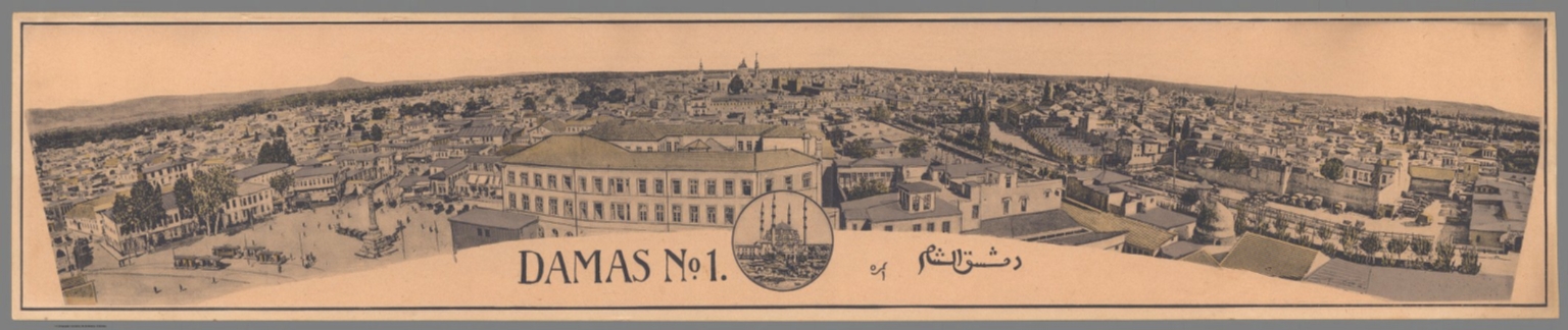
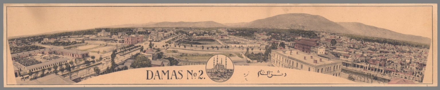
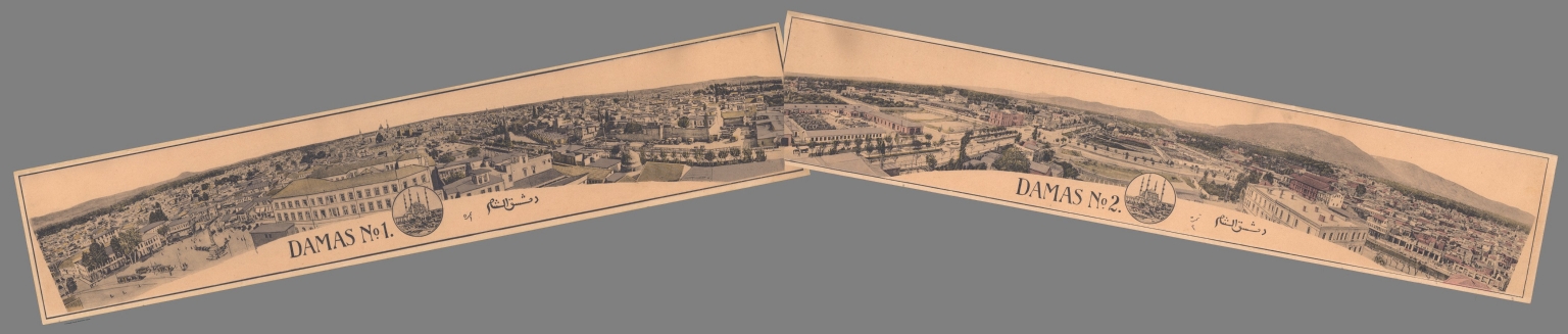


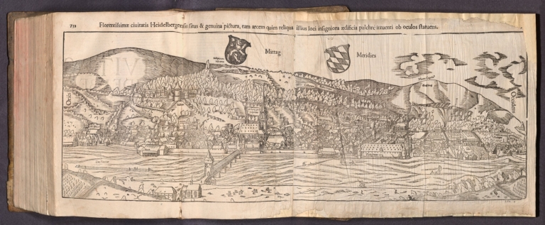

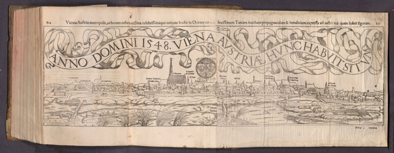


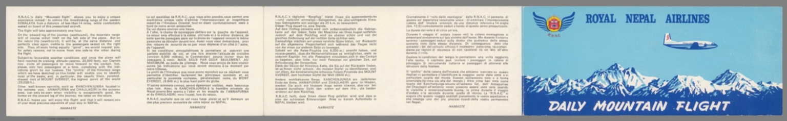
![[The Indeitsev Panorama of Moscow]](https://media.davidrumsey.com/MediaManager/srvr?mediafile=/Size4/RUMSEY~8~1/195/10967000.jpg)


![Text: Chap. I [III]. Of the Canary Islands.](https://www.davidrumsey.com/rumsey/Size2/RUMSEY~8~1/195/14347012.jpg)


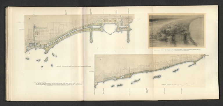


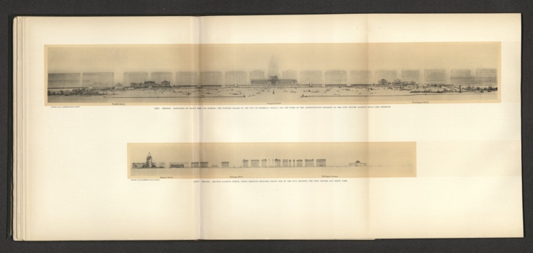


![CXXI [CXXXI]. Chicago : Elevation showing the group of buildings constituting the proposed Civic Center.](https://media.davidrumsey.com/MediaManager/srvr?mediafile=/Size3/RUMSEY~8~1/195/14346106.jpg)


![[View of seafarers].](https://www.davidrumsey.com/rumsey/Size2/RUMSEY~8~1/195/14351004.jpg)


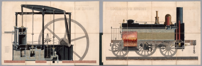


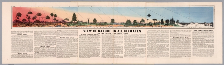


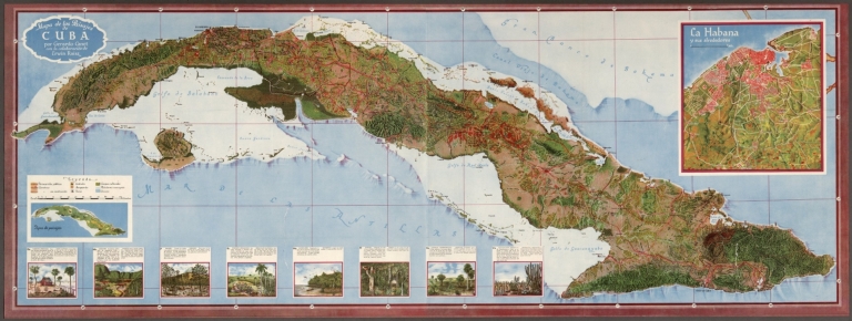

![[Embossed image]. (1)](https://www.davidrumsey.com/rumsey/Size2/RUMSEY~8~1/195/14337005.jpg)
![[Embossed image]. (2)](https://www.davidrumsey.com/rumsey/Size2/RUMSEY~8~1/195/14337006.jpg)
![[Embossed image]. (3)](https://www.davidrumsey.com/rumsey/Size1/RUMSEY~8~1/195/14337008.jpg)
![[Embossed image]. (4)](https://www.davidrumsey.com/rumsey/Size2/RUMSEY~8~1/195/14337009.jpg)
![[Embossed image]. (5)](https://www.davidrumsey.com/rumsey/Size1/RUMSEY~8~1/195/14337011.jpg)
![[Embossed image]. (6)](https://www.davidrumsey.com/rumsey/Size2/RUMSEY~8~1/195/14337012.jpg)
![[Embossed image]. (7)](https://www.davidrumsey.com/rumsey/Size2/RUMSEY~8~1/195/14337014.jpg)
![[Embossed image]. (8)](https://www.davidrumsey.com/rumsey/Size2/RUMSEY~8~1/195/14337016.jpg)
![[Embossed image]. (9)](https://www.davidrumsey.com/rumsey/Size2/RUMSEY~8~1/195/14337017.jpg)


![42. AΠΩΛEIEΣ TOY EMΠOPIKOY NAYTIKOY. [Losses of the merchant marine].](https://www.davidrumsey.com/rumsey/Size1/RUMSEY~8~1/195/14295095.jpg)
![43. ΠOΛITIKH AEPOΠOPIA. [Civil aviation].](https://www.davidrumsey.com/rumsey/Size1/RUMSEY~8~1/195/14295097.jpg)


![El pueblo de Ixtacalco = The vil[l]age of Ixtacalco = Le village d'Ixtacalco.](https://www.davidrumsey.com/rumsey/Size2/RUMSEY~8~1/190/14248050.jpg)


![古嶋松之助. Attack on Pearl Harbor. ハワイ大海戦図. [Hawai daikaisenzu].](https://www.davidrumsey.com/rumsey/Size2/RUMSEY~8~1/190/10806000.jpg)