Ransom, Leander, 1800 - 1874; California... A skeleton map of the State of Californi... 1853 11716.000 Related Author
[Ransom, Leander, 1800 - 1874, California Academy of Natural Sciences.]
Full Title
A skeleton map of the State of California : exhibiting the U.S. township and range lines and boundaries of U.S. land districts, the county seats and the lines of equal variations of the compass. Compiled from authentic sources for the California Academy of Natural Sciences by Leander Ransom. Lithographed and published by B.F. Butler, San Francisco.
List No
11716.000
Note
"The Earliest Commercially Printed Map of California to Show the Baselines and Meridians in California. A remarkable early map of Califiornia, published by Leander Ransom for the California Academy of Natural Sciences and lithographed in San Francisco by B.F. Butler. The map is one of the first maps of the state of California printed in California. We have dated the map at 1853, which is the first year of the Academy. Vodges dates the map as "some time in the fifties." Rowell dates the map as "185-". This is the only map of which we are aware the records the lines of equal variation of the compass, or Magnetic Needle."(Ruderman) Date estimated. Showing county boundaries, townships, and Land Offices. Townships and ranges are numbered. Includes explanation. Leander Ransom was born in Colchester, Connecticut and educated in New York. Came to California in 1851 with Samuel D. King, who was the U. S. Surveyor General for California. They arrived in San Francisco on June 14, 1851. From July 1851 to September 1851, Ransom conducted the first Public Land Survey in California as Deputy Surveyor. The Mount Diablo Principal Meridian and Base Line extending from the Mount Diablo Initial Point, established on July 17, 1851 by Ransom, controls Public Land Surveys within two-thirds of California and all of Nevada. B.F. Butler was one of the earliest lithographers working in San Francisco. Butler was the lithographer for Eddy's map of San Francisco, published in 1851.
Author
U.S. General Land Office
Full Title
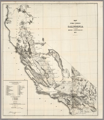
Map of the Public Surveys in California and Nevada to accompany Report of the Commissioner of the General Land Office 1866. Department of the Interior, General Land Office, October 2nd 1866. Jo. S. Wilson, Commissioner. Lith. of J. Bien, 24 Vesey Street, N.Y. House R. Ex. Doc. No. 1. 38th Cong. 1st. Sess.
List No
1070.020
Note
Map in outline color. The following items are shown: asphaltum wells, salt ponds, oil springs, and numerous types of mines including gold, silver, quick silver, copper, tin and lead.
Author
U.S. General Land Office
Full Title
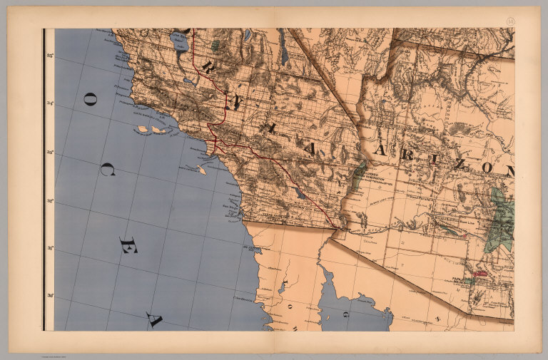
(Map 14 - California, Arizona, Nevada).
List No
1071.016
Note
One of the series of adjacent sixteen maps. Mounted on linen. Relief shown in hachures.
Author
U.S. General Land Office
Full Title
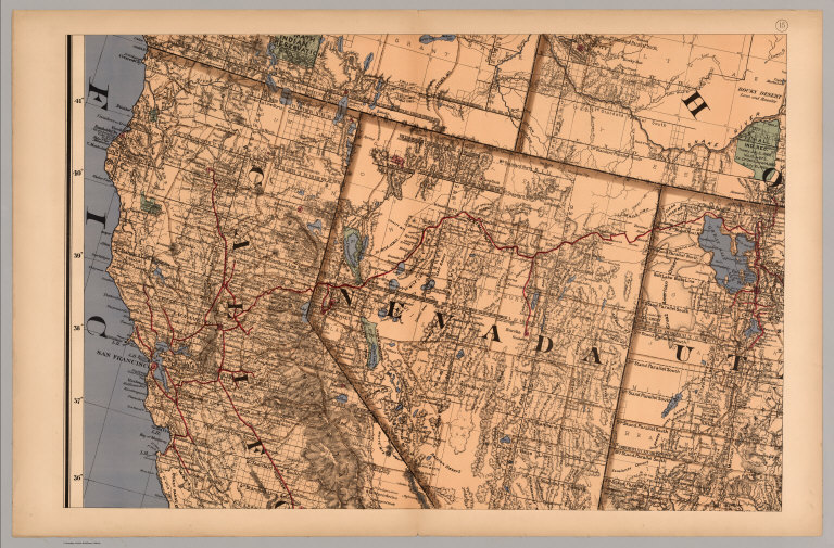
(Map 15 - California, Nevada, Utah, Idaho).
List No
1071.017
Note
One of the series of adjacent sixteen maps. Mounted on linen. Relief shown in hachures.
Author
U.S. General Land Office
Full Title
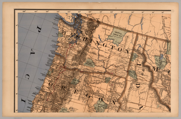
(Map 16 - Washington, Oregon, Montana, Idaho).
List No
1071.018
Note
One of the series of adjacent sixteen maps. Mounted on linen. Relief shown in hachures.
Author
U.S. General Land Office
Full Title
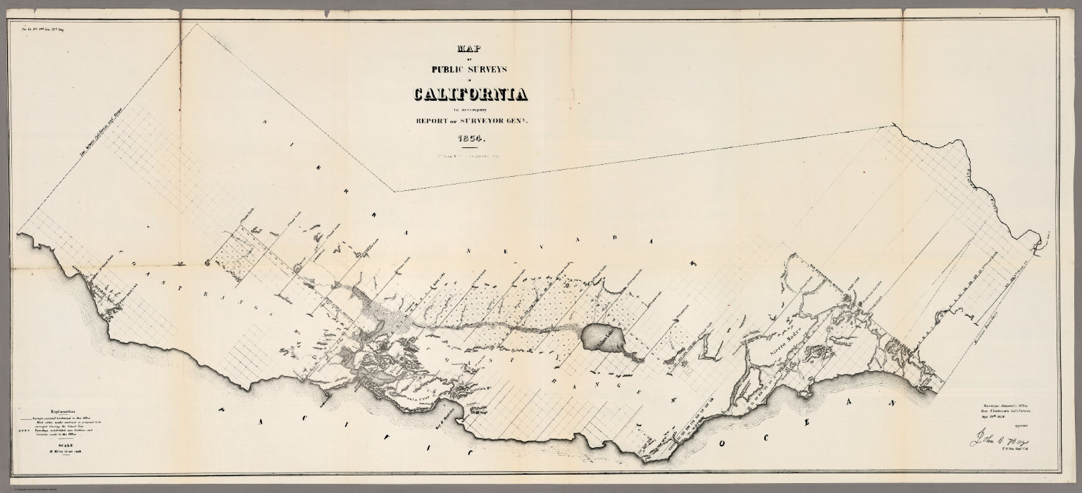
Map of the Public Surveys in California ; to Accompany Report of Surveyor Genl., 1854. P.S. Duval & Co's Steam Lith. Press. Phila. Surveyor General's Office, San Francisco, Calif., Sept. 28th, 1854, Approved John C. Hays, U.S. Sur. Genl. Cal.
List No
1073.001
Note
Eleven issues from the Annual Report, (1854,55,56,57,58,59,60,61,62, 63,64). Without color. Scale 16 miles to an inch. Relief shown by hachures. In upper left corner: Sen. Ex. No. 1. 2nd Sess. 33d Cong. Shows townships, and lands surveyed and proposed to be surveyed. Includes Explanation.
Author
U.S. General Land Office
Full Title
Map of the Public Surveys in California ; to Accompany Report of Surveyor Genl., 1855. Lith. by A. Hoen & Co. Balto. Surveyor General's Office, San Francisco, Calif., Sept. 30th, 1855, Approved John C. Hays, U.S. Sur. Genl. Cal.
List No
1073.002
Note
Eleven issues from the Annual Report, (1854,55,56,57,58,59,60,61,62, 63,64). Without color. Scale 18 miles to an inch. Relief shown by hachures. In upper right corner: Sen. Ex. Doc. No. 1. , 34th. Cong. 1st. Sess. Shows townships, and lands surveyed and proposed to be surveyed. Includes Explanation. (From: Report of the Commissioner of the General Land Office).
Author
U.S. General Land Office
Full Title
Map of the Public Surveys in California ; to Accompany Report of Surveyor Genl., 1856. Surveyor General's Office, San Francisco, Calif., Sept. 30th, 1856, Approved, U.S. Sur. Genl. Cal.
List No
1073.003
Note
Eleven issues from the Annual Report, (1854,55,56,57,58,59,60,61,62, 63,64). Without color. Scale 18 miles to an inch. Relief shown by hachures. In upper right corner: Senete Exe. Doc. No. 5, 34th Congress, 3rd Session. Shows Description of private Grants, townships, and lands surveyed and proposed to be surveyed. Includes Explanation. (From: Report of the Commissioner of the General Land Office).
Author
U.S. General Land Office
Full Title
Map of the Public Surveys in California ; to Accompany Report of Surveyor Genl., 1857. Wagner & McGuigan Lith. Phila. Surveyor Generals' Office, San Francisco, California, September 30th, 1857, Approved J.W. Mandeville, U.S. Surr. Genl. Cala.
List No
1073.004
Note
Eleven issues from the Annual Report, (1854,55,56,57,58,59,60,61,62, 63,64). Without color. Scale 18 miles to an inch. Relief shown by hachures. In upper right corner: Sen. Ex. Doc. No. 11 & Ho. Ex. Doc. No. 2, 1st Sess., 35th Cong. Shows list of private Grants finally surveyed, townships, and lands surveyed and proposed to be surveyed. Includes Explanation. (From: Report of the Commissioner of the General Land Office).
Author
U.S. General Land Office
Full Title
Map of the Public Surveys in California ; to Accompany Report of Surveyor Genl., 1858. Lith. by Siebert & Kogge, Washington Dist. Colba. Surveyor Generals' Office, San Francisco, California, September 18th, 1858. J.W. Mandeville, U.S. Surr. Genl. Cala.
List No
1073.005
Note
Eleven issues from the Annual Report, (1854,55,56,57,58,59,60,61,62, 63,64). Without color. Scale 18 miles to an inch. Relief shown by hachures. In upper right corner: Sen. Ex. Doc. No. 1 & Ho. Ex. Doc. No. 2, 2nd Sess., 35th Cong.Shows list of private Grants finally surveyed, townships, and lands surveyed and proposed to be surveyed. Includes Explanation. (From: Report of the Commissioner of the General Land Office).
Author
U.S. General Land Office
Full Title
Map of the Public Surveys in California ; to Accompany Report of Surveyor Genl., 1859. Lith. of J. Bien, 180 Broadway, N.Y. Surveyor Generals' Office, San Francisco, California, September 19th, 1859. J.W. Mandeville, U.S. Surr. Genl. Cala.
List No
1073.006
Note
Eleven issues from the Annual Report, (1854,55,56,57,58,59,60,61,62, 63,64). Without color. Scale 18 miles to an inch. Relief shown by hachures. In upper right corner: Sen. Ex. Doc. No. 2, 1st. Sess., 36th Cong. Shows list of private Grants finally surveyed, townships, and lands surveyed and proposed to be surveyed. Includes Explanation. (From: Report of the Commissioner of the General Land Office).
Author
U.S. General Land Office
Full Title
Map of the Public Surveys in California ; to Accompany Report of Surveyor Genl., 1860. Lith. of J. Bien, 180 Broadway, N.Y. Surveyor Generals' Office, San Francisco, California, September 15th, 1860. J.W. Mandeville, U.S. Surveyor General California.
List No
1073.007
Note
Eleven issues from the Annual Report, (1854,55,56,57,58,59,60,61,62, 63,64). Without color. Scale 18 miles to an inch. Relief shown by hachures. In upper right corner: Sen. Ex. Doc. No. 1, 2d. Sess., 36th Cong. Shows list of private Grants finally surveyed, townships, and Indian Reservations, and lands surveyed and proposed to be surveyed. Includes Explanation. (From: Report of the Commissioner of the General Land Office).
Author
U.S. General Land Office
Full Title
Map of the Public Surveys in California ; to Accompany Report of Surveyor Genl., 1861. Lith. of J. Bien, 180 Broadway, N.Y. Surveyor Generals' Office, San Francisco, California, September 15th, 1861. E.F. Beale, U.S. Survr. Genl. Cal.
List No
1073.008
Note
Eleven issues from the Annual Report, (1854,55,56,57,58,59,60,61,62, 63,64). Without color. Scale 18 miles to an inch. Relief shown by hachures. In upper right corner: Sen. Ex. Doc. No. 1, 2d Sess., 31th [sic] Cong. 7. Shows list of private Grants finally surveyed, townships, and Indian Reservations, and lands surveyed and proposed to be surveyed. Includes Explanation. (From: Report of the Commissioner of the General Land Office).
Author
U.S. General Land Office
Full Title
Map of the Public Surveys in California ; to Accompany Report of Surveyor Genl., 1862. Lith. of J. Bien, 180 Broadway, N.Y. Surveyor General's Office, San Francisco, California, September 15th, 1861. E.F. Beale, U.S. Survr. Genl. Cal.
List No
1073.009
Note
Eleven issues from the Annual Report, (1854,55,56,57,58,59,60,61,62, 63,64). Without color. Scale 18 miles to an inch. Relief shown by hachures. In upper right corner: H. R. Ex. Doc. No. 1, 37th Cong. 3rd. Sess. Shows list of private Grants finally surveyed, townships, and Indian Reservations, and lands surveyed and proposed to be surveyed. Includes Explanation. (From: Report of the Commissioner of the General Land Office).
Author
U.S. General Land Office
Full Title
Map of public surveys in California & Nevada : to Accompany Report of Surveyor Genl., 1863. Lith. of J. Bien, N.Y. Surveyor General's Office, San Francisco, California, June 30th, 1863. E.F. Beale, U.S. Survr. Genl. Cal.
List No
1073.010
Note
Eleven issues from the Annual Report, (1854,55,56,57,58,59,60,61,62, 63,64). Without color. Scale 18 miles to an inch. Covers only western portion of Nevada. Relief shown by hachures. In upper right corner:House R. Ex. Doc. No. 1, 38th Cong., 1st Sess. Shows list of private Grants finally surveyed, townships, and Indian Reservations, and lands surveyed and proposed to be surveyed. Includes Explanation. (From: Report of the Commissioner of the General Land Office).
Author
U.S. General Land Office
Full Title
Map of public surveys in California & Nevada : to Accompany Report of Surveyor Genl., 1863 (1864). Lith. of J. Bien, N.Y. Surveyor General's Office, San Francisco, California, June 30th, 1863. E.F. Beale, U.S. Survr. Genl. Cal.
List No
1073.011
Note
Eleven issues from the Annual Report, (1854,55,56,57,58,59,60,61,62, 63,64). Surveyor Genls Office, Land Offices, Land Grant Railroad represented in color. Scale 18 miles to an inch. Covers only western portion of Nevada. Relief shown by hachures. In upper right corner:39th Congress, 1st. Sess. Annual Report Comr., Gen. Land Office. Shows list of private Grants finally surveyed, townships, and Indian Reservations, and lands surveyed and proposed to be surveyed. Includes Explanation. (From: Report of the Commissioner of the General Land Office).
Author
Thompson, Thos. H.
Full Title
Map of the state of California, compiled expressly for Thos. H. Thompson, publisher, Tulare, Cal. Issued with the Tulare County atlas. Lith. Britton & Rey, S.F. (1892)
List No
2211.001
Note
Col. lithograph. Relief shown by hachures. Shows counties, townships, railroads, etc. Includes inset.
Author
Thompson, Thos. H.
Full Title
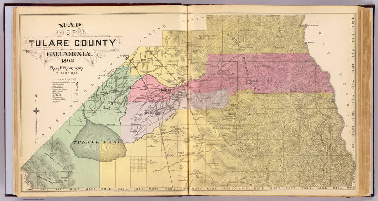
Map of Tulare County, California. 1892. Thos. H. Thompson, Tulare, Cal.
List No
2211.003
Note
Hand col. lithograph. Relief shown by hachures. Shows townships and sections, Indian reservation, Sequoia National Park, schools, railroad, Tulare Lake, etc. In 1893 Kings County was formed from a part of Tulare County.
Full Title
Township 15 South, Range 25 East, Tulare Co., California. (Compiled, drawn and published by Thos. H. Thompson, Tulare, Cal., 1892)
List No
2211.005
Note
Lithograph. Relief shown by hachures. Shows sections and subdivisions, owners, etc.
Full Title
Township 15 South, Range 26 East, Tulare Co., California. (Compiled, drawn and published by Thos. H. Thompson, Tulare, Cal., 1892)
List No
2211.006
Note
Lithograph. Relief shown by hachures. Shows sections and subdivisions, owners, etc.
Full Title
Township 15 South, Range 27 East, Tulare Co., California. (Compiled, drawn and published by Thos. H. Thompson, Tulare, Cal., 1892)
List No
2211.008
Note
Lithograph. Relief shown by hachures. Shows sections and subdivisions, owners, etc. Covers Badger-Bear Mountain area.
Full Title
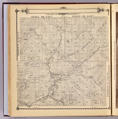
Township 15 South, Township 14 South, Range 28 East, Range 29 East, Tulare Co., California. (Compiled, drawn and published by Thos. H. Thompson, Tulare, Cal., 1892)
List No
2211.009
Note
Lithograph. Relief shown by hachures. Shows sections and subdivisions, owners, etc. Covers parts of Kings Canyon and Sequoia national parks and Sequoia National Forest.
Full Title
Township 15 South, Township 14 South, Range 30 East, Range 31 East, Tulare Co., California. (Compiled, drawn and published by Thos. H. Thompson, Tulare, Cal., 1892)
List No
2211.011
Note
Lithograph. Relief shown by hachures. Shows sections and subdivisions, owners, etc. Covers parts of Sequoia National Park and Sequoia National Forest in vicinity of Mt. Silliman.
Full Title
Township 17 South ... Township 14 South, Range 32 East ... Range 35 East, Tulare Co., California. (with) Map of Lucerne Colony, Tulare County ... (Compiled, drawn and published by Thos. H. Thompson, Tulare, Cal., 1892)
List No
2211.012
Note
Lithograph. Relief shown by hachures. Shows sections, drainage, etc. Covers Mt. Whitney, Mt. Williamson, Kaweah Peak and vicinity in Sequoia National Park region. Inset map "located on E 1/2 Sec. 31, T.18S, R.22E, and is at scale of 6 in. to the mile (1:10,560).
Full Title
Township 16 South, Range 22 East, Tulare Co., California. (with) Map of Mt. Whitney Colony ... (with) Map of Level Orchard Land Colony ... (with) Map of Mack's Addition to Orosi Colony ... (Compiled, drawn and published by Thos. H. Thompson, Tulare, Cal., 1892)
List No
2211.014
Note
Lithograph. Covers sections 22-27, 34-36 in Kingsburg area. Shows sections and subdivisions, owners, etc. Ancillary maps shown lot numbers, owners, etc. Scales: Mack's addition (1:9,600), Mt. Whitney Colony (1:15,840), Level Orchard Land Colony (1:21,120).
Full Title
Township 16 South, Range 23 East, Tulare Co., California. (Compiled, drawn and published by Thos. H. Thompson, Tulare, Cal., 1892)
List No
2211.015
Note
Lithograph. Relief shown by hachures. Shows sections and subdivisions, owners (including C.W. Clarke), etc. Includes Kingsburgh Colony, Windsor Colony and Level Orchard Land Colony.
Full Title
Township 16 South, Range 24 East, Tulare Co., California. (Compiled, drawn and published by Thos. H. Thompson, Tulare, Cal., 1892)
List No
2211.017
Note
Lithograph. Relief shown by hachures. Shows sections and subdivisions, owners, etc. Includes Dinuba, Monson and Dinuba Colony.
Full Title
Map of the town of Monson, Tulare County. (with) Map of Lindsay, Tulare County. (with) Map of Zumwalt's subdivision ... (with) Map of Galicia Vineyard ... (Compiled, drawn and published by Thos. H. Thompson, Tulare, Cal., 1892)
List No
2211.018
Note
Lithograph. Includes 3 inset maps. Shows block and lot numbers, railroad, etc. Lindsay inset at (1:7,200) scale shows block and lot numbers, etc. Galicia Vineyard at (1:7,200) and Zumwalt's Subdivision at (1:7,920) show lot numbers, owners, etc.
Full Title
Township 16 South, Range 25 East, Tulare Co., California. (Compiled, drawn and published by Thos. H. Thompson, Tulare, Cal., 1892)
List No
2211.020
Note
Lithograph. Relief shown by hachures. Shows sections and subdivisions, owners, etc. Includes Orosi and Orosi Colony.
Full Title
Township 16 South, Range 26 East, Tulare Co., California. (Compiled, drawn and published by Thos. H. Thompson, Tulare, Cal., 1892)
List No
2211.021
Note
Lithograph. Relief shown by hachures. Shows sections and subdivisions, owners, etc. Includes Stokes, Wilcox, Grapevine and Dry Creek valleys and Stone Corral Canon.
Full Title
Township 16 South, Range 27 East, Tulare Co., California. (Compiled, drawn and published by Thos. H. Thompson, Tulare, Cal., 1892)
List No
2211.023
Note
Lithograph. Relief shown by hachures. Shows sections and subdivisions, owners, etc. Includes Ash Spring Pass, Allen's Flat and Limekiln Valley.
Full Title
Township 16 South, Township 17 South, Range 28 East, Range 29 East, Tulare Co., California. (Compiled, drawn and published by Thos. H. Thompson, Tulare, Cal., 1892)
List No
2211.024
Note
Lithograph. Relief shown by hachures. Shows sections and subdivisions, owners, etc. Covers Lake Kaweah, Kaweah, Three Rivers and vicinity and part of Sequoia National Park.
Full Title
Township 16 South, Township 17 South, Range 30 East, Range 31 East, Tulare Co., California. (Compiled, drawn and published by Thos. H. Thompson, Tulare, Cal., 1892)
List No
2211.026
Note
Lithograph. Relief shown by hachures. Shows sections and subdivisions, owners, etc. Covers Silver City, Mineral King, and Last Chance and Redwood meadows areas of Sequoia National Park.
Full Title
Township 17 South, Range 21 East, Tulare Co., California. (with) Map of Vina Colony ... (with) Map of Oakview Colony ... (with) Map of Holliday Addition ... (with) Map of Sciarone Subdivision ... (all) Tulare County. (Compiled, drawn and published by Thos. H. Thompson, Tulare, Cal., 1892)
List No
2211.027
Note
Lithograph. Shows sections and subdivisions, owners, etc. Covers Kingston-Laton area in Fresno and Kings counties. Insets at (1:7,920 and 1:15,840) scale.
Full Title
Township 17 South, Range 22 East, Tulare Co., California. (Compiled, drawn and published by Thos. H. Thompson, Tulare, Cal. 1892)
List No
2211.029
Note
Lithograph. Shows sections and subdivisions, owners, etc. Covers Rancho Laguna de Tache and Queen Wilhelmina Colony areas in Kings County.
Full Title
Township 17 South, Range 23 East, Tulare Co., California. (Compiled, drawn and published by Thos. H. Thompson, Tulare, Cal. 1892)
List No
2211.030
Note
Lithograph. Shows sections and subdivisions, owners, etc. Covers Traver and McCall's Colony and addition, Vina Colony, Traver Colony, Sciarone Colony, Kitchener Colony, Ramona Colony, Sacramento Colony and Holliday Addition.
Full Title
Map of Traver, Tulare County. (with) Map of Coe Colony, Tulare Co. (with) Map of Kitchener Colony, Tulare County. (with) Map of Traver Colony, Tulare County. (1892)
List No
2211.032
Note
Lithograph. Shows block and lot numbers, railroad, depot, canal, etc. Insets, at (1:7,920 and 1:15,840) scale, show lot numbers, owners, canal, etc.
Full Title
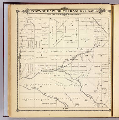
Township 17 South, Range 24 East, Tulare Co., California. (Compiled, drawn and published by Thos. H. Thompson, Tulare, Cal. 1892)
List No
2211.033
Note
Lithograph. Shows sections and subdivisions, owners, etc.
Full Title
Township 17 South, Range 25 East, Tulare Co., California. (Compiled, drawn and published by Thos. H. Thompson, Tulare, Cal. 1892)
List No
2211.035
Note
Lithograph. Shows sections and subdivisions, owners, etc. Includes Taurusa.
Full Title
Township 17 South, Range 26 East, Tulare Co., California. (Compiled, drawn and published by Thos. H. Thompson, Tulare, Cal. 1892)
List No
2211.036
Note
Lithograph. Relief shown by hachures. Shows sections and subdivisions, owners, etc. Includes Colvin Mountain.
Full Title
Township 17 South, Range 27 East, Tulare Co., California. (Compiled, drawn and published by Thos. H. Thompson, Tulare, Cal. 1892)
List No
2211.038
Note
Lithograph. Relief shown by hachures. Shows sections and subdivisions, owners, etc. Includes Antelope Valley and Bravo Lake (Reservoir).
Full Title
Township 18 South, Range 20 East, Tulare Co., California. (with) Map of Dopkins Colony ... (with) Map of Fair View Colony ... (with) Map of Richland Colony ... (all) Tulare County. (Compiled, drawn and published by Thos. H. Thompson, Tulare, Cal. 1892)
List No
2211.039
Note
Lithograph with 3 ancillary maps. Shows sections and subdivisions, owners, etc. Includes Hanford Colony and Fair View Colony and Sterling Colony in Kings County. Insets at (ca. 1:7,920-1:12,000) scale show owners, etc.
Full Title
Township 18 South, Range 21 East, Tulare Co., California. (with) Map of Camp Badger, Tulare County. (Compiled, drawn and published by Thos. H. Thompson, Tulare, Cal. 1892)
List No
2211.041
Note
Lithograph with inset. Shows sections and subdivisions, owners, vineyards, etc. Includes Hanford, Armona and Grangeville. Inset at (1:4,800) scale shows lot numbers.
Full Title
Township 18 South, Range 22 East, Tulare Co., California. (Compiled, drawn and published by Thos. H. Thompson, Tulare, Cal. 1892)
List No
2211.045
Note
Lithograph. Shows sections and subdivisions, owners, etc. Includes Solana Fruit Farm and Lucerne Colony.
Full Title
Township 18 South, Range 23 East, Tulare Co., California. (Compiled, drawn and published by Thos. H. Thompson, Tulare, Cal. 1892)
List No
2211.047
Note
Lithograph. Shows sections and subdivisions, owners, etc. Includes part of Goshen.
Full Title
Township 18 South, Range 24 East, Tulare Co., California. (Compiled, drawn and published by Thos. H. Thompson, Tulare, Cal. 1892)
List No
2211.050
Note
Lithograph. Shows sections and subdivisions, owners, etc. Includes part of Goshen.
Full Title
Township 18 South, Range 25 East, Tulare Co., California. (Compiled, drawn and published by Thos. H. Thompson, Tulare, Cal. 1892)
List No
2211.051
Note
Lithograph. Shows sections and subdivisions, owners, etc. Covers Visalia region.
Full Title
S.E. 1/4 T, 18. S., R.25 E., Tulare Co., California. (Compiled, drawn and published by Thos. H. Thompson, Tulare, Cal. 1892)
List No
2211.053
Note
Lithograph. Shows sections and subdivisions, owners, buildings, etc. Covers Broder Colony, Fleming Fruit Company, etc.
Full Title
S.W. 1/4 T, 18. S., R.25 E., Tulare Co., California. (Compiled, drawn and published by Thos. H. Thompson, Tulare, Cal. 1892)
List No
2211.054
Note
Lithograph. Shows sections and subdivisions, owners, buildings, etc. Covers Visalia, Oakview Colony, Evansdale Fruit Co., etc.
Full Title
Township 18 South, Range 26 East, Tulare Co., California. (Compiled, drawn and published by Thos. H. Thompson, Tulare, Cal. 1892)
List No
2211.056
Note
Lithograph. Relief shown by hachures. Shows sections and subdivisions, owners, etc. Covers Venice Hills, etc.
|