|
Author
Ohashi, Mitsuyoshi
Full Title
(Change of Tokyo city boundary). (to accompany) 東京市勢圖表 = Tōkyo Shisei Zuhyo = Graphic Illustration of Tokyo City. 東京市, Tokyo shi, Showa 10 (1935).
List No
13438.007
Note
4 map on 1 sheet. Showing map showing changes in Tokyo city limits. Includes descriptive text and legend.
Author
Ohashi, Mitsuyoshi
Full Title
(Statistical diagrams). (to accompany) 東京市勢圖表 = Tōkyo Shisei Zuhyo = Graphic Illustration of Tokyo City. 東京市, Tokyo shi, Showa 10 (1935).
List No
13438.008
Note
6 diagrams and graphs on 1 sheet. Includes descriptive text and legend.
Author
Ohashi, Mitsuyoshi
Full Title
(Tokyo City and environs). (to accompany) 東京市勢圖表 = Tōkyo Shisei Zuhyo = Graphic Illustration of Tokyo City. 東京市, Tokyo shi, Showa 10 (1935).
List No
13438.009
Note
Statistical map. Includes descriptive text and legend.
Author
Ohashi, Mitsuyoshi
Full Title
Teito fukko jigyo. (to accompany) 東京市勢圖表 = Tōkyo Shisei Zuhyo = Graphic Illustration of Tokyo City. 東京市, Tokyo shi, Showa 10 (1935).
List No
13438.010
Note
Map showing reconstruction project of Imperial Capital, surrounded by vignettes of various projects and descriptive text.
Author
Ohashi, Mitsuyoshi
Full Title
(World map). (to accompany) 東京市勢圖表 = Tōkyo Shisei Zuhyo = Graphic Illustration of Tokyo City. 東京市, Tokyo shi, Showa 10 (1935).
List No
13438.012
Note
Map showing world populated metropolitan areas. Includes statistical diagram, graphs and descriptive text.
Author
Ohashi, Mitsuyoshi
Full Title
(Population composition by age). (to accompany) 東京市勢圖表 = Tōkyo Shisei Zuhyo = Graphic Illustration of Tokyo City. 東京市, Tokyo shi, Showa 10 (1935).
List No
13438.014
Note
Age structure diagram or population pyramid. Includes graph, color coded key and descriptive text.
Author
Ohashi, Mitsuyoshi
Full Title
(Jobs in education industry). (to accompany) 東京市勢圖表 = Tōkyo Shisei Zuhyo = Graphic Illustration of Tokyo City. 東京市, Tokyo shi, Showa 10 (1935).
List No
13438.018
Note
Map showing Local businesses, educational institutions. Includes color coded key and descriptive text.
Author
Ohashi, Mitsuyoshi
Full Title
(Water industry). (to accompany) 東京市勢圖表 = Tōkyo Shisei Zuhyo = Graphic Illustration of Tokyo City. 東京市, Tokyo shi, Showa 10 (1935).
List No
13438.022
Note
Diagrams, graphs and view, showing circulation of water supply and water distribution in Tokyo. Includes descriptive text.
Author
Ohashi, Mitsuyoshi
Full Title
(Solid waste and polution). (to accompany) 東京市勢圖表 = Tōkyo Shisei Zuhyo = Graphic Illustration of Tokyo City. 東京市, Tokyo shi, Showa 10 (1935).
List No
13438.025
Note
Diagram, graph, and vignettes, showing solid waste, water and air pollution. Includes descriptive text.
Author
Ohashi, Mitsuyoshi
Full Title
(Roads, parks and gardens). (to accompany) 東京市勢圖表 = Tōkyo Shisei Zuhyo = Graphic Illustration of Tokyo City. 東京市, Tokyo shi, Showa 10 (1935).
List No
13438.029
Note
Statistical diagram and graphs showing roads, railway and subway. Includes vignettes, and descriptive text.
Author
Ohashi, Mitsuyoshi
Full Title
(Foreign trade). (to accompany) (to accompany) 東京市勢圖表 = Tōkyo Shisei Zuhyo = Graphic Illustration of Tokyo City. 東京市, Tokyo shi, Showa 10 (1935).
List No
13438.035
Note
Diagrams and graphs, showing foreign exchange and trade system Includes descriptive text.
Author
Ohashi, Mitsuyoshi
Full Title
(Sale and merchandise distributors). (to accompany) (to accompany) 東京市勢圖表 = Tōkyo Shisei Zuhyo = Graphic Illustration of Tokyo City. 東京市, Tokyo shi, Showa 10 (1935).
List No
13438.037
Note
Diagrams and graphs showing wholesale products and distributors. Includes descriptive text.
Author
[Budapest (Hungary). Föváros Statisztikai Hivatal, Illyefalvi, Lajos I., 1881-1944]
Full Title
(Title Page to) Dr. Illyefalvi I. Lajos. A székesföváros jelentösége hazánk anyagi és szellemi müvelödésében. = Dr. Ludwig I. Illyefalvi. Die Bedeutung der Hauptstadt Budapest im Wirtschaftlichen und Geistigen Leben Ungarns.
List No
14247.002
Note
Title page to Budapest székesföváros áruforgalma. Includes German translation of the Hungarian. Verso has text: Felelös szerkesztö: Dr. Illyefalvi Il. Lajos ; Budapest székesföváros házinyomdája 1940 - 1937/8560 ; Felelös nyomdavezetö: Kurfürst István vezérigazgató.
Author
[Budapest (Hungary). Föváros Statisztikai Hivatal, Illyefalvi, Lajos I., 1881-1944]
Full Title
A népesség száma, népsürüség. Népszaporodás. = Anzahl der Bevölkerung. Bevölkerungsdichte. Wachstum der Bevölkerung ...
List No
14247.010
Note
Three colored maps, overlaid with data visualization and accompanied by nine diagrams, representing population - including total numbers, density and growth - in Budapest and greater Hungary, from 1869 to 1930. Includes legends, as well as explanatory text. In both Hungarian and German. Together, maps and diagrams are 23 x 30 cm, on sheet 26 x 35 cm.
Author
[Budapest (Hungary). Föváros Statisztikai Hivatal, Illyefalvi, Lajos I., 1881-1944]
Full Title
A városok és községek népessége. = Bevölkerung der Städte und der Gemeinden.
List No
14247.011
Note
Colored map, overlaid with data visualization, representing the population of cities and municipalities in Budapest and greater Hungary, in 1930. Includes a legend, as well as explanatory text. In both Hungarian and German. With a transparent overlay sheet showing the population statistics of individual cities. Map is 23 x 30 cm, on sheet 26 x 35 cm.
Author
[Budapest (Hungary). Föváros Statisztikai Hivatal, Illyefalvi, Lajos I., 1881-1944]
Full Title
A neme, kora és családi állapota. = Geschlecht, Alter und Familienstand der Bevölkerung ...
List No
14247.012
Note
One colored map, overlaid with data visualization and accompanied by twenty diagrams, representing gender, age and marital status of the population in Budapest and greater Hungary, from 1920 to 1930. Includes legends, as well as explanatory text. In both Hungarian and German. Together, map and diagrams are 23 x 30 cm, on sheet 26 x 35 cm.
Author
[Budapest (Hungary). Föváros Statisztikai Hivatal, Illyefalvi, Lajos I., 1881-1944]
Full Title
A népesség származása és anyanyelve. = Abstammung und Muttersprache der Bevölkerung ...
List No
14247.013
Note
One colored map, overlaid with data visualization and accompanied by eight diagrams, representing geographic origin and mother tongue of the population in Budapest and greater Hungary, in 1930. Includes legends, as well as explanatory text. In both Hungarian and German. Together, map and diagrams are 23 x 30 cm, on sheet 26 x 35 cm.
Author
[Budapest (Hungary). Föváros Statisztikai Hivatal, Illyefalvi, Lajos I., 1881-1944]
Full Title
A népesség honossága és müveltsége. = Staatsangehürigkeit und Bildungsgrad der Bevölkerung ...
List No
14247.015
Note
Three colored maps, overlaid with data visualization and accompanied by seven diagrams, representing citizenship and education level of the population in Budapest and greater Hungary, in 1930. Includes legends, as well as explanatory text. In both Hungarian and German. Together, maps and diagrams are 23 x 30 cm, on sheet 26 x 35 cm.
Author
[Budapest (Hungary). Föváros Statisztikai Hivatal, Illyefalvi, Lajos I., 1881-1944]
Full Title
Az egyes foglalkozási föcsoportok népességének aránya budapesten és a vidéki törvényhatóságokban. = Verhältnis der Bevölkerung der einzelnen Berufshauptgruppen in der Hauptstadt Budapest und in den Munizipien der Provinz ...
List No
14247.017
Note
One colored map, overlaid with data visualization, representing the ratio of the population according to primary occupational groups in Budapest and greater Hungary, in 1930. Includes a legend, as well as explanatory text. In both Hungarian and German. Map is 23 x 30 cm, on sheet 26 x 35 cm.
Author
[Budapest (Hungary). Föváros Statisztikai Hivatal, Illyefalvi, Lajos I., 1881-1944]
Full Title
Az ipar népessége. = Die Bevölkerung in der Industrie ...
List No
14247.018
Note
Four colored maps, overlaid with data visualization and accompanied by seven diagrams, representing the population according to industry in Budapest and greater Hungary, in 1930. Includes legends, as well as explanatory text. In both Hungarian and German. Together, maps and diagrams are 23 x 30 cm, on sheet 26 x 35 cm.
Author
[Budapest (Hungary). Föváros Statisztikai Hivatal, Illyefalvi, Lajos I., 1881-1944]
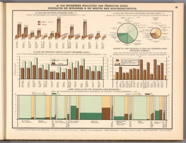
Full Title
Az ipar népességének részletezése ipari föcsoportok szerint. = Spezifikation der Bevölkerung in der Industrie nach Industriehauptgruppen ...
List No
14247.019
Note
Six colored diagrams, representing the specification of the population according to primary industrial groups in Budapest and greater Hungary, in 1930. Includes legends, as well as explanatory text. In both Hungarian and German. Together, diagrams are 23 x 30 cm, on sheet 26 x 35 cm.
Author
[Budapest (Hungary). Föváros Statisztikai Hivatal, Illyefalvi, Lajos I., 1881-1944]
Full Title
A házasulók korviszonyai. = Altersverhältnisse der Eheschliessungen ...
List No
14247.027
Note
Nine colored diagrams, representing marriages - according to age - in the population of Budapest and greater Hungary, from 1929 to 1932. Includes legends, as well as explanatory text. In both Hungarian and German. Together, diagrams are 23 x 30 cm, on sheet 26 x 35 cm.
Author
[Budapest (Hungary). Föváros Statisztikai Hivatal, Illyefalvi, Lajos I., 1881-1944]
Full Title
Halálozások életkor szerint. = Todesfälle nach Alter ...
List No
14247.037
Note
Ten colored diagrams, representing representing mortality - according to age - in the population of Budapest and greater Hungary, from 1901 to 1936. Includes legends, as well as explanatory text. In both Hungarian and German. Together, diagrams are 23 x 30 cm, on sheet 26 x 35 cm.
Author
[Budapest (Hungary). Föváros Statisztikai Hivatal, Illyefalvi, Lajos I., 1881-1944]
Full Title
Halandósági táblázat. (Vége.) = Sterblichkeitstafeln. (Schluss.) (3) ...
List No
14247.040
Note
Four colored diagrams, representing representing mortality in the population of Budapest and greater Hungary, from 1930 to 1931. Third of three pages (28-30). Includes legends, as well as explanatory text. In both Hungarian and German. Together, diagrams are 23 x 30 cm, on sheet 26 x 35 cm.
Author
[Budapest (Hungary). Föváros Statisztikai Hivatal, Illyefalvi, Lajos I., 1881-1944]
Full Title
Lakásviszonyok. = Wohnungsverhältnisse ...
List No
14247.058
Note
Three colored maps, overlaid with data visualization and accompanied by nine diagrams, representing housing conditions in Budapest and greater Hungary, in 1930. Includes legends, as well as explanatory text. In both Hungarian and German. Together, maps and diagrams are 23 x 30 cm, on sheet 26 x 35 cm.
Author
[Budapest (Hungary). Föváros Statisztikai Hivatal, Illyefalvi, Lajos I., 1881-1944]
Full Title
Külkereskedelmi forgalom a fontosabb országokkal. = Aussenhandel mit den Wichtigeren Ländern. (Az egyes országkkal lebonyolított forgalomban érték szerint legjelentékenyebb öt behozatali, ill. kiviteli áru az 1935. Évben. = Die im Verkehr mit den einzelnen Ländern nach dem wert Wichtigsten fünf einfuhr-, bzw. Ausfuhrwaren im Jahre 1935.) (1) ...
List No
14247.108
Note
Four colored maps, overlaid with data visualization, representing the five most significant imports and exports in terms of value in trade with Hungary, by country, in 1935. First of two pages (95-96). Includes legends, as well as explanatory text. In both Hungarian and German. Together, maps are 23 x 30 cm, on sheet 26 x 35 cm.
Author
[Budapest (Hungary). Föváros Statisztikai Hivatal, Illyefalvi, Lajos I., 1881-1944]
Full Title
Vasúthálózat és a fontosabb vasútállomások személyforgalma. = Eisenbahnnetz und Personenverkehr der Wichtigeren Eisenbahnstationen.
List No
14247.118
Note
Colored map, overlaid with data visualization, representing the railway network and passenger traffic of major railway stations in Budapest and greater Hungary, in 1936. Includes legend, as well as explanatory text. In both Hungarian and German. Map is 23 x 30 cm, on sheet 26 x 35 cm.
Author
[Budapest (Hungary). Föváros Statisztikai Hivatal, Illyefalvi, Lajos I., 1881-1944]
Full Title
(Title Page to) Dr. Illyefalvi I. Lajos. Budapest székesföváros áruforgalma. = Dr. Ludwig I. Illyefalvi. Güterverkehr der haupt- und Residenzstadt Budapest.
List No
14246.002
Note
Title page to Budapest székesföváros áruforgalma. Includes German translation of the Hungarian. Verso has text: Felelös szerkesztö: Dr. Illyefalvi Il. Lajos ; Budapest székesföváros házinyomdája 1935 - 11352 ; Felelös nyomdavezetö: Kurfürst István vezérigazgató.
Author
[Budapest (Hungary). Föváros Statisztikai Hivatal, Illyefalvi, Lajos I., 1881-1944]
Full Title
Az áruforgalom alakulása. = Gestaltung der Güterverkehrs ...
List No
14246.014
Note
Twelve colored diagrams representing freight transport in Budapest, from 1874 to 1934. Includes legends, as well as explanatory text. In both Hungarian and German. Together, diagrams are 23 x 30 cm, on sheet 26 x 35 cm.
Author
[Budapest (Hungary). Föváros Statisztikai Hivatal, Illyefalvi, Lajos I., 1881-1944]
Full Title
Az áruforgalom alakulása hónapok szerint. = Gestaltung der Güterverkehrs nach Monaten ...
List No
14246.015
Note
Seven colored diagrams representing freight transport - by month - in Budapest, from 1876 to 1934. Includes legends, as well as explanatory text. In both Hungarian and German. Together, diagrams are 23 x 30 cm, on sheet 26 x 35 cm.
Author
[Budapest (Hungary). Föváros Statisztikai Hivatal, Illyefalvi, Lajos I., 1881-1944]
Full Title
Az áruforgalom megoszlása állomások szerint.¹) = Verteilung des Güterverkehrs nach Stationen.¹) ...
List No
14246.016
Note
Four colored maps representing the distribution of freight transport - according to stations - in districts of Budapest, from 1926 to 1934. Includes a legend, as well as explanatory text. In both Hungarian and German. Together, maps are 23 x 30 cm, on sheet 26 x 35 cm.
Author
[Budapest (Hungary). Föváros Statisztikai Hivatal, Illyefalvi, Lajos I., 1881-1944]
Full Title
Az áruforgalom alakulása termelési ágak szerint. = Gestaltung des Güterverkehrs nach Producktionszweigen ...
List No
14246.017
Note
Four colored diagrams representing freight transport - according to production - in Budapest, from 1926 to 1934. Includes legends, as well as explanatory text. In both Hungarian and German. Together, diagrams are 23 x 30 cm, on sheet 26 x 35 cm.
Author
[Budapest (Hungary). Föváros Statisztikai Hivatal, Illyefalvi, Lajos I., 1881-1944]
Full Title
Az áruforgalom alakulása fontosabb árucsoportok szerint. = Gestaltung des Güterverkehrs nach Wichtigeren Warengruppen. (A statisztikai hivatal régi csoportosítása alapján. = Auf Grund der alten Gruppierung des Statistischen Amtes.) ...
List No
14246.018
Note
Ten colored diagrams representing freight transport - according to primary goods (based on the old classification of the Statistical Office) - in Budapest, from 1874 to 1925. Includes legends. In both Hungarian and German. Together, diagrams are 23 x 30 cm, on sheet 26 x 35 cm.
Author
[Budapest (Hungary). Föváros Statisztikai Hivatal, Illyefalvi, Lajos I., 1881-1944]
Full Title
Az áruforgalom alakulása fontosabb árucsoportok szerint. = Gestaltung des Güterverkehrs nach Wichtigeren Warengruppen. (A statisztikai hivatal új csoportosítása alapján. = Auf Grund der neuen Gruppierung des Statistischen Amtes.) ...
List No
14246.019
Note
Four colored diagrams representing freight transport - according to primary goods (based on the new classification of the Statistical Office) - in Budapest, from 1926 to 1934. Includes legends, as well as explanatory text. In both Hungarian and German. Together, diagrams are 23 x 30 cm, on sheet 26 x 35 cm.
Author
[Budapest (Hungary). Föváros Statisztikai Hivatal, Illyefalvi, Lajos I., 1881-1944]
Full Title
Néhány fontosabb árucikk forgalmának alakulása. = Gestaltung des Verkehrs einiger Wichtigeren Waren ...
List No
14246.020
Note
Twenty colored diagrams representing freight transport - according to primary goods - in Budapest, from 1874 to 1934. Includes legends, as well as explanatory text. In both Hungarian and German. Together, diagrams are 23 x 30 cm, on sheet 26 x 35 cm.
Author
[Budapest (Hungary). Föváros Statisztikai Hivatal, Illyefalvi, Lajos I., 1881-1944]
Full Title
Magyarország községei az árufelhozatalban való részvétel szerint.¹) = Die Gemeinden Ungarns nach ihrer Teilnahme an der Güterzufuhr.¹)
List No
14246.022
Note
Colored map representing the distribution of freight transport - according to stations - in Hungary, in 1933. Includes a legend, as well as explanatory text. In both Hungarian and German. Map is 23 x 30 cm, on sheet 26 x 35 cm.
Author
[Budapest (Hungary). Föváros Statisztikai Hivatal, Illyefalvi, Lajos I., 1881-1944]
Full Title
A felhozatal megoszlása közlekedési eszközök szerint, vármegyénkint.¹) = Verteilung der Zufuhr der einzelnen Komitate nach Verkehrsmitteln.¹)
List No
14246.023
Note
Colored map, overlaid with data visualization and accompanied by a diagram, representing the distribution of the domestic supply of goods within individual counties - according to means of transport - in Hungary, in 1933. Includes a legend, as well as explanatory text. In both Hungarian and German. Together, map and diagrams are 23 x 30 cm, on sheet 26 x 35 cm.
Author
[Budapest (Hungary). Föváros Statisztikai Hivatal, Illyefalvi, Lajos I., 1881-1944]
Full Title
A vasútvonalak belföldi árufelhozatalának intenzitása. = Intensität der Inländischen Güterzufuhr auf den Eisenbahnlinien. 1933.
List No
14246.024
Note
Colored map, overlaid with data visualization, representing the density of the domestic supply of goods along the railway lines of Hungary, in 1933. Includes a legend, as well as explanatory text. In both Hungarian and German. Map is 23 x 30 cm, on sheet 26 x 35 cm.
Author
[Budapest (Hungary). Föváros Statisztikai Hivatal, Illyefalvi, Lajos I., 1881-1944]
Full Title
(Title Page to) Dr. Illyefalvi I. Lajos. A székesföváros múltja és jelene grafikus ábrázolásban. = Dr. Ludwig I. Illyefalvi. Graphische Bilder aus der Vergangenheit und Gegenwart der haupt- und Residenzstadt Budapest.
List No
14245.002
Note
Title page to A székesfőváros múltja és jelene grafikus ábrázolásba. Includes German translation of the Hungarian. Verso has stamp: Bibliotheck d. Ungarischen Instituts an den Univ. Berlin.
Author
[Budapest (Hungary). Föváros Statisztikai Hivatal, Illyefalvi, Lajos I., 1881-1944]
Full Title
Az épületek számának alakulása. = Gestaltung der Anzahl der Gebäude. : A) Általában = Im Allbemeinen. 1720-1930. -- -- B) Kerületek szerint. = Nach Bezirken. 1849-1930. : I. kerület = Bezirk. -- II. kerület = Bezirk. -- III. kerület = Bezirk. -- IV. kerület = Bezirk. -- V. kerület = Bezirk. -- VI. kerület = Bezirk. -- VII. kerület = Bezirk. -- VIII. kerület = Bezirk. -- IX. kerület = Bezirk. -- XI. kerület = Bezirk.
List No
14245.010
Note
Eleven colored diagrams representing changes in buildings in Budapest, over time. Diagram "A" shows the changes in buildings (in general), from 1720 to 1930; diagram "B" shows the changes by district (labeled I through X), from 1849 to 1930. Diagrams include legends. In both Hungarian and German. Together, diagrams are 23 x 30 cm, on sheet 26 x 35 cm.
Author
[Budapest (Hungary). Föváros Statisztikai Hivatal, Illyefalvi, Lajos I., 1881-1944]
Full Title
Az épületek számá városrészek szerint, a lakóházak és egyéb épületek megkülönböztetésével nak alakulása. = Verteilung der Gebäude nach Stadttelien, mit Unterscheidung der Wohnhäuser und Sonstigen Gebäude. 1930.
List No
14245.011
Note
Colored map, overlaid with data visualization, representing the distribution and number of buildings in Budapest, in 1930, comparing dwellings and other buildings. Includes one legend indicating the inner city and outer districts, as well as another illustrating the number of buildings. With a bar scale and scale statement. In both Hungarian and German. Map is 23 x 30 cm, on sheet 26 x 35 cm.
Author
[Budapest (Hungary). Föváros Statisztikai Hivatal, Illyefalvi, Lajos I., 1881-1944]
Full Title
Épületek és lakóházak megoszlása felszerelésük szerint. = Verteilung der Gebäude und Wohnhäuser nach Ausstattung. 1930. -- Épületek és lakóházak megoszlása tetözet és alápincézés szerint. = Verteilung der Gebäude und Wohnhäuser nach Bedachung und Unterkellerung. 1930. -- Épületek vízellátás szerint. = Gebäude nach Wasserversorgung. 1880-1930. -- Épületek tetözet szerint. = Gebäude nach Bedachung. 1880-1930.
List No
14245.016
Note
Four colored diagrams representing distribution of buildings - according to various features - in districts of Budapest, over time. First diagram shows buildings according to equipment, in 1930; second shows roofing and basements, in 1930; third shows water supplies, from 1880 to 1930; and fourth shows roofing, from 1880 to 1930. Diagrams include legends. In both Hungarian and German. Together, diagrams are 23 x 30 cm, on sheet 26 x 35 cm.
Author
[Budapest (Hungary). Föváros Statisztikai Hivatal, Illyefalvi, Lajos I., 1881-1944]
Full Title
Épületek megoszlása felszerelés és alápincézés szerint, városrészenkint. = Verteilung der Gebäude der einzelnen Stadtteile nach Ausstattung und nach Unterkellerung. 1930. : a) Épületek villanyvezetékkel. = Gebäude mit elektrischer Leitung. -- b) Épületek gázvezetékkel. = Gebäude mit Gasleitung. -- c) Épületek vizvezetékkel. = Gebäude mit Wasserleitung. -- d) Alápincézett épületek. = Unterkellerte Gebäude.
List No
14245.017
Note
Four colored maps representing distribution of buildings - according to type of equipment, and basements - in districts of Budapest, in 1930. Map "a" shows buildings with electrical wiring; "b" shows buildings with gas pipelines; "c" shows buildings with plumbing; and "d" shows buildings with basements. Each map includes a legend. In both Hungarian and German. Together, maps are 23 x 30 cm, on sheet 26 x 35 cm.
Author
[Budapest (Hungary). Föváros Statisztikai Hivatal, Illyefalvi, Lajos I., 1881-1944]
Full Title
Épületek megoszlása a bérlemények száma szerint, városrészenkint. = Verteilung der Gebäude der einzelnen Stadtteile nach Anzahl der Mietenheiten. 1930. : a) Épületek 1 bérleménnyel. = Gebäude mit 1 Mieteinheit. -- b) Épületek 2-10 bérleménnyel. = Gebäude mit 2-10 Mieteinheiten. -- c) Épületek 11-50 bérleménnyel. = Gebäude mit 11-50 Mieteinheiten. -- d) Épületek 50-nél több bérleménnyel. = Gebäude mit mehr als 50 Mieteinheiten.
List No
14245.020
Note
Four colored maps representing distribution of buildings - according to the number of renters - in districts of Budapest, in 1930. Map "a" shows buildings with one rental unit; "b" shows buildings with two to ten rental units; "c" shows buildings with eleven to fifty rental units; and "d" shows buildings with more than 50 rental units. Each map includes a legend. In both Hungarian and German. Together, maps are 23 x 30 cm, on sheet 26 x 35 cm.
Author
[Budapest (Hungary). Föváros Statisztikai Hivatal, Illyefalvi, Lajos I., 1881-1944]
Full Title
Épületek megoszlása a szobák száma szerint, városrészenkint. = Verteilung der Gebäude der einzelnen Stadtteile nach Anzahl der Zimmer. 1930. : a) Épületek 1-5 szobával. = Gebäude mit 1-5 Zimmern. -- b) Épületek 6-10 szobával. = Gebäude mit 6-10 Zimmern. -- c) Épületek 11-50 szobával. = Gebäude mit 11-50 Zimmern. -- d) Épületek 50-nél több szobával. = Gebäude mit mehr als 50 Zimmern.
List No
14245.022
Note
Four colored maps representing distribution of buildings - according to the number of rooms - in districts of Budapest, in 1930. Map "a" shows buildings with one to five rooms; "b" shows buildings with six to ten rooms; "c" shows buildings with eleven to fifty rooms; and "d" shows buildings with more than 50 rooms. Each map includes a legend. In both Hungarian and German. Together, maps are 23 x 30 cm, on sheet 26 x 35 cm.
Author
[Budapest (Hungary). Föváros Statisztikai Hivatal, Illyefalvi, Lajos I., 1881-1944]
Full Title
Épületek megoszlása lakottság szerint, városrészenkint. = Verteilung der Gebäude der einzelnen Stadtteile nach der Anzahl der Bewohner. 1930. : a) Épületek 1-10 lakottság. = Gebäude mit 1-10 Bewohnern. -- b) Épületek 11-50 lakottság. = Gebäude mit 11-50 Bewohnern. -- a) Lakók száma az 1-10 lakó által lakott épületekben. = Anzahl der Bewohner in den durch 1-10 Bewohner bewohnten Gebäuden. -- b) Lakók száma az 11-50 lakó által lakott épületekben. = Anzahl der Bewohner in den durch 11-50 Bewohner bewohnten Gebäuden (1).
List No
14245.023
Note
Four colored maps representing distribution of buildings - according to the number of residents - in districts of Budapest, in 1930. Map "a" (brown) shows buildings with one to ten residents; "b" (brown) shows buildings with eleven to fifty residents; "a" (blue) shows number of residents in buildings with one to ten residents; and "b" (blue) shows number of residents in buildings with eleven to fifty residents. First of two pages: both sets continue on next page (16), with maps "c" and "d" in both brown and blue. Each map includes a legend. In both Hungarian and German. Together, maps are 23 x 30 cm, on sheet 26 x 35 cm.
Author
Neurath, Otto, 1882-1945
Full Title
(Title Page to) Gesellschaft und wirtschaft. Bildstatistisches Elementarwerk. Das Gesellschatfs- und Wirtschaftsmuseum in Wien zeigt in 100 farbigen Bildtafeln. Produktionsformen Gesellschaftsordnungen Kulturstufen Lebenshaltungen. Bibliographisches Institut AG. in Leipzig.
List No
14080.002
Note
Title Page to Gesellschaft und wirtschaf, on a loose leaf, beginning set 130-plates in loose-leaf atlas.
Author
Neurath, Otto, 1882-1945
Full Title
(Text Page to) (Copyright 1930 by Bibliographisches Institut AG. in Leipzig. Druck: Bibliographisches Institut AG. in Leipzig).
List No
14080.003
Note
Verso of title page to Gesellschaft und wirtschaf, with copyright statement.
Author
Neurath, Otto, 1882-1945
Full Title
Alte Welt: Staaten und Bevölkerung : Nach 3000 vor Chr. Geb. -- Nach 1500 vor Chr. Geb. -- Nach 500 vor Chr. Geb. Angefertigt für das Bibliographische Institut AG., Leipzig. Gesellschafts- und Wirtschaftsmuseum in Wien. ©
List No
14080.004
Note
Three colored maps, comparing population of countries in the ancient world: 3000 BCE -- 1500 BCE -- 500 BCE. Includes explanatory text. Each map 12 x 23 cm, on sheet 46 x 31 cm. Information depicted with Isotype (International system of typographic picture education), a method for assembling, configuring and disseminating information and statistics through pictorial means, invented by Otto and Marie Neurath.
Author
Neurath, Otto, 1882-1945
Full Title
Alte Welt: Städte : Nach 3000 vor Chr. Geb. -- Nach 1500 vor Chr. Geb. -- Nach 500 vor Chr. Geb. Angefertigt für das Bibliographische Institut AG., Leipzig. Gesellschafts- und Wirtschaftsmuseum in Wien. ©
List No
14080.005
Note
Three colored maps, comparing population of cities in the ancient world: 3000 BCE -- 1500 BCE -- 500 BCE. Includes explanatory text. Each map 12 x 23 cm, on sheet 46 x 31 cm. Information depicted with Isotype (International system of typographic picture education), a method for assembling, configuring and disseminating information and statistics through pictorial means, invented by Otto and Marie Neurath.
|