|
REFINE
Browse All : State Atlas of New Jersey and New York
1-6 of 6
Author
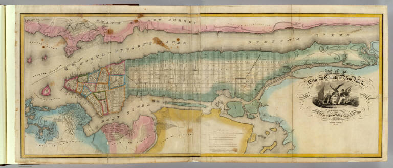
Burr, David H., 1803-1875
Full Title
Map of the City and County of New York with the adjacent country, by David H. Burr, published by Simeon DeWitt, Surveyor General, pursuant to an Act of the Legislature. Second edition 1832.
List No
0103.002
Note
Hand col. engraved map on 2 sheets. Relief shown by hachures. Covers also Jersey City and Horsimus and other communities in N.J. Ornamental cartouche. Includes "Remarks" on streets and distances. David Rumsey Collection copy mounted as 1 sheet.
Author
United States Coast Survey
Full Title
New York Bay and Harbor, New York. From a trigonometrical survey ... Survey of the Coast of the United States. Triangulation by J. Ferguson and E. Blunt, assistants. Topography by H.L. Whiting, S.A. Gilbert, A.M. Harrison, assts., F.W. Dorr, C. Rockwell and J. Mechan sub-assts. Hydrography by the parties under the command of Lieuts. Comdg. R. Wainwright and T.A. Craven, U.S.N. assists. Published in 1866. Edition of 1877. (Philadelphia, Woolman & Rose, 1878)
List No
1234.115
Note
Hand col. lithograph. Relief shown by hachures; soundings in feet and fathoms. Includes tables of light houses and beacons, tides and magnetic declination. Scale (ca. 1:126,720), not "1:80,000" as stated on map. Coast chart no. 20.
Author
[Lloyd, H.H., Warner & Beers]
Full Title
Atlas of the United States, New England, New York, and New Jersey. Warner & Beers, Publishers. From H.H. Lloyd & Co.'s Atlas of the United States.
List No
2585.069
Note
Relief shown in hachures.
Author
[Cook, George Hammell, 1818-1889, Geological Survey of New Jersey, Smock, John Conover, Vermeule, C. C. (Cornelius Clarkson), 1858-1950]
Full Title
A topographical map of the valley of the Passaic with the country eastward to Newark and southward to the Raritan River. George H. Cook, State Geologist, John C. Smock, assistant geologist, C.C.Vermeule, topographer. 1885. Geological Survey of New Jersey. Atlas sheet no. 6, central red sandstone. Julius Bien & Co., Lith. (1888)
List No
2902.008
Note
Col. lithographed map. Relief shown by contours and spot heights. Shows settlements, roads, railroads, mines, quarries, pits, etc. Covers parts of Essex, Middlesex, Morris, Somerset and Union counties plus part of Staten Island. "From original surveys and levelings, supplemented by various local surveys, based on the triangulation of the U.S. Coast and Geodetic Survey."
Author
[Cook, George Hammell, 1818-1889, Geological Survey of New Jersey, Smock, John Conover, Vermeule, C. C. (Cornelius Clarkson), 1858-1950]
Full Title
A topographical map of the counties of Bergen, Hudson and Essex, with parts of Passaic and Union. George H. Cook, State Geologist, John C. Smock, assistant geologist, C.C.Vermeule, topographer. 1884. Geological Survey of New Jersey. Atlas sheet no. 7, northeastern red sandstone. Julius Bien & Co., Lith., N.Y. (1888)
List No
2902.009
Note
Col. lithographed map. Relief shown by contours and spot heights. Shows settlements, roads, railroads, mines, quarries, marshes, meadows, swamps, etc. Covers also Manhattan and Brooklyn. "From original surveys and levelings, supplemented by various local surveys based on the triangulation of the U.S. Coast and Geodetic Survey."
Author
[Cook, George Hammell, 1818-1889, Geological Survey of New Jersey, Vermeule, C. C. (Cornelius Clarkson), 1858-1950]
Full Title
A topographical map of the Monmouth shore with the interior from Metuchen to Lakewood. George H. Cook, State Geologist, C.C.Vermeule, topographer. 1886. Geological Survey of New Jersey. Atlas sheet no. 9, Monmouth shore. Julius Bien & Co., Lith. (1888)
List No
2902.011
Note
Col. lithographed map. Relief shown by contours and spot heights. Shows settlements, roads, railroads, marshes, swamps, cranberry bogs, clay and marl pits, etc. Covers parts of Middlesex and Monmouth counties and Staten Island. "From original surveys and levelings based on the triangulation of the U.S. Coast and Geodetic Survey."
1-6 of 6
|