|
REFINE
Browse All : State Atlas of Berkshire County (Mass.)
1-10 of 10
Author
Geological Survey (U.S.)
Full Title
No. 1. Mass.-Conn.-N.Y. Sheffield sheet. U.S. Geological Survey, J.W. Powell, Director. State of Connecticut ... State of Massachusetts ... commissioners. Henry Gannett, Chief Geographer. Marcus Baker, Geographer in charge. Triangulation by S. Borden and H.F. Walling. Topography by E.W.F. Natter. Surveyed in 1884-1885. (1893)
List No
1084.001
Note
Col. topographic map showing settlements, township boundaries, roads, railroads, streams, buildings, etc. Relief shown by contours and spot heights.
Author
Geological Survey (U.S.)
Full Title
No. 2. Connecticut-Massachusetts, Sandisfield sheet. U.S. Geological Survey, J.W. Powell, Director. State of Connecticut ... State of Massachusetts ... commissioners. Henry Gannett, Chief Geographer. Marcus Baker, Geographer in charge. Triangulation by the U.S. Coast and Geodetic and Borden surveys. Topography by W.H. Lovell, under the direction of Willard D. Johnson, topographer. Surveyed in 1886. (1893)
List No
1084.002
Note
Col. topographic map showing settlements, township boundaries, roads, railroads, streams, buildings, etc. Relief shown by contours and spot heights.
Full Title
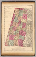
Berkshire County. (H.F. Walling & O.W. Gray, Boston, 1871)
List No
1154.006
Note
Hand col. lithographed map. Relief shown by hachures and spot heights. Shows towns, settlements, school houses, churches, roads, railroads, canals, marshes, etc.
Author
[Geological Survey (U.S.), Massachusetts. Topographical Survey Commission]
Full Title
Massachusetts-New York. Berlin sheet. Preliminary edition subject to corrections. U.S. Geological Survey, J.W. Powell, Director. State of Massachusetts ... commissioners. Henry Gannett, Chief Geographer. Marcus Baker, geographer in charge. Triangulation by the U.S. Coast and Geodetic Survey and C.C. Bassett. Topography by E.W.F. Natter and C.C. Bassett. Surveyed in 1885-88. Forbes Co., Boston & N.Y. (1890)
List No
2883.002
Note
Col. topographic map showing settlements, township boundaries, roads, railroads, streams, buildings, etc. Relief shown by contours and spot heights.
Author
[Geological Survey (U.S.), Massachusetts. Topographical Survey Commission]
Full Title
Massachusetts-New York. Pittsfield sheet. Preliminary edition subject to corrections. U.S. Geological Survey, J.W. Powell, Director. State of Massachusetts ... commissioners. Henry Gannett, Chief Geographer. Marcus Baker, geographer in charge. Triangulation by the U.S. Coast and Geodetic Survey and C.C. Bassett. Topography by by E.W.F. Natter and C.C. Bassett. Surveyed in 1885-8. Forbes Co., Boston & N.Y. (1890)
List No
2883.003
Note
Col. topographic map showing settlements, township boundaries, roads, railroads, streams, buildings, etc. Relief shown by contours and spot heights.
Author
[Geological Survey (U.S.), Massachusetts. Topographical Survey Commission]
Full Title
Massachusetts-Connecticut-New York. Sheffield sheet. Preliminary edition subject to corrections. U.S. Geological Survey, J.W. Powell, Director. State of Massachusetts ... commissioners. Henry Gannett, Chief Geographer. Marcus Baker, geographer in charge. Triangulation by S. Borden and H.F. Walling. Topography by E.W.F. Natter. Surveyed in 1884-5. Forbes Co., Boston & N.Y. (1890)
List No
2883.004
Note
Col. topographic map showing settlements, township boundaries, roads, railroads, streams, buildings, etc. Relief shown by contours and spot heights.
Author
[Geological Survey (U.S.), Massachusetts. Topographical Survey Commission]
Full Title
Massachusetts. Greylock sheet. Preliminary edition subject to corrections. U.S. Geological Survey, J.W. Powell, Director. State of Massachusetts ... commissioners. Henry Gannett, Chief Geographer. Triangulation by the U.S. Coast and Geodetic and Borden surveys. Topography by W.D. Johnson, R.D. Cummin and W.H. Lovell. Surveyed in 1885. Forbes Co., Boston & N.Y. (1890)
List No
2883.005
Note
Col. topographic map showing settlements, township boundaries, roads, railroads, streams, buildings, etc. Relief shown by contours and spot heights.
Author
[Geological Survey (U.S.), Massachusetts. Topographical Survey Commission]
Full Title
Massachusetts. Becket sheet. Preliminary edition subject to corrections. U.S. Geological Survey, J.W. Powell, Director. State of Massachusetts ... commissioners. Henry Gannett, Chief Geographer. Marcus Baker, geographer in charge. Triangulation by the U.S. Coast and Geodetic and Borden surveys. Willard D. Johnson, Topographer in charge. Topography by Robert D. Cummin. Surveyed in 1886. Forbes Co., Boston & N.Y. (1890)
List No
2883.006
Note
Col. topographic map showing settlements, township boundaries, roads, railroads, streams, buildings, etc. Relief shown by contours and spot heights.
Author
[Geological Survey (U.S.), Massachusetts. Topographical Survey Commission]
Full Title
Massachusetts. Sandisfield sheet. Preliminary edition subject to corrections. U.S. Geological Survey, J.W. Powell, Director. State of Massachusetts ... commissioners. Henry Gannett, Chief Geographer. Marcus Baker, geographer in charge. Triangulation by the U.S. Coast and Geodetic and Borden surveys. Topography by W.H. Lovell, under direction of Willard D. Johnson, topographer. Surveyed in 1886. Forbes Co., Boston & N.Y. (1890)
List No
2883.007
Note
Col. topographic map showing settlements, township boundaries, roads, railroads, streams, buildings, etc. Relief shown by contours and spot heights.
Author
[Geological Survey (U.S.), Massachusetts. Topographical Survey Commission]
Full Title
Massachusetts-Vermont. Hawley sheet. Preliminary edition subject to corrections. U.S. Geological Survey, J.W. Powell, Director. State of Massachusetts ... commissioners. Henry Gannett, Chief Geographer. Marcus Baker, geographer in charge. Triangulation by Borden Survey. Topography by H.L. Smyth, W.H. Lovell and G.H. Page under direction of W.D. Johnson. Surveyed in 1886. Forbes Co., Boston & N.Y. (1890)
List No
2883.008
Note
Col. topographic map showing settlements, township boundaries, roads, railroads, streams, buildings, etc. Relief shown by contours and spot heights. Covers parts of Berkshire, Franklin and Hampshire counties, Mass., and Bennington and Windham counties, Vermont.
1-10 of 10
|