|
Author
[Mitchell, Samuel Augustus, Tanner, Henry S.]
Full Title
Massachusetts and Rhode Island: by H.S. Tanner. (with) Boston. Published by S. Augustus Mitchell, N.E. corner of Market & 7th sts., Philada., 1846. Entered ... 1841 by H.S. Tanner ... Pennsylvania.
List No
0536.004
Note
Map printed in color -- outline color by county, in red and blue ink -- rather than the more normal (for this period) hand color. Relief shown by hachures. Shows settlements, roads, canals, railroads, etc. Prime meridian: Washington. Scale of Boston map ca. 1:26,000.
Author
Geological Survey (U.S.)
Full Title
No. 1. Mass.-Conn.-N.Y. Sheffield sheet. U.S. Geological Survey, J.W. Powell, Director. State of Connecticut ... State of Massachusetts ... commissioners. Henry Gannett, Chief Geographer. Marcus Baker, Geographer in charge. Triangulation by S. Borden and H.F. Walling. Topography by E.W.F. Natter. Surveyed in 1884-1885. (1893)
List No
1084.001
Note
Col. topographic map showing settlements, township boundaries, roads, railroads, streams, buildings, etc. Relief shown by contours and spot heights.
Author
Geological Survey (U.S.)
Full Title
No. 2. Connecticut-Massachusetts, Sandisfield sheet. U.S. Geological Survey, J.W. Powell, Director. State of Connecticut ... State of Massachusetts ... commissioners. Henry Gannett, Chief Geographer. Marcus Baker, Geographer in charge. Triangulation by the U.S. Coast and Geodetic and Borden surveys. Topography by W.H. Lovell, under the direction of Willard D. Johnson, topographer. Surveyed in 1886. (1893)
List No
1084.002
Note
Col. topographic map showing settlements, township boundaries, roads, railroads, streams, buildings, etc. Relief shown by contours and spot heights.
Author
Geological Survey (U.S.)
Full Title
No. 3. Mass.-Conn. Granville sheet. U.S. Geological Survey, J.W. Powell, Director. State of Connecticut ... State of Massachusetts ... commissioners. Henry Gannett, Chief Geographer. Marcus Baker, Geographer in charge. Triangulation by the U.S. Coast and Geodetic and Borden surveys. Topography by C.C. Bassett, under the direction of W.D. Johnson, topographer. Surveyed in 1886-7. (1893)
List No
1084.003
Note
Col. topographic map showing settlements, township boundaries, roads, railroads, streams, buildings, etc. Relief shown by contours and spot heights.
Author
Geological Survey (U.S.)
Full Title
No. 4. Massachusetts-Connecticut. Springfield sheet. U.S. Geological Survey, J.W. Powell, Director. State of Connecticut ... State of Massachusetts ... commissioners. Henry Gannett, Chief Geographer. Marcus Baker, Geographer in charge. Triangulation by U.S. Coast and Geodetic Survey and Borden surveys. Topography by C.C. Bassett and C. Arrick, under direction of W.D. Johnson and S.H. Bodfish. Surveyed in 1886 and 1887. (1893)
List No
1084.004
Note
Col. topographic map showing settlements, township boundaries, roads, railroads, streams, buildings, etc. Relief shown by contours and spot heights.
Author
Geological Survey (U.S.)
Full Title
No. 5. Mass.-Conn. Palmer sheet. U.S. Geological Survey, J.W. Powell, Director. State of Connecticut ... State of Massachusetts ... commissioners. Henry Gannett, Chief Geographer. Marcus Baker, Geographer in charge. Triangulation by the U.S. Coast and Geodetic Survey. Topography by C. Arrick, D.J. Howell, W. Kramer and R. Robertson under the direction of S.H. Bodfish and E.W.F. Natter. Surveyed in 1886-7. (1893)
List No
1084.005
Note
Col. topographic map showing settlements, township boundaries, roads, railroads, streams, buildings, etc. Relief shown by contours and spot heights.
Author
Geological Survey (U.S.)
Full Title
No. 6. Massachusetts-Connecticut. Brookfield sheet. U.S. Geological Survey, J.W. Powell, Director. State of Connecticut ... State of Massachusetts ... commissioners. Henry Gannett, Chief Geographer. Marcus Baker, Geographer in charge. Triangulation by the U.S. Coast and Geodetic and Borden surveys. Topography by E.W.F. Natter and W.J. Grambs. Surveyed in 1886-7. (1893)
List No
1084.006
Note
Col. topographic map showing settlements, township boundaries, roads, railroads, streams, buildings, etc. Relief shown by contours and spot heights.
Author
Geological Survey (U.S.)
Full Title
No. 7. Mass.-Conn.-R.I. Webster sheet. U.S. Geological Survey, J.W. Powell, Director. State of Connecticut ... State of Massachusetts ... commissioners. Henry Gannett, Chief Geographer. Marcus Baker, Geographer in charge. Triangulation by the U.S. Coast and Geodetic and Borden surveys. Topography by C.C. Bassett and R.H. Phillips under direction of W.D. Johnson, topographer. Surveyed in 1886-7. (1893)
List No
1084.007
Note
Col. topographic map showing settlements, township boundaries, roads, railroads, streams, buildings, etc. Relief shown by contours and spot heights.
Author
[Gray, Ormando Willis, Hitchcock, Charles H. (Charles Henry), 1836-1919, Walling, H. F.]
Full Title
Geological map of Massachusetts, compiled by C.H. Hitchcock, Ph.D., professor of geology in Dartmouth College. H.F. Walling & O.W. Gray, Boston, 1871.
List No
1154.001
Note
Hand col. lithographed map. Shows 24 geologic units plus deposits or beds of marl, iron, lead, copper, manganese and zinc. Includes text and drawing of Paradoxides harlani (fig. 1.).
Author
[Blodget, Lorin, Gray, Ormando Willis, Walling, H. F.]
Full Title
Climatological map of Massachusetts showing the average temperature, amount of rain fall &c. by Lorin Blodgett (i.e. Blodget. H.F. Walling & O.W. Gray, Boston, 1871)
List No
1154.002
Note
Lithographed map. Includes text: The climate of Massachusetts by Lorin Blodget ...
Author
[Gray, Ormando Willis, Walling, H. F.]
Full Title
Map of Massachusetts comprising counties, towns, villages, railroads, stations, etc. H.F. Walling & O.W. Gray, Boston, 1871.
List No
1154.005
Note
Hand col. lithographed map. Includes table of "Railways of Massachusetts" and "Boston & vic. railway stations." "Entered according to Act of Congress in the year 1870 by Walling & Gray in the Office of the Librarian of Congress."
Full Title
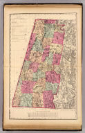
Berkshire County. (H.F. Walling & O.W. Gray, Boston, 1871)
List No
1154.006
Note
Hand col. lithographed map. Relief shown by hachures and spot heights. Shows towns, settlements, school houses, churches, roads, railroads, canals, marshes, etc.
Full Title
Franklin County. (H.F. Walling & O.W. Gray, Boston, 1871)
List No
1154.007
Note
Hand col. lithographed map. Relief shown by hachures. Shows towns, settlements, school houses, churches, roads, railroads, canals, marshes, etc.
Full Title
Hampshire County, Hampden County. (H.F. Walling & O.W. Gray, Boston, 1871)
List No
1154.008
Note
Hand col. lithographed map. Relief shown by hachures and spot heights. Shows towns, settlements, school houses, churches, roads, railroads, canals, marshes, etc.
Full Title
Worcester County. (H.F. Walling & O.W. Gray, Boston, 1871)
List No
1154.009
Note
Hand col. lithographed map. Relief shown by hachures and spot heights. Shows towns, settlements, school houses, churches, roads, railroads, etc.
Full Title
Middlesex County. (H.F. Walling & O.W. Gray, Boston, 1871)
List No
1154.010
Note
Hand col. lithographed map. Relief shown by hachures and spot heights. Shows towns, settlements, school houses, churches, roads, railroads, marshes, etc.
Full Title
Essex County. Norfolk County. (H.F. Walling & O.W. Gray, Boston, 1871)
List No
1154.011
Note
Two hand col. lithographed maps on 1 sheet. Relief shown by hachures. Shows towns, settlements, school houses, churches, roads, railroads, marshes, etc.
Full Title
Bristol County. (H.F. Walling & O.W. Gray, Boston, 1871)
List No
1154.012
Note
Hand col. lithographed map. Relief shown by hachures and spot heights. Shows towns, settlements, school houses, churches, roads, railroads, marshes, etc.
Full Title
Plymouth County. (H.F. Walling & O.W. Gray, Boston, 1871)
List No
1154.013
Note
Hand col. lithographed map. Relief shown by hachures and spot heights. Shows towns, settlements, school houses, churches, roads, railroads, marshes, etc.
Full Title
Barnstable County. (with) Dukes (County). (with) Nantucket. (H.F. Walling & O.W. Gray, Boston, 1871)
List No
1154.014
Note
Hand col. lithographed map. Relief shown by hachures. Shows towns, settlements, school houses, churches, roads, railroads, marshes, etc.
Author
[Gray, Ormando Willis, Walling, H. F.]
Full Title
Map of the compact portions of Boston and the adjacent cities and towns. H.F. Walling & O.W. Gray, Boston, 1871.
List No
1154.015
Note
Hand col. lithographed map. Shows wards, streets, railroads, major buildings, bridges, ferries, etc. Inset: Map showing the present limits of the city of Boston, 1871.
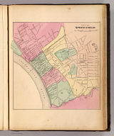
Full Title
City of Springfield. (H.F. Walling & O.W. Gray, Boston, 1871)
List No
1154.016
Note
Hand col. lithographed map. Shows wards, streets, railroads, major buildings, bridges, etc.
Full Title
City of Worcester. (H.F. Walling & O.W. Gray, Boston, 1871)
List No
1154.017
Note
Hand col. lithographed map. Shows wards, streets, railroads, major buildings, etc.
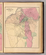
Author
Baker, R. W.
Full Title
City of Lowell. Reduced by permission from the large map by R.W. Baker. (H.F. Walling & O.W. Gray, Boston, 1871)
List No
1154.018
Note
Hand col. lithographed map. Shows wards, streets, railroads, major buildings, commons, cemeteries, bridges, etc.
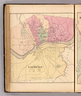
Full Title
City of Lawrence. (H.F. Walling & O.W. Gray, Boston, 1871)
List No
1154.019
Note
Hand col. lithographed map. Shows wards, streets, railroads, major buildings, bridges, dam, commons, cemetery, etc.
Full Title
City of Haverhill. (H.F. Walling & O.W. Gray, Boston, 1871)
List No
1154.020
Note
Hand col. lithographed map. Shows wards, streets, railroads, major buildings, bridges, commons, cemeteries, etc.
Full Title
City of Newburyport. (H.F. Walling & O.W. Gray, Boston, 1871)
List No
1154.021
Note
Hand col. lithographed map. Shows wards, streets, railroads, major buildings, bridges, etc.
Full Title
City of Salem. (H.F. Walling & O.W. Gray, Boston, 1871)
List No
1154.022
Note
Hand col. lithographed map. Shows wards, streets, railroads, major buildings, bridges, cemeteries, etc.
Full Title
City of Lynn. (H.F. Walling & O.W. Gray, Boston, 1871)
List No
1154.023
Note
Hand col. lithographed map. Shows wards, streets, railroad, major buildings, etc.
Full Title
City of Fall River. (H.F. Walling & O.W. Gray, Boston, 1871)
List No
1154.024
Note
Hand col. lithographed map. Shows wards, streets, railroads, major buildings, etc.
Full Title
City of New Bedford. (H.F. Walling & O.W. Gray, Boston, 1871)
List No
1154.025
Note
Hand col. lithographed map. Shows wards, streets, railroads, major buildings, bridges, etc.
Author
[Walker, G.H., Walker, O.W.]
Full Title
Massachusetts. Atlas Plate No. 1.
List No
2006.009
Author
[Walker, G.H., Walker, O.W.]
Full Title
Massachusetts. Atlas Plate No. 2.
List No
2006.012
Author
[Walker, G.H., Walker, O.W.]
Full Title
Massachusetts. Atlas Plate No. 3.
List No
2006.015
Author
[Walker, G.H., Walker, O.W.]
Full Title
Massachusetts. Atlas Plate No. 5.
List No
2006.019
Author
[Walker, G.H., Walker, O.W.]
Full Title
Massachusetts. Atlas Plate No. 6.
List No
2006.032
Author
[Walker, G.H., Walker, O.W.]
Full Title
Massachusetts. Atlas Plate No. 7.
List No
2006.034
Author
[Walker, G.H., Walker, O.W.]
Full Title
Massachusetts. Atlas Plate No. 8.
List No
2006.035
Author
[Walker, G.H., Walker, O.W.]
Full Title
Massachusetts. Atlas Plate No. 9.
List No
2006.036
Author
[Walker, G.H., Walker, O.W.]
Full Title
Massachusetts. Atlas Plate No. 10.
List No
2006.037
Author
[Walker, G.H., Walker, O.W.]
Full Title
Massachusetts. Atlas Plate No. 11.
List No
2006.038
Author
[Walker, G.H., Walker, O.W.]
Full Title
Massachusetts. Atlas Plate No. 12.
List No
2006.039
Author
[Walker, G.H., Walker, O.W.]
Full Title
Massachusetts. Atlas Plate No. 13.
List No
2006.040
Author
[Walker, G.H., Walker, O.W.]
Full Title
Massachusetts. Atlas Plate No. 14.
List No
2006.043
Author
[Walker, G.H., Walker, O.W.]
Full Title
Massachusetts. Atlas Plate No. 15.
List No
2006.045
Author
[Walker, G.H., Walker, O.W.]
Full Title
Massachusetts. Atlas Plate No. 16.
List No
2006.046
Author
[Walker, G.H., Walker, O.W.]
Full Title
Massachusetts. Atlas Plate No. 17.
List No
2006.047
Author
[Walker, G.H., Walker, O.W.]
Full Title
Massachusetts. Atlas Plate No. 18.
List No
2006.049
Author
[Walker, G.H., Walker, O.W.]
Full Title
Massachusetts. Atlas Plate No. 19.
List No
2006.051
Author
[Walker, G.H., Walker, O.W.]
Full Title
Massachusetts. Atlas Plate No. 20.
List No
2006.052
|