|
Author
[Aitken, Robert, Simitiere, Pierre]
Full Title
Map of the Maritime Parts of Virginia Exhibiting the Seat of War and of Ld. Dunmore's depredations in that Colony.
List No
15852.000
Author
[Guyer, Terry, BioSpace]
Full Title
BioCapital
List No
15303.000
Author
[Guyer, Terry, BioSpace]
Full Title
BioCapital
List No
15306.000
Author
Howell, C.W.
Full Title
Map Of The Battle Fields Of The Wilderness May 5th 6th and 7th 1864. Showing the Field of Operations of the Army of the Potomac Commanded by Maj. Gen. George G. Meade U.S.A. Surveyed under the orders of Bvt. Col. J.C. Duane ... By Bvt. Maj. C.W. Howell 1st Lieut. of Engineers. Assisted by Messrs. L.C. Oswell, L. Bell and R.B. Talfor. Topographical Engineers. Instruments Used Schmalcalder Compass Odometer and Tape-Measure, Time 3 days. J. Bien, Lith. 24 Vesey St. N.Y.
List No
3865.002
Note
Date estimated.
Author
[Lea, Philip, Thornton, John, Morden, Robert]
Full Title
A New Map of New England New York New Iarsey Pensilvania Maryland and Virginia
List No
10119.000
Note
"Early and highly important map of the English Colonies in North America, which includes the earliest printed plan of New York Harbor. Thornton, Morden & Lea's map is the first obtainable state of the finest general map of England’s American colonies to date. The map is one of the earliest to include Augustine Herrman’s cartography for Virginia and Maryland. To the North it includes one of the earliest depictions of the Pennsylvania colony (est. 1681), the first printed chart of New York Harbor, and significant additions to the cartography of New England. The map shows the English colonies from Cape Ann in Massachusetts to Cape Henry at the mouth of Chesapeake Bay. The map extends as far north as the tributaries of the Hudson, and in the southwest it shows the Delaware and Susquehannah Rivers and as far west as the tributaries of the Potomac and Rapahannock. Augustyn and Cohen note the importance of the inset:: 'To the ambitious person, the map would have presented an enticing vista: it displays a loose federation of colonies, between and beyond which there appears to be ample unclaimed land. It creates an image of an area comfortingly linked by civilization but still containing much open territory.'The geography of Virginia, Maryland, Pennsylvania and New Jersey derives from the Thornton-Greene Mapp of Virginia Mary-land, New Jarsey, New-York, & New England (ca 1678), whose depiction of the region is in turn based largely on Augustine Herrman’s Virginia and Maryland (1673). The Thornton-Morden-Lea departs from these prototypes, however, in showing the new colony of Pennsylvania and incorporating changes to the course of the Delaware and place names along its banks. New York and southern New England are drawn from the Thornton-Greene map, which in turn draws on John Seller’s Mapp of New England (1676). Here as well, Thornton, Morden and Lea, have departed substantially from the prototypes: Long Island’s barrier beaches are shown for the first time on a printed map and numerous place names are introduced along the Connecticut coast and on Cape Cod; the boundaries between Massachusetts, Plymouth and Connecticut colonies are drawn; and several roads are shown. " (Ruderman)
Author
[Haverty, Helen, Adams, Katherine Payne]
Full Title
The cradle of the Republic. Map makers Helen Haverty & Katherine Adams. (Copyright) Helen Havertey & Katherine Payne Adams. (inset) Colonial Williamsburg.
List No
8405.000
Note
Manuscript hand colored pictorial map, mounted on heavy cardboard. Date estimated. Shows rivers, buildings, landmarks, and agricultural products. Includes noted and dated historical scenes, and figures. Title cartouche in upper center decorated with flags, and compass rose on upper right corner decorated with the State Seal of Virginia. We assume this was intended for eventual publication but we can find no record of a published version. Katherine Payne Adams did produced a published map in 1955 titled "Virginia, 1602-1622 : showing the most remarqueable parts thus named in the Ancient Records."
Author
Smith, John Calvin
Full Title
Map showing the advance of the Union army under the command of Lieut.-Gen. Grant, also, battle-fields, fortifications, etc. in the vicinity of Richmond. Drawn by J. Calvin smith, from official documents. New Yourk, published by J. disturnell. 1864.
List No
8004.000.
Note
In 1864 President Lincoln installed Ulysses S. Grant as Lieutenant General and general in chief of the Union Army Gen. Grant in turn decided to apply pressure from the East, West and Trans-Mississipppi front and in May-June of this year, Grant began to butt head with General Lee in the eastern Virginia. This hand color map identifying the counties, major roads, rivers, and railroads, as well as the placement of the troops for both sides of the conflict. It shows fortifications and radial distances from the city of Richmond. Includes text, showing population of the city of Richmond, and "Note: The fortifications around Richmond are numbered from 7 to 18 including Fort Jackson and Fort Johnson".
Author
[Grant, M. B., Howell, R. H.]
Full Title
Map of the seat of war. Published by T.A. Burke, Morning News Office. Compiled & drawn by M.B. Grant C.E. Lithographed by R.H. Howell, Savannah.
List No
8007.000
Note
Hand color map, with place names in Virginia peninsula. Shows roads, railroads, forts and fortifications. Cover eastern Virginia (mostly Manassas and vicinity) and part of Maryland. Includes table of distances.
Author
[Saville, Allen J., Inc., Windsor Farms Inc.]
Full Title
Windsor Farms, a residential development on the James River at Richmond. Henrico Co., Virginia : made for Windsor Farms Inc. Richmond VA. by Allen J. Saville, Inc. Engineering and Construction. Plan by John Nolen - Town Planner; Philip W. Foster - associate Harvard Sq., Cambridge, Mass. Lith. by A Hoen & Co. Richmond VA.
List No
6898.000
Note
Windsor Farms, a neighborhood of Richmond Virginia, was one of the first planned communities in the United States after the Radburn community in New Jersey. Color map. Shows boundary, easement, and building lines, properties by blocks, lot number, parcel number, ownership of large plots, acreage, and roads. Includes note and legend.
Author
DeSilver, Robert
Full Title
A correct map of Virginia. Philadelphia: Published by Robert De Silver, 1827.
List No
0236.000
Note
Updated from M. Carey's 1818 edition General Atlas. Many changes to the Carey plate in the western part of the state -- changes in the mountains, rivers, counties, and towns. DeSilver's imprint below map. Map has outline color by county. Relief shown by hachures. Prime meridians: Philadelphia and London.
Author
Patterson, Frank E. III
Full Title
A true mapp of the town of Williamsburg :Incorporated, 1722, at one time the capital of the Colony of Virginia. Copyright by William C. Ewing. Frank E. Patterson III - 1940 fecit.
List No
11121.000
Note
Color pictorial map. Showing historical buildings and events, city blocks and streets, with coat of arms, and historical events on lower panel. Includes compass rose, text and index.
Author
Lauk and Company
Full Title
Shenandoah National Park. Copyright 1947, Lauk and Company, Luray, Va. Made in U.S.A. (insets) Bid Meadows. (with) Skyland.
List No
11290.000
Note
Pictorial map. Borders with vignettes of plants, recreational activities, and places of interest. Showing park boundary, roads, trails, and place names. Relief shown pictorially.
Author
Culverwell, Tom
Full Title
Map of the Stony Man Region in the Shenandoah National Park showing Skyline Drive and Man's Pursuits & Pleasures in the Region from the most Ancient Times down to the Present. Drawn by Tom Culverwell. Copyright 1935 by Tom Culverwell.
List No
11795.000
Note
Pictorial map of part of the Stony Man Region in the Shenandoah National Park, with decorative title cartouche and vignettes of plants, recreational activities, and places of interest. Showing park boundary, roads, trails, rivers, mountains and place names. Relief shown pictorially. Includes historical vignettes including: Fort Valley, 1758 Indian Massacre Site, Camp Fechner, Mary's Rock, etc.
Author
[U.S. Coast and Geodetic Survey., Bache, A. D.]
Full Title
Preliminary chart of James River, Virginia from Richmond to City Point, including the Appomattox River from Petersburg to the junction : from a trigonometrical survey under the direction of A.D. Bache, Superintendent of the Survey of the Coast of the United States ; triangulation by J. Farley and W.P. Trowbridge Lieut. U.S. Engs. Assists. ; topography by J. Seib & S.A. Wainwright Sub-Assts. ; hydrography by the party under the command of Lieut. R. Wainwright, U.S.N. Assist. Red'd. drng. by W.T. Martin ; Engd. by W. Langran & App. F.W. Benner.
List No
13079.000
Note
Nautical chart of James river, Virginia. Shows parts of Richmond and Petersburg, Virginia. Depths shown by shading and soundings. Relief shown by hachures. Includes description of bars in the James River and Appomattox River, and notes on soundings and tides. Extensive manuscript additions in black pen showing shore topography and red pen showing battle sites.
Author
[Fry, Joshua, Jefferson, Peter]
Full Title
A map of the most inhabited part of Virginia containing the whole province of Maryland with part of Pensilvania, New Jersey and North Carolina. Drawn by Joshua Fry & Peter Jefferson in 1775. Reprinted 1937 by U.S. Geological Survey. Engraved by S.J. Neele, London. (in upper margin) Virginia (eastern part including West Virginia) at the time of the ratification of the Constitution, from a 1787 and 1775 originals ... Issued by the United States Constitution Sesquicentennial Commission.
List No
13081.013
Note
Map of Virginia, Eastern part. With 2 insets: in lower margin is a small map showing Virginia, "taken from Bull. 817, U.S. Geological Survey, 1930, page 140", and The Fry and Jefferson map in the middle. Relief shown pictorially. Includes a facsimile of a note and signature of Thomas and historical text. Series: "This map is one of a series of similar colored maps, depicting the 13 original states, from New Hampshire to Georgia at the time of the formation of the Constitution ..."
Author
Filson, John
Full Title
This map of Kentucke, drawn from actual observations, is inscribed with the most perfect respect, to the Honorable the Congress of the United States of America, and to His Excellecy. George Washington, late Commander in Chief of their Army ... By John Filson. Reprinted 1937 by U.S. Geological Survey. (in upper margin) Virginia (Western part, i.e. Kentucky) at the time of the Constitution, from 1784 and 1789 maps ... Issued by the United States Constitution Sesquicentennial Commission.
List No
13081.014
Note
Map of Virginia, Western part, Kentucky. With inset in lower margin: New map of the States of Georgia South and North Carolina Virginia and Maryland including the Spanish provinces of West and East Florida from the latest surveys. Relief shown pictorially. Includes a facsimile of a note in upper right and historical text. Series: "This map is one of a series of similar colored maps, depicting the 13 original states, from New Hampshire to Georgia at the time of the formation of the Constitution ..."
Author
Madison, Rev. James
Full Title
A Map Of Virginia (upper left sheet) Formed from Actual Surveys, and the Latest as well as most accurate observations, By James Madison, D.D. President of Wm. & Mary College. Drawn by Wm. Davis. Copy Right Secured. Richmond Published 4th March 1807 By the Proprietors. To The General Assembly Of Virginia, This Map is Respectfully Inscribed, by their Fellow Citizens, James Madison, William Prentis, William Davis, Proprietors. Engraved by Fred. Bossler, Richmd. (inset map) Ohio. (4 sheets of 6; 2 editions).
List No
2557.001
Note
Lacks top & bottom middle sheets. An incomplete copy, with the missing two center sheets supplied in facsimile (from the Clements Library copies of the 1807 issue). Seven sheets in all: the 1807 and 1818 issues of the left top (the "Ohio" sheet) and bottom, and the right bottom, and the 1818 sheet of the right top (view of Richmond - which is colored). These sheets were acquired by a collector along with seven other copies of the view sheet, over fifty copies of the Ohio (top left) sheet, and an unknown number of the bottom left and right sheets. No copies of the center sheets were found with this group. Madison was first cousin of President Madison, was President of William and Mary College and organized the production of this map. William Davis drafted the map and William Prentis supervised the surveying and compiling. A second issue was redrafted by Davis in 1818, after Madison's death. It served as the most authoritative map of Virginia until 1827 (when the Wood/Boye map was published), and was the first comprehensive road map of the state. Includes explanatory remarks, showing State line, county line, towns, roads, and selected buildings. Relief shown by hachures.
Author
Madison, Rev. James
Full Title
A Map Of Virginia (upper center sheet) Formed from Actual Surveys, and the Latest as well as most accurate observations, By James Madison, D.D. President of Wm. & Mary College. Drawn by Wm. Davis. Copy Right Secured. Richmond Published 4th March 1807 By the Proprietors. To The General Assembly Of Virginia, This Map is Respectfully Inscribed, by their Fellow Citizens, James Madison, William Prentis, William Davis, Proprietors. Engraved by Fred. Bossler, Richmd. (inset map) Ohio. (4 sheets of 6; 2 editions).
List No
2557.002
Note
Uncolored Facsimile sheet. Lacks top & bottom middle sheets. An incomplete copy, with the missing two center sheets supplied in facsimile (from the Clements Library copies of the 1807 issue). Seven sheets in all: the 1807 and 1818 issues of the left top (the "Ohio" sheet) and bottom, and the right bottom, and the 1818 sheet of the right top (view of Richmond - which is colored). These sheets were acquired by a collector along with seven other copies of the view sheet, over fifty copies of the Ohio (top left) sheet, and an unknown number of the bottom left and right sheets. No copies of the center sheets were found with this group. Madison was first cousin of President Madison, was President of William and Mary College and organized the production of this map. William Davis drafted the map and William Prentis supervised the surveying and compiling. A second issue was redrafted by Davis in 1818, after Madison's death. It served as the most authoritative map of Virginia until 1827 (when the Wood/Boye map was published), and was the first comprehensive road map of the state. Includes explanatory remarks, showing State line, county line, towns, roads, and selected buildings. Relief shown by hachures.
Author
Madison, Rev. James
Full Title
A Map Of Virginia (upper right sheets) Formed from Actual Surveys, and the Latest as well as most accurate observations, By James Madison, D.D. President of Wm. & Mary College. Drawn by Wm. Davis. Copy Right Secured. Richmond Published 4th March 1807 By the Proprietors. To The General Assembly Of Virginia, This Map is Respectfully Inscribed, by their Fellow Citizens, James Madison, William Prentis, William Davis, Proprietors. Engraved by Fred. Bossler, Richmd. (inset map) Ohio. (inset) View of Richmond, Metropolis of Virginia. (4 sheets of 6; 2 editions).
List No
2557.003
Note
Colored view of Richmond. Lacks top & bottom middle sheets. An incomplete copy, with the missing two center sheets supplied in facsimile (from the Clements Library copies of the 1807 issue). Seven sheets in all: the 1807 and 1818 issues of the left top (the "Ohio" sheet) and bottom, and the right bottom, and the 1818 sheet of the right top (view of Richmond - which is colored). These sheets were acquired by a collector along with seven other copies of the view sheet, over fifty copies of the Ohio (top left) sheet, and an unknown number of the bottom left and right sheets. No copies of the center sheets were found with this group. Madison was first cousin of President Madison, was President of William and Mary College and organized the production of this map. William Davis drafted the map and William Prentis supervised the surveying and compiling. A second issue was redrafted by Davis in 1818, after Madison's death. It served as the most authoritative map of Virginia until 1827 (when the Wood/Boye map was published), and was the first comprehensive road map of the state. Includes explanatory remarks, showing State line, county line, towns, roads, and selected buildings. Relief shown by hachures.
Author
Madison, Rev. James
Full Title
A Map Of Virginia (lower left sheet) Formed from Actual Surveys, and the Latest as well as most accurate observations, By James Madison, D.D. President of Wm. & Mary College. Drawn by Wm. Davis. Copy Right Secured. Richmond Published 4th March 1807 By the Proprietors. To The General Assembly Of Virginia, This Map is Respectfully Inscribed, by their Fellow Citizens, James Madison, William Prentis, William Davis, Proprietors. Engraved by Fred. Bossler, Richmd. (inset map) Ohio. (4 sheets of 6; 2 editions).
List No
2557.004
Note
Lacks top & bottom middle sheets. An incomplete copy, with the missing two center sheets supplied in facsimile (from the Clements Library copies of the 1807 issue). Seven sheets in all: the 1807 and 1818 issues of the left top (the "Ohio" sheet) and bottom, and the right bottom, and the 1818 sheet of the right top (view of Richmond - which is colored). These sheets were acquired by a collector along with seven other copies of the view sheet, over fifty copies of the Ohio (top left) sheet, and an unknown number of the bottom left and right sheets. No copies of the center sheets were found with this group. Madison was first cousin of President Madison, was President of William and Mary College and organized the production of this map. William Davis drafted the map and William Prentis supervised the surveying and compiling. A second issue was redrafted by Davis in 1818, after Madison's death. It served as the most authoritative map of Virginia until 1827 (when the Wood/Boye map was published), and was the first comprehensive road map of the state. Includes explanatory remarks, showing State line, county line, towns, roads, and selected buildings. Relief shown by hachures.
Author
Madison, Rev. James
Full Title
A Map Of Virginia (lower center sheet) Formed from Actual Surveys, and the Latest as well as most accurate observations, By James Madison, D.D. President of Wm. & Mary College. Drawn by Wm. Davis. Copy Right Secured. Richmond Published 4th March 1807 By the Proprietors. To The General Assembly Of Virginia, This Map is Respectfully Inscribed, by their Fellow Citizens, James Madison, William Prentis, William Davis, Proprietors. Engraved by Fred. Bossler, Richmd. (inset map) Ohio. (4 sheets of 6; 2 editions).
List No
2557.005
Note
Uncolored facsimile sheet. Lacks top & bottom middle sheets. An incomplete copy, with the missing two center sheets supplied in facsimile (from the Clements Library copies of the 1807 issue). Seven sheets in all: the 1807 and 1818 issues of the left top (the "Ohio" sheet) and bottom, and the right bottom, and the 1818 sheet of the right top (view of Richmond - which is colored). These sheets were acquired by a collector along with seven other copies of the view sheet, over fifty copies of the Ohio (top left) sheet, and an unknown number of the bottom left and right sheets. No copies of the center sheets were found with this group. Madison was first cousin of President Madison, was President of William and Mary College and organized the production of this map. William Davis drafted the map and William Prentis supervised the surveying and compiling. A second issue was redrafted by Davis in 1818, after Madison's death. It served as the most authoritative map of Virginia until 1827 (when the Wood/Boye map was published), and was the first comprehensive road map of the state. Includes explanatory remarks, showing State line, county line, towns, roads, and selected buildings. Relief shown by hachures.
Author
Madison, Rev. James
Full Title
A Map Of Virginia (lower right sheet) Formed from Actual Surveys, and the Latest as well as most accurate observations, By James Madison, D.D. President of Wm. & Mary College. Drawn by Wm. Davis. Copy Right Secured. Richmond Published 4th March 1807 By the Proprietors. To The General Assembly Of Virginia, This Map is Respectfully Inscribed, by their Fellow Citizens, James Madison, William Prentis, William Davis, Proprietors. Engraved by Fred. Bossler, Richmd. (inset map) Ohio. (4 sheets of 6; 2 editions).
List No
2557.006
Note
Lacks top & bottom middle sheets. An incomplete copy, with the missing two center sheets supplied in facsimile (from the Clements Library copies of the 1807 issue). Seven sheets in all: the 1807 and 1818 issues of the left top (the "Ohio" sheet) and bottom, and the right bottom, and the 1818 sheet of the right top (view of Richmond - which is colored). These sheets were acquired by a collector along with seven other copies of the view sheet, over fifty copies of the Ohio (top left) sheet, and an unknown number of the bottom left and right sheets. No copies of the center sheets were found with this group. Madison was first cousin of President Madison, was President of William and Mary College and organized the production of this map. William Davis drafted the map and William Prentis supervised the surveying and compiling. A second issue was redrafted by Davis in 1818, after Madison's death. It served as the most authoritative map of Virginia until 1827 (when the Wood/Boye map was published), and was the first comprehensive road map of the state. Includes explanatory remarks, showing State line, county line, towns, roads, and selected buildings. Relief shown by hachures.
Author
Madison, Rev. James
Full Title
A Map Of Virginia (upper left sheet) Formed from Actual Surveys, and the Latest as well as most accurate observations, By James Madison, D.D. President of Wm. & Mary College. Drawn by Wm. Davis. Copy Right Secured. Richmond Published 4th March 1807 By the Proprietors. To The General Assembly Of Virginia, This Map is Respectfully Inscribed, by their Fellow Citizens, James Madison, William Prentis, William Davis, Proprietors. Engraved by Fred. Bossler, Richmd. (inset map) Ohio. (4 sheets of 6; 2 editions).
List No
2557.007
Note
Lacks top & bottom middle sheets. An incomplete copy, with the missing two center sheets supplied in facsimile (from the Clements Library copies of the 1807 issue). Seven sheets in all: the 1807 and 1818 issues of the left top (the "Ohio" sheet) and bottom, and the right bottom, and the 1818 sheet of the right top (view of Richmond - which is colored). These sheets were acquired by a collector along with seven other copies of the view sheet, over fifty copies of the Ohio (top left) sheet, and an unknown number of the bottom left and right sheets. No copies of the center sheets were found with this group. Madison was first cousin of President Madison, was President of William and Mary College and organized the production of this map. William Davis drafted the map and William Prentis supervised the surveying and compiling. A second issue was redrafted by Davis in 1818, after Madison's death. It served as the most authoritative map of Virginia until 1827 (when the Wood/Boye map was published), and was the first comprehensive road map of the state. Includes explanatory remarks, showing State line, county line, towns, roads, and selected buildings. Relief shown by hachures.
Author
Madison, Rev. James
Full Title
A Map Of Virginia (lower left sheet)Formed from Actual Surveys, and the Latest as well as most accurate observations, By James Madison, D.D. President of Wm. & Mary College. Drawn by Wm. Davis. Copy Right Secured. Richmond Published 4th March 1807 By the Proprietors. To The General Assembly Of Virginia, This Map is Respectfully Inscribed, by their Fellow Citizens, James Madison, William Prentis, William Davis, Proprietors. Engraved by Fred. Bossler, Richmd. (inset map) Ohio. (4 sheets of 6; 2 editions).
List No
2557.008
Note
Lacks top & bottom middle sheets. An incomplete copy, with the missing two center sheets supplied in facsimile (from the Clements Library copies of the 1807 issue). Seven sheets in all: the 1807 and 1818 issues of the left top (the "Ohio" sheet) and bottom, and the right bottom, and the 1818 sheet of the right top (view of Richmond - which is colored). These sheets were acquired by a collector along with seven other copies of the view sheet, over fifty copies of the Ohio (top left) sheet, and an unknown number of the bottom left and right sheets. No copies of the center sheets were found with this group. Madison was first cousin of President Madison, was President of William and Mary College and organized the production of this map. William Davis drafted the map and William Prentis supervised the surveying and compiling. A second issue was redrafted by Davis in 1818, after Madison's death. It served as the most authoritative map of Virginia until 1827 (when the Wood/Boye map was published), and was the first comprehensive road map of the state. Includes explanatory remarks, showing State line, county line, towns, roads, and selected buildings. Relief shown by hachures.
Author
Madison, Rev. James
Full Title
A Map Of Virginia (lower right sheet)Formed from Actual Surveys, and the Latest as well as most accurate observations, By James Madison, D.D. President of Wm. & Mary College. Drawn by Wm. Davis. Copy Right Secured. Richmond Published 4th March 1807 By the Proprietors. To The General Assembly Of Virginia, This Map is Respectfully Inscribed, by their Fellow Citizens, James Madison, William Prentis, William Davis, Proprietors. Engraved by Fred. Bossler, Richmd. (inset map) Ohio. (4 sheets of 6; 2 editions).
List No
2557.009
Note
Lacks top & bottom middle sheets. An incomplete copy, with the missing two center sheets supplied in facsimile (from the Clements Library copies of the 1807 issue). Seven sheets in all: the 1807 and 1818 issues of the left top (the "Ohio" sheet) and bottom, and the right bottom, and the 1818 sheet of the right top (view of Richmond - which is colored). These sheets were acquired by a collector along with seven other copies of the view sheet, over fifty copies of the Ohio (top left) sheet, and an unknown number of the bottom left and right sheets. No copies of the center sheets were found with this group. Madison was first cousin of President Madison, was President of William and Mary College and organized the production of this map. William Davis drafted the map and William Prentis supervised the surveying and compiling. A second issue was redrafted by Davis in 1818, after Madison's death. It served as the most authoritative map of Virginia until 1827 (when the Wood/Boye map was published), and was the first comprehensive road map of the state. Includes explanatory remarks, showing State line, county line, towns, roads, and selected buildings. Relief shown by hachures.
Author
Madison, Rev. James
Full Title
(Composite of) A Map Of Virginia (lower right sheet)Formed from Actual Surveys, and the Latest as well as most accurate observations, By James Madison, D.D. President of Wm. & Mary College. Drawn by Wm. Davis. Copy Right Secured. Richmond Published 4th March 1807 By the Proprietors. To The General Assembly Of Virginia, This Map is Respectfully Inscribed, by their Fellow Citizens, James Madison, William Prentis, William Davis, Proprietors. Engraved by Fred. Bossler, Richmd. (inset map) Ohio. (4 sheets of 6; 2 editions).
List No
2557.010
Note
A composite of the four original and two facsimile sheets. Lacks top & bottom middle sheets. An incomplete copy, with the missing two center sheets supplied in facsimile (from the Clements Library copies of the 1807 issue). Seven sheets in all: the 1807 and 1818 issues of the left top (the "Ohio" sheet) and bottom, and the right bottom, and the 1818 sheet of the right top (view of Richmond - which is colored). These sheets were acquired by a collector along with seven other copies of the view sheet, over fifty copies of the Ohio (top left) sheet, and an unknown number of the bottom left and right sheets. No copies of the center sheets were found with this group. Madison was first cousin of President Madison, was President of William and Mary College and organized the production of this map. William Davis drafted the map and William Prentis supervised the surveying and compiling. A second issue was redrafted by Davis in 1818, after Madison's death. It served as the most authoritative map of Virginia until 1827 (when the Wood/Boye map was published), and was the first comprehensive road map of the state. Includes explanatory remarks, showing State line, county line, towns, roads, and selected buildings. Relief shown by hachures.
Author
[Bachmann, John, Magnus, Charles]
Full Title
Panorama of the Seat of War. Birds Eye View Of Virginia, Maryland Delaware And The District Of Columbia. Entered ... 1864 by Charles Magnus ... New York. Drawn from Nature and Lith. by John Bachmann. Charles Magnus Printing Establishment. Office 12 Frankfort St., New York.
List No
2817.000
Note
2nd edition published with additions, by Magnus. Stevenson lists a second issue by Bachmann (showing smoke over the Manassas battlefield) but not this second edition by Magnus. Many towns and battlefields have been added, especially around Richmond, Petersburg, and Fredericksburg. The lithographic printing is not as good as the Bachmann edition and the color yellow which Bachmann used effectively to show topography is not employed to much advantage here. Relief shown by shadings and pictorially. Showing battlefields, military fortifications and battleships.
Author
Hotchkiss, Jedidiah
Full Title
Virginia Hot Springs Company Map Of The Warm Springs Valley Showing Railways, Roads, And Paths Leading To The Healing, Hot And Warm Springs Compiled from U.S. Geol. Survey and other Maps. Eng. Office of Jed. Hotchkiss, Staunton, Va. 1895. With Revisions, 1903. The Norris Peters Co. Photo-Litho., Washington, D.C. (inset map) Virginia Hot Springs and Vicinity. (inset geological section) Section on Line A-B of Map.
List No
3522.000
Note
Originally issued in 1895, this was one of Hotchkiss' last maps before he died in 1899. Roads and turnpikes printed in brown, water in blue. Shows roads, railroads, rivers, and place names. Relief shown by hachures.
Author
Mallory, C.A.
Full Title
(Cover to) Part of the North Bank of the Rappahannock River showing the approaches to Fredericksburg, prepared under the direction of Capt. R.S. Williamson & 1st Lt. Nicholas Bowen ... for the use of the Army of the Potomac compiled by Fred. Churchill Vol. A.D.C. U.S. Coast Survey Chart of the Rappahannock River Surveys and Reconnoissances by C.A. Mallory, Chas. Shoemacker, L.C. Oswell, H.H. Marvin, Geo. F. Lathrop, Assistants. Drawn by C.A. Mallory. Reduced and photographed by L.E. Walker, Treasy. Dept.
List No
3839A
Note
Folded map has no additional cover. Label pasted on the back of the map reads, "Map of Part of the North Bank of the Rappahannock River showing the approaches to Fredericksburg. Prepared under the direction of Capt. R.S. Williamson & 1st Lt. Nicholas Bowen Corps Topl. Engrs. U.S.A. for the use of the Army of the Potomac. Compiled by Fred. Churchill Vol. A.D.C. December 1862."
Author
Mallory, C.A.
Full Title
Part of the North Bank of the Rappahannock River showing the approaches to Fredericksburg, prepared under the direction of Capt. R.S. Williamson & 1st Lt. Nicholas Bowen ... for the use of the Army of the Potomac compiled by Fred. Churchill Vol. A.D.C. U.S. Coast Survey Chart of the Rappahannock River Surveys and Reconnoissances by C.A. Mallory, Chas. Shoemacker, L.C. Oswell, H.H. Marvin, Geo. F. Lathrop, Assistants. Drawn by C.A. Mallory. Reduced and photographed by L.E. Walker, Treasy. Dept.
List No
3839.001
Note
Map without color showing roads, the river, towns, topography, and dwellings.
Author
Hergesheimer, Edwin
Full Title
Loudon County Virginia Compiled under the direction of Lieut. Col. J.N. Macomb Chf. Topl Engr for the use of Maj. Gen. Geo.B. McClellan Commanding Army of Potomac 1861. Drawn from R.P. Smith's map by E. Hergesheimer, Photographs by G. Mathiot & D. Hinkle by permission of Prof. Bache Supt U.S. Coast Survey.
List No
3843.000
Note
Contemporary photographic copy. Similar to the Frederick County and Washington County maps by Hergesheimer. This adds under the title "Drawn from R.P. Smith's map by E. Hergesheimer..." No. 24 is in ms above the title. Map is without color. Relief shown by hachures.
Author
U.S. War Department, Topographical Engineers
Full Title
Sketch Of Country Between Haxall's Landing And Charles City Court House. Reconnoissances under the direction of Brig. Gen A.A. Humphreys, Comdg. Topl Engr's, by 1st Lieut. N. Bowen, Topl. Engrs., 2d Lieut. C. McClellan, 32d N.Y.. Vols., Mr. F.W. Dorr, Assist. U.S.C.S., Mr. Joseph McMakin, Drftsmn., Mr. H.H. Humpheys, Mr. Walter Taylor.
List No
3845.000
Note
Contemporary photographic copy. This copy is more complete than the LOC copy. From an original drawing. Relief shown by hachures. Shows roads and trails, houses and names of residents, rivers, streams, and woodland.
Author
U.S. Coast Survey
Full Title
Part of Henrico County Virginia from Smith's Map in the collection of the U.S. Coast Survey Office. (Another title below) Part of Henrico County from Smith's Map of Virginia with additions of Topography from Surveys made under the direction of Genl A.A. Humphreys, Chief Topl Engr. Army of Potomac. Photographed at the U.S. Coast Survey Office July 1862. (title on verso) Map of Part of Henrico County Virga. ...
List No
3846.001
Note
Contemporary photographic copy. Slightly different in title (which is in ms.) than the LOC copy. Mounted on linen with a ms label. Shows woods and householders' names in rural areas.
Author
U.S. Coast Survey
Full Title
(Title Page to) Part of Henrico County Virginia from Smith's Map in the collection of the U.S. Coast Survey Office. (Another title below) Part of Henrico County from Smith's Map of Virginia with additions of Topography from Surveys made under the direction of Genl A.A. Humphreys, Chief Topl Engr. Army of Potomac. Photographed at the U.S. Coast Survey Office July 1862. (title on verso) Map of Part of Henrico County Virga. ...
List No
3846.002
Note
Contemporary photographic copy. Slightly different in title (which is in ms.) than the LOC copy. Mounted on linen with a ms label. Shows woodlands, roads and trails, rivers, streams, and householders' names in rural areas.
Author
Anonymous
Full Title
(James River).
List No
3847.000
Note
Contemporary photographic copy. No author or title. Relief shown by hachures. Depth shown by isolines.
Author
United States. War Dept. Engineer Bureau
Full Title
Central Virginia showing Lieut Gen'l U.S. Grant's Campaign and Marches of the Armies under his Command in 1864-5. Engineer Bureau War Dept. Prepared by Order of the Secretary of War For the Officers of the U.S. Army under the command of Lieut. Gen. U.S. Grant.
List No
3854.000
Note
Extremely detailed map of central Virginia showing the routes of Grant's various armies in various colors. This version adds to sheets at the top to the original version (Stephenson 513). Plate 100:1 in "Atlas to Accompany..."
Author
U.S. War Department, Topographical Engineers
Full Title
"Surveys For Military Defences" Map Of N. Eastern Virginia And Vicinity Of Washington compiled in Topographical Engineers Office at Division Head Quarters Of General Irvin McDowell Arlington, January 1th 1862 corrected from recent Surveys and Reconnaissances under the direction of the Bureau Of Topographical Engineers August 1st 1862. Drawn By J.J. Young, W. Hesselbach. Engr. On Stone By J. Schedler, No. 120 Pearl St. N.Y. ...
List No
3859.000
Note
Second edition. Four separate sheets. Very accurate and dense map showing the country around and west of Washington, which was the first detailed map of Northern Virginia for use in the Civil War. The first edition appeared in January of 1862 (Stephenson 466) and extended further south to include Fredericksburg; this second edition extends south to Morrisburg. "Data Used in Compilation" appears in the upper left sheet and shows Surveys, Reconnaissances, Informations, Maps, Manuscripts, and Additions and Corrections. The first edition is plate 7:1, 8:1 in the "Atlas to Accompany..." Illustrated in Stephenson.
Author
Abbot, Henry L.
Full Title
Official Plan of The Siege Of Yorktown Va. Conducted by the Army of the Potomac under the command of Maj. Gen. George B. McClellan U.S.A. April 5th to May 3rd 1862. Prepared under the direction of Brig. Gen J.G. Barnard Chief Engr. by Lieut. Henry L. Abbot Top. Engrs. A.D.C. ... Lith. by J.F. Gedney, Washn. Chas. G. Krebs, Engr.
List No
3860.000
Note
Large scale map showing the Confederate and Union batteries with Notes and Proposed Armament of Batteries. Without color. Plate 19:2 in "Atlas to Accompany..."
Author
United States. War Dept. Engineer Bureau
Full Title
Region embraced in the Operations of the Armies against Richmond and Petersburg. Engraved at the Engineer Bureau, War Dep. 1865. Authorities. North of James & Appomattox from Photograph Map Captured from the Enemy and Surveys of Maj. P.S. Michie Corps Of Engineers. South of Do. from Surveys of Col. N. Michler Corps Of Engineers.
List No
3875.000
Note
Detailed map of the area between Richmond and Petersburg, showing the street patterns of both cities. Differs from the Stephenson 644 in not having the 39th Cong. 1st Session printed on it. A very elegant map. Two sheets joined; map without color. Plate 100:2 in "Atlas to Accompany..."
Author
Abbot, Henry L.
Full Title
Campaign Map, Army Of The Potomac. Map No. 3 White House To Harrisons Landing. Prepared By Command Of Maj. Gen. George B. McClellan, U.S.A. Commanding Army Of The Potomac Brig. Gen. A.A. Humphreys ... Compilation under the Direction of Brig. Gen. A.A. Humphreys, By Capt. H.L. Abbot, Top. Engrs. Engraved by W.H. Dougal.
List No
3877.000
Note
Shows troop positions near Richmond (Fair Oaks, etc.) and Harrisons Landing. List of Authorities given. See other two campaign maps in this series (our #3878, 3879). Date is estimated. Plate 19:1 in "Atlas to Accompany..." Without color.
Author
Abbot, Henry L.
Full Title
Campaign Map, Army Of The Potomac. Map No. 2 Williamsburg To White House. Prepared By Command Of Maj. Gen. George B. McClellan, U.S.A. Commanding Army Of The Potomac Brig. Gen. A.A. Humphreys ... Compilation under the Direction of Brig. Gen. A.A. Humphreys, By Capt. H.L. Abbot, Top. Engrs. Engraved by W.H. Dougal.
List No
3878.000
Note
The second in a series of three (see our #3877, 3879); without color. Date is estimated. Plate 100:3 in "Atlas to Accompany..."
Author
Abbot, Henry L.
Full Title
Campaign Maps, Army Of The Potomac. Map No. 1 Yorktown To Williamsburg. Prepared By Command Of Maj. Gen. George B. McClellan U.S.A. Commanding Army Of The Potomac Brig. Gen. A.A. Humphreys ... Compilation under the Direction of Brig. Gen. A.A. Humphreys, By Capt. H.L. Abbot, Top. Engrs. Engraved by W.H. Dougal.
List No
3879.000
Note
The first in a series of three (see our #3877 and 3878). Shows the entire peninsula south to Fortress Monroe. Indicates confederate defenses at Yorktown. Date is estimated. Plate 18:2 in "Atlas to Accompany..." Map is without color.
Author
Magnus, Charles
Full Title
One Hundred & Fifty Miles Around Richmond. Charles Magnus' New York Printing Establishment - Offices: 12 Frankfort St., New York, and 520 7th St. Washington, D.C. Eleventh Edition 3000 of Magnus' all around Map ... Battle Ground of the Wilderness and Spottsylvania Court House. May, 5-23, 1864. Price 50 Cents. (with 9 small maps) Memphis And Nashville, Tenn. 225 Miles Around Vicksburg, Miss. 250 Miles Around Galveston, Texas. 200 Miles Around Montgomery, Ala. 100 Miles Around Milledgeville, Ga. Fortifications Around Richmond, Va. 250 Miles Around Charleston, S.C. 100 Miles Around Chattanooga, Tenn. Knoxville, Tenn., Danville, Ky. And Parkersburg, Va.
List No
3969.000
Note
Illustrated in Stephenson (10th edition). This must have been a popular map - Stephenson shows 12 editions (but not this 11th edition). The central circular map shows the country around Richmond, and is surrounded by nine smaller circular maps of other battle areas. Map in blue with red border and title.
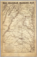
Author
Prang, L. & Co.
Full Title
War Telegram Marking Map. L. Prang & Co. Print Publishers, 159, Washington St. Boston ... Entered ... 1862 by L. Prang & Co. ... Massachusetts.
List No
4682.000
Note
In the "Explanations" below the map Prang states that this is "a map to mark the change of positions of the Union forces in red pencil and the rebel forces in blue, on the receipt of every telegram from the seat of war..." He goes on to say that he will furnish the necessary pencils and that "with the aid of a little soft bread" prior markings can be erased to show the latest developments. Printed in brown ink, showing the area between Richmond and Washington in good detail.
Author
Semple, E.A.
Full Title
A Plan Of The Property Of The Hampton Normal And Agricultural Institute At Hampton Virginia. Surveyed by E.A. Semple, C.S. American Photo-Lithographic Company, N.Y. (Osborne's Process). S.C.A. Del. Mih. 1876.
List No
5307.000
Note
The Hampton Institute was one of the first black educational institutions in the United States. Outline color.
Author
Renault, Jn. F.
Full Title
Plan of York Town In Virginia And Adjacent Country. Exhibiting the operations of the American French & English armies, during the siege at that place in Oct. 1781. Surveyed from the 22nd to the 28th Octr. Drawn by Jn. F. Renault, with a Crow-pen and presented to the Marques De La Fayette. Engraved by B. Tanner.
List No
5331.000
Note
This is a engraved copy of the original 1782 map of Yorktown by Sebastian Bauman. This copy was made in 1825 and presented to Lafayette on the occasion of his visit to America. The map is not dated, and we have taken the (1825) date from Fite and Freeman. Map is without color.
Author
Ensign, Bridgman & Fanning
Full Title
Our Nation's Camp Ground. Published By Ensign, Bridgman & Fanning, 156 William Street, N.Y. (with) Two inset maps of the Mid-Atlantic States and Washington. (with) 6 inset pictures.
List No
5438.000
Note
Full county color on the Mid-Atlantic map and partial color on the Washington inset. Inset pictures include: 2 drawings entitled "Star Spangled Banner" and "The Outrage On The American Flag At Fort Sumter"; 3 figures including a man holding the U.S. flag, Justice captioned "Justice Disarmed" and Liberty wrapped in the flag with the caption "Liberty Weeping"; 1 drawing of citizens saluting the flag, constitution & laws. Quote at top reads, "If any one attempts to haul down the American Flag shoot him on the spot."--Gen. John A. Dix.
Author
Hughes, W.C. Major
Full Title
Hughes Military Map Of Richmond & Petersburgh, Va. Showing the Rebel Fortifications drawn on the ground for the War Department by Major W.C. Hughes of Michigan. Published by Philip & Solomons, Washn. D.C. Print by J.F. Gedney, Washn. Willenbucher, Lith. Respectfully dedicated to the Army of the Potomac.
List No
5443.000
Note
Two color map on linen with blue used for the rivers. Two inset views entitled "Libby Prison" and "Belle Isle." Date estimated.
Author
Clegg, Ernest
Full Title
A descriptive map of the region within one hundred miles of the capital of the United States : portraying the principal events and places of major interest in the nation's political, cultural, and religious history : commemorating the two hundredth anniversary of the birth of George Washington. Published by Washington Cathedral, MCMXXXII (1932). Designed by Ernest Clegg.
List No
8241.000
Note
Pictorial historical map, hand colored, with 6 insets. Decorative title cartouche illustrating Washington Cathedral, seals and coats of arms. Includes text, and small banner-shaped labels with the names of places, buildings, monuments, mines, and historical notes. Shows explorer's ships and French fleets in Atlantic Ocean, compass rose on lower right oriented with north to the upper right, and view of Washington monument in lower center. Note: "Of this map there have been 200 copies printed in black and white, hand colored by Ernest Clegg. this is copy No."
Author
Tunis, Edwin, 1897-1973
Full Title
A map of the Chesapeake Bay : "land of pleasant living" Published by the National Brewing Company, Baltimore, Maryland, 1959. Edwin Tunis. National Bohemian Beer : From Chesapeake Bay ... and land of pleasant living.
List No
8244.000
Note
Pictorial map, with 12 color vignettes on left and right margins, showing historical events, sites, scenes, and vessels depicted representing Maryland and Virginia history 1524-1959. Shows boundaries, major buildings, houses, churches, carriages, animals, Native American sites, various mode of water transportation, and historical notes associated with illustrations.
|